Express Server: Standards-Based Image Delivery for the Geospatial Industry
|
|
|
- Shanon Young
- 8 years ago
- Views:
Transcription
1 Express Server: Standards-Based Image Delivery for the Geospatial Industry Advancements in the collection of geospatial imagery in recent years have resulted in the increasing availability of greater quantities of higher quality imagery, and that availability has been matched by increasing demand as business and nonbusiness users have grown to expect high-quality geospatial imagery in more applications on more devices. What has not changed is that the bandwidth available for transferring this imagery is limited, which means that, in general, delivery is the bottleneck in any workflow involving image repositories and end users. This paper describes a software solution that takes advantage of the architecture of the waveletbased MrSID and JPEG 2000 image formats to deliver high resolution imagery to more users, faster, over any connection. Published March 2015

2 Copyright 2015 Celartem Inc. d.b.a. LizardTech, 1008 Western Avenue, Suite 200, Seattle, WA Unauthorized use or distribution prohibited. Access to and use of this code is permitted only under license from LizardTech. All rights reserved. LizardTech, MrSID, GeoExpress, Express Server, and Express Suite are registered trademarks in the United States and LiDAR Compressor and the LizardTech, GeoExpress, Express Server, Express Suite, LiDAR Compressor, ExpressView and GeoViewer logos are trademarks, and all are the property of LizardTech. Unauthorized use is prohibited.

3 Contents Introduction... 1 Express Server Overview... 2 Comparison with Traditional Image Servers... 2 Express Server Architecture... 2 Clients... 4 Web Server... 4 LizardTech Services... 4 Image Server... 4 Image Data... 4 Supported Image Formats... 4 Visualizing Image Requests... 5 Hosting Imagery... 6 Image Catalogs... 6 Viewing Imagery... 7 Protocols... 7 Comparing Requests from WMS and the Express Server Web API... 7 JPIP Requests... 8 Conclusion Further Reading Glossary... 12

4 Introduction In recent years, the volume and variety of geospatial imagery has skyrocketed. Not only has the accuracy of satellite imagery increased, but so has the complexity. It is now common for new satellites to capture multispectral imagery with dozens of bands. Moreover, these improvements have been matched by the rise of microsatellites and unmanned aerial vehicles, both of which promise cheaper and more frequent image collection. All of this innovation however comes at the cost of increased image sizes, which for modern organizations presents new problems in the form of rapidly rising file storage costs and increased complexity when hosting and distributing the newly acquired imagery. Indeed, the need for reliable and storage efficient image-delivery has never been more pressing. In this white paper, LizardTech presents one solution to this problem using LizardTech s Express Server software, which delivers compressed MrSID and JPEG 2000 imagery to reduce storage costs and decrease image loading times.

5 Express Server Overview LizardTech Express Server is a software application for rapidly distributing high-resolution satellite imagery, aerial photographs, and other large raster datasets. Imagery hosted on Express Server is stored in the MrSID or JPEG 2000 image formats, which are compressed image formats that reduce storage costs and minimize required network bandwidth. MrSID is a patented compression technology perfected by LizardTech over twenty years, and JPEG 2000 is an ISO-standard file format though it was not created specifically for geospatial applications. Both file formats rely on similar advanced compression technologies, including the wavelet transform and arithmetic encoding. Comparison with Traditional Image Servers Express Server reads and serves imagery directly from compressed source images to reduce storage costs. This is in contrast to traditional image servers, also called tile servers, which generate and cache tiled images from the source images hosted on the server. By creating these tiled images, the tile server avoids reading an entire source image every time that a small portion of the image is requested. Although this increases the efficiency of the server, it requires duplicating the source image data at multiple resolutions, such that the cached tiles are often several times the size of the source image. The exceptional characteristic of Express Server is that it can read directly from compressed images without sacrificing responsiveness and efficiency. This special quality is due to the wavelet-based nature of the MrSID and JPEG 2000 formats which can be decompressed selectively and can incorporate multiple image resolutions without duplicating image data. With MrSID and JPEG 2000 encoding, images are compressed such that multiple resolution levels of an image, from an overview all the way up to the full resolution, are the natural result of compressing the image. Additionally, because of the way the actual bits representing the image are stored, any portion of an image can be decompressed at any resolution level without the necessity of decoding the entire image. Express Server is built specifically to take advantage of this selective decompression feature of MrSID and JPEG 2000, extracting the requested scene quickly and converting it to an image scene in one of several output formats. Express Server Architecture Express Server runs on top of an existing web server and provides access to compressed imagery stored on the server s file system or on the network. Clients can then connect to the web server using multiple protocols, including the OGC Web Map Service (WMS) standard, the streaming JPEG 2000 Interactive Protocol (JPIP), and an Express Server-specific web API.

6 Figure 1: Express Server Architecture
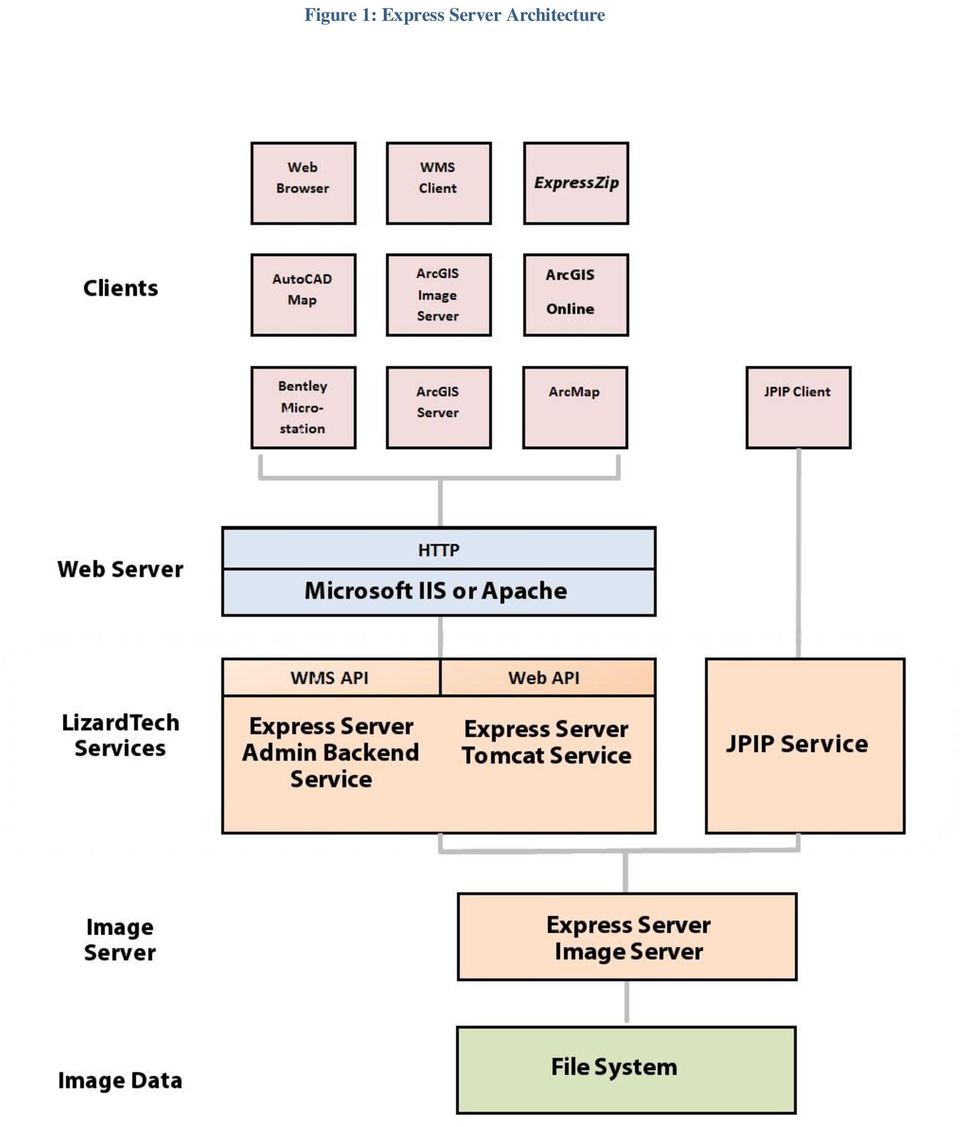
7 Clients Express Server imagery can be accessed from any WMS client. WMS is a widely-supported standard that users can access to view imagery from web browsers, from desktop GIS applications, from the ExpressZip web application included with Express Server, and more. If the optional Express Server JPIP component is installed, then users can also access imagery from JPIP clients. Web Server Express Server works in conjunction with an existing web server installation to distribute imagery. Express Server is compatible with both the Microsoft IIS web server on Windows and the Apache web server on Linux. LizardTech Services LizardTech services provide an interface between the web server and the image server. The following list describes the LizardTech services created during the installation of Express Server: Express Server Admin Backend Service. The Admin Backend service, or the Express Server Agent, processes requests from the Express Server Manager to start or stop the web server and perform licensing tasks. Express Server Tomcat Service. The Tomcat service runs the Express Server web applications, including Express Server Manager for managing Express Server and ExpressZip for image-export. JPIP Service. The JPIP service is an optional service added during the Express Server installation. The JPIP service processes requests from JPIP clients. Image Server The image server is the core of the Express Server installation and processes all image requests. When users connect to Express Server, the image server receives the image request and renders the image. By default Express Server delivers extracted scenes as JPEG images. Other options for final delivery format are PNG (.png), GIF (.gif), TIFF (.tif and.tiff) and Bitmap (.bmp). Image Data The source image data distributed by Express Server is stored on a local or network file system. Express Server supports MrSID, JPEG 2000 and NITF imagery. Supported Image Formats MrSID and JPEG 2000 are both wavelet-based formats that facilitate the efficiencies of raster data storage and distribution. Because their wavelet-based algorithms naturally and automatically result in multiple resolutions of an image within the compressed image file itself from the full resolution image down to a

8 low-resolution thumbnail both formats provide the high image quality required by geospatial professionals yet obviate costly and time-consuming image pyramiding. MrSID images are identified by generation and may be MrSID Generation 2 (MG2 ), MrSID Generation 3 (MG3 ) or MrSID Generation 4 (MG4 ). There are important differences among them. MG2, the oldest version, has a 2-gigabyte file-size limit and does not support lossless compression. MG3 introduced support for lossless compression and a number of other features including reprojection, color balancing, despeckling and encoding areas of interest, and removed the 2-GB size limit. MG4 is the most recent evolution of the MrSID format. In addition to mosaicking datasets together, color balancing raster imagery, and manipulating data in other ways as do MG2 and MG3, MG4 enables geospatial professionals to losslessly compress 3-banded and multispectral (including hyperspectral) geospatial data so that they can make full use of the most up-to-date imagery. MG4 also introduced support for alpha bands, which remove the problem of speckling in the transparency areas of mosaics. The following table illustrates the differences between versions of the MrSID format and JPEG Table 1: Support for Common Requirements in LizardTech File Formats Situation/Requirement Supported by Output File Format MG2 MG3 MG4 JPEG 2000 Lossy output with maximum 3 bands, cropping but no advanced encoding, output less than 2 GB* Advanced encoding (reprojection, color balancing, despeckling, area of interest encoding, etc.) Output file size greater than 2 GB Lossless output Mosaic that has MrSID tiles as input Multispectral input Optimization Alpha band Signed datatypes (e.g. s8, s16) Arbitrary band mapping Per-band compression NITF (National Imagery Transmission Format) is a suite of standards for the exchange, storage, and transmission of digital-imagery products and image-related products within the U.S. Department of Defense and the Federal Intelligence Community. NITF supports compression to JPEG 2000 format. Visualizing Image Requests The diagram below illustrates the roundtrip of an image request to Express Server and back. Once a client image request is received by the web server, the request is recognized as belonging to one of the protocols supported by Express Server. The Express Server engine then: determines what reader to use locates and opens the image after consulting the various caches

9 extracts the requested scene based on requested parameters such as level (resolution), width and height, and geospatial coordinates engages an image writer based on the specified output format delivers the image Figure 2: Visualizing Image Requests Hosting Imagery Express Server hosts imagery directly from a local or network file system. This file-system based approach simplifies image management and requires minimal server administration. Administrators can use a simple web-based administration tool called the Express Server Manager to point Express Server to the location of imagery on the file system and configure Express Server settings. Images on the file system correspond to image catalogs in Express Server. Catalogs are simply image directories that administrators make accessible on the server. Image Catalogs Express Server treats every image as part of a catalog. The catalog is the basic edifice used by Express Server to organize images and house information about them and instructions about how to treat them. For the purposes of WMS, a catalog is the same thing as a layer. Additionally, catalogs can be organized into catalog groups so that users can view multiple related image catalogs through a single virtual catalog. Catalogs include several configuration options which change how the image appears to users. For example, administrators can configure the following properties for each catalog: the name of the catalog

10 the directory of the images that make up the catalog whether the catalog should have an overview image the coordinate reference system to use for the catalog the image bands to display if the image is a multispectral image Viewing Imagery Express Server s architecture is standards-based, which enables image delivery quickly to virtually any client viewer, regardless of the device or the amount of bandwidth. Express Server responds to a request formulated according to one of three protocols: WMS, JPIP, or the Express Server web API. Each request is in the form of a URL. Protocols The Web Map Service standard (WMS) provides a simple HTTP interface for requesting georeferenced map images from one or more distributed geospatial databases. A WMS request defines the geographic layer(s) and area of interest to be processed. The response to the request is one or more georeferenced map images (returned as JPEG, PNG, etc.) that can be displayed in a WMS-enabled GIS application. The WMS protocol is an Open Geospatial Consortium standard, and is nearly universal among GIS applications and GIS viewers. The JPIP client/server communication protocol is defined in Part 9 of the JPEG 2000 suite of standards, (ISO/IEC ). JPIP progressively streams the wavelet coefficients for a requested part of a picture, which saves bandwidth, computer processing on the server, and time. It allows for speedy viewing of a large image in low resolution or a higher-resolution part of that same image. Using JPIP, it is possible to stream large images (for example 1 gigapixel) to relatively lightweight hardware such as mobile tablet devices. Comparing Requests from WMS and the Express Server Web API Though the syntax of the requests is different, the WMS API is functionally equivalent to the web API. Express Server s web API enables web browsers to make requests for images or scenes from images according to various specified parameters. The URL request can be formed either through the clicking of graphic elements or by manual entry in the URL field. The WMS API essentially does the same thing, but WMS was created as a standard means of importing data in diverse locations into a GIS. The WMS API enables geospatial applications to pull in Express Server catalogs as layers. A catalog is WMS-enabled (available for WMS requests) when it is spatially indexed. This means that Express Server understands how to fit all the images in a catalog into a mosaic and has assigned the catalog a coordinate reference system (CRS) in the form of an EPSG code. Instead of having to open each image in the catalog to find out where it belongs in the world and in the mosaic, Express Server consults a single index file that contains this information for all the images in the catalog. The following two requests both return a summary of available catalogs on an Express Server installation hosted at demo.lizardtech.com. The first is a WMS API request, the second a web API request. Express
 provides a simple HTTP interface for requesting georeferenced map images from one or more distributed geospatial databases.")
11 Server supports version of the OGC WMS specification via the GetCapabilities and GetMap calls. The reply sent back by Express Server is an XML document (which in the web API gets turned into an html page displaying thumbnails of the available catalogs). The above URLs are live and will each return XML output. A user will not normally see the XML, but a look at some XML excerpts will show some interesting items. Below is the return from a WMS GetCapabilities request showing one catalog. Note that it is referred to as a layer, and that the extents are described in terms of a bounding box. <Layer opaque="1"> <Name>Florida</Name> <Title>Florida</Title> <SRS>EPSG:26917</SRS> <LatLonBoundingBox maxx=" " maxy=" " minx=" " miny=" " /> <BoundingBox SRS="EPSG:26917" maxx=" " maxy=" " minx=" " miny=" " resx=" " resy=" " /> <ScaleHint max=" " min=" " /> </Layer> Note: For more information about how the various XML elements are used in WMS requests and what their values signify see the Further Reading section at the end of this document. Below is the same catalog listed in the return from a web API browse request. <Item georgn=" , , , " name="florida" srs="epsg:26917" /> Following is a WMS request to open the catalog which it identifies as the layer called Florida. We ve broken up the URL into rows so it can be viewed more easily. &VERSION=1.1.1 &REQUEST=GetMap &LAYERS=Florida &SRS=EPSG:26917 &BBOX= , , , &WIDTH=600 &HEIGHT=500 &FORMAT=image/jpeg &TRANSPARENT=FALSE In the web API, the same catalog is requested using the getimage command, as follows: cat=florida&item=iserv-catalog-index &rgn= , , , &geo=true &wid=600&hei=500&method=scale &oif=jpeg The above examples demonstrate the basic methods by which clients retrieve imagery and information from Express Server. They are live examples that both open the same Florida mosaic. JPIP Requests Express Server s JPIP API is an optional component that works with any JPIP viewing client.

12 In a JPIP transaction, the viewing client sends a request for a connection along with some information about how large of a chunk of image data it wants to receive at a time and a summary of what it knows about the imagery it hopes to view. The server sends back a channel ID number and opens a transfer session. The channel ID number identifies the session and is used by the client in each subsequent request for more data. Because Express Server s JPIP server component streams wavelet coefficients instead of sending images there is always something to render in a JPIP viewer. Image detail is filled in as it arrives. This can be taken advantage of in several ways depending on the capabilities of the viewing client. For example, the image data might be requested in such a way that priority is placed on rendering the entire image at low- quality before more detail is rendered in any given portion of the image, or the opposite might be requested: an area of interest can be specified that receives priority as the data is being delivered, and where the maximum image detail is filled in first. In practice, a user might open the image as a layer in a GIS application and, before the image renders at full quality, draw a rectangle specifying an area of interest. At that point, Express Server stops filling in the entire image and focuses on supplying image data for just that area of interest. For example, compare the following two requests from a JPIP viewer: xl<0>&len=2000&cid=jph_fffc70d c1: ntext=jpxl<0>&len=2000&cid=jph_fffc70d c1 Note: For more information about how the various XML elements are used in JPIP requests and what their values signify see the Further Reading section at the end of this document. Important words have been highlighted for emphasis. In both URLs you can see the channel ID number (cid) at the end. Also, the desired chunk size or length of the stream (len) is 2000 bytes in both. You ll notice that in the first URL, fsiz (the size of the entire image) and rsiz (the size of the region of interest) are the same 482 pixels on the x axis and 813 on the y axis and that the roff (region offset) has a value of zero, which means that there is no particular region of interest being specified. The region starts in the upper left corner of the image (0,0) and is the same size as the image. In this case the detail for the entire image will be filled in at an even rate. But in the second URL (see Figure 3 below) there is an offset of 3228 pixels on the x axis and 2480 on the y axis and the size of the area of interest is only a small part of the image 267 pixels by 169 pixels. In this case Express Server will send the detail for that smaller region first. This is just one application of the capabilities of the JPIP protocol in Express Server software.

13 Figure 3: A JPIP Region of Interest

14 Conclusion Express Server is a technologically advanced and efficient method of serving raster imagery that has been compressed to MrSID and JPEG 2000 format. Because it is designed to take advantage of the multiresolution nature of these formats and their support for selective decoding, Express Server used with other GIS image servers delivers imagery faster than those image servers can do alone, especially as the number of concurrent requests and size of imagery increase. As geospatial image data increases both in quality and in quantity, so does user demand for that imagery, especially now that applications with geospatial components are in the hands of millions of everyday mobile users. Express Server is the fastest and most efficient method for ensuring that the imagery will be there whenever and wherever users need it. Further Reading For more information about LizardTech Express Server see the following: The Express Server product page at Express Server s online documentation at Case Study: Air Force Special Operations Command Case Study: State of New Jersey Office of Geographic Information Systems Case Study: Quebec Ministry of Sustainable Development, Environment and Parks For more information about Web Map Service (WMS) see the following: The WMS specification, available for download on the Open Geospatial Consortium (OGC) website: For information about JPIP see the following: JPEG 2000 Interactive Protocol (Part 9 JPIP) at The JPIP specification, available for download at the International Telecommunication Union (ITU) website:

15 Glossary Following is a list and definitions of several words, phrases and acronyms appearing in the foregoing text. alpha band also called alpha channel. An additional band used to contain masking or transparency information about other bands in an image. See also transparency. API A language and message format used by an application program to communicate with the operating system, communications protocol or some other control program. band a set of samples corresponding to one spectral component of an image, e.g. the red band of an RGB image. Bitmap a raster graphics image file format used to store bitmap digital images, independently of the display device (such as a graphics adapter), especially on Microsoft Windows and OS/2 operating systems. Also known as BMP. The BMP file format is capable of storing 2D digital images of arbitrary width, height, and resolution, both monochrome and color, in various color depths, and optionally with data compression, alpha channels, and color profiles. cache generally, a component that transparently stores data so that future requests for that data can be served faster. Express Server employs several cache strategies in concert for optimal performance. catalog an array of folders with images in them, located on one or more file systems to which Express Server has access. A catalog can also be a single indexed image. client the viewing computer or application. More broadly, the requesting end of the spectrum in a request/supply relationship between programs. composite mosaic a compressed MrSID mosaic in which all the input tiles remain individual images wrapped by a single file structure. Unlike in a flat mosaic, which becomes a single image upon encoding, any image in a composite mosaic can be updated in place. See also flat mosaic and mosaic. compression an operation that creates a new image file from an original image file such that the file size of the new image is smaller. The reduction in file size may be at the expense of some image quality. (Note that the file size is what is reduced, not the dimensions of the image itself.) See also lossless and lossy. coordinate reference system (also referred to as CRS, projection, spatial reference system, SRS), a coordinate-based local, regional or global system used to locate geographical entities. A coordinate reference system defines a specific map projection, as well as transformations between different coordinate reference systems. Coordinate reference systems are defined by the OGC's Simple feature access using well-known text, and support has been implemented by several standards-based geographic information systems. Coordinate reference systems can be referred to using a SRID integer, including EPSG codes defined by the International Association of Oil and Gas Producers. CRS See coordinate reference system. despeckling a process by which pixel values that have been slightly changed in compression are returned to the specified transparency value to eliminate artifacts, usually a speckling in collar or "no- data" areas.

16 element a discrete section of an XML document. An element can contain other elements, which can then be thought of as subelements. See also XML. EPSG code a series of numbers representing a coordinate reference system recognized as one in a set compiled by the European Petroleum Survey Group (EPSG). EPSG was a scientific organization consisting of specialists working in applied geodesy, surveying, and cartography related to oil exploration. EPSG compiled and disseminated the EPSG Geodetic Parameter Set, a widely used database of Earth ellipsoids, geodetic datums, geographic and projected coordinate reference systems, units of measurement, etc. An example of an EPSG code is 4326, which identifies the coordinate reference system WGS 84. flat mosaic a mosaic of tiled images that has been encoded as a new, single image, as opposed to a composite mosaic, which is an indexed image file wrapping many separate image tiles. Any tile in a composite mosaic can be replaced in an update operation. In a flat mosaic the original tiles that comprise it do not retain separate identities. See also composite mosaic and mosaic. georeferenced defined in physical space. The location of a georeferenced image is established in terms of map projections or coordinate reference systems. GIF (Graphics Interchange Format) a bitmapped graphics file format developed by CompuServe and widely used on the Internet. grayscale having a single sample for a value, rather than three (RGB) or more (multispectral). A grayscale pixel carries only intensity information. Grayscale images, also known as black-and-white, are composed exclusively of shades of gray, varying from black at the weakest intensity to white at the strongest. HTTP (HyperText Transfer Protocol) the communications protocol used to connect to web servers on the Internet or on a local network (intranet). Its primary function is to establish a connection with the server and send HTML pages back to the user's browser. It is also used to download files from the server either to the browser or to any other requesting application that uses HTTP. hyperspectral see multispectral. image pyramid a digital image storage construct in which multiple versions of the same image are created at different resolutions for responding to image queries at various zoom levels. For comparison see multiresolution. JPEG 2000 an image compression standard and coding system created by the Joint Photographic Experts Group committee in Their purpose was to supersede their original discrete cosine transform-based JPEG standard (created in 1992) with a newly designed, wavelet-based method. JPIP (JPEG 2000 Interactive Protocol) a compression streamlining protocol that works with JPEG 2000 to produce an image using the least possible bandwidth. JPIP has the capacity to download only the requested part of a picture, saving bandwidth, computer processing on both ends, and time. It allows for the relatively quick viewing of a large image in low resolution or a particular region of the same image at a higher resolution. layer with regard to Express Server, an image or catalog of images spatially indexed for viewing in a GIS via WMS.

17 lossless encoded with no loss of data. A losslessly encoded image contains a representation of all of the original pixel values. When decoded, a lossless image is mathematically identical to the original. See also lossy. lossy encoded in such a way that some image data is permanently discarded. A lossy image contains an approximation of all of the original pixel values. When decoded, depending on the quality of the compression, a lossy image may appear to be a poor representation of the original, visually indistinguishable from the original, or anywhere in between. The perceived image quality is affected by changes in the sharpness of edges, color balance, reduced resolution, and so forth. See also lossless. MG2 see MrSID. MG3 see MrSID. MG4 see MrSID. mosaic a composition of two or more images to form a new, larger image. Positioning of the images is generally based on geospatial coordinates. See also composite mosaic and flat mosaic. MrSID MrSID is a wavelet-based image format designed for large, high-quality geospatial imagery. There are three versions of MrSID, known as MrSID Generation 2 (MG2), MrSID Generation 3 (MG3) and MrSID Generation 4 (MG4). MG2, the first released version of the format, is limited to lossy encoding and does not support optimization. MG3, the second version, supports lossless encoding, image optimization, and composite images. MG4, the most recent version, supports alpha bands, multispectral imagery, and improved composite mosaicking. multiresolution containing all the image data for multiple representations of an image at different resolutions. MrSID images are multiresolution images, in that a single MrSID file contains compressed data that viewers decode at any desired resolution or zoom level. For comparison see image pyramid. multispectral having more than three bands. A multispectral image contains image data at a range of frequencies across the electromagnetic spectrum. An example of a multispectral image is RGB-IR, which contains bands housing data from the red, green and blue wavelengths plus an infrared band. Multispectral imagery includes hyperspectral imagery, which contains potentially hundreds of bands that correspond to extremely narrow divisions of the spectrum. NITF/NITFS (National Imagery Transmission Format Standard) a suite of standards developed and used by the U.S. Department of Defense and Federal Intelligence Community for the exchange, storage, and transmission of digital-imagery products and image-related products. no-data See transparency. OGC (Open Geospatial Consortium) an international voluntary consensus standards organization that originated in In the OGC, more than 400 commercial, governmental, nonprofit and research organizations worldwide collaborate in a consensus process encouraging development and implementation of open standards for geospatial content and services, GIS data processing and data sharing. optimization the process of creating an MG3 image from a source MG3 image, such that the new image is better suited for some purpose or workflow. The most common optimization is compression; other optimization operations include cropping and removal of resolution levels. PDA (Personal Digital Assistant) A handheld computer for using personal productivity applications such

18 as those for managing contacts, appointments and tasks.. PNG (Portable Network Graphics) A bitmapped graphics file format endorsed by the World Wide Web Consortium. port an application-specific or process-specific software construct serving as a communications endpoint in a computer's host operating system. A port is associated with an IP address of the host, as well as the type of protocol used for communication. projection See coordinate reference system. raster image a dot matrix data structure representing a generally rectangular grid of pixels, or points of color, viewable via a monitor, paper, or other display medium. Raster images are stored in image files with varying formats. reprojection the process of changing the coordinate reference system or projection that an image is displayed in. See also coordinate reference system. resolution the scale at which an image is represented, as expressed in pixel dimensions. Resolution can also refer to ground units per pixel as used for georeferencing (a value stored in the metadata of an image). See also zoom level. RGB an additive color model in which red, green, and blue light is added together in various ways to reproduce a broad array of colors. The name of the model comes from the initials of the three additive primary colors, red, green, and blue. The main purpose of the RGB color model is for the sensing, representation, and display of images in electronic systems, such as televisions and computers. scene the area of an image requested by the client for viewing, anything from a zoomed-in portion of the image to the entire image. In the rendering of a requested scene all portions of the image that constitute any part of that scene at the quality specified are decoded and delivered. selective decompression decoding of a portion of an image or mosaic so that some image data can be viewed immediately, as opposed to decoding the entire image before showing any desired portion. spatial index an index used to optimize spatial queries or, in this case, requests for imagery. A spatial index describes the spatial relationship of each image in a catalog to every other image in that catalog, enabling Express Server to mosaic the images together so that each image is in the right place and is correct according to a given projection system. speckling artifacts in collar or "no-data" areas of a mosaicked image caused by drifting pixel values during compression. See also despeckling. streaming in Express Server s JPIP implementation, transmitting wavelet coefficients from a compressed image file instead of transmitting an image. See wavelet coefficients. TIFF (Tagged Image File Format) A bitmapped graphics file format developed by Aldus Corporation that handles monochrome, gray scale, 8-and 24-bit color. transparency also called no-data. A feature of some image file formats, including MrSID and JPEG 2000, whereby pixel data in specified areas are ignored in favor of imagery underneath. In an image mosaic source tiles often overlap, and valid image data in one tile is sometimes covered by non-image (collar) data

19 from another. A transparency color value can be assigned so that any pixel whose values match the transparency value is discarded in favor of the pixel below it. wavelet coefficients arrays of numbers arrived at via a wavelet-based mathematical algorithm. Wavelet coefficients represent a given set of image data s spatial position within an image, scale (or resolution ), and quality contribution. wavelet a mathematical representation of a pixel value that varies by frequency and duration; in wavelet space, the importance of a pixel depends on the values of its neighboring pixels. Wavelet-based image formats are able to present images at multiple levels of resolution without the overhead of pyramidal formats. See also multiresolution and image pyramid. WMS (Web Map Service) a standard protocol for serving georeferenced map images over the Internet that are generated by a map server using data from a GIS database. The specification was developed and first published by the Open Geospatial Consortium in XML (Extensible Markup Language) a markup language that defines a set of rules for encoding documents in a format that is both human-readable and machine-readable. It is defined in the XML 1.0 Specification produced by the World Wide Web Consortium (W3C). zoom level the resolution of an image expressed as a scale or magnification number. See also resolution.

How Express Server Software Improves Geospatial Image Delivery
 How Express Server Software Improves Geospatial Image Delivery A LIZARDTECH WHITE PAPER contact: Jon Skiffington 206-652-5211 jskiffington@lizardtech.com Written by Matt Fleagle Published June 2012 Copyright
MrSID Plug-in for 3D Analyst
 LizardTech MrSID Plug-in for 3D Analyst User Manual Copyrights Copyright 2009 2010 LizardTech. All rights reserved. Information in this document is subject to change without notice. The software described
LizardTech. Express Server 9. User Manual
 LizardTech Express Server 9 User Manual Copyright 2009 2014 Celartem Inc. d.b.a. LizardTech. All rights reserved. Information in this document is subject to change without notice. The software described
LizardTech s MrSID Technology
 LizardTech s MrSID Technology contact: Jon Skiffington 206-652-5211 jskiffington@lizardtech.com For over a decade, the MrSID technology from LizardTech has been the GIS industry s leading solution to the
INTEROPERABLE IMAGE DATA ACCESS THROUGH ARCGIS SERVER
 INTEROPERABLE IMAGE DATA ACCESS THROUGH ARCGIS SERVER Qian Liu Environmental Systems Research Institute 380 New York Street Redlands, CA92373, U.S.A - qliu@esri.com KEY WORDS: OGC, Standard, Interoperability,
Digital Image Fundamentals. Selim Aksoy Department of Computer Engineering Bilkent University saksoy@cs.bilkent.edu.tr
 Digital Image Fundamentals Selim Aksoy Department of Computer Engineering Bilkent University saksoy@cs.bilkent.edu.tr Imaging process Light reaches surfaces in 3D. Surfaces reflect. Sensor element receives
Interoperable Solutions in Web-based Mapping
 ISPRS SIPT IGU UCI CIG ACSG Table of contents Table des matières Authors index Index des auteurs Search Recherches Exit Sortir Interoperable Solutions in Web-based Mapping Marta Wojnarowska and Bridget
Big Data Volume & velocity data management with ERDAS APOLLO. Alain Kabamba Hexagon Geospatial
 Big Data Volume & velocity data management with ERDAS APOLLO Alain Kabamba Hexagon Geospatial Intergraph is Part of the Hexagon Family Hexagon is dedicated to delivering actionable information through
Comparison of different image compression formats. ECE 533 Project Report Paula Aguilera
 Comparison of different image compression formats ECE 533 Project Report Paula Aguilera Introduction: Images are very important documents nowadays; to work with them in some applications they need to be
FME 2007 Release Giving Raster the Vector Treatment. By Mary Jo Wagner
 FME 2007 Release Giving Raster the Vector Treatment By Mary Jo Wagner Giving Raster the Vector Treatment By Mary Jo Wagner Spatial extract, transform and load (ETL) tools such as Safe Software s FME have
ArcGIS. Image Server tutorial
 ArcGIS 9 ArcGIS Image Server tutorial Copyright 2006, 2007, and 2008 Zanja Technologies, Inc. All rights reserved. The information contained in this work is the property of Zanja Technologies, Inc., under
CURSO Inspire INSPIRE. SPEAKER: Pablo Echamendi Lorente. JEUDI 23/ THURSDAY 23 rd W S V : G E O S P A T I A L D A T A A C C E S S
 CURSO Inspire JEUDI 23/ THURSDAY 23 rd SPEAKER: Pablo Echamendi Lorente WS 5 SCHEDULE WMS OVERVIEW ACTIONS OGC SPECIFICATIONS OTHER SERVICES OVERVIEW proposal: Member States shall establish and operate
MassArt Studio Foundation: Visual Language Digital Media Cookbook, Fall 2013
 INPUT OUTPUT 08 / IMAGE QUALITY & VIEWING In this section we will cover common image file formats you are likely to come across and examine image quality in terms of resolution and bit depth. We will cover
Reduce File Size. Compatibility. Contents
 Reduce File Size Revu provides a mechanism for reducing the size of some PDFs to make them more suitable for email or a Document Management System. This tool works by compressing bitmap images and removing
Introduction to Imagery and Raster Data in ArcGIS
 Esri International User Conference San Diego, California Technical Workshops July 25, 2012 Introduction to Imagery and Raster Data in ArcGIS Simon Woo slides Cody Benkelman - demos Overview of Presentation
How to Send Video Images Through Internet
 Transmitting Video Images in XML Web Service Francisco Prieto, Antonio J. Sierra, María Carrión García Departamento de Ingeniería de Sistemas y Automática Área de Ingeniería Telemática Escuela Superior
Jozef Matula. Visualisation Team Leader IBL Software Engineering. 13 th ECMWF MetOps Workshop, 31 th Oct - 4 th Nov 2011, Reading, United Kingdom
 Visual Weather web services Jozef Matula Visualisation Team Leader IBL Software Engineering Outline Visual Weather in a nutshell. Path from Visual Weather (as meteorological workstation) to Web Server
MMGD0203 Multimedia Design MMGD0203 MULTIMEDIA DESIGN. Chapter 3 Graphics and Animations
 MMGD0203 MULTIMEDIA DESIGN Chapter 3 Graphics and Animations 1 Topics: Definition of Graphics Why use Graphics? Graphics Categories Graphics Qualities File Formats Types of Graphics Graphic File Size Introduction
Standard-Compliant Streaming of Images in Electronic Health Records
 WHITE PAPER Standard-Compliant Streaming of Images in Electronic Health Records Combining JPIP streaming and WADO within the XDS-I framework 03.09 Copyright 2010 Aware, Inc. All Rights Reserved. No part
Advanced Image Management using the Mosaic Dataset
 Esri International User Conference San Diego, California Technical Workshops July 25, 2012 Advanced Image Management using the Mosaic Dataset Vinay Viswambharan, Mike Muller Agenda ArcGIS Image Management
Smithsonian Institution Archives Guidance Update SIA. ELECTRONIC RECORDS Recommendations for Preservation Formats. November 2004 SIA_EREC_04_03
 SIA Smithsonian Institution Archives Guidance Update November 2004 ELECTRONIC RECORDS Recommendations for s SIA_EREC_04_03 Highlights Highlights of SIA_EREC_04_03, an update on electronic record preservation
Digimarc for Images. Best Practices Guide (Chroma + Classic Edition)
") Digimarc for Images Best Practices Guide (Chroma + Classic Edition) Best Practices Guide (Chroma + Classic Edition) Why should you digitally watermark your images? 3 What types of images can be digitally
Digimarc for Images Best Practices Guide (Chroma + Classic Edition) Best Practices Guide (Chroma + Classic Edition) Why should you digitally watermark your images? 3 What types of images can be digitally
In addition, a decision should be made about the date range of the documents to be scanned. There are a number of options:
 Version 2.0 December 2014 Scanning Records Management Factsheet 06 Introduction Scanning paper documents provides many benefits, such as improved access to information and reduced storage costs (either
Scanning in Windows XP: Basics Learning guide
 Scanning in Windows XP: Basics Learning guide If you have ever wanted to scan documents and images on different scanners in your department, you've probably faced the difficulties that arise from needing
Mail Programming Topics
 Mail Programming Topics Contents Introduction 4 Organization of This Document 4 Creating Mail Stationery Bundles 5 Stationery Bundles 5 Description Property List 5 HTML File 6 Images 8 Composite Images
Matsu Workflow: Web Tiles and Analytics over MapReduce for Multispectral and Hyperspectral Images
 Matsu Workflow: Web Tiles and Analytics over MapReduce for Multispectral and Hyperspectral Images Open Cloud Consortium Open Data Group September 7, 2012 1 Materials for Matsu Matsu is a public project.
Server GIS. What Server GIS software do we provide?
 Server GIS Distribute maps, models, and tools via the Web in a way that fits well into your workflows. SuperGeo offers numerous Server GIS solutions to fulfill the demands of corporate Intranets and the
Oklahoma s Open Source Spatial Data Clearinghouse: OKMaps
 Oklahoma s Open Source Spatial Data Clearinghouse: OKMaps Presented by: Mike Sharp State Geographic Information Coordinator Oklahoma Office of Geographic Information MAGIC 2014 Symposium April 28-May1,
DISMAR implementing an OpenGIS compliant Marine Information Management System
 DISMAR implementing an OpenGIS compliant Marine Information Management System Éamonn Ó T uama, Coastal & Marine Resources Centre, ERI, University College Cork. DISMAR DISMAR (Data Integration System for
5.1 Computer Graphics Metafile. CHAPTER 5 Data Interchange Standards
 CHAPTER 5 Data Interchange Standards Data Interchange Services define common formats and semantics to facilitate the exchange of information and data between applications independent of the computer platforms,
ELECTRONIC DOCUMENT IMAGING
 AIIM: Association for Information and Image Management. Trade association and professional society for the micrographics, optical disk and electronic image management markets. Algorithm: Prescribed set
Adobe Marketing Cloud Sharpening images in Scene7 Publishing System and on Image Server
 Adobe Marketing Cloud Sharpening images in Scene7 Publishing System and on Image Server Contents Contact and Legal Information...3 About image sharpening...4 Adding an image preset to save frequently used
Supervised Classification workflow in ENVI 4.8 using WorldView-2 imagery
 Supervised Classification workflow in ENVI 4.8 using WorldView-2 imagery WorldView-2 is the first commercial high-resolution satellite to provide eight spectral sensors in the visible to near-infrared
MrSID Viewer for MicroStation Beta 2.0
 MrSID Viewer for MicroStation Beta 2.0 Contents of this guide Installation.......................................... 3 Operation........................................... 3 Image Viewing...........................................
Getting Started With LP360
 Getting Started With LP360 10/30/2014 1 Contents What is LP360?... 3 System Requirements... 3 Installing LP360... 4 How to Enable the LP360 Extension... 4 How to Display the LP360 Toolbar... 4 How to Import
Image Resolution. Color Spaces: RGB and CMYK. File Types and when to use. Image Resolution. Finding Happiness at 300 dots-per-inch
 Image Resolution Color Spaces: RGB and CMYK File Types and when to use Image Resolution Finding Happiness at 300 dots-per-inch Rules to remember Text should be 400dpi at the final size in the layout. Images
JPEG Image Compression by Using DCT
 International Journal of Computer Sciences and Engineering Open Access Research Paper Volume-4, Issue-4 E-ISSN: 2347-2693 JPEG Image Compression by Using DCT Sarika P. Bagal 1* and Vishal B. Raskar 2 1*
There are various ways to find data using the Hennepin County GIS Open Data site:
 Finding Data There are various ways to find data using the Hennepin County GIS Open Data site: Type in a subject or keyword in the search bar at the top of the page and press the Enter key or click the
How To Use The Alabama Data Portal
 113 The Alabama Metadata Portal: http://portal.gsa.state.al.us By Philip T. Patterson Geological Survey of Alabama 420 Hackberry Lane P.O. Box 869999 Tuscaloosa, AL 35468-6999 Telephone: (205) 247-3611
ART 170: Web Design 1
 Banner Design Project Overview & Objectives Everyone will design a banner for a veterinary clinic. Objective Summary of the Project General objectives for the project in its entirety are: Design a banner
Digital Imaging and Image Editing
 Digital Imaging and Image Editing A digital image is a representation of a twodimensional image as a finite set of digital values, called picture elements or pixels. The digital image contains a fixed
TEXT FILES. Format Description / Properties Usage and Archival Recommendations
 TEXT FILES Format Description / Properties Usage and Archival Recommendations.txt.doc.docx.rtf.odt.pdf PDF/A Text file Simple plain text document Compatible across software packages Supports very little
ES341 Overview of key file formats and file extensions in ArcGIS
 ES341 Overview of key file formats and file extensions in ArcGIS Commonly Encountered File Types/Extensions in ArcGIS.mxd A file containing a map, its layers, display information, and other elements used
Keystone Image Management System
 Image management solutions for satellite and airborne sensors Overview The Keystone Image Management System offers solutions that archive, catalogue, process and deliver digital images from a vast number
Electronic Records Management Guidelines - File Formats
 Electronic Records Management Guidelines - File Formats Rapid changes in technology mean that file formats can become obsolete quickly and cause problems for your records management strategy. A long-term
balesio Native Format Optimization Technology (NFO)
") balesio AG balesio Native Format Optimization Technology (NFO) White Paper Abstract balesio provides the industry s most advanced technology for unstructured data optimization, providing a fully system-independent
balesio AG balesio Native Format Optimization Technology (NFO) White Paper Abstract balesio provides the industry s most advanced technology for unstructured data optimization, providing a fully system-independent
AN OPENGIS WEB MAP SERVER FOR THE ESA MULTI-MISSION CATALOGUE
 AN OPENGIS WEB MAP SERVER FOR THE ESA MULTI-MISSION CATALOGUE T. Westin a, *, C. Caspar b, L. Edgardh a, L. Schylberg c a Spacemetric AB, Tingsv 19, 19161 Sollentuna, Sweden - tw@spacemetric.se b ESA Esrin,
GIS Beyond the Basics: Web Maps and File Sharing Services
 GIS Beyond the Basics: Web Maps and File Sharing Services by Julie Coco, PE I. INTRODUCING WEB-BASED GIS SERVICES A GIS service, or Geoservice, provides a way to retrieve maps, images, or geoprocessing
MrSID Viewer 2.0 for Windows 95/NT4.0
 MrSID Viewer 2.0 for Windows 95/NT4.0 What is MrSID? Introducing MrSID MrSID image compression and decompression software offers users high-quality image-compression capabilities, along with the ability
PaperlessPrinter. Version 3.0. User s Manual
 Version 3.0 User s Manual The User s Manual is Copyright 2003 RAREFIND ENGINEERING INNOVATIONS All Rights Reserved. 1 of 77 Table of Contents 1. 2. 3. 4. 5. Overview...3 Introduction...3 Installation...4
Best Practices: PDF Export
 WHITE PAPER Best Practices: PDF Export People use PDF files in a variety of ways, from Web and e-mail distribution to high-end offset printing. Each way of using a PDF file has its own requirements. For
Digital Preservation. Guidance Note: Graphics File Formats
 Digital Preservation 4 Guidance Note: Graphics File Formats Document Control Author: Adrian Brown, Head of Digital Preservation Research Document Reference: DPGN-04 Issue: 2 Issue Date: August 2008 THE
The ORIENTGATE data platform
 Seminar on Proposed and Revised set of indicators June 4-5, 2014 - Belgrade (Serbia) The ORIENTGATE data platform WP2, Action 2.4 Alessandra Nuzzo, Sandro Fiore, Giovanni Aloisio Scientific Computing and
File types There are certain image file types that can be used in a web page. They are:
 Using Images in web design (Dreamweaver CC) In this document: Image file types for web pages Inserting an image Resizing an image in Dreamweaver CSS properties for image alignment and responsiveness nigelbuckner
Customer Tips. Xerox Network Scanning TWAIN Configuration for the WorkCentre 7328/7335/7345. for the user. Purpose. Background
 Xerox Multifunction Devices Customer Tips dc07cc0432 October 19, 2007 This document applies to these Xerox products: X WC 7328/7335/7345 for the user Xerox Network Scanning TWAIN Configuration for the
U.S. Department of Health and Human Services (HHS) The Office of the National Coordinator for Health Information Technology (ONC)
 The Office of the National Coordinator for Health Information Technology (ONC)") U.S. Department of Health and Human Services (HHS) The Office of the National Coordinator for Health Information Technology (ONC) econsent Trial Project Architectural Analysis & Technical Standards Produced
U.S. Department of Health and Human Services (HHS) The Office of the National Coordinator for Health Information Technology (ONC) econsent Trial Project Architectural Analysis & Technical Standards Produced
Scanning and OCR Basics
 Scanning and OCR Basics Scan Text Documents into Word 2003 using OCR Software 1. Place the document to scan face down on the flatbed scanner. 2. Launch Microsoft Word 2003 for Windows. 3. Select Acquire
Optimizing Adobe PDF files for display on mobile devices
 whitepaper TABLE OF CONTENTS 1 Introduction 1 Part I. Optimizing existing PDF files 5 Part II. Creating optimized PDF files Introduction This document provides guidelines for creating Adobe PDF files optimized
Managing Imagery and Raster Data in ArcGIS
 Technical Workshops Managing Imagery and Raster Data in ArcGIS Hong Xu, Sangeet Mathew, Mark Harris Presentation Overview ArcGIS raster data models Which model to use Mosaic dataset storage and properties
HydroDesktop Overview
 HydroDesktop Overview 1. Initial Objectives HydroDesktop (formerly referred to as HIS Desktop) is a new component of the HIS project intended to address the problem of how to obtain, organize and manage
Files Used in this Tutorial
 Generate Point Clouds Tutorial This tutorial shows how to generate point clouds from IKONOS satellite stereo imagery. You will view the point clouds in the ENVI LiDAR Viewer. The estimated time to complete
NetCDF and HDF Data in ArcGIS
 2013 Esri International User Conference July 8 12, 2013 San Diego, California Technical Workshop NetCDF and HDF Data in ArcGIS Nawajish Noman Kevin Butler Esri UC2013. Technical Workshop. Outline NetCDF
Study of GML-Based Geographical Data Visualization Strategy
 Study of GML-Based Geographical Data Visualization Strategy ZHANG LIN 1, CHEN SHI-BIN 2 1 College of Information Technology, ZheJiang University of Finance & Economics, HangZhou 310012, China 2 College
UNIVERSITY OF CALICUT
 UNIVERSITY OF CALICUT SCHOOL OF DISTANCE EDUCATION CCSS UG (SDE) V SEMESTER OPEN COURSE INTRODUCTION TO MULTIMEDIA (For the UG candidates with core course other than BMMC) QUESTION BANK 1. Compression
Grandstream XML Application Guide Three XML Applications
 Grandstream XML Application Guide Three XML Applications PART A Application Explanations PART B XML Syntax, Technical Detail, File Examples Grandstream XML Application Guide - PART A Three XML Applications
GXP WebView GEOSPATIAL EXPLOITATION PRODUCTS (GXP )
") GEOSPATIAL EXPLOITATION PRODUCTS (GXP ) GXP WebView A Web-based, full-resolution image viewing tool for visualization, annotation, measurement, and publishing providing access to remote data from any location.
GEOSPATIAL EXPLOITATION PRODUCTS (GXP ) GXP WebView A Web-based, full-resolution image viewing tool for visualization, annotation, measurement, and publishing providing access to remote data from any location.
Levee Assessment via Remote Sensing Levee Assessment Tool Prototype Design & Implementation
 Levee Assessment via Remote Sensing Levee Assessment Tool Prototype Design & Implementation User-Friendly Map Viewer Novel Tab-GIS Interface Extensible GIS Framework Pluggable Tools & Classifiers December,
ENVI THE PREMIER SOFTWARE FOR EXTRACTING INFORMATION FROM GEOSPATIAL IMAGERY.
 ENVI THE PREMIER SOFTWARE FOR EXTRACTING INFORMATION FROM GEOSPATIAL IMAGERY. ENVI Imagery Becomes Knowledge ENVI software uses proven scientific methods and automated processes to help you turn geospatial
A Basic Summary of Image Formats
 A Basic Summary of Image Formats Merciadri Luca Luca.Merciadri@student.ulg.ac.be Abstract. We summarize here the most used image formats, and their respective principal applications. Keywords: image formats,
Digital Asset Management. An Oracle White Paper Updated April 2007
 Digital Asset Management An Oracle White Paper Updated April 2007 Digital Asset Management Oracle s digital asset management solution allows organizations to quickly and easily access, manage, share, optimize,
Publishing Hosted 3D Feature Layers. An Esri White Paper September 2015
 An Esri White Paper September 2015 Copyright 2015 Esri All rights reserved. Printed in the United States of America. The information contained in this document is the exclusive property of Esri. This work
Expert Review and Questionnaire (PART I)
") NASA ARC Project 1-9-2001 Web-based Geospatial Information Services and Analytic Tools for Habitat Conservation and Management Expert Review and Questionnaire (PART I) Thank you for participating in this
NASA ARC Project 1-9-2001 Web-based Geospatial Information Services and Analytic Tools for Habitat Conservation and Management Expert Review and Questionnaire (PART I) Thank you for participating in this
This document does not represent a commitment to implement any portion of this specification in any company s products.
 Copyright Notice Copyright 2003 ESRI The companies and organizations listed above have granted the Open GIS Consortium, Inc. (OGC) a nonexclusive, royalty-free, paid up, worldwide license to copy and distribute
Enterprise Image Management. An Esri White Paper November 2015
 An Esri White Paper November 2015 Copyright 2015 Esri All rights reserved. Printed in the United States of America. The information contained in this document is the exclusive property of Esri. This work
Print Services User Guide
 Print Services User Guide Understanding Artwork for Print 1 Preferred Formats: Preferred formats should contain only vector-based graphics and text, and/or high-resolution images. Low resolution images
ACADEMIC TECHNOLOGY SUPPORT
 ACADEMIC TECHNOLOGY SUPPORT Adobe Photoshop Introduction Part 1 (Basics- Image Manipulation) ats@etsu.edu 439-8611 www.etsu.edu/ats Table of Contents: Overview... 1 Objectives... 1 Basic Graphic Terminology...
Open Source Visualisation with ADAGUC Web Map Services
 Open Source Visualisation with ADAGUC Web Map Services Maarten Plieger Ernst de Vreede John van de Vegte, Wim Som de Cerff, Raymond Sluiter, Ian van der Neut, Jan Willem Noteboom 1 ADAGUC project Cooperative
File Formats. Summary
 Summary Rapid changes in technology mean that file formats can become obsolete quickly and cause problems for your records management strategy. A long-term view and careful planning can overcome this risk
CLOUD BASED N-DIMENSIONAL WEATHER FORECAST VISUALIZATION TOOL WITH IMAGE ANALYSIS CAPABILITIES
 CLOUD BASED N-DIMENSIONAL WEATHER FORECAST VISUALIZATION TOOL WITH IMAGE ANALYSIS CAPABILITIES M. Laka-Iñurrategi a, I. Alberdi a, K. Alonso b, M. Quartulli a a Vicomteh-IK4, Mikeletegi pasealekua 57,
MAIN_SNP_TOPO.dgm_2m
 Seite 1 von 7 MAIN_SNP_TOPO.dgm_2m SDE Raster Dataset Tags dgm_2m, dgm_gr_snp, dgm1177bis1258, dtm4, lomb_dtm_20, dem2_5_apb, dhm10, dem20_apb, dsm2_voralberg, dsm10_tirol Summary There is no summary for
GeoImaging Accelerator Pansharp Test Results
 GeoImaging Accelerator Pansharp Test Results Executive Summary After demonstrating the exceptional performance improvement in the orthorectification module (approximately fourteen-fold see GXL Ortho Performance
ERDAS IMAGINE The world s most widely-used remote sensing software package
 ERDAS IMAGINE The world s most widely-used remote sensing software package ERDAS IMAGINE Geographic imaging professionals need to process vast amounts of geospatial data every day often relying on software
A Web-Based Library and Algorithm System for Satellite and Airborne Image Products
 DISTRIBUTION STATEMENT A: Approved for public release; distribution is unlimited. A Web-Based Library and Algorithm System for Satellite and Airborne Image Products W. Paul Bissett Florida Environmental
Digital media glossary
 A Ad banner A graphic message or other media used as an advertisement. Ad impression An ad which is served to a user s browser. Ad impression ratio Click-throughs divided by ad impressions. B Banner A
Preparing Content for self-publishing
 Preparing Content for self-publishing TEXT Check spelling, grammar and punctuation. Fact check! Tip: print out all your text, and ask someone else to proof-read it. Ensure consistency of style: capitalization,
Managing a Geographic Database From Mobile Devices Through OGC Web Services
 Managing a Geographic Database From Mobile Devices Through OGC Web Services Nieves R. Brisaboa 1, Miguel R. Luaces 1, Jose R. Parama 1, and Jose R. Viqueira 2 1 Database Laboratory, University of A Coruña,
Instructions for Creating a Poster for Arts and Humanities Research Day Using PowerPoint
 Instructions for Creating a Poster for Arts and Humanities Research Day Using PowerPoint While it is, of course, possible to create a Research Day poster using a graphics editing programme such as Adobe
Links. Blog. Great Images for Papers and Presentations 5/24/2011. Overview. Find help for entire process Quick link Theses and Dissertations
 Overview Great Images for Papers and Presentations May 26, 2011 Web Tips Definitions Using the Michigan Tech logo Photography 101 Great images from others Great images you create PDF conversion Final words
GIS AS A DECISION SUPPORT FOR SUPPLY CHAIN MANAGEMENT
 Paper Reference No.: PN-253 GIS AS A DECISION SUPPORT FOR SUPPLY CHAIN MANAGEMENT Sanjay Kumar 1 and Suneeta Agrawal 2 1. M. Tech. (GIS & Remote Sensing); GIS Cell; MNNIT, Allahabad, India (E-mail: saj.mnnit@gmail.com)
1. Digital Asset Management User Guide... 2 1.1 Digital Asset Management Concepts... 2 1.2 Working with digital assets... 4 1.2.1 Importing assets in
 1. Digital Asset Management User Guide....................................................... 2 1.1 Digital Asset Management Concepts.................................................... 2 1.2 Working with
GIS Databases With focused on ArcSDE
 Linköpings universitet / IDA / Div. for human-centered systems GIS Databases With focused on ArcSDE Imad Abugessaisa g-imaab@ida.liu.se 20071004 1 GIS and SDBMS Geographical data is spatial data whose
Computers Are Your Future Eleventh Edition Chapter 5: Application Software: Tools for Productivity
 Computers Are Your Future Eleventh Edition Chapter 5: Application Software: Tools for Productivity Copyright 2011 Pearson Education, Inc. Publishing as Prentice Hall 1 All rights reserved. No part of this
Xerox Multifunction Devices. Verify Device Settings via the Configuration Report
 Xerox Multifunction Devices Customer Tips March 15, 2007 This document applies to these Xerox products: X WC 4150 X WCP 32/40 X WCP 35/45/55 X WCP 65/75/90 X WCP 165/175 X WCP 232/238 X WCP 245/255 X WCP
Each figure of a manuscript should be submitted as a single file.
 Introduction This page provides general information for authors creating figures to maximize the quality of those illustrations and to prepare artwork for submission to the Brazilian Journal of Medical
UK Location Programme
 Location Information Interoperability Board Data Publisher How To Guide Understand the background to establishing an INSPIRE View Service using GeoServer DOCUMENT CONTROL Change Summary Version Date Author/Editor
Archiving Full Resolution Images
 Archiving Full Resolution Images Archival or full resolution files are very large and are either uncompressed or minimally compressed. This tutorial explains how to use CONTENTdm and the Project Client
OPERATION MANUAL. MV-410RGB Layout Editor. Version 2.1- higher
 OPERATION MANUAL MV-410RGB Layout Editor Version 2.1- higher Table of Contents 1. Setup... 1 1-1. Overview... 1 1-2. System Requirements... 1 1-3. Operation Flow... 1 1-4. Installing MV-410RGB Layout
Institute of Computational Modeling SB RAS
 Institute of Computational Modeling SB RAS ORGANIZATION OF ACCESS TO OBSERVATIONAL DATA USING WEB SERVICES FOR MONITORING SYSTEMS THE STATE OF THE ENVIRONMENT Kadochnikov Aleksey A. Russia, Krasnoyarsk