Creating the US Topo
|
|
|
- Daniel Floyd
- 8 years ago
- Views:
Transcription
1 Creating the US Topo A Process Discussion National Geospatial Program Office National Geospatial Technical Operations Center Helmut Lestinsky Graphics Product Specialist MOD Project Manager U.S. Department of the Interior U.S. Geological Survey

2 Presentation Goals US Topo Introduction What are we making Production Data and System Components Workflow plus Job Tracking Extension Map On Demand (MOD) Concerns / Questions 2
")
3 US Topo A new USGS topographic map product Digital GeoPDF Format Available free on the Web Image base Core feature layers Built from The National Map data Periodic update 3

4 US Topo Initial version of US Topo Launched in June 2009 More than 14,000 produced Content limited to image base, roads, and names US Topo Launched in October 2009 More than 11,000 produced Content includes image base, roads, NHD, contours and names

5 Foundation: The National Map Base topographic data Seamless Continuously maintained Nationally consistent Developed and maintained through partnerships Available on line Source for products and services 5

6 Public Access USGS Store Select Map Locator Yellow rectangles show available Digital Maps Beta Red rectangles show available US Topos Status shown as of July 7, 2010 Free Download or $15 for hardcopy (today) 6
")
7 US Topo Program of Work

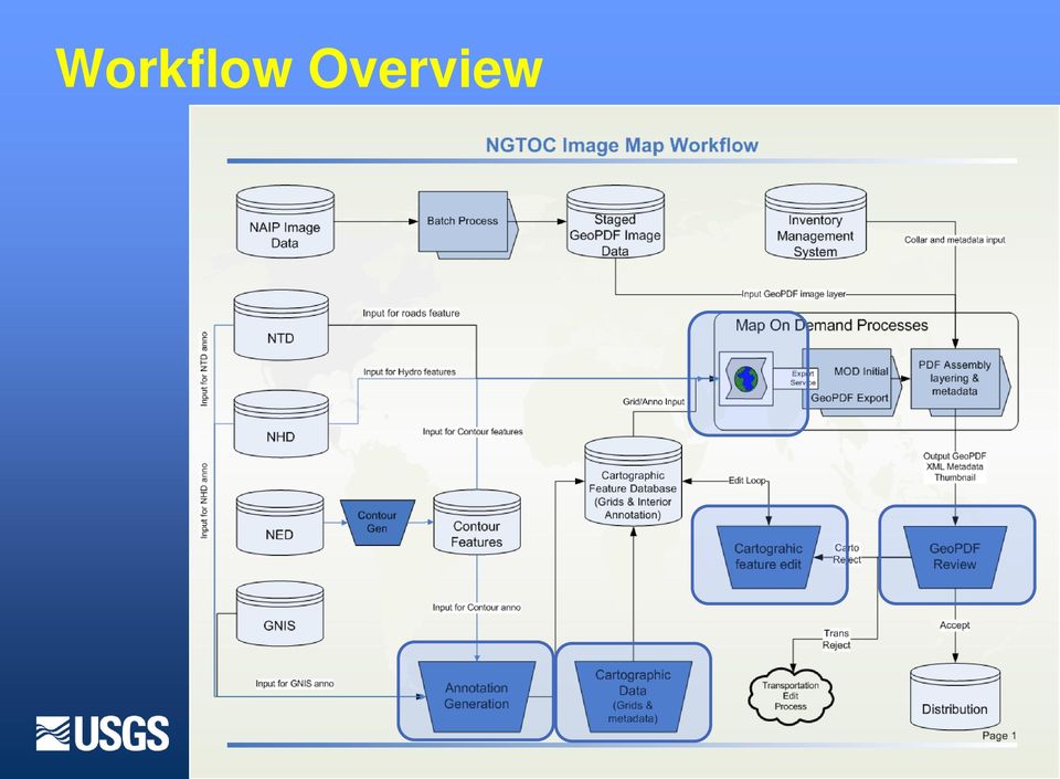
8 US Topo Production System Components ArcGIS (v 9.3.1) ArcMap Production Line Tool Set Job Tracking Extension Global Mapper ArcGIS Image Server ArcGIS Server TerraGo Technologies PDF Tron TerraGo Map Assembler Creation, editing and tracking of features Reference Information Creation of GeoPDF Metadata Assembly of final product

9 US Topo Production Data Components Image NAIP source nationally consistent 3 year planned cycle Transportation, Hydro and Contour Vectors TNM geodatabase sources (NTD, NHD, NED) GNIS, NHD, NTD & Contour Annotation Selected GNIS, NHD and NTD features Grids and Graticules Vectors and annotation labels created through PLTS Grid Manager Metadata FGDC compliant metadata attached to the GeoPDF

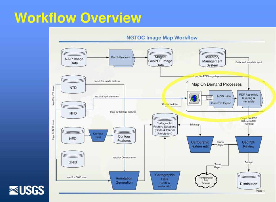
10 Workflow Overview
11 JTX Custom Step Example Process consistency Volume management Multi-user data management Effective Designed specific to the need 11

12 Workflow Overview
13 Past History - Print On Demand (POD) + ArcIMS front end C#.NET / ArcGIS Server back end Child software similar to NGA s EPODs

14 Map On Demand (MOD) Replaced ArcIMS front end Support for multiple ArcGIS services Support for batch jobs Job queue Added functionality Support additional export formats U.S. National Grid diagram PLTS grids Ancillary functions: status, tracking Scaled out hardware 4 dedicated servers 1 SOM (load balancing), 3 SOCs +

15 Limitations No external configurability Hardcoded parameters Tight coupling between components Poor error handling Obscure error messages Object reference not set to an instance of an object Errors lost or hidden 15

16 Consequences Difficult to support new requirements Arbitrary extents Off-center quads Non-standard dimensions Maps outside of the conterminous U.S. (Alaska, Puerto Rico, etc.) New versions of TerraGo New versions of ArcGIS ArcGIS Server Image Extension (Image Server) 16
 New versions of TerraGo New versions of ArcGIS ArcGIS Server")
17 17
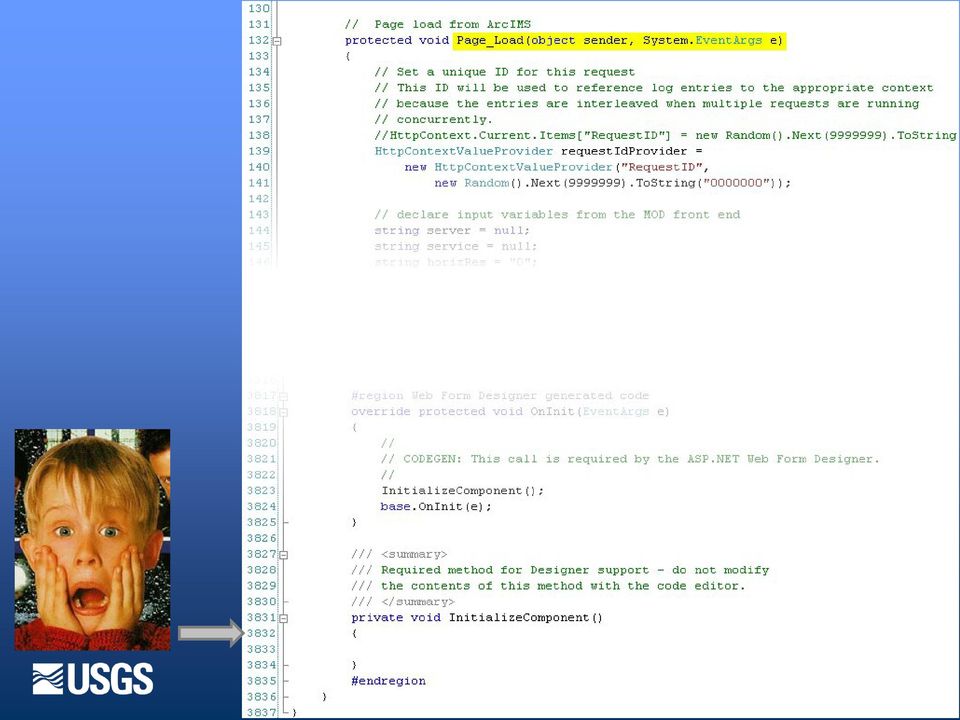
18 Developer 18

19 Map On Demand 2 (MOD2) Processing Engine Configurations MOD2.Core

20 Map On Demand 2 (MOD2) Business Logic

21 Map On Demand 2 (MOD2) Application Logic
22 Map On Demand (MOD) Components
23 User Interfaces 23
24 #1 Job Request
25 #1 - Job Queue (track status during creation)
26 #1 - Track production status
27 Map On Demand (MOD) Components
28 #2 Map Template (mxd)
29 Map On Demand (MOD) Components
30 #3 - Extent Service Well-defined, cell-based index Cell data are used to populate the map Set the map extent and projection. Format collar elements And are also included in the XML metadata embedded in the final product Data are static or changes infrequently, pre computed for each cell, exposed via web services
31 #3 - Extent Service Cell name and diacritic Bounds Geographic extent (NAD83) Projected extent (UTM) USNG data Citation dates Contour interval and unit County and state names SPCS zones
32 Map On Demand (MOD) Components
33 #4 Create GeoPDF Uses ArcGIS Server with customized C#.Net code Uses TerraGo export to generate GeoPDF Uses Image Server with NAIP image, 1 meter per pixel, added as layer
34 Map On Demand (MOD) Components
35 #5 Relayering pre-assembled pdf Mxd template post-assembled pdf
36 #5 Relayering Currently use PDF Tron and PDF Clown to relayer and attach metadata to GeoPDF By October 31, 2010, will use utility created by TerraGo Technologies Menu interface for product that doesn t change part of export configuration API for programmable on-the-fly layer additions/removals 36
37 Map On Demand (MOD) Components
38 #6 GeoPDF Product Production capacity with current configuration 40 quads per hour 900 quads per day Major constraint is acceptable data
39 GeoPDF Concerns Understand / Accept true purpose of GeoPDF Excellent plotting capabilities Viewing in free Adobe Reader Putting 5 lbs in a two lb bag? Phased feature additions - Woodland in Dec, 2010; Boundaries in Nov, 2010; Fire Stations, etc. compression limits reached; performance affected Additional functionality transparency, object data, 3D What is lifetime of GeoPDF format? Compromise between a GIS and a pretty picture Data round-trip Mobile possibilities Difficult to use in a GIS application
40 Thank you Questions Helmut Lestinsky USGS NGTOC 40