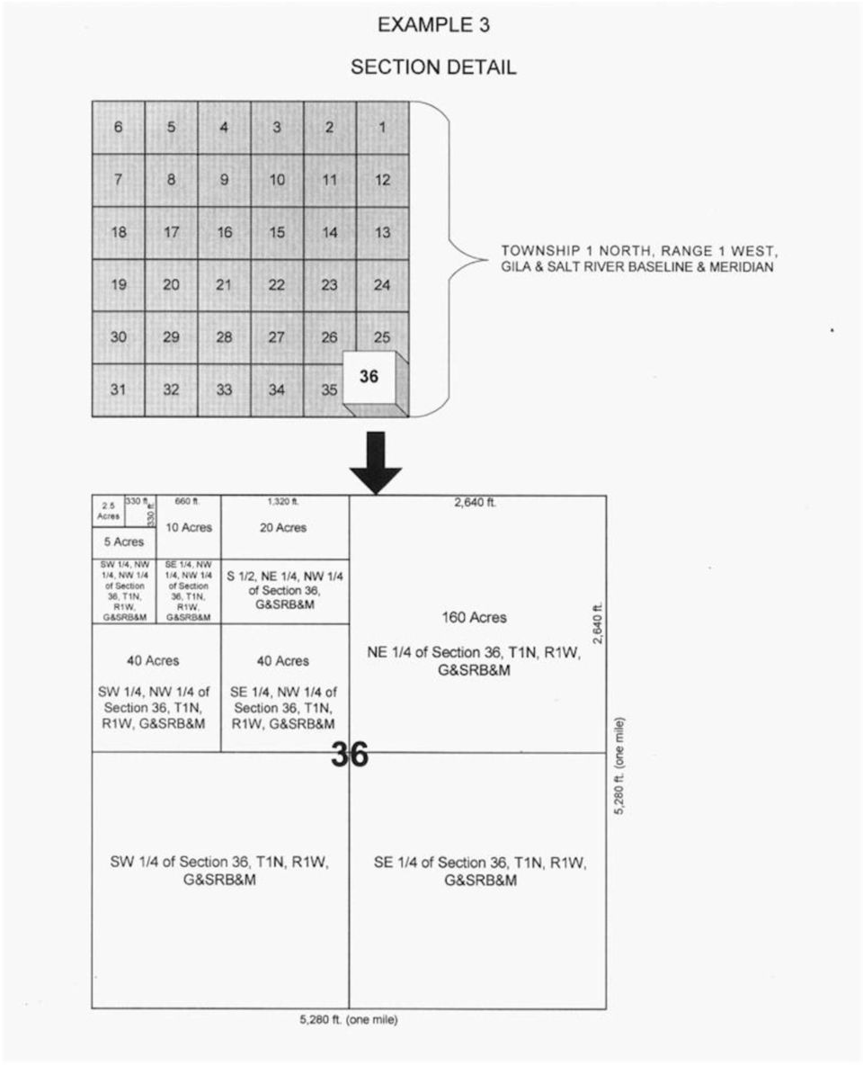
Rectangular survey System (Township and Rang System). Pg Designed to facilitate the movement of non-indians across the farmlands of the U.S.
|
|
|
- Jemimah McDowell
- 8 years ago
- Views:
Transcription
1 Rectangular survey System (Township and Rang System). Pg Designed to facilitate the movement of non-indians across the farmlands of the U.S. Does not take terrain into account.

2

3
4 Metes and Bounds In the original colonies, ownership of individual parcels of land was often established before the region was systematically surveyed. Parcels of land were described using key features of the landscape to describe the boundaries of the owned land. To legally describe (survey) this land later, each property line segment was surveyed and its compass direction (bearing) and length recorded> This metes and bounds surveying produced land ownership maps like the property shown in the figure below. Note that the compass directions are by convention listed as so many degrees east or west of north and south. Schematic example of a property described by a metes-and-bounds survey. Metes-and-bounds survey descriptions often use distinctive features as markers along the property boundary. For example, it might use a particular species of tree or distinctive rock outcropping. If you fly over portions of the United States, surveyed with the metes and bounds system, the patterns on the ground are highly irregular and lack the geometric, rectangular patterns characteristic of the western parts of the country. Long-Lot Survey The early French government tried to transplant a vestigial form of feudalism, the seigneurial system, to its possessions in Canada. It granted large acreages of land to seigneurs, who were expected to bring in tenants to settle and work the land. In return, the seigneur had certain feudal rights over his tenants: to receive token rent payments from them, to require them to use his mill for grinding their grain, to demand various work services from them. The feudal elements of this system quickly became irrelevant in the New World, where land was available in abundance for tenants who felt oppressed and wanted to move, but the long-lot system of land division associated with seigneuries remains vividly imprinted on the landscape of North America that were settled by French-speaking people. Long lots can be found in many parts of Canada, where the French influence is strong, and near Detroit (for the same reason).

5 The French settlers were more interested in the fur trade than they were in farming, and the seigneuries were laid out to give maximum access to the rivers that were the main routes to the interior. Each seigneury (or, long lot) had a fairly narrow frontage on the river, but extended far back from it. Each was subdivided into long narrow strips that were only 350 to 600 feet wide but ten times as deep. At the back end of the strips a road ran parallel to the general course of the river, and this road provided the frontage for a second range of strips when the first range was fully occupied. The long-lot system of land survey (below) was cheap and easy, and it gave each farm equal amounts of each kind of soil on the floodplain, the terraces, and the interfluves. It gave access to a transportation artery (river or road) for a maximum number of farms. Each family could live on its own farm but still be

6 close to neighbors. Each family developed its farm progressively, but clearing the forests near the farmstead first and leaving the more remote parts until later. Some farmers built isolated barns at the far ends of their farms to reduce the labor of hauling crops in to the farmstead and manure back out to the fields. The long-lot system of land survey has some disadvantages. Few rivers follow straight lines; the twists and turns of a meandering river complicated the survey, the "long lots" inside narrow bends were likely to be bobtailed, and considerable litigation was virtually inevitable if the river changed its course. One of the most serious drawbacks of the long-lot survey system was related to inheritance. Farms were split right down the middle when the owner died, and farms that were already narrow became far too narrow when they were divided equally among the children, especially when families were as large as they often are in French Canada. The image below is of an island in the St. Lawrence River; it is obvious from the photo that the island's land holdings were carved up using the long lot system.

7
8

GEOGRAPHIC INFORMATION SYSTEMS Lecture 11: Land Division Systems
 GEOGRAPHIC INFORMATION SYSTEMS Lecture 11: Land Division Systems Land Division Systems - in many applications of GIS, land ownership is an important data layer and it is important for GIS users to be familiar
About Fact Sheets Contact Us Partners Products Site Map FAQ Help
 About Fact Sheets Contact Us Partners Products Site Map FAQ Help Home Articles PLSS Article The Public Land Survey System (PLSS) What is the PLSS? History Commonly Used Terms Related Links What is the
FORMULA FOR FINDING THE SQUARE FEET OF A RECTANGLE L x W = A
 UNIT I REAL ESTATE MATH AREA MEASUREMENTS FORMULA FOR FINDING THE SQUARE FEET OF A RECTANGLE L x W = A Where: A = Area L = Length W = Width If the length = 30 and the width = 20 20 x 30 = 600 Sq. Feet
Chapter 9 Questions Legal Descriptions
 Chapter 9 Questions Legal Descriptions 1. How many acres are in a lot that is 1/4 of a mile wide by 1/4 of a mile long? a. 10 b. 120 c. 40 d. 80 2. The numbering of sections in a township begins in the
CULTURAL HISTORY The United States Public Land Survey System The Rectangular Grid By Neal McLain
 CULTURAL HISTORY The United States Public Land Survey System The Rectangular Grid By Neal McLain In last month's column, I discussed the origin of the United States Public Land Survey System (USPLSS, or
Legal Descriptions. Chapter 9
 Legal Descriptions Chapter 9 Legal Description Defined A description of land is legally sufficient if it allows a competent surveyor to locate the parcel. This means locate and define boundaries 2 When
UTM Zones for the US UTM UTM. Uniform strips Scalable coordinates
 UTM UTM Uniform strips Scalable coordinates Globally consistent, most popular projection/coordinate system for regional to global scale geospatial data (i.e. satellite images global scale datasets USGS/EDC)
THE APPRAISAL OF REAL ESTATE 3 RD CANADIAN EDITION BUSI 330
 THE APPRAISAL OF REAL ESTATE 3 RD CANADIAN EDITION BUSI 330 REVIEW NOTES by CHUCK DUNN CHAPTER 10 Copyright 2010 by the Real Estate Division and Chuck Dunn. All rights reserved ARE 3 rd EDITION REVIEW
Public Land Survey System - Definition
 Public Land Survey System - Definition The Public Land Survey System (PLSS) is a method used in the United States to locate and identify land, particularly for titles and deeds of farm or rural land. The
Mastering U.S. LEGAL DESCRIPTIONS
 www.landtraining.net Mastering U.S. LEGAL DESCRIPTIONS This FREE Webinar is offered by Midland College in collaboration with Alyce Hoge of Land Training. Alyce Hoge is the instructor for the Midland College
Rural Settlement Patterns
 Rural Settlement Patterns A summary with pictures. Courtesy of Crescent School There are three types of rural settlement patterns that occurred where large numbers of people settled: the long lots of
CHAPTER 4 LEGAL DESCRIPTION OF LAND DESCRIBING LAND METHODS OF DESCRIBING REAL ESTATE
 r CHAPTER 4 LEGAL DESCRIPTION OF LAND DESCRIBING LAND A legal description is a detailed way of describing a parcel of land for documents such as deeds and mortgages that will be accepted in a court of
Lesson 2: The Nature of Real Property. Real Property. Real Property. Real Estate Principles of Georgia. vs. Personal Property.
 Real Estate Principles of Georgia Lesson 2: The Nature of Real Property 1 of 53 23 Real Property vs. Personal Property Two types of property: Real property, ( realty ), real estate Personal property (
Finding Real Property: Legal Descriptions
 Finding Real Property: Legal Descriptions LEARNING OBJECTIVES Upon completion of this chapter, the student should be able to: Explain the importance of an accurate legal description. Relate the three methods
Basic Rectangular Surveys
 Basic Rectangular Surveys The Public Land Survey System What Are We Going To Talk About? The rectangular survey system How it is designed How the surveys were supposed to be performed Some unique aspects
Understanding Land Measurement and Legal Descriptions
 Lesson A2 1 Understanding Land Measurement and Legal Descriptions Unit A. Mechanical Systems and Technology Problem Area 2. Soil and Environmental Technology Systems Lesson 1. Understanding Land Measurement
Chapter 2: Europe Looks Outward. Chapter 2.4: France and the Netherlands in North America
 Chapter 2: Europe Looks Outward Chapter 2.4: France and the Netherlands in North America Section Focus Question What impact did the establishment of French and Dutch colonies in North America have on Native
Modern Real Estate Practice in Illinois, 6 th Edition Filmore W. Galaty, Wellington J. Allaway, Robert C. Kyle Laurie MacDougal, Consulting Editor
 Filmore W. Galaty, Wellington J. Allaway, Robert C. Kyle Laurie MacDougal, Consulting Editor Chapter 9 Review Quiz 1. The numbering of sections in a township begins in the section in the a. northeast corner
CHAPTER 8 - LAND DESCRIPTIONS
 CHAPTER 8 - LAND DESCRIPTIONS Notes: While the location of land is commonly referred to by street number and city, it is necessary to use the legal description in the preparation of those instruments relating
Tax Parcel Mapping. Visual Representations of Legal Descriptions and So Much More
 Tax Parcel Mapping Visual Representations of Legal Descriptions and So Much More Topics I. E-Distribution II. GIS & Tax Mapping III. Tax Mapping Procedures IV. Deeds, Property Descriptions, & You! I. E-Distribution
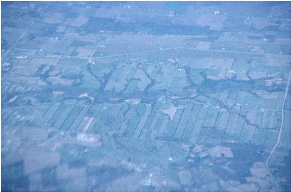
Agriculture. Thursday, January 09, 2014 11:58 AM. Unfiled Notes Page 1. Valley, Oregon.
 Unfiled Notes Page 1 Agriculture Thursday, January 09, 2014 11:58 AM What Imprint Does Agriculture Make on the Cultural Landscape? Flying from the West Coast of the United States to the East Coast, if
PART VI: BOUNDARY SURVEYING
 PART VI: BOUNDARY SURVEYING 6.1 The U.S. Rectangular Survey System (Overview) The Public Land Survey System in Michigan is referenced to two axes. The North and South axis is the Michigan Principal Meridian
Part 5 U.S. Public Land Survey System
 National Mapping Program Technical Instructions Part 5 U.S. Public Land Survey System Standards for 1:24,000-Scale Digital Line Graphs-3 Core U.S. Department of the Interior U.S. Geological Survey National
Visualizing Metes and Bounds Property Descriptions on Google Maps and Google Earth
 Visualizing Metes and Bounds Property Descriptions on Google Maps and Google Earth Presented by James L. Tanner Genealogy's Star http://genealogysstar.blogspot.com New online tools allow you to identify
GENERAL MATH PROBLEM CATEGORIES AND ILLUSTRATED SOLUTIONS MEASUREMENT STANDARDS WHICH MUST BE MEMORIZED FOR THE BROKER TEST
 Chapter 17 Math Problem Solutions CHAPTER 17 GENERAL MATH PROBLEM CATEGORIES AND ILLUSTRATED SOLUTIONS MEASUREMENT STANDARDS WHICH MUST BE MEMORIZED FOR THE BROKER TEST Linear Measure 12 inches = 1 ft
Indiana Farm Fence Laws
 PURDUE EXTENSION EC-657 Legal Affairs Indiana Farm Fence Laws Agricultural ECONOMICS Gerald A. Harrison Purdue Extension Economist Paul D. Spillers Member of the Bar, State of Louisiana Introduction Many
VISUAL 6.1 GREAT BRITAIN S AMERICAN COLONIES
 SPECIALIZATION AND TRADE IN THE THIRTEEN COLONIES LESSON 6 VISUAL 6.1 GREAT BRITAIN S AMERICAN COLONIES GREAT BRITAIN S COLONIES All colonies are rich in natural resources but short on labor. PRODUCTIVE
Research verification coordinators collaborate with Arkansas Division of Agriculture crop specialists to determine a typical production method for
 1 2 3 Research verification coordinators collaborate with Arkansas Division of Agriculture crop specialists to determine a typical production method for application in the crop enterprise budgets. 4 Whole
Pennsylvania's Clean and Green Program
 Pennsylvania's Clean and Green Program The Penn State Dickinson Agricultural Law Resource and Reference Center * The purpose of this publication is to help you learn about and understand this important
www.pdhcenter.com PDH Course L118 www.pdhonline.org Basic Public Lands Jan Van Sickle, PLS
 Basic Public Lands Jan Van Sickle, PLS From the very beginning of the Public Land Surveying System it has always been the policy of the Federal Government that land in the public domain must be surveyed
Lower Your Property Taxes With Clean And Green
 Monday, October 22, 2001 The Agricultural Law Research & Education Center Lower Your Property Taxes With Clean and Green Page 1 Lower Your Property Taxes With Clean And Green This information will be updated
State Land States vs. Public Land States
 Public Lands Survey System Rectangular Survey System Sections, Ranges, Townships Roberta Bobbi King Lakewood, Colorado State Land States vs. Public Land States State Land States: Metes and bounds twenty
CONTENTS ABSTRACT. KEYWORDS:. Forest ownership, forest conversion.
 CONTENTS INTRODUCTION... Page PHYSICAL CHANGES IN COMMERCIAL FOREST AREA... 4 Nearly 1 million acres have been lost since 1945... 4 Road construction was leading cause of forest loss in the two states...
APPLICATION FOR CLASSIFICATION OF FOREST LAND
 To the Chief, Division of Forestry: APPLICATION FOR CLASSIFICATION OF FOREST LAND In accordance with sections 5713.22-.26 of the Ohio Revised Code, I hereby apply for the classification of certain lands
Repair of Fences Damaged by Bushfire and Fire Control Line Rehabilitation Policy
 Repair of Fences Damaged by Bushfire and Fire Control Line Rehabilitation Policy Contents Contents 1 1.0 Purpose 2 1.1 Background 2 1.2 Purpose 2 2.0 Scope 2 3.0 Principles / Policy 3 3.1 Damage to private
STATE OF ALASKA DEPARTMENT OF NATURAL RESOURCES DIVISION OF MINING, LAND AND WATER. GENERAL SURVEY INSTRUCTIONS EASEMENTS Authority 11 AAC 53
 STATE OF ALASKA DEPARTMENT OF NATURAL RESOURCES DIVISION OF MINING, LAND AND WATER GENERAL SURVEY INSTRUCTIONS EASEMENTS Authority 11 AAC 53 These instructions define the survey and platting criteria unique
1161.01 CONFORMITY WITH PLANS; DRAINAGE.
 CHAPTER 1161 Subdivision Requirements 1161.01 Conformity with plans; drainage 1161.07 Easements 1161.02 Trees 1161.08 Streets 1161.03 Subdivision name 1161.09 Blocks 1161.04 Street names 1161.10 Lots 1161.05
Chapter 4: How To Do A Title Search
 Chapter 4: How To Do A Title Search Introduction Title searching answers questions about property ownership, sale prices, mortgages, liens, and court cases. Although a "how to" narrative cannot replace
WESTFIELD-WASHINGTON ADVISORY PLAN COMMISSION December 7, 2015 1512-SPP-24 & 1512-ODP-24
 Petition Number: Subject Site Address: Petitioner: Request: East side of Oak Road, north of 151 st Street Langston Development Co. Primary Plat and Overall Development Plan amendment review for Mapleridge
Survey of the Louisiana Purchase in 1815
 Lesson Strategy for the Louisiana Purchase Bicentennial Instructor Copy Survey of the Louisiana Purchase in 1815 Grades: 4-12 Suggested Time Frame: Two, 50-minute class periods Objectives: To understand
M. Geesaman, Instructor Last revised: 2-26-02 The Origin and Development of the Rectangular Survey System
 M. Geesaman, Instructor Last revised: 2-26-02 The Origin and Development of the Rectangular Survey System Colorado falls into two main surveys. The 6 th Principal Meridian Survey and the New Mexico Principal
ELECTRIC TRANSMISSION LINE CONSTRUCTION STANDARDS AND POLICIES
 ELECTRIC TRANSMISSION LINE CONSTRUCTION STANDARDS AND POLICIES Recommended by the Illinois Department of Agriculture The following electric line construction standards and policies are recommended by the
Weekend Cabin Retreat Project Site Plans
 Weekend Cabin Retreat Project Site Plans Sacramento City College EDT 300/ENGR 306 EDT 300/ENGR 306 - Site Plans 1 Cabin Project Site Plan/Bubble Diagram - Assignment 1 =10-0 Floor Plan - Assignment 1/4
ALASKA NATIVE CLAIMS SETTLEMENT ACT (PL 92-203)
") ALASKA NATIVE CLAIMS SETTLEMENT ACT (PL 92-203) The attached information is intended to be a short overview of the history and requirements of the Alaska Native Claims Settlement Act. There are many other
ALASKA NATIVE CLAIMS SETTLEMENT ACT (PL 92-203) The attached information is intended to be a short overview of the history and requirements of the Alaska Native Claims Settlement Act. There are many other
Corridor Goals and Objectives
 Corridor Goals and Objectives This chapter presents the goals and objectives, developed by the Corridor Study Committee, that serve as the purpose and intent of the Corridor Plan. This plan covers a twenty
Wind power in Denmark 1
 June 1996 Peter Helby Wind power in Denmark 1 A sketch of history. Wind power always fascinated the Danes. The geography of the country made Denmark a sea going nation with a large merchant fleet and lots
NATURAL RESOURCES & NATURAL FEATURES
 A3 NATURAL RESOURCES & NATURAL FEATURES INTRODUCTION This chapter will discuss the topography, geology, soils, and other natural features found in Casco Township. The identification of the natural features
Nature and Description of Real Estate
 Nature and Description of Real Estate Real Estate (Real Property): land and improvements made to land rights to use them NAVAPA V. 5615254 Land: start at center of the earth passes through earth s surface
Outline. The Atlantic Northeast and French Canada. Atlantic Northeast Defining the Region. Atlantic Northeast Defining the Region
 The and Outline 1. The 2. and Overarching Themes Defining the Region What s the unique characteristic? Less explicit than other unique characteristics Character, rurality, not French, relatively limited
Monitoring Riparian Areas With a Camera
 Monitoring Riparian Areas With a Camera By Michael DeLasaux 1, Holly George 2, and Philip Mainwaring 3 Riparian areas are next to streams, springs, rivers, ponds and lakes. Physical characteristics that
ELEMENTS OF SURVEYING FOR CADASTRAL MAPPING
 ELEMENTS OF SURVEYING FOR CADASTRAL MAPPING Chapter 4 2015 Cadastral Mapping Manual 4-0 Elements of Surveying and Mapping Utah's system of land surveying is the rectangular survey system as set forth on
2Legal Considerations
 C h a p t e r T w o 2Legal Considerations in Appraisal LEARNING OBJECTIVES Students will be able to 1. recognize the important legal considerations that affect real estate appraisal. 2. define and understand
Estimating Cash Rental Rates for Farmland
 Estimating Cash Rental Rates for Farmland Tenant operators farm more than half of the crop land in Iowa. Moreover, nearly 70 percent of the rented crop land is operated under a cash lease. Cash leases
PART 1 - REAL ESTATE BASICS
 PART 1 - REAL ESTATE BASICS Table of Contents Page 1.1 Ownership Concepts and Interests in Land 1 1.1.1 Fee Simple 1 1.1.2 Life Estate 1 1.1.3 Leasehold Interest 2 1.1.4 Common Law Easements 2 1.1.5 Restrictive
Il.oma. s lv,lfo... csl P«.pid B... t..f. Gco. s".,!it. 2 t-+----rt .141, ..:Ioia"~n '60. f7hil,~~ fc'lhe.r; {r; ZIIO
 Il.oma. s lv,lfo... csl P«.pid B... t..f Gco. s".,!it 2 t-+----rt go.141,..:ioia"~n '60 f7hil,~~ fc'lhe.r; {r; ZIIO A DEQUATE legal descriptions are essential in many types of legal J-\... instruments
Title 7. Agriculture. Part V-C Farmland and Forest. Land Assessments. Chapter 137. Preferential. Assessment of Farmland and.
 Title 7. Agriculture Part V-C Farmland and Forest Land Assessments Chapter 137. Preferential Assessment of Farmland and Forest Land Clean & Green Rules & Regulations Tioga County Courthouse 118 Main Street
Chapter 10: How Americans Settled the Frontier. The white settlers moving west into land that Native Americans lived : westward expansion.
 Chapter 10: How Americans Settled the Frontier Multiple Perspectives and the Idea of a Frontier Frontier : The land west of where most white settlers lived. Native Americans lived on the frontier. The
Waterfront Property: Do You Own it?
 Waterfront Property: Do You Own it? By Brian Madigan LL.B. If you are looking at waterfront property, you really want to know where your property ends and the lake begins. You definitely don t want a gap.
Application by National Grid Gas plc for the River Humber Gas Pipeline replacement (the application)
") Application by National Grid Gas plc for the River Humber Gas Pipeline replacement (the application) Examining Authority s (ExA) Record of Unaccompanied Inspection of Sites to Which the Application or
Application by National Grid Gas plc for the River Humber Gas Pipeline replacement (the application) Examining Authority s (ExA) Record of Unaccompanied Inspection of Sites to Which the Application or
LAND SURVEYING PROGRAM QUESTIONS AND ANSWERS
 LAND SURVEYING PROGRAM QUESTIONS AND ANSWERS Written by Dennis J. Mouland, P.L.S., Regional Surveyor Southwest Region Originally compiled by Joan L. Fritz, Land Surveys, Idaho Panhandle National Forest
Mapping & Agricultural Manual
 State of Wyoming Department of Revenue 122 West 25th Street Cheyenne, Wyoming 82002-0110 Foreword The increasing need for land information, at all levels of government and in the private sector, has resulted
Agricultural ecology. influence on different forms of agriculture. ! Cultural adaptation! How weather and climate probably exert the greatest
 Agricultural ecology! Cultural adaptation! How weather and climate probably exert the greatest influence on different forms of agriculture! Cultivation of frost-sensitive crops is very expensive outside
Adjusting GIS Data to the GCDB
 Best Practice Recommendations Adjusting GIS Data to the GCDB Montana Base Map Service Center August 2008 This document was prepared for the State of Montana GIS Base Map Service Center, by DJ&A, P.C. in
Ouachita River Floodplain Restoration Upper Ouachita NWR, Louisiana
 Ouachita River Floodplain Restoration Upper Ouachita NWR, Louisiana Interior Hydrologic Restoration Plan Mollicy Farms Unit The Nature Conservancy Louisiana Field Office 2011 Cover: Sediment laden water
Discovering World Geography WESTERN HEMISPHERE
 WESTERN HEMISPHERE Follow Lesson Correlations for Instructional strategies that encourage the development of critical thinking, problem solving and performance skills. Custom Book: Student Edition REFERENCE
WEATHERING, EROSION, AND DEPOSITION PRACTICE TEST. Which graph best shows the relative stream velocities across the stream from A to B?
 NAME DATE WEATHERING, EROSION, AND DEPOSITION PRACTICE TEST 1. The diagram below shows a meandering stream. Measurements of stream velocity were taken along straight line AB. Which graph best shows the
FILE NO.: Z-6915-C. Gamble Road Short-form PCD and Land Alteration Variance Request
 FILE NO.: Z-6915-C NAME: Gamble Road Short-form PCD and Land Alteration Variance Request LOCATION: Located on the Northwest corner of Chenal Parkway and Gamble Road DEVELOPER: Davis Properties P.O. Box
Farmland Lease Analysis: Program Overview. Navigating the Farmland Lease Analysis program
 Farmland Lease Analysis: Program Overview The farmland lease analysis program is used to aid tenants and landlords in determining the returns and risks from different farmland leases. The program offers
WATER AND SEWER LINE CONSTRUCTION STANDARDS AND POLICIES
 WATER AND SEWER LINE CONSTRUCTION STANDARDS AND POLICIES Established by the ILLINOIS DEPARTMENT OF AGRICULTURE The following standards and policies will serve to minimize the negative agricultural impacts
LOW INTEREST LOANS FOR AGRICULTURAL CONSERVATION
 LOW INTEREST LOANS FOR AGRICULTURAL CONSERVATION LILAC MANUAL LOW INTEREST LOANS FOR AGRICULTURAL CONSERVATION TABLE OF CONTENTS Introduction... 3 General Eligibility... 4 Specific Eligibility Criteria
Personal Study Assignment #1: Inventory Assessment
 The purpose of this activity is for you to conduct an inventory of your farm business assets. Think about your farm business and list all of the assets you own and/or control that make up the farm business.
Settlement of Foundations on Expansive Clays Due to Moisture Demand of Trees CIGMAT 2008
 Settlement of Foundations on Expansive Clays Due to Moisture Demand of Trees CIGMAT 2008 Kenneth E. Tand, P.E. Practicing Geotechnical Engineer FRIEND OR FOE Trees are our friends. They extract carbon
PROCEDURES FOR COMPLETING LEGAL DESCRIPTIONS AND BOUNDARY MAPS
 PROCEDURES FOR COMPLETING LEGAL DESCRIPTIONS AND BOUNDARY MAPS A. Statutory Requirement. In 1970 Congress established the first wilderness within a national park system area. That law required that the
Michigan Department of Natural Resources Oil and Gas Leases Frequently Asked Questions
 What is the DNR s authority for leasing oil and gas? How are state-owned oil and gas rights leased? Who decides which state-owned oil and gas rights will be offered for lease at the auction? How often
I I I I I I. 8. Encourage equitable taxation and assessment policies for
 6. Encourage the establishment of appropriate Agriculture Security Areas, under Act 43, as amended, consistent with local and county Comprehensive Plans. Care should be taken not to designate farmland
Subject Property Subject Property OFFERING MEMORANDUM
 Subject Property Subject Property Subject Property OFFERING MEMORANDUM Listing Broker: Common Capital Partners, Inc. 3487 NE 163RD Street North Miami Beach, FL 33160 T: (305) 949-9191 F: (305) 949-9131
Negotiating Pipeline Easements
 FACT SHEET Ohio State University Extension, 2120 Fyffe Road, Columbus, OH 43210 Introduction Shale Oil and Gas Development Fact Sheet Series Negotiating Pipeline Easements Peggy Kirk Hall Director, OSU
FREQUENTLY ASKED QUESTIONS...
 A Legal Guide to Plan Farmland Ownership in Manitoba The surest way to reach a business goal is to plan on it. Successful Manitoba farmers are focused business people. They have clear, flexible, short
Chapter 18 Introduction to. A f r i c a
 Chapter 18 Introduction to A f r i c a Ch. 18:1 Landforms & Resources 1. Africa s shape & landforms are the result of its location in the southern part of the ancient supercontinent of. Pangaea Over thousands
Each Day is scheduled for a block/90 minute class. 45/50-minute classes would split the lesson into two parts.
 Agriculture Unit Plan Intro Page Charlie Henry 9 th Grade-AP Human Geography Each Day is scheduled for a block/90 minute class. 45/50-minute classes would split the lesson into two parts. The last two
FUR TRADE PHASE 1 The Early Fur Trade 1500-1603 A Glimpse of the Early Fur Trade
 FUR TRADE PHASE 1 The Early Fur Trade 1500-1603 The cod fishery began the early fur trade. First Nations such as the Mi kmaq began to trade with Europeans coming to fish cod off the east coast. The British
FOR SALE. TWIN CREEKS VINEYARD 14151 & 14777 East Liberty Road Lodi, CA * A ZERO CASH FLOW TAX ORIENTED SALE * Asking Price $ 5,335,600
 FOR SALE TWIN CREEKS VINEYARD 14151 & 14777 East Liberty Road Lodi, CA * A ZERO CASH FLOW TAX ORIENTED SALE * Asking Price $ 5,335,600 Initial Down Payment $ 2,685,600 Capitalization Rate 8% First Year
New Jersey s Farmland Assessment Act. An Informational Guide on Basic Requirements
 New Jersey s Farmland Assessment Act An Informational Guide on Basic Requirements Prepared by the New Jersey Department of Agriculture in consultation with the New Jersey Division of Taxation and the New
International Boundary Study. China Hong Kong Boundary
 International Boundary Study No. 13 April 13, 1962 China Hong Kong Boundary (Country Codes: CH-HK) The Geographer Office of the Geographer Bureau of Intelligence and Research INTERNATIONAL BOUNDARY STUDY
Searching Land Records thru the BLM General Land Office Records.
 Searching Land Records thru the BLM General Land Office Records. Land Records can be an exciting addition to your family history search. The United States Government transferred ownership of land to millions
Using Aerial Photography to Measure Habitat Changes. Method
 Then and Now Using Aerial Photography to Measure Habitat Changes Method Subject Areas: environmental education, science, social studies Conceptual Framework Topic References: HIIIB, HIIIB1, HIIIB2, HIIIB3,
USA s First President Surveyor George Washington
 USA s First President Surveyor George Washington Donald BUHLER Key words: History, Surveyor, Washington, Public Land Survey System SUMMARY From a historical standpoint, George Washington is the most famous
Standard Surveying Terms
 Standard Surveying Terms Aliquot - The description of fractional section ownership used in the U.S. public land states. A parcel is generally identified by its section, township, and range. The aliquot
1 Welcome. The exhibition comprises a series of boards which provide some background information to show you our initial ideas for the site.
 1 Welcome Thank you for taking the time to attend this public exhibition of our proposals for residential development on Land at Daws Farm, Back Road, Writtle (site shown opposite). The exhibition comprises
Emergency Conservation Program
 Materials Prepared for Federation of Southern Cooperatives Epes, Alabama September 11, 2009 Emergency Conservation Program by Karen R. Krub Farmers Legal Action Group, Inc. 360 North Robert Street, Suite
is pleased to offer via Sealed Bid Sale
 is pleased to offer via Sealed Bid Sale 21.164 +/- ACRES IN FULTON COUNTY, IL GORSUCH-HENSLEY REAL ESTATE & AUCTION, INC. 1050 North Main Street Canton, IL 61520 309.647.8811 Phone 309.649.5469 Fax www.gorsuch-hensley.com
Keystart Home Loan Product Guide Dated February 2013
 Keystart Home Loan Product Guide Dated February 2013 Keystart Loans Ltd ABN 27 009 427 034 Australian Credit Licence 381437 1 Contents About this booklet 3 Keystart Home Loan 4 SharedStart Home Loan 6
Title 10 DEPARTMENT OF NATURAL RESOURCES Division 35 Land Survey Chapter 1 Cadastral Mapping Standards
 Title 10 DEPARTMENT OF NATURAL RESOURCES Division 35 Land Survey Chapter 1 Cadastral Mapping Standards 10 CSR 35-1.010 Application of Standards PURPOSE: These minimum standards provide the digital mapper
LEGAL DESCRIPTIONS INTRODUCTION
 LEGAL DESCRIPTIONS INTRODUCTION Legal descriptions, as the name implies, are the way and means by which real property, or real estate, is legally identified, conveyed, assessed and taxed. To put this into
Finding a Farm to Buy or Lease Resource Kit for Nova Scotia Farmers
 1 Finding a Farm to Buy or Lease Resource Kit for Nova Scotia Farmers Helpful Contacts for Buying a Farm Your local Agricultural Resource Coordinator (ARC) may know of farms for sale or rent in your area.
Basic Farming Questions What did you grow on the farm when you first started? Are you a first generation farm owner or has your family been in
 MASTER LIST OF POSSIBLE QUESTIONS FOR FARMER INTERVIEWS: Choose a subset of 15-20 of these questions and have them ready in case the conversation hits a slow spot. Personal History When did you start farming?
China The Giant Panda
 China The Giant Panda China The Giant Panda Deep in a forest, a black-and-white bear sits peacefully. It chews the green leaves of a plant. The bear is alone, but there are others not too far away. Later,
Keystart Home Loans Product Guide
 Keystart Home Loans Product Guide September 2013 Keystart Loans Ltd ABN 27 009 427 034 Australian Credit Licence 381437 1 Contents About this booklet 3 Keystart home loan 4 SharedStart home loan 6 Aboriginal
Kentucky ANR Agent Land Value and Cash Rent Survey AEC 2013-16 Greg Halich and Karen Pulliam
 Kentucky ANR Agent Land Value and Cash Rent Survey AEC 2013-16 Greg Halich and Karen Pulliam In the first half of 2013, Agriculture and Natural Resource (ANR) agents were surveyed to estimate land values
Beyond Property Lines
 Beyond Property Lines Instructor: Sam Kain Thursday, September 27 You will receive one hour of continuing education for this session. Attendance is taken by scanning your name badge at the beginning of