Black-tailed Prairie Dog Conservation Plan. Approved 08/31/2010, Metro District Board of Directors
|
|
|
- Franklin Malone
- 8 years ago
- Views:
Transcription
1 Black-tailed Prairie Dog Conservation Plan Approved 08/31/2010, Metro District Board of Directors

2 Table of Contents Introduction...3 SECTION 1 SECTION 2 SECTION 3 SECTION 4 SECTION 5 SECTION 6 SECTION 7 Prairie Dogs: A key species facing declining numbers...3 Urban/Suburban Settings, Fragmented Ecosystems...4 Rural Settings, Contiguous Ecosystems...4 Open Space Management Goals: Managing healthy natural systems...5 Prairie Dog Conservation Guidelines...5 Managing a Prairie Dog Colony...6 Property Acceptance...7 Management Action Protocol...8 Long-Term Management Areas for Prairie Dogs: Using a Suitability Index...11 Community Participation / Education...12 Monitoring and Evaluation...13 Prairie Dog Colony Sites...13 a) Designated Suitable Habitat Areas for Prairie Dogs in b) Designated Unsuitable Habitat Areas for Prairie Dogs in c) Designated Unsuitable Habitat Areas for Prairie Dogs in References...18 Prairie Dog Information Sites...19 Page 2
 Designated Suitable Habitat Areas for Prairie Dogs in 2010.")
3 Black-tailed Prairie Dog Conservation Plan Residents of Highlands Ranch and most Coloradans love wildlife and enjoy having opportunities to see nature close at hand. Highlands Ranch, with its integral system of natural areas and nearby 8,200-acre Conservation Area, residents are well situated to view wildlife such as songbirds and hawks, deer and elk, rabbits, and several colonies of prairie dogs. Black-tailed prairie dogs are most commonly found in the upland natural areas of Highlands Ranch. They are a keystone species as their burrows provide homes for many other species of wildlife and they are a food source for many predators. Having prairie dogs living close to where many people live and work can present challenges for both animals and people. If residents are going to be able to continue seeing prairie dogs and the other wildlife species that depend on them, and if conflicts with people are to be reduced, then prairie dogs must be carefully managed. This management process hopes to enhance and maintain ecological diversity in natural areas and will help shift the distribution of prairie dogs towns, so that they only remain in suitable areas. This plan was created as a guide to conserving prairie dogs while maintaining healthy ecosystems that provide for a multitude of wildlife in Highlands Ranch. The plan also details steps that the Highlands Ranch Metro District will take to conserve prairie dogs and work to reduce conflicts with people. SECTION 1 Prairie Dogs: A key species facing declining numbers Black-tailed prairie dogs (Cynomys ludovicianus) are native to the Great Plains of North America and are considered an important species in the natural short grass prairie ecosystems. They are considered an integral part of the food chain for predators such as coyotes, foxes, raptors, and the endangered black-footed ferret. Prairie dog burrows often provide homes for burrowing owls, cottontail rabbits, rattlesnakes, and tiger salamanders, to name a few. Over the past several decades, however, the number of prairie dogs has declined as their habitat has been displaced by development and agriculture. With the development of houses, roads, and parks in Highlands Ranch, natural areas have become fragmented, including those that are home to prairie dogs. Not all of these remnant natural areas are large enough or otherwise suitable for sustaining prairie dogs. This plan outlines steps to reduce human/animal conflicts, while maintaining prairie dogs on suitable sites that sustain species and ecological diversity. Over time colonies on sites that are poorly suited will be shifted to more suitable sites and all colonies will be carefully managed. Page 3

4 The following outlines the differences between prairie dog colonies in urban settings such as Highlands Ranch, and more rural settings with contiguous ecosystems. Urban/Suburban Settings, Fragmented Ecosystems Prairie dogs live in small, narrow and fragmented habitat blocks, surrounded by development, which often results in: Insufficient predators, such as coyotes, hawks, and eagles, to keep in balance expanding numbers of prairie dogs. Few nearby areas for expanding populations to colonize, leading to populations exceeding carrying capacity of the land. Degradation of natural resources. Less contribution to other wildlife from prairie dog burrows. Close contact with humans and damage to private and public property often requires management. Urban colony sites provide education and viewing opportunities for many species of wildlife. Rural Settings, Contiguous Ecosystems Prairie dogs live in large, contiguous prairie ecosystems free of most barriers, which may result in: Sufficient predators to control prairie dog populations. Adequate area for natural dispersal, helping keep carrying capacities in check. Increased plant diversity. Burrows and natural changes to landscape by prairie dogs having beneficial role in a natural prairie ecosystem. Limited contact with humans and minimal destruction of private property, management is dependent on land use designation. Page 4

5 SECTION 2 Open Space Management Goals: Managing healthy naturals systems The Highlands Ranch open space system integrates natural open space areas, trail corridors and wildlife corridors within the larger community. While providing suitable habitat for many species of wildlife, most of these natural areas also function as part of the urban drainage system, helping to reduce the risk of flooding. The primary overall goals of the Metro District in managing the open space are: 1. To manage designated open space areas as natural systems, encouraging and enhancing healthy balanced ecosystems. 2. To manage outdoor recreation activities that occurs in open space to ensure that they are safe, enjoyable, and have minimal impact on natural resources. 3. To manage open space as a storm drainage system to prevent erosion, control runoff and enhance riparian/wetland areas. Detailed information about the Metro District Open Space Vision, Goals and Strategic Actions can be reviewed in Highlands Ranch Outdoors, located on the Metro District s web site at SECTION 3 Prairie Dog Conservation Guidelines In accordance with the Metro District Open Space management goals, prairie dog populations will be conserved with the following objectives: minimize health or safety hazards manage natural areas for species and ecosystem diversity maintain healthy prairie dog colonies minimize damage to public and private property minimize possibilities for future conflicts between prairie dogs and humans Page 5

6 Managing a Prairie Dog Colony The following guidelines will be used to determine when it is appropriate to manage a given situation. Combinations of these factors will always be considered when determining the need to manage prairie dogs. 1. Prairie dog population exceeds carrying capacity and/or results in destruction of natural resources When there is 20% bare ground within a colony s boundary, this indicates the carrying capacity within that specific geographic area may have been met or exceeded. If the population exceeds 50 prairie dogs per hectare (20 per acre), this is also a good indicator that the carrying capacity may have been exceeded in an area (Seery 1997). Site-specific analysis will determine if natural resources are being destroyed. When prairie dog populations exceed carrying capacities, the prairie dogs are subjected to increased stress. The lack of predators, high levels of outdoor recreation use of open space, and conflicts with adjacent residential and commercial properties, dictate that prairie dog populations (located in suitable sites as defined in Section 4), be best managed at 80% or less of the carrying capacity for that specific site. 2. Sustaining private and landscaped property and trail buffer zones Burrows and prairie dogs located within 50 feet of private property or landscapes areas, within six feet of trails, and associated burrows displaying above ground evidence of habit trails leading to private property or trails, will be routinely removed as an ongoing management activity, using the most cost effective means available, without public notification. 3. Human Health Hazard Prairie dog colonies will be closely monitored by Metro District Open Space staff for evidence of plague or other communicable disease. If any evidence is noted, it will be reported to the Tri-County Health Department, Colorado Department of Public Health and Environment, and the Colorado Division of Wildlife. 4. Noxious weed invasion of prairie dog towns Prairie dog colonies, which can present ideal conditions for noxious weed growth, will be inventoried, monitored and treated on a regular basis to minimize noxious weed invasion. Mowing, trimming, removal of weeds and other mechanical control methods will be the primary means of eradicating noxious weeds in and around prairie dog towns. Use of herbicides will be considered on a case-by-case basis after consulting with the Colorado Division of Wildlife and the Douglas County Weed Inspector. The District s Integrated Pest Management Plan can be viewed on the Metro District s web site at Page 6

7 5. Planned Development Removing or relocating a prairie dog colony from Metro District s properties, when deemed necessary by staff, may occur up to one year before an area is developed or slated for any construction activity including trails, parks, and utility improvements. Where there is a high risk that the area will be re-inhabited by nearby colonies, the colony will be removed as late as possible before construction. Where risk of recolonization is low, early removal of the colony is preferred. 6. Passive Management Increased natural predation of prairie dogs will be promoted by enhancing natural diversity by developing a seed mix of taller grasses for areas in and adjacent to prairie dog colonies, and by enhancing wildlife corridors and riparian areas where feasible. Predation by raptors will be encouraged by planting trees in wetter areas and installing artificial perch sites where needed. Natural barriers made of earthen berms planted with tall grasses and shrubs will be used as barriers where appropriate and sustainable. Staff will discourage human and pet contacts with prairie dogs through educational contacts, appropriate signage and by incorporating this topic into the District s Outdoor Education Program. Property Acceptance Using the criteria outlined in this section, properties being conveyed to the Metro District will be evaluated and designated as suitable or unsuitable (see Section 4) for meeting the Metro District s long-term goals for prairie dog conservation. If a site is designated as unsuitable, prairie dogs inhabiting that site must be removed before that property is accepted by the Metro District and the cost of their removal may be paid by the landowner or developer to the Metro District, who will carry it out. If the landowner will be carrying out the removal, the District will work with the landowner to determine the most appropriate means of removal, to obtain required permits, and to identify possible relocation sites. All costs incurred with prairie dog removal (e.g., public meetings, trapping, fumigation, permits, etc.) will be the responsibility of the landowner or developer. Page 7

8 Management Action Protocol As outlined in the Guidelines for Managing a Prairie Dog Colony; to encourage natural predation of prairie dogs, the Metro District will continue to create features such as natural barriers, artificial raptor perches, tree plantings for future raptor perches, and other plantings to provide additional cover for predators. At times prairie dog towns will need to be managed to fulfill the goals and objectives described in Sections 2 and 3 of this plan. When managing a prairie dog colony s population, the following protocol and options will be used: 1. Relocation or removal of prairie dogs will not occur during the birthing, nursing, and early rearing period from March through May. Relocation or removal of 10 or fewer prairie dogs will be scrutinized closely to determine if it is prudent to relocate the animals. This provision reflects both the lower survival associated with small relocations and the disproportionate administrative and fiscal burden for the District and CDOW in relation to the ecological and societal benefit. 2. If relocation to a designated release site on the Metro District Open Space is not practical due to insufficient capacity or unsuitability of available sites, the District shall make a reasonable effort to identify appropriate and cost affective release sites. 3. The Metro District Open Space staff will determine the method of capture in a given situation based on past methods used on that colony, budgetary constraints, and time of year, weather conditions, and geographic and topographic conditions of the colony. Efforts to use live trapping will be considered exhausted if they have been unsuccessful for a five-day period. Burrow Flushing - To insure funds allocated for prairie dog management are spent in a cost effective manner, the Metro District will burrow flush up to two times in any area. If after the first burrow flush at least 50% of the animals targeted for relocation are not captured, a second flush will not be conducted. If burrow flushing efforts fail to capture the targeted number of animals to manage a colony, lethal control may be used to bring a colony within the carrying capacity of the land. Page 8

9 4. Wild to wild relocation is the preferred option in all cases except when the plague or other communicable disease is present. Reasonable attempts to arrange a wild to wild relocation must be explored before other options are utilized. Prairie dogs may be relocated only if the following provisions as outlined in the Colorado Division of Wildlife s Wild to Wild permit and CRS are met: Suitable recipient site Contact CDOW District Wildlife Manager Agreement with donor and recipient Plague is not known County Commissioner approvals Letter of non-objection from FDA CDOW biological and social impact evaluation Appropriate permits Donor and recipient sites dusted as required by regulations (The complete Wild to Wild Relocation Permit can be viewed at 5. Delivery to Conservation Programs When it is appropriate to manage a site, but relocation sites are not available, the Metro District will consider other environmentally sound options as recommended by the CDOW and other agencies. Options include removing prairie dogs and giving them to the U.S. Fish and Wildlife Service s National Black-footed Ferret Conservation Center in support of the Black-footed Ferret Recovery Program. The second option would be to deliver prairie dogs to a Raptor Rehabilitation Program. In both of these options, prairie dogs would be euthanized and used as a food source for raptors and Black-footed Ferrets. For more information on these programs to save these endangered and protected species see or Some of the protocols and options include: a) Wild to Black-footed Ferret Program Research to identify possible relocation sites Contact CDOW District Wildlife Manager Plague is not known Coordinate with USFWS quarantine facilities Appropriate permits from the CDOW Donor sites dusted as required by regulations Live delivery of prairie dogs and euthanized at conservation site Page 9

10 b) Wild to Raptor Program Research to identify possible relocation sites Contact CDOW District Wildlife Manager Plague is not known Letter of non-objection from FDA Appropriate permits from the CDOW Donor sites dusted if required by regulations* Prairie dogs euthanized on-site and delivered frozen 6. Lethal Control *Raptor programs will not accept dusted animals. The District may retain the services of a professional exterminator to eradicate all or part of a prairie dog colony on District owned property. Acceptable methods are limited to the use of fumigants and poison baits approved by the U.S. Environmental Protection Agency (EPA). 7. Public Notification Before taking action to manage prairie dog populations within colonies, the Metro District will post the planned management activities on its website This posting will occur annually, if there are planned management activities that year, at least 30 days before implementation. The District will also provide public notification when required by other regulatory agencies or by law. As cited in recommendation #1 above, notification is not required to sustain buffer zones unless required by other regulatory agencies or by law. When operating within the policies and guidelines identified in the PDCP this will be the only public notification provided. If there are activities that are outside the current parameters outlined in the PDCP the Metro District Board of Directors will determine the proper public notification for that activity. 8. Control of Prairie Dogs That Disperse onto Land Not Owned by the District The Metro District may exterminate without public notice, prairie dogs that disperse from the District s land onto adjacent or nearby land only with permission of the property owner and pursuant to a written request by the property owner. Property owners have a responsibility to protect their property from prairie dogs by erecting and maintaining barriers on their fence in accordance with the covenants of the Highlands Ranch Community Association (HRCA). The District will not perform this service if the property owner has not taken appropriate action to protect their property from prairie dogs. Lethal control shall be limited to use of fumigants and poison bates approved by the U.S. Environmental Protection Agency (EPA). The property owner will be responsible for destroying any burrows on their property. Page 10
. 7.")
11 9. Control of Prairie Dogs That Disperse onto Public Land When prairie dogs disperse out of a managed colony to a new site on public land the Metro District will evaluate that site using the suitability index in Section 4. Factors in Section 3 such as human health and safety will also be considered. If the new site is determined to be unsuitable for a new colony, the Metro District may remove, relocate or exterminate those prairie dogs per the management action protocol. If there is an immediate human health or safety risk, public notification may occur after removal, as part of the following year s fact sheet. 10. Human Health Hazards On a regular basis the Metro District Open Space staff will monitor prairie dog colonies for possible presence of the plague or other communicable disease. If there is any indication of disease within a prairie dog colony, subsequent steps will be coordinated through the Tri- County Health Department. Further management actions dealing with the affected area will only be done after consulting with the Colorado Department of Public Health and Environment and notifying the Colorado Division of Wildlife. The Metro District, working with the Tri-County Health Department, will post signs notifying trail and area users that the prairie dog colony may be infected with a disease and notify residents adjacent to the colony in writing discouraging all human and pet contact with prairie dogs in the area. For more information on infectious diseases visit Tri-County Health Department s web site at: SECTION 4 Long-Term Management Areas for Prairie Dogs: Using a Suitability Index This Suitability Index was developed in partnership with the Colorado Division of Wildlife to establish criteria for designating and maintaining more appropriate, long-term prairie dog habitat areas within the open space in urban environments. Areas that meet these criteria should help sustain healthy prairie dog colonies and minimize conflicts. Whether prairie dogs are currently present or not, is not a factor in determining the suitability of an area as a long-term management site. Carrying capacity of a given prairie dog colony site is based on: the general health of the colony, the site size in acres, ability of the colony to expand, available herbaceous vegetation, percent of bare ground, minimal infestation of aggressive non-native species. The Metro District s goal is to maintain prairie dog colonies at an appropriate carrying capacity of the land. The following are the criteria included in the suitability index: GEOGRAPHY: The land area should be enclosed by substantial natural or human introduced barriers, such as drainage corridors, steep slopes or embankments, and densely vegetated areas such as tall grass, tree stands, or heavy brush. To reduce conflicts with private property owners, barriers should create a buffer between a prairie dog site and any private property. Prairie dog colony areas, however, should allow for natural dispersal of animals within the colony. Large circular areas are best for dispersal. Narrow rectangular areas are generally considered as poor habitat sites. The colony area should be located away from trail systems to reduce conflicts with trail users and pets. In an urban environment, destruction of private property, human health and safety hazards are also considered. Page 11

12 TOPOGRAPHY: Slopes less than 10% are better suited for sustaining prairie dog colonies. VEGETATION: Herbaceous cover from 30% to 90% is considered optimal in Clippinger s 1989 model for black-tailed prairie dog habitat. To provide optimal winter nutrition, vegetation should consist of perennial grasses, rather than annual weeds or grasses. Optimal vegetation height for prairie dog habitat is between 2 and 10 inches (Clippinger 1989). To maintain the viability of prairie dogs and other wildlife species in natural areas, while minimizing human conflict, and soil erosion, prairie dog sites should be managed to have: - 80% ground cover to minimize soil loss from water and wind. - Weed populations less than 50% of the total vegetative cover (aggressive non-native species are to be minimized) - Perennial grasses maintained greater than, or equal to, 50% of the site Ideally, land with a healthy stand of short grasses as outlined above, can support about 16 to 20 prairie dogs per acre. SOIL: Soil structure is important to the success or failure of a relocation effort. Sand content of the soil should be less than 70% (Clippinger 1989). PREDATOR POPULATIONS: Controlling prairie dog populations can help prevent habitat destruction and may subsequently prevent prairie dogs from looking elsewhere for food sources. Prairie dog colonies should be maintained in areas where natural predation from foxes, coyotes, hawks, and snakes is encouraged. Predator habitat may include perch sites for raptors or wildlife corridors consisting of steep embankments or heavily vegetated areas for coyotes, foxes and other predators. SECTION 5 Community Participation/Education 1. The Metro District Open Space and Park Ranger staff is committed to educating and involving the community on prairie dog management issues through mailings, signs, informational literature, and public meetings. Park Rangers will include prairie dogs as a wildlife topic in local school resource related educational programs through the District s Outdoor Education Program. 2. Park Rangers and Park Hosts will be trained to offer residents interpretive information about the value of prairie dogs in natural areas, and in proper actions to be taken when sick or injured animals are identified. Volunteers may be trained to help monitor prairie dog colonies and to assist Open Space staff as appropriate in Wild to Wild relocations when approved by the Colorado Division of Wildlife. Volunteers may participate in these activities only when they have been trained in precautionary measures of handling prairie dogs, live catch procedures, overview of diseases that can be transmitted during these procedures, disease symptom recognition, and release site preparation. Page 12
.")
13 SECTION 6 Monitoring and Evaluation The Metro District Open Space staff will evaluate this Conservation Plan annually. The staff will maintain current inventories of prairie dog colonies, dimensions of each colony site, population and burrow counts, management objectives, and recommend management actions for individual colonies. Colony sites and populations will be inventoried and evaluated twice annually. If the status of the Black-tailed prairie dog is changed by the U.S. Fish and Wildlife Service, this plan will be modified accordingly. SECTION 7 Prairie Dog Colony Sites a) Areas designated as suitable in 2010 East Big Dry Creek East and North 150 Buffer Zone Unsuitable for Prairie Dogs Suitable for Prairie Dogs Page 13

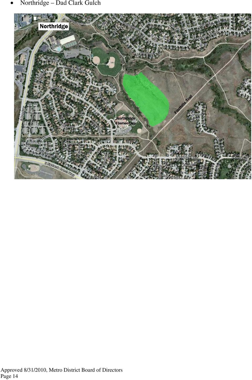
14 Northridge Dad Clark Gulch Page 14
15 b) Areas designated unsuitable for Prairie Dogs in 2008: The following sites have been designated as unsuitable habitat for Prairie Dogs, as identified in Section 4 of this plan. Prairie Dogs in these areas will be completely removed and routinely monitored. Prairie Dogs that relocate back in to these areas will be removed using any method, without public notification, as part of the ongoing and routine management of these areas. Spring Gulch Natural Area from Hyacinth Road to Stone Mountain Drive Management Approach, Spring Gulch, Stone Mountain Drive to Weathersfield Way - Staff will remove prairie dogs and burrows, reclaim/reseed area, and manage weeds. Over the next five years, staff will; re-establish grasses and vegetation, analyze impact of storm flows from upstream development, assess need for channel stabilization improvements, and determine wildlife habitat suitability. Page 15

16 c) Areas Designated as unsuitable in 2010: Vista Trail East of White Pelican Way Marcy Gulch Sand Cherry Way Page 16

17 Spring Gulch Woodrose Court Big Dry Creek at Big Dry Creek Park Page 17

18 References Powell, Kenneth Lee. University of Wisconsin-Stevens Point Prairie Dog Distribution, Habitat Characteristics, and Population Monitoring in Kansas: Implications for Black-Footed Ferret Recovery. Pruett, Alison L. Texas Tech University Black-Tailed Prairie Dog Association with Playa Lakes in the Southern High Plains and a New Approach to Estimating Colony Population sizes. Plumb, Glenn E., Willson, Gary D., Kalin, Kevin., Shinn, Kevin., Rizzo, William M. US Department of Interior, US Geological Survey Black-Tailed Prairie Dog Monitoring Protocol for Seven Prairie Parks. Biggins, Dean E., Miller, Brian J., Hanebury, Louis R., Oakleaf, Bob., Farmer, Adrian H., Crete, Ron., Dood, Arnold. US Department of the Interior, Biological Report Management of Prairie Dog Complexes for the Reintroduction of the Black-Footed Ferret 73-88pp. Beane, Ronald. DATIMBI Environmental Short Term Management Options for Prairie Dogs in the Highlands Ranch Metropolitan Districts. 3pp. Clippinger,N.W Habitat Suitability index models: black tailed prairie dog. U.S. Fish and Wildlife Service Biological Report; 82 (10.156):21p. Cully,J.F Plague in prairie dog ecosystems: Importance for black-footed ferret management. In the prairie ecosystem: Managing for biological diversity. Montana BLM Wildlife Technical Bulletin No.2 p Miller, B.J. 1995b. The History of the Prairie Dog Problem. Paper presented to the Society for Conservation Biology Meeting, June 9, Fort Collins, CO, USA Montana Natural Heritage Program Prairie Dog Colony Observation Form Page 18

19 Prairie Dog Information Sites Colorado Division of Wildlife: Black-Tailed Prairie Dog Relocation Facts This is a question and answer site relating to the Black-tailed Prairie dog. From this site you can access additional information. prariedogpg3.htm Colorado Division of Wildlife: Black-Tailed Prairie Dog Overview PrairieDog.htm Prairie Dog Management Plans: Cities of Lafayette, Boulder, Broomfield and Ft. Collins. Note the differences in contiguous vs. fragmented habitats in each of these agency plans Roe Ecological Services Roe Ecological Services are a private for profit organization. These procedures are for information only and have not been adopted by the Colorado Division of Wildlife. Recommended Prairie dog relocation guidelines: Analysis of the role of the Black-tailed Prairie Dog as a Keystone Species. Habitat Fragmentation Information: State of Wisconsin, Department of Administration, Division of Energy, Environmental Research Program, Final Report, June 2004, Page 19

SANTA BARBARA COUNTY COMPREHENSIVE PLAN LOMPOC AREA
 SANTA BARBARA COUNTY COMPREHENSIVE PLAN LOMPOC AREA A. LAND USE ELEMENT INTERPRETIVE GUIDELINES B. COMMUNITY BENEFITS C. COUNTY ACTION ITEMS Adopted by the Board of Supervisors November 9, 1999 A. Santa
Post-Wildfire Clean-Up and Response in Houston Toad Habitat Best Management Practices
 Post-Wildfire Clean-Up and Response in Houston Toad Habitat Best Management Practices Purpose The purpose of this document is to provide guidance and recommendations for minimizing potential impacts to
Angora Fire Restoration Activities June 24, 2007. Presented by: Judy Clot Forest Health Enhancement Program
 Angora Fire Restoration Activities June 24, 2007 Presented by: Judy Clot Forest Health Enhancement Program California Tahoe Conservancy Independent California State Agency within the Resources Agency Governed
How To Plan A Buffer Zone
 Backyard Buffers Protecting Habitat and Water Quality What is a buffer? A buffer (also called a riparian buffer area or zone) is the strip of natural vegetation along the bank of a stream, lake or other
Wildlife Habitat Conservation and Management Plan
 Wildlife Habitat Conservation and Management Plan For [Applicant Name] [Insert photo of property] Developed in Cooperation with Jane Doe Habitat Conservation Biologist Oregon Department of Fish and Wildlife
1.7.0 Floodplain Modification Criteria
 1.7.0 Floodplain Modification Criteria 1.7.1 Introduction These guidelines set out standards for evaluating and processing proposed modifications of the 100- year floodplain with the following objectives:
STANDARDS FOR RANGELAND HEALTH ASSESSMENT FOR SAGEHEN ALLOTMENT #0208
 STANDARDS FOR RANGELAND HEALTH ASSESSMENT FOR SAGEHEN ALLOTMENT #0208 RANGELAND HEALTH STANDARDS - ASSESSMENT SAGEHEN ALLOTMENT #0208 STANDARD 1 - UPLAND WATERSHED This standard is being met on the allotment.
STATEMENT OF RON HUNTSINGER NATIONAL SCIENCE COORDINATOR BUREAU OF LAND MANAGEMENT U.S
 STATEMENT OF RON HUNTSINGER NATIONAL SCIENCE COORDINATOR BUREAU OF LAND MANAGEMENT U.S. DEPARTMENT OF THE INTERIOR BEFORE THE HOUSE APPROPRIATIONS SUBCOMMITTEE ON INTERIOR, ENVIRONMENT AND RELATED AGENCIES
Using Aerial Photography to Measure Habitat Changes. Method
 Then and Now Using Aerial Photography to Measure Habitat Changes Method Subject Areas: environmental education, science, social studies Conceptual Framework Topic References: HIIIB, HIIIB1, HIIIB2, HIIIB3,
Town of Richmond Hill Beaver Management Policy Summary
 Town of Richmond Hill Beaver Management Policy Summary Above Left: Tree damage from beaver. Above Right: Beaver dam in stream - notice the water level above and below the dam! Below: Beaver swimming. Town
Colorado Natural Heritage Program
 CNHP s mission is to preserve the natural diversity of life by contributing the essential scientific foundation that leads to lasting conservation of Colorado's biological wealth. Colorado Natural Heritage
Wildlife Habitat Conservation and Management Program
 Wildlife Habitat Conservation and Management Program Manual for Counties and Cities Oregon Department of Fish and Wildlife 2015 Table of Contents 1. Introduction Purpose of the habitat program Objective
WEED MANAGEMENT PLAN FOR. (NAME of PROPERTY or MANAGED AREA) (TOWN or COUNTY, STATE) (TIME PERIOD; e.g. 1996-2000)
 (TOWN or COUNTY, STATE) (TIME PERIOD; e.g. 1996-2000)") (WEED MANAGEMENT PLAN OUTLINE FOR PUBLIC LAND MANAGERS) (Note: This outline is a modification of a weed management plan template produced by The Nature Conservancy) WEED MANAGEMENT PLAN FOR (NAME of PROPERTY
(WEED MANAGEMENT PLAN OUTLINE FOR PUBLIC LAND MANAGERS) (Note: This outline is a modification of a weed management plan template produced by The Nature Conservancy) WEED MANAGEMENT PLAN FOR (NAME of PROPERTY
San Francisco Bay Area Wetlands Restoration Program Design Review Group. Project Summary Outline
 San Francisco Bay Area Wetlands Restoration Program Design Review Group Project Summary Outline The project proponent desiring to have a project considered by the Design Review Group (DRG) shall provide
Appendix E: Stewardship Program
 E Appendix E: Stewardship Program This section of the Open Space Plan establishes the basis and provides recommendations for a Stewardship Program for the Wake County Open Space Program. As Wake County
Revising the Nantahala and Pisgah Land Management Plan Preliminary Need to Change the Existing Land Management Plan
 Revising the Nantahala and Pisgah Land Management Plan Preliminary Need to Change the Existing Land Management Plan Throughout the Plan 1. There is a fundamental need for the revised plan to address how
4.2 Buena Vista Creek Watershed
 Buena Vista Creek Watershed 4.2 Buena Vista Creek Watershed Watershed Overview The Buena Vista Creek Watershed is the fourth-largest system within the Carlsbad Hydrologic Unit. The watershed extends approximately
Multiple Species Conservation Program County of San Diego. A Case Study in Environmental Planning & The Economic Value of Open Space
 Multiple Species Conservation Program County of San Diego A Case Study in Environmental Planning & The Economic Value of Open Space Amy M. Fox Land Use Law Case Study Autumn Semester, 1999 Multiple Species
Management Plan Template For Conservation Easements Held by CPW
 Management Plan Template For Conservation Easements Held by CPW The following template provides guidelines for developing a management plan for a property that will have a Conservation Easement held by
Addendum D. Nomination of Moody Wash ACEC
 Addendum D Nomination of Moody Wash ACEC Moody Wash ACEC is hereby nominated by Citizens for Dixie s Future to: BLM St. George Field Office 345 East Riverside Drive St. George, UT 84790 Moody Wash is a
LIVING LANDS Helping Land Trusts Conserve Biodiversity
 LIVING LANDS Helping Land Trusts Conserve Biodiversity Land Trust Biodiversity Survey, Winter 2006 Purpose of Survey To better understand local land trusts current activities and interest in biodiversity
CITY OF UKIAH TREE MANAGEMENT GUIDELINES TREE MANAGEMENT POLICIES FOR THE PROTECTION, OPERATION AND MAINTENANCE OF CITY PROPERTY
 CITY OF UKIAH TREE MANAGEMENT GUIDELINES TREE MANAGEMENT POLICIES FOR THE PROTECTION, OPERATION AND MAINTENANCE OF CITY PROPERTY FINAL DRAFT November 2010 1.0 PURPOSE STATEMENT The purpose of this document
CONSERVING OUR RURAL ENVIRONMENT
 HUME CITY COUNCIL CONSERVING OUR RURAL ENVIRONMENT Grant Guidelines 2015 2016 hume.vic.gov.au CONTENTS 1. GRANT OVERVIEW 1 1.1 Program introduction 1 1.2 Who can apply? 1 1.3 Grant types 1 2. GRANT SELECTION
Chapter 3 SENSITIVE AREAS AND VEGETATED CORRIDORS
 Chapter 3 3.01 General Provisions 3.01.1 Introduction 3.01.2 Application and Interpretation of Chapter 3.01.3 Unbuildable Lots 3.01.4 Other Permits 3.01.5 Prohibited Activities 3.02 Service Provider Letter
Restoring Anadromous Fish Habitat in Big Canyon Creek Watershed. Summary Report 2002
 Restoring Anadromous Fish Habitat in Big Canyon Creek Watershed Summary Report 2002 DOE/BP-00005268-5 November 2002 This Document should be cited as follows: "Restoring Anadromous Fish Habitat in Big Canyon
POLICY ON THE RELOCATION OF WILDLIFE
 State of New Jersey Department of Environmental Protection Mail Code 501-03 Division of Fish and Wildlife PO Box 420 / 501 East State Street Trenton, NJ 08625-0420 POLICY ON THE RELOCATION OF WILDLIFE
SCHEDULE 2 TO THE DEVELOPMENT PLAN OVERLAY Shown on the planning scheme map as DPO2 WAVERLEY GOLF COURSE, LYSTERFIELD VALLEY
 SCHEDULE 2 TO THE DEVELOPMENT PLAN OVERLAY Shown on the planning scheme map as DPO2 WAVERLEY GOLF COURSE, LYSTERFIELD VALLEY 1.0 Conditions and requirements for permits A permit to use and develop the
Appendix C. Municipal Planning and Site Restoration Considerations
 Appendix C Municipal Planning and Site Restoration Considerations 67 68 Appendix C - Municipal Planning and Site Restoration Considerations This appendix contains best practice standards for site planning
Restoring America s Everglades Progress and Next Steps for Restoring a Treasured Landscape and Sustaining a Way of Life
 Restoring America s Everglades Progress and Next Steps for Restoring a Treasured Landscape and Sustaining a Way of Life Credits: Carlton Ward, Jr./ CarltonWard.com There are no other Everglades in the
First Annual Centennial Strategy for. Yucca House National Monument
 First Annual Centennial Strategy for Yucca House National Monument August 2007 Year: 2007 Vision Statement Yucca House National Monument was set aside in 1919 to preserve an unexcavated Ancestral Puebloan
Use: Cooperative farming as a habitat management tool to enhance and restore refuge grasslands
 Compatibility Determination Use: Cooperative farming as a habitat management tool to enhance and restore refuge grasslands District Name: Minnesota Valley Wetland Management District Establishing and Acquisition
File Code: 1950-1 Date: June 24, 2013 Subject: Mulberry River Watershed Improvement and Access Project
 United States Department of Agriculture Forest Service Boston Mountain Ranger District TTY 479-667-1931 1803 N. 18 th Street Ozark, AR 72949 Phone 479-667-2191 FAX 479-667-5807 File Code: 1950-1 Date:
Michigan Wetlands. Department of Environmental Quality
 Department of Environmental Quality Wetlands are a significant component of Michigan s landscape, covering roughly 5.5 million acres, or 15 percent of the land area of the state. This represents about
18 voting members 44 stakeholders 114 email list. Senators: Wyden & Merkley Representative DeFazio
 18 voting members 44 stakeholders 114 email list Senators: Wyden & Merkley Representative DeFazio State Representative Krieger State Senators: Roblan, Johnson, and Kruse Governor Brown s office County
Tree Management Guidelines
 Tree Management Guidelines Overview Tree Management Guidelines The trees that make up Brisbane s urban forest create much of our subtropical landscape character and biodiversity. Almost half of the city
Adopted 9/23/98 CHATTAHOOCHEE CORRIDOR PLAN. The goals of the Chattahoochee Corridor Plan (hereinafter also referred to as the Plan ) are:
 are:") CHATTAHOOCHEE CORRIDOR PLAN Adopted 9/23/98 PART 1: GOALS. POLICY. COVERAGE. A. Goals The goals of the Chattahoochee Corridor Plan (hereinafter also referred to as the Plan ) are: 1. Preservation and protection
CHATTAHOOCHEE CORRIDOR PLAN Adopted 9/23/98 PART 1: GOALS. POLICY. COVERAGE. A. Goals The goals of the Chattahoochee Corridor Plan (hereinafter also referred to as the Plan ) are: 1. Preservation and protection
Nevada Pinyon-Juniper Partnership Proposed Demonstration Area A Brief Introduction. Presented by Jeremy Drew Project Manager Resource Concepts, Inc.
 Nevada Pinyon-Juniper Partnership Proposed Demonstration Area A Brief Introduction Presented by Jeremy Drew Project Manager Resource Concepts, Inc. What I ll Discuss: Purpose of a Demonstration Area Priorities
APPENDIX B: TRAIL DEVELOPMENT AND MANAGEMENT STANDARDS
 APPENDIX B: TRAIL DEVELOPMENT AND MANAGEMENT STANDARDS This section provides guidance on a variety of trail issues for planners and developers of the Ice Age NST across the state. It also provides introductory
Conservation Tax Credit Regulations Chapter 391-1-6 A-1 RULES OF GEORGIA DEPARTMENT OF NATURAL RESOURCES CHAPTER 391-1-6
 Conservation Tax Credit Regulations Chapter 391-1-6 A-1 RULES OF GEORGIA DEPARTMENT OF NATURAL RESOURCES CHAPTER 391-1-6 GEORGIA CONSERVATION TAX CREDIT PROGRAM TABLE OF CONTENTS 391-1-6-.01 Purpose and
CLACKAMAS COUNTY ZONING AND DEVELOPMENT ORDINANCE
 1008 STORM DRAINAGE (3/24/05) 1008.01 PURPOSE To minimize the amount of stormwater runoff resulting from development utilizing nonstructural controls where possible, maintain and improve water quality,
2010 Salida Community Priorities Survey Summary Results
 SURVEY BACKGROUND The 2010 Salida Community Priorities Survey was distributed in September in an effort to obtain feedback about the level of support for various priorities identified in the draft Comprehensive
Clean Water Services. Ecosystems Services Case Study: Tualatin River, Washington
 Viewed broadly, the concept of ecosystem services describes the many resources and services provided by nature. Typically, traditional planning and development practices do not adequately represent the
Photo courtesy of the National Wild Turkey Federation NON-GAME GAME
 FORESTS AND WILDLIFE Wildlife and forest management are not only compatible, but are interrelated. Developing an active forest resource management plan allows you to place a special emphasis on wildlife
UNITED STATES DEPARTMENT OF THE INTERIOR BUREAU OF LAND MANAGEMENT
 Form 1221-2 (June 1969) UNITED STATES DEPARTMENT OF THE INTERIOR BUREAU OF LAND MANAGEMENT MANUAL TRANSMITTAL SHEET Subject: BLM Manual 5716 Protective Measures Release 5-161 Date 7/7/15 1. Explanation
Stream Restoration Post-Implementation Annual Monitoring Report Year 2: 2013 Covering the Period of July 2012 to July 2013
 NCDA&CS - North Carolina Forest Service Stream Restoration Post-Implementation Annual Monitoring Report Year 2: 2013 Covering the Period of July 2012 to July 2013 For the N.C. Division of Water Quality
Monitoring Riparian Areas With a Camera
 Monitoring Riparian Areas With a Camera By Michael DeLasaux 1, Holly George 2, and Philip Mainwaring 3 Riparian areas are next to streams, springs, rivers, ponds and lakes. Physical characteristics that
13. ENVIRONMENTAL PROTECTION/ RESOURCE MANAGEMENT
 13. ENVIRONMENTAL PROTECTION/ RESOURCE MANAGEMENT A. Existing Conditions Ramsey is fortunate to have an ample amount of natural resources and open space areas and a community attitude that is increasingly
March 2008. Prepared by: Irvine Ranch Water District. 15600 Sand Canyon Avenue. Irvine, CA 92618. Contact: Natalie Likens (949) 453-5633
 453-5633") ADDENDUM TO THE MICHELSON WATER RECLAMATION PLANT PHASE 2 & 3 CAPACITY EXPANSION PROJECT FEBRUARY 2006 FINAL ENVIRONMENTAL IMPACT REPORT AND THE SAN JOAQUIN FRESHWATER MARSH ENHANCEMENT PLAN REVISED SEPTEMBER
ADDENDUM TO THE MICHELSON WATER RECLAMATION PLANT PHASE 2 & 3 CAPACITY EXPANSION PROJECT FEBRUARY 2006 FINAL ENVIRONMENTAL IMPACT REPORT AND THE SAN JOAQUIN FRESHWATER MARSH ENHANCEMENT PLAN REVISED SEPTEMBER
THE LEAGUE OF WOMEN VOTERS OF WASHINGTON COUNTY PROGRAM FOR ACTION
 THE LEAGUE OF WOMEN VOTERS OF WASHINGTON COUNTY PROGRAM FOR ACTION I. PUBLIC TRANSPORTATION (1988, 2006) The LWVWC supports coordinated public transportation service in Washington County and Northwest
Road Monitoring on BLM Lands 2005-BLM-503. Las Vegas Field Office 2011
 Road Monitoring on BLM Lands 2005-BLM-503 Las Vegas Field Office 2011 BLM Carolyn Ronning, Habitat Conservation Coordinator Las Vegas Field Office 4701 N. Torrey Pines Drive Las Vegas, NV 89130 702-515-5143
Rhode Island NRCS received approximately $2.4 million in ARRA funds to implement four floodplain easement projects.
 American Recovery and Reinvestment Act (ARRA) Emergency Watershed Protection Program Floodplain Easements Rhode Island Natural Resources Conservation Service Rhode Island NRCS received approximately $2.4
ON THE RELOCATIO Division of
 New Jersey Department off Environmental Protection Division of Fish and Wildlife Mail l Code 501-03 PO Box 4200 / 501 East State St Trenton, NJ 08625-0420 POLICY ON THE RELOCATIO ON OF WILDLIFE As the
AN INITIATIVE TO IMPROVE
 L OW E R C A R M E L R I V E R A N D L AG O O N F L O O D P L A I N R E S TO R AT I O N A N D E N H A N C E M E N T P R O J E C T AN INITIATIVE TO IMPROVE FLOOD PROTECTION RESTORE AND PROTECT RIPARIAN
Series 2016A-2 (Green Bonds) Final Proceeds Allocation April 2016
 Final Proceeds Allocation April 2016") Series 2016A-2 (Green Bonds) Final Proceeds Allocation April 2016 James L. McIntire Washington State Treasurer Summary The State of Washington offered green bonds to investors in September 2015, with approximately
Series 2016A-2 (Green Bonds) Final Proceeds Allocation April 2016 James L. McIntire Washington State Treasurer Summary The State of Washington offered green bonds to investors in September 2015, with approximately
King Fire Restoration Project, Eldorado National Forest, Placer and El Dorado Counties, Notice of intent to prepare an environmental impact statement.
 This document is scheduled to be published in the Federal Register on 12/24/2014 and available online at http://federalregister.gov/a/2014-30158, and on FDsys.gov [3410-11- P] DEPARTMENT OF AGRICULTURE
Ecosystem Services in the Greater Houston Region. A case study analysis and recommendations for policy initiatives
 Ecosystem Services in the Greater Houston Region A case study analysis and recommendations for policy initiatives Ecosystem Services Ecosystems provide services through their natural processes that we
What Is Rehabilitation?
 Location of Aggregate Operations Ready Mix Plant Locations Aggregate Locations Cement Terminal Locations What Is Rehabilitation? Rehabilitation is the treatment of land from which aggregate has been excavated
Flood Plain Reclamation to Enhance Resiliency Conserving Land in Urban New Jersey
 Flood Plain Reclamation to Enhance Resiliency Conserving Land in Urban New Jersey Rutgers Cooperative Extension Water Resources Program Christopher C. Obropta, Ph.D., P.E. Email: obropta@envsci.rutgers.edu
Arapaho & Roosevelt National Forests 2013 Flood: Long-term Recovery in a Changed Landscape
 Arapaho & Roosevelt National Forests 2013 Flood: Long-term Recovery in a Changed Landscape Spring 2014 The flood of September 2013 changed the landscape of the Boulder and Canyon Lakes Ranger Districts.
3.4 DRAINAGE PLAN. 3.4.1 Characteristics of Existing Drainages. 3.4.2 Master Drainage System. Section 3: Development Plan BUTTERFIELD SPECIFIC PLAN
 3.4 DRAINAGE PLAN This section describes the existing onsite drainage characteristics and improvements proposed within this Specific Plan. Following this description, drainage plan development standards
Lesson Overview. Biodiversity. Lesson Overview. 6.3 Biodiversity
 Lesson Overview 6.3 6.3 Objectives Define biodiversity and explain its value. Identify current threats to biodiversity. Describe how biodiversity can be preserved. THINK ABOUT IT From multicolored coral
Water Quality and Water Usage Surveys
 Appendix 1 Water Quality and Water Usage Surveys This appendix contains copies of the Water Quality Survey and the Lake Usage Survey that we used to complete the watershedbased community assessments. We
Council Policy for New Telecommunication Facilities
 Council Policy for New Telecommunication Facilities 1. Purpose To establish policies and procedures for the installation of new telecommunication antennas, towers and related structures which emphasize
Wildfire & Flash Flood Recovery NACo Justice & Public Safety Symposium January 2014
 Wildfire & Flash Flood Recovery NACo Justice & Public Safety Symposium January 2014 Fall 2013 Jim Reid Executive Director Public Service El Paso County, Colorado Recovery Specific to Incident Recovery
TABLE OF CONTENTS. INTRODUCTION...1 Purpose of a Comprehensive Plan...1 McKenzie County Comprehensive Plan...1 Definitions...2 Goal...2 Vision...
 MCKENZIE COUNTY COMPREHENSIVE PLAN TABLE OF CONTENTS INTRODUCTION...1 Purpose of a Comprehensive Plan...1 McKenzie County Comprehensive Plan...1 Definitions...2 Goal....2 Vision...3 ECONOMIC DEVELOPMENT...4
Roaring Fork Valley Restoration Strategy
 Roaring Fork Valley Restoration Strategy Future Forest Roundtable Future Forest Roundtable Roaring Fork Valley Restoration Strategy T he restoration strategy in the Roaring Fork Valley of the White River
Extinction; Lecture-8
 I. introduction Definition Current extinction Genetic drift Extinction; Lecture-8 II. 3 types of extinction 1. background 2. mass 3. stochastic III. 5 periods of mass IV. human caused 1. on land and in
Controlling Invasive Plants and Animals in our Community
 Controlling Invasive Plants and Animals in our Community PROVIDED BY THE WILDLIFE COMMITTEE What makes a plant or animal invasive? When a plant or animal from another region of the world (usually Europe
THE SECRETARY OF THE INTERIOR WASHINGTON
 THE SECRETARY OF THE INTERIOR WASHINGTON ORDER NO. 3336 Subject: Rangeland Fire Prevention, Management and Restoration Sec. 1 Purpose. This Order sets forth enhanced policies and strategies for preventing
Summary of Pre- and Post-Project Vegetation Survey Results
 3921 East Bayshore Road Palo Alto CA 94303-4326 tel 650.962.9876 fax 650.962.8234 www.acterra.org info@acterra.org Introduction Summary of Pre- and Post-Project Vegetation Survey Results Acterra Stewardship
Pest Control Methods and Tips
 Waterway Technote Pest animals Contents Benefits of animal pest control 1 Common pest animal species found in riparian areas and control methods 2 Protecting plants from animal pests 3 Regional pest specific
Recommended Land Use Guidelines for Protection of Selected Wildlife Species and Habitat within Grassland and Parkland Natural Regions of Alberta
 Fish and Wildlife Division Sustainable Resource Development Recommended Land Use Guidelines for Protection of Selected Wildlife Species and Habitat within Grassland and Parkland Natural Regions of Alberta
Passive Restoration 101: Framework and Techniques Overview. Amy Chadwick, Great West Engineering August 26, 2015 Butte, America
 Passive Restoration 101: Framework and Techniques Overview Amy Chadwick, Great West Engineering August 26, 2015 Butte, America What Defines Passive Restoration? Process-based, nature-driven Minimal equipment
Madagascar: Makira REDD+
 project focus Madagascar: Makira REDD+ Madagascar is considered to be one of the top five biodiversity hotspots in the world due to more than 75% of all animal and plant species being endemic while less
Population Ecology. Life History Traits as Evolutionary Adaptations
 Population Ecology An Overview of Population Ecology Population ecology is the study of factors that affect population: Density Growth A population is a group of individuals of a single species that occupy
Prattsville Berm Removal Project. 1.0 Project Location
 Prattsville Berm Removal Project 1.0 Project Location The project site is located between the New York State Route 23 Bridge over the Schoharie Creek and the Schoharie Reservoir. The restoration plan encompassed
INNOVATIONS IN STREAM RESTORATION AND FLOOD CONTROL DESIGN MEETING FLOOD CAPACITY AND ENVIRONMENTAL GOALS ON SAN LUIS OBISPO CREEK 1
 INNOVATIONS IN STREAM RESTORATION AND FLOOD CONTROL DESIGN MEETING FLOOD CAPACITY AND ENVIRONMENTAL GOALS ON SAN LUIS OBISPO CREEK 1 Wayne Peterson 2 Abstract: Can a natural flowing creek be increased
L A N D S C A P E P A T T E R N S
 A PATTERN BOOK FOR NEIGHBORLY HOUSES LANDSCAPE PATTERNS E Landscape Patterns Throughout the United States there is an incredible range of climatic zones, microclimates, plant species, and landscape traditions.
DOÑA ANA COUNTY DESIGN STORM CRITERIA GUIDELINES FOR COMMERCIAL AND RESIDENTIAL SITES. Run-off Analysis Methods
 DOÑA ANA COUNTY DESIGN STORM CRITERIA GUIDELINES FOR COMMERCIAL AND RESIDENTIAL SITES Run-off Analysis Methods This document sets forth the minimum design, technical criteria and specifications for the
Lower Crooked Creek Watershed Conservation Plan EXECUTIVE SUMMARY
 EXECUTIVE SUMMARY Project Background Located in southwestern Pennsylvania, Crooked Creek is a major tributary of the Allegheny River, entering near Ford City in Armstrong County. It is rich in natural
5.2 Condition of our Biodiversity
 Biodiversity is the variety of all life forms - the different plants, animals and micro-organisms, the genes they contain and the ecosystems in which they live. Biodiversity underpins the ecological processes
National Green Jobs Corps 2010
 National Green Jobs Corps 2010 Lower Obi Obi Creek Land & Water Restoration Project Final Report A project to enhance habitat, improve water quality, enhance vegetation linkages, reduce invasive weed species,
Timberland Property Tax in Texas. Yanshu Li Texas Forest Service
 Timberland Property Tax in Texas Yanshu Li Texas Forest Service 1 Outline Timberland property tax State tax incentives for timberland Wildlife management valuation on timberland Landowners rights and remedies
CHECKLIST ENVIRONMENTAL ASSESSMENT I. TYPE AND PURPOSE OF ACTION II. PROJECT DEVELOPMENT
 CHECKLIST ENVIRONMENTAL ASSESSMENT Project Name: K4 Land and Grain Co-Expiring CRP to Agricultural Land Classification Proposed Implementation Date: Spring 2016 Proponent: K4 Land and Grain Co., Lothair,
Thank you to all of our 2015 sponsors: Media Partner
 Thank you to all of our 2015 sponsors: Media Partner Channel Naturalization: Planning and Implementation in Peel Region TRIECA March 25 & 26, 2015 Peel Region Channel Remediation Strategy An Urban Context
COMPREHENSIVE PLAN SECTION B, ELEMENT 4 WATER RESOURCES. April 20, 2010 EXHIBIT 1
 COMPREHENSIVE PLAN SECTION B, ELEMENT 4 WATER RESOURCES April 20, 2010 EXHIBIT 1 ELEMENT 4 WATER RESOURCES TABLE OF CONTENTS 4.1 INTRODUCTION 4.2 GOALS AND POLICIES 4.2.A General Goals and Policies 1 4.2.B
COORDINATED RESOURCE MANAGEMENT PROGRAM LARRY BENTLEY NATURAL RESOURCE AND POLICY SECTION CONSULTANT WYOMING DEPARTMENT OF AGRICULTURE
 WYOMING DEPARTMENT OF AGRICULTURE COORDINATED RESOURCE MANAGEMENT PROGRAM LARRY BENTLEY NATURAL RESOURCE AND POLICY SECTION CONSULTANT WYOMING DEPARTMENT OF AGRICULTURE BRIEF HISTORY OF THE CRMP IN WY0MING
Determination of NEPA Adequacy (DNA)
") DEPARTMENT OF THE INTERIOR BUREAU OF LAND MANAGEMENT MEDFORD DISTRICT OFFICE GRANTS PASS RESOURCE AREA 2164 NE SPALDING AVENUE GRANTS PASS, OR 97526 Determination of NEPA Adequacy (DNA) Office: Grants
DEPARTMENT OF THE INTERIOR BUREAU OF LAND MANAGEMENT MEDFORD DISTRICT OFFICE GRANTS PASS RESOURCE AREA 2164 NE SPALDING AVENUE GRANTS PASS, OR 97526 Determination of NEPA Adequacy (DNA) Office: Grants
Land Disturbance, Erosion Control and Stormwater Management Checklist. Walworth County Land Conservation Department
 Land Disturbance, Erosion Control and Stormwater Management Checklist Walworth County Land Conservation Department The following checklist is designed to assist the applicant in complying with the Walworth
understanding Sustainable Landscaping & Tree Preservation Standards
 understanding Sustainable Landscaping & Tree Preservation Standards Purpose To promote landscaping around development that is compatible with the existing environment, and which reduces greenhouse gas
Dawn Reis Ecological Studies. www.ecologicalstudies.com
 Dawn Reis Ecological Studies www.ecologicalstudies.com Laguna Salada Sharp Park s Federal & State Protected San Francisco Garter Snake (Thamnophis sirtalis tetrataenia) and California Red-legged Frog (Rana
ELEMENT 4 - FUTURE LAND USE ELEMENT
 ELEMENT 4 - FUTURE LAND USE ELEMENT Goal 1 To create a long-range development pattern which directs growth into developable areas and away from environmentally sensitive areas, in a manner that is compatible
PRIVATE TREATMENT CONTROL BMP OPERATION AND MAINTENANCE VERIFICATION FORM BIORETENTION FACILITIES, VEGETATED SWALES & HIGHER RATE BIOFILTERS
 BIORETENTION FACILITIES, VEGETATED SWALES & HIGHER RATE BIOFILTERS Check here for Address or phone number change the fiscal year (July 1 June 30), and date(s) maintenance was performed. Under Inspection,
Chapter Four Resource Management Plan
 Chapter Four Resource Management Plan 4.1 Overview of Resource Management Plan Sensitive resources identified within the Plan area include biological, agricultural, and cultural resources. This section
Toward a Resilient Denver: Preparing for Climate Change. Celia VanDerLoop Denver Environmental Health 720-865-5458
 Toward a Resilient Denver: Preparing for Climate Change Celia VanDerLoop Denver Environmental Health 720-865-5458 GETTING STARTED Western Adaptation Alliance Semi-Arid Cities Facing similar issues Shared
Chapter 3 Planning Issues, Opportunities, and Constraints
 Chapter 3 Planning Issues, Opportunities, and Constraints Introduction This chapter describes the key factors planning issues, opportunities, and constraints that influenced development of this RMP/EA.
Backyard Buffers that Work for People and Nature by Restoring Ecological Function
 Backyard Buffers that Work for People and Nature by Restoring Ecological Function What is a Wetland Buffer? A wetland buffer is a simple land management practice that is employed by municipalities to protect
Woodlands Management Plan. (Draft June 2011) A. Definition of Woodlands Areas vs. Landscaped Areas of Parkfairfax
 A. Definition of Woodlands Areas vs. Landscaped Areas of Parkfairfax") Woodlands Management Plan (Draft June 2011) I. Background A. Definition of Woodlands Areas vs. Landscaped Areas of Parkfairfax The woodlands are defined as those wooded areas of Parkfairfax which are left
Woodlands Management Plan (Draft June 2011) I. Background A. Definition of Woodlands Areas vs. Landscaped Areas of Parkfairfax The woodlands are defined as those wooded areas of Parkfairfax which are left
Laws of Minnesota 2009 Final Report
 Lessard-Sams Outdoor Heritage Council Laws of Minnesota 2009 Final Report Dat e: August 20, 2013 Program or Project T it le: Habitat Protection, Phase 1 Funds Recommended: $1,000,000 Manager's Name: T
APPENDIX F RIGHTS-OF-WAY PRESERVATION GUIDELINES
 Los Angeles County Metropolitan Transportation Authority (Metro) 2009 Transportation Improvement Program Call for Projects APPENDIX F RIGHTS-OF-WAY PRESERVATION GUIDELINES Los Angeles County Metropolitan