Site Plan Modification/Exterior Alterations
|
|
|
- Suzanna Henry
- 3 years ago
- Views:
Transcription
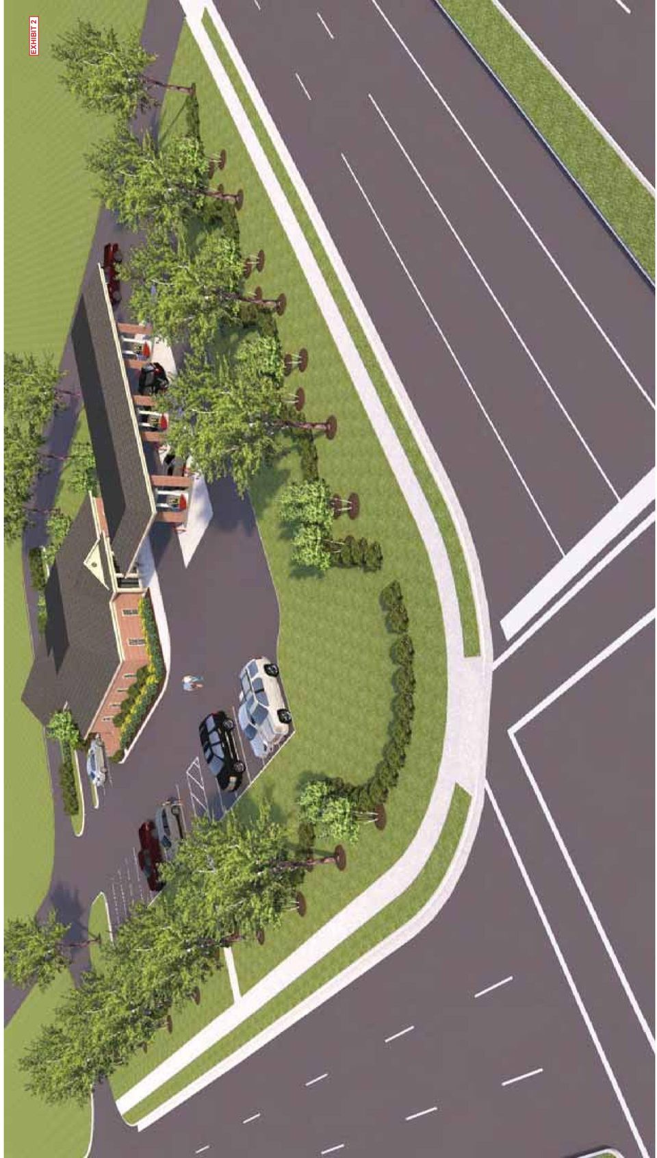
1 Agenda Number: PC PC MEETING DATE: September 4, 2014 REPORT TO THE PLANNING COMMISSION SUBJECT: Almadale Farms PD, Ph Shell Gas Station - Request approval of a Conditional Use Permit (CUP) for conversion of an existing 2,792 square foot building on 1.24 acres from a bank to a 3,675 square foot gas station and convenience store located at 2015 S. Houston Levee Road. INTRODUCTION: Ms. Brenda Solomito with Solomito Land Planning representing property owner David Halle with Houston Levee Commercial and Developer Rooziman Shah with New Development LLC, is requesting a recommendation from the Planning Commission (PC) for a Conditional Use Permit to allow a convenience store with fuel pumps at the northwest corner of Houston Levee Road and Wolf River Boulevard on 1.24 acres. The property, is zoned R-1 with a PD Overlay (Almadale Farms) which permits SCC: Shopping Center Commercial uses on the subject property. EXHIBITS: 1.Applicant s cover letter addressing CUP provisions (7/15/14). 2.Site Plan Modification/Exterior Alterations Exhibits & Renderings (8/21/14) 3.Trip Generation Analysis (7/15/14) 4.Site & Context Photos 5.Staff Comments (08/29/14) 6.Herbie Krisle (08/18/14) The property is surrounded by vacant parcels to the north and west which also allow SCC uses which provide separation between the site and The Laurels Subdivision (further west) and the Page Robbins Adult Day Care Center (further north). A Walgreens Pharmacy is located to the east of the subject property across Houston Levee Road and a First Tennessee Bank and the Almadale Crossing Shopping Center is located south of the subject property across Wolf River Boulevard. All surrounding properties mentioned, except The Laurels, are part of the Almadale Farms Planned Development. ISSUES: There are two issues associated with the application: 1. Is existing road infrastructure adequate for this use? A Trip Generation Analysis (Exhibit 3) was provided and the Planning Commission must waive the requirement for a Level I Traffic Analysis (see Condition 4) which is typically required for the trip generation indicated on the applicants analysis. The Town Engineer has indicated that a Level II Traffic Analysis is not needed since both Wolf River Boulevard and Houston Levee Road have been improved to match the Major Road Plan. 2. Will the site and structures be designed to be compatible with area? The subject property, formerly a Trust One Bank branch location, has been vacant for the past 6 months. The applicant filed a separate site plan modification/exterior alteration request (see Exhibit 2) that is being reviewed administratively. Comments have been issued (Exhibit 5) by staff requesting revisions and further comments are possible (Condition 5). Staff has been working with the applicant to ensure that the design is compatible with surrounding development Exhibits 2 & 4 demonstrate the applicant s intent to design a compatible facility. An administrative development agreement likely given the lack of public improvements. DISCUSSION AND DETAILED ANALYSIS: The pending site plan modifications (Exhibit 2) includes a convenience store, retail, and a detached canopy providing shelter for up to six refueling vehicles at any given time. The retail building will be approximately 3,675 square feet in size and will orient towards Houston Levee Road and Wolf River Boulevard. The canopy will be located in front of the convenience store and will orient towards Houston Levee Road. In addition to the preliminary site layout, the applicant has provided, in Exhibit 2, an existing conditions/survey plan, demolition plan, site layout plan, grading & drainage plan, erosion control 8/29/ :15:10 AM Page 1 of 6

2 plan, combined utility plan, a landscaping and irrigation plan, lighting plan, architectural plan, and a canopy plan. Auto rental sales shall not be permitted at the site (Condition 3). An (Exhibit 6) from Herbie Krisle, representing the Page Robbins Adult Day Care Center, indicates his general support for the gas station convenience store but mentions that he would like some additional plantings around the dumpster and loading areas. A summary of major features follows: 6-Prong CUP Test: Staff has been working with the applicant on a site plan modification/exterior alteration application to ensure that the design is compatible with surrounding development (see Exhibit 3 for Photos) and minimize any adverse impacts to adjacent property, a requirement for the 6-Prong CUP Test. See the applicant s cover letter (Exhibit 1) for responses to the Grounds for Issuance of a Conditional Use Permit. The Planning Commissions review of the Condition Use Permit Test is summarized below. A convenience store with retail fuel sales in GC General Commercial or SCC Shopping Center Commercial zoning district requires a conditional use permit from the Board of Mayor and Aldermen. A conditional use is a use that would not be appropriate generally or without restriction throughout the zoning district but which would promote the public health, safety, welfare, morals, order, comfort, convenience, appearance, prosperity or general welfare. Such uses may be permitted in such zoning district as conditional uses, if specific provisions are met. Conditional uses typically meet the purpose and intent of the zoning district but require the approval of the appropriate review body to ensure that any adverse impacts on adjacent uses, structures, or public services and facilities are mitigated, and any special requirements unique to that use are addressed. The Planning Commission may: recommend approval or denial of a request based on the standards (see below); recommend additional conditions of approval if findings are citied beyond such generalities as in the interest of public health, safety and general welfare; and provide flexibility from the strict application of the zoning ordinance, as circumstances may arise where the standards of the zoning district are inconsistent with the requirement for compatibility with surrounding property. A condition may be less restrictive than the standards of the zoning district if the Commission specifically cites the reasoning for the condition based on compatibility with the surrounding property. All approved plans, conditions, restrictions, and requirements made part of the approval run with the land. 6-Prong Test for a conditional use permit (General Standards): A conditional use permit shall be granted, provided the Mayor and Aldermen, with a recommendation from the Planning Commission, finds that the proposed use complies with the following. (See staff analysis in right column.) Conditional Use Test Test 1: Does the use conform to all applicable provisions of the zoning district in which it is to be located, unless modified as part of the conditional use application per of Collierville s Town Code of Ordinances? Test 2: Does the use conform to the Footnotes of and the Specific Provisions for Conditional Uses as set forth in Test 3: Is the use consistent with the overall character of existing development in the immediate vicinity of the subject property, and will the use not materially adversely affect other property in the area in which it is located? Staff Analysis of the Application The Site Layout (Exhibit 2) along with the changes required by the Conditions will bring the site into compliance with the Zoning Ordinance and Design Guidelines. Staff has noted additional issues related to the Design Guidelines in the report and has included recommended Conditions of Approval that may address those issues as well. There are no special footnotes applicable to convenience store or retail fuel pump uses in SCC per or The proposed use is consistent with the existing and potential uses in the vicinity of the subject property, which includes a variety of retail and commercial uses (described more fully in this report). The building and canopy are designed to match area and significant landscaping provided to prevent adverse impacts. Conditions have been added to ensure compatibility of character and minimize adverse impacts to adjacent property. 8/29/ :15:10 AM Page 2 of 6

3 Conditional Use Test Test 4: Is the use generally consistent with the policies of the Collierville Land Use Plan for the parcel or surrounding neighborhood, including any applicable Small Area Plans? Test 5: Will the use adversely affect a known archaeological, environmental, historical or cultural resource? Test 6: Are there adequate public facilities and services intended to serve the subject property, including but not limited to roadways, transit service, parks and recreational facilities, police and fire protection, hospitals and medical services, schools, storm water drainage systems, water supplies, and wastewater and refuse disposal? Staff Analysis of the Application The Town s Land Use Plan indicates that the subject property should develop as Suburban Commercial. There are no known archaeological, environmental, historical or cultural resources on the site or in the immediate vicinity. Adequate public and private facilities currently exist to serve a convenience store with fuel pumps, or will exist once the PC Conditions have been added to ensure adequate facilities. Specifically, Houston Levee Road and Wolf River Boulevard have already been improved per the Major Road Plan and are adequately designed to handle traffic from a convenience store. Bulk Regulations: Table 1 indicates a Site Plan Data Summary of the bulk requirements which have been met assuming a parking ratio of one (1) parking space per 200 square feet of building floor area. Buffers, Access & Circulation: There is access into the property from Wolf River Boulevard and Houston Levee Road and between the property and adjacent undeveloped properties via a shared access drive which wraps the site to the north and west. Appendix II of the Design Guidelines requires 40 front yard buffers along arterial streets. A 40 buffer will remain along both frontages with parking areas altered for the fuel pumps. The existing site does not contain a detention basin and due to no major changes in runoff and the site s close proximity to the Wolf River it has been determined that no addition detention is necessary with this application. TABLE 1 SITE PLAN DATA SUMMARY Convenience Store Fuel Center Almadale Farms PD, Phase 15 Zoning District R-1 with PD allowing SCC: Shopping Center Commercial Site Area 1.24 ac. Gross Building Floor Area Floor Area Ratio (FAR) Maximum Allowed in SCC Use Proposed FAR Parking Requirements Minimum Required (1/200) Proposed Parking Green Space (%) Minimum Required Proposed Green Space Building Height Maximum allowed Proposed Building Height (Max.) Setbacks Required Front: 50 (Wolf River Blvd.) 50 (Houston Levee Road) Side: 15 adjoining non-residential Rear: 30 3,675 sq. ft. Survey (Exhibit 2): The Survey indicates existing topography, buildings, landscape areas, sidewalks, easements, and utilities for the subject property. Preliminary Site Layout (Exhibit 2): As noted above, the applicant has chosen to orient the convenience store fuel pump canopy along Houston Levee Road frontage. The internal drive isles, proposed building, and canopy location meet the requirements of the Fire Marshal assuming canopy clearance is adequate but not exceeding 15 as required by the Zoning Ordinance (Section (7)(c)). Parking for the site is located along the north and south side of the convenience store. North of the building the parking and dumpster is served by a drive lane only adequate for one-way traffic which will continue to circulate north to south as it did for the previous bank use. The Zoning Ordinance allows for queuing spaces provided at the gas island(s) to be counted towards the minimum parking requirement. Six (6) of the site s 25 parking spaces are provided at the fuel pumps. Outdoor storage for propane tanks are not indicated on the plans. A note will be added to the Final Site Plan indicating no outdoor display area except as shown on this plan (including 6 at fuel pumps) 28% (P.D.) 42% 70 No change (1 story building) Setbacks Proposed Front: 97.9 (Wolf River) 123 (Houston Levee) Side (west): +/ Rear (north): +/- 77 8/29/ :15:10 AM Page 3 of 6

4 Sidewalks connecting to both Houston Levee Road and Wolf River Boulevard will be installed by the applicant. The applicant should also add a sidewalk connecting Houston Levee Road to the buildings primary façade The subject property is located at a major intersection (of two major roads: Houston Levee Road and Wolf River Boulevard) that serves as a gateway into the Town of Collierville. The Design Guidelines (Ch.III.A.3) recommend using building placement and special elements (walls, monuments, landscaping, etc.) to define the character of an area at major intersections. The DRC, at the August 14 th work session, was asked for their thoughts on a feature at this intersection. The DRC did not feel it was necessary as the bank was constructed prior to this requirement and none of the other three corners of the intersection contain such a feature. Preliminary Grading Plan (Exhibit 2): The applicant proposes to only minor site plan modifications effecting drainage. The primary change effecting grading and drainage is in the vicinity of the former bank drive-thru in which the canopy is being enclosed and becoming part of the building. Parking in the vicinity of the drive through along with a dumpster enclosure north of the building is proposed and will slightly alter the sites grading. Existing and proposed drainage is captured and exits the site near the southeast corner tying to a drain line in Wolf River Boulevard. Preliminary Utility Plan (Exhibit 2): Utilities, including water and sewer, exist to serve the site. A 2 water line serves the site from Houston Levee Road while the sanitary sewer exits the site to the east near the southwest corner. A 2 gas line originating from Houston Levee Road also serves the site. Existing Landscape Plan (Exhibit 2): The Existing Landscape Plan indicates the plantings to be removed as well as those which are to remain. A total of twelve (12) trees from the original approved landscape plan will be removed including the following species: Silver Maples, Crape Myrtles, and Cherry Trees. Since trees to be removed were approved on the original landscape plans all twelve (12) will need to be replaced. Currently only one (1) tree is indicated as a mitigation tree. A total of twelve (12) mitigation trees are required to replace the twelve (12) removed. Consider planting several of the mitigation trees in the island on the west property line in order to help hide the west wall from the former bank canopy which contains to windows. Landscape Plans (Exhibit 2): As mentioned above, the 40-foot buffer along the Houston Levee Road and Wolf River Boulevard frontages will remain. The site includes street trees, evergreen plantings to screen the parking and trash enclosure, and foundation plantings. Additional plantings should be planted in the island west of the building to help conceal the west elevation of the now enclosed addition as there are no windows or room for foundation plantings between the one-way drive and the building. The site exceeds the open space recommendations of the Design Guidelines. An was received from an adjacent property owner, Herbie Krisle with Page Robbins (see Exhibit 6), who would like to see additional screening of the service areas on the north side of the convenience store. The applicant has added some additional plantings on the north side of the building to address the adjacent property owners concerns. Lighting Plans (Exhibit 2): The set of plans does not include light fixture cut sheets which were submitted as 8 ½ x 11 copies separate from the plans. The applicant will be required to place the cut sheets onto the plan set as part of the site plan approval. the location of the external light fixtures nor type of fixture. All light fixtures will be required to meet the requirements of the Lighting Ordinance. Elevations (Exhibit 2): The former bank canopy is being enclosed and incorporated into the building. The façade to be enclosed along Wolf River Boulevard includes windows of a similar spacing to the existing façade but does not contain windows on the west facing elevation. There are existing shrubs which will remain along the west property line to help hide the window-less wall. If mitigation trees are planted in this island then the wall will be further screened at least while the trees hold their leaves. The primary building materials for the 8/29/ :15:10 AM Page 4 of 6
 recommend using building placement and special elements (walls, monuments, landscaping, etc.) to define the character of an area at major intersections.")
5 existing building is brick (façade, canopy columns, and screen wall), EIFS (gable, cornice) and architectural shingles. The drive-thru to be enclosed along with the fuel canopy will be of similar materials with windows and an entry door facing the Wolf River Boulevard frontage. The west face of the drive-thru to be enclosed does not contain walls and either faux windows or additional landscape is needed to help soften that façade. The fuel canopy has a base and additional banding has been requested on the columns to provide more interest. The elevations provide some callout but are not adequate as more labeling, dimensions, and colors/finishes are needed. The applicant is proposing a freestanding fuel canopy featuring brick support columns, an EIFS cornice (fascia), and a shingled hip roof that is in scale with surrounding development. The color of the EIFS cornice is not indicated on the elevations but should be a natural color (not white). The canopy columns shall contain a base and banding to provide interest. The Zoning Ordinance (Section (7)(e)) require that all lighting should be full cut-off and recessed into the canopy to prevent glare and light trespass. To respect the existing architectural character, architectural dimensional shingles are proposed for the canopy. Signage is not included in this approval. A sign permit application shall be submitted to the Planning Division prior to the erection of any signage. NEXT STEPS: Board of Mayor and Aldermen (BMA) Approval of the Conditional Use Permit: Once the PC has made a recommendation, the BMA, on September 22, 2014, will consider the Conditional Use Permit. Site Plan Modification/Exterior Alteration Development Agreement: Assuming the BMA approves the Conditional Use Permit, the Site Plan Modification shall be revised to address the CUP Conditions and any Departmental Review Team (DRT) comments which will be followed by a Development Agreement. An Administrative Development Agreement is likely. PC EXAMPLE MOTION AND CONDITIONS OF APPROVAL: To recommend that the BMA approve the request (Exhibit 1) for a Conditional Use Permit for conversion of an existing 2,792 square foot building on 1.24 acres from a bank to a 3,675 square foot gas station and convenience store located at 2015 S. Houston Levee Road, subject to the following conditions: 1. This development is subject to all applicable standard conditions of approval as adopted by the Board of Mayor and Aldermen, Resolution The Conditional Use Permit for a convenience store with fuel pumps shall become null and void if the applicant does not enter into a Development Agreement for Site Plan Modification/Exterior Alterations by 09/08/ No Automobile rental uses shall be permitted at the subject property. 4. The Planning Commission waives the requirement for a Level I Traffic Analysis and instead permits the Trip Generation Analysis (Exhibit 3) as an acceptable substitution. 5. The Site Plan Modification/Exterior Alteration request shall be modified to reflect comments in Exhibit 5 prior to a Development Agreement being executed. These comments are based on the versions of the plan received July 15, Further comments may be issued upon review of subsequent revisions and prior to executing a Development Agreement. 8/29/ :15:10 AM Page 5 of 6

6 CONTACTS: Property Owner Applicant Applicant s Representative Project Planners Contact: David Halle Rooziman Shah Brenda P. Solomito Scott Henninger (primary) Jaime Groce Organization: Houston Levee New Development, LLC Solomito Land Planning Town of Collierville Address: Commercial 3284 Shea Road Collierville, Tennessee Poplar Avenue Memphis, Tennessee Kirby Parkway Memphis, TN Poplar View Parkway Collierville, TN Phone: (901) (901) (901) Fax: lowgrove@bellsouth.n roozimanshah@yahoo.co brendasolomito@bellsou et m th.net shenninger@ci.collierville. tn.us 9/2/2014 8:59:08 AM Page 6 of 6
 853-0763 (901) 237-3553 (901) 755-7495 457-2360 Fax: 457-2354 Email: lowgrove@bellsouth.n roozimanshah@yahoo.co brendasolomito@bellsou et m th.net shenninger@ci.")
7 EXHIBIT 1

8 EXHIBIT 1

9

10 EXHIBIT 2
11 EXHIBIT 2

12 EXHIBIT 2

13 EXHIBIT 2

14 EXHIBIT 2

15 EXHIBIT 2

16 EXHIBIT 2

17 EXHIBIT 2

18 EXHIBIT 2

19 EXHIBIT 2

20 EXHIBIT 2

21 EXHIBIT 2
22 EXHIBIT 2
23 EXHIBIT 2
24 EXHIBIT 2
25 EXHIBIT 2
26 EXHIBIT 2
27 EXHIBIT 2
28 EXHIBIT 2
29 EXHIBIT 2
30 EXHIBIT 2
31 EXHIBIT 2
32 EXHIBIT 2
33 EXHIBIT 2
34 EXHIBIT 2
35 EXHIBIT 3
36 EXHIBIT 4
37 EXHIBIT 4
38 EXHIBIT 4
39 TOWN OF COLLIERVILLE Development Department EXHIBIT 5 Jason Gambone Dale Perryman, P.E Tim Pendleton Jaime Groce, AICP Director Town Engineer Building Official Town Planner. 500 Poplar View Parkway Collierville, TN (901) FAX (901) To: Rooziman Shah David Halle New Development, LLC Houston Levee Commercial 4640 Poplar Avenue 3284 Shea Road Memphis, Tennessee Collierville, Tennessee Via: roozimanshah@yahoo.com Via: lowgrove@bellsouth.net Brenda P. Solomito Barbara Hildebrandt Solomito Land Planning Houston Levee Commercial 2067 Kirby Parkway 3284 Shea Road Memphis, TN Collierville, Tennessee Via: brendasolomito@bellsouth.net Via: higrove@bellsouth.net Cc: Jaime Groce, AICP Scott Henninger, AICP Town Planner Project Planner From: Jay O. Northrup, AICP Development Technician Date: August 29, 2014 (including previous staff comments issued August 14, 2014) Application: DD , Shell Gas Station, Almadale Farms PD, Ph. 15- Request approval of a Conditional Use Permit (CUP) for conversion of an existing 2,792 square foot building on 1.24 acres from a bank to a gas station and convenience store located at 2015 S. Houston Levee Road. 1. Canopy clearance height shall not exceed 15 (Zoning Ordinance (7)(c)). 2. Add note to Final Site Plan that says no outdoor display area except as shown on this plan. 3. Provide a total of 12 mitigation trees to replace the 12 trees to be removed that were on the approved landscape plan for the former bank. 4. Indicate all ground and attached appurtenances (i.e. backflow preventers, utilities, meters, mechanical equipment, etc.) which shall be screened with evergreen landscaping and/or a masonry wall matching the principle façade and all rooftop appurtenances shall be screened by the parapet. Paint wall mounted appurtenances to match the color of the surrounding building material (Site Plan Checklist). 5. The applicant shall place the 8 ½ x 11 cut sheets for all exterior light fixtures requested for this site on the Final Lighting Plan Sheets (Site Plan Checklist). All light fixtures will be required to meet the requirements of the Lighting Ordinance. 6. Evergreen landscaping is required to screen the light fixtures for any proposed ground signs and all lighting shall be full cut-off and recessed into the canopy to prevent glare and light trespass (Lighting Ordinance). 7. For the Final Site Plan, indicate Americans with Disabilities Act (ADA) compliant ramps at driveway connections and the parking lot access route to the building. Refer to the Standard Detail sheets found on /Departments/Development/Engineering/Standard Details, for a design that meets Town standard.
40 EXHIBIT 5 GENERAL COMMENTS DEVELOPMENT NAME: TYPE OF APPLICATION: COMPILED BY: Almadale Farms PD, Phase 15, Shell Gas Station Conditional Use Permit (CUP) All Divisions and Departments PLAN STAMP DATE: COMMENT DATE: 80/08/2014 DRT DATE: 08/12/ Water line easement should be shown to the end of the pipe. (Sheets 1,2,3,5). [Public Services] 2. No Issues this stage. [Fire Department] 3. This development is subject to all applicable standard conditions of approval as adopted by the Board of Mayor and Aldermen (BMA), Resolution [Planning] 4. Consistently label all sheets; the elevations are not labeled to match the Table of Contents on the Cover Sheet. The canopy elevations should be included in the table of contents as well as the existing landscape plan (see landscape plan notes). The landscape plans have been omitted from the set. [Planning] 5. Use the proper sheets size the Town s Standard Title Block on all sheets (Site Plan Checklist). [Planning] 6. Scale the drawings consistently as site plan, grading plan, and landscape sheets are in three different scales. The site plan which is at 1 =40 is difficult to read; consistently use either 20 or 30 scale for legibility. The drawings are difficult to read as easements and line weights are overpowering. Clean up upon resubmittal (Site Plan Checklist). [Planning] 7. Please provide a CAD file. [Engineering] 8. When revisions are provided, please provide written responses stating how each comment was addressed. [Engineering] 9. Marked up plans are available for your review if needed. [Engineering] 10. There was a sheet included that was not for this project. Also, there were duplicates included for some of the sheets. Please make sure that all sheets are included as per the Index of Sheets on the Cover Sheet. [Engineering] 11. Please make sure that all sheets are numbered correctly. The Landscape Plan has 7 of 13 while other sheets have?? of 9. [Engineering] 12. Please align the proposed with the existing curb and the 40 landscape buffer in order to avoid breaks in the curb line. [Development] 13. Please provide a written explanation of the hours that the gas station shall be in operation. [Development] 14. Please provide a Development Agreement Information Sheet (DAIS). Until it is provided it will not be possible to determine if a short form administrative Development Agreement can be utilized. If it can, it may be signed by the Mayor rather than go to the full BMA. [Development] Page 2 of 10
41 EXHIBIT 5 Engineering Division Comments DEVELOPMENT NAME: Almadale Farms P.D. Phase 15 TYPE OF APPLICATION: COMPILED BY: Site Plan Modification Steven Russell PLAN STAMP DATE: DRT DATE: Cover Sheet: 1. No comment. Survey: 2. The water easement needs to be shown further to the north. Demolition Plan: 3. This is required to be included in the plans. Site Plan: 4. Please add a note that the Developer/Contractor is responsible for making sure that all sight triangles are clear of obstructions. 5. The water easement needs to be extended further to the north. 6. The Town no longer records Site Plans. Please put this on a regular construction plan border and change the scale to 1 =20 like the other sheets. 7. Please provide a dimension for the drive aisle on the east side of the pumps. 8. Due to the small scale of the drawing some items are difficult to see. Further comments may be made once the scale is revised. Grading & Drainage Plan: 9. Please add the following note: The Town of Collierville shall have the right to enter the property for the purpose of maintaining the drainage, water and sewer systems located within public easements. However, the Town does not have the responsibility to repair any damage to the yards, parking lot, streets or drives caused by soil settlement or other reasons that are not directly caused by the Town s action of performing maintenance to the underground systems. 10. Please remove the water easement and any other water items. 11. Please remove the bearings and distances. Erosion Control Plan: 12. Listed on the Cover Sheet but was not included in the plans Combination Utility Plan: 13. Please add the following note: The Town of Collierville shall have the right to enter the property for the purpose of maintaining the drainage, water and sewer systems located within public easements. However, the Town does not have the responsibility to repair any damage to the yards, parking lot, streets or drives caused by soil settlement or other reasons that are not directly caused by the Town s action of performing maintenance to the underground systems. 14. Please remove the Erosion Control Phasing notes 15. Please add a note that the abandoned sewer line is to be filled with flowable fill/concrete Page 3 of 10
42 EXHIBIT 5 Engineering Division Comments 16. The fire hydrant is shown as being relocated. What about the water meter that is south of the fire hydrant? Relocated? Traffic rated top? Civil Details: 17. Please use the Town s Standard Notes sheet (TOC-100NR). Since there is not much new construction of utilities occurring, you will not be required to include all of the Town s Standard Detail sheets. You can just add the site specific details to the Standard Notes sheet Landscaping Plan: 18. No comment Lighting Plan: 19. No comment Architectural Plan: 20. Would prefer for these sheets to have the Town s standard title block just like the other sheets 21. There are double doors shown at the southwest corner. There isn t any sidewalk shown going to these doors on the plans. Page 4 of 10
43 EXHIBIT 5 Planning Division Comments DEVELOPMENT NAME: TYPE OF APPLICATION: COMPILED BY: Almadale Farms PD, Phase 15 (Shell C-Store) CUP & Site Plan Modification Exterior Alterations Scott Henninger PLAN STAMP DATE: 7/15/14 COMMENT DATE: 08/08/14 DRT DATE: 08/12/14 Plat: The property is already platted. Site Layout Plan: 22. Use the proper sheet size and title block and remove what appears to be plat notes, certificates, and signatures from the site plan (Site Plan Checklist). 23. Add the 6 pump spaces to the plan data chart and delineate the spaces with a dashed rectangle. Indicate designated loading spaces and dimension (Site Plan Checklist, thru ). 24. Dimension the distance between the pumps and provide additional dimensions for dive isles sidewalks etc. (Site Plan Checklist). 25. Indicate traffic flow to be one way from north to south and / or add a do not enter sigh at the south end of the drive so drivers are not trying to enter the 3 angled parking spaces behind the building from the wrong direction. 26. A 10 buffer is required between commercial properties and will need to be discussed at the DRC Worksession to determine if the buffers provided are adequate (D.G. Appendix II). 27. If there is to be outdoor storage for ice or propane indicate on the plans and provide details for the screening (Site Plan Checklist, Section D, Design Guidelines III., H.). Add note to Final Site Plan that says no outdoor display area except as shown on this plan. 28. Label crosswalks on the site plan (Site Plan Checklist). 29. At least 48 sidewalk clearance is required for pedestrian routes to the building entrance. Use wheel stops where parking is adjacent to sidewalks or widen sidewalks to 7 to maintain adequate sidewalk clearance. 30. All parking areas shall use white striping to designate spaces (D.G. III.B.1). 31. Place paths in a logical pattern where people will want to walk (D.G. III., C., 1. & E., 1. a). a. Provide sidewalk connections to Wolf River Boulevard and Houston Levee Road. Consider using the alignment of the crosswalk to the handicap space extending it to the sidewalk along Wolf River Boulevard and consider extending the existing sidewalk in front of the building north to the drive isle beyond the pumps and connecting to Houston Levee Road adjacent to the access drive. b. Provide a sidewalk in front of the 3 spaces north of the building to connect to the building entrance(s). c. Provide a sidewalk from the 3 spaces southwest of the building tying them to the primary building entrance(s). Extend the sidewalk east along the north side of the drive isle to allow pedestrians who park in the 13 spaces to have a landing once crossing the drive isle. d. Provide a pedestrian route the required bicycle rack to the building entrance(s). Page 5 of 10
44 EXHIBIT 5 Planning Division Comments 32. Designate areas to be considered useable open space and include into the plan data chart. Commercial Areas require at least 3% to be useable open space (D.G. III, E., 1.). To be classified as usable open space, the space must having lighting, seating, landscaping, and be adjacent to a building or roadway. 33. Since you have parking between intersection of two major roads and your building, provide a wall or plaza area with seating (to help meet the useable open space requirement). Chapter 3 of the Design Guidelines requires sites to define the edges of the streets at the corners of major intersections (where roads on the Major Road Plan intersect) with building frontage or other features, such as low site walls and landscaping or decorative signage or entry features. Given your proposed building setback, to meet this requirement, look to other developments in Collierville (Schilling Farms, Porter Farms, Villages at Porter Farms, Carriage Crossing) that have successfully used masonry walls to demarcate a major intersection. The following type of wall is interpreted by staff to meet the intent of the Design Guidelines: e. made of brick and/or stone (wood and decorative metal are appropriate for use in the design); f. at least 42 inch tall; g. supplemented with shrubs and trees; and, h. the design and location shall allow for proper sight distance at the street intersection. Grading & Drainage Plan: (See General Comments) Combined Utility Plan: (See General Comments) Erosion Control Plan: (See General Comments) Tree Survey and Protection Plan: 34. An existing landscape plan has been provided but plant material to be removed needs to be clearly delineated (see landscape plan notes). 35. Provide a tree protection plan including fencing location, notes, and details for landscape areas to be preserved (Site Plan Checklist). Landscaping: 36. The landscape plan appears to be at a different site at the corner of New Brunswick Road and Wolf Lake Drive. Submit the correct landscape plan showing both the existing and new and indicate the buildings, gas canopy, revised hardscape, and lighting on the plan. Once submitted the landscape plan will be reviewed and comments issued. 37. Clearly define areas on the existing landscape plan to be removed and the existing plant material to remain on the modified landscape plan. 38. Include the existing landscape plan and the landscape plan modifications into the site plan set. Verify that sheet names and numbers match the sheets as well as the table of contents. 39. Buildings shall be softened with landscaping. Thirty to forty percent (30%-40%) of a building s frontage shall have some form of foundation plantings. Foundation landscaping shall be designed to respond in scale to the building (D.G. III., E., 5). 40. Provide evergreen plantings to screen of HVAC, meters, backflow preventers, transformers, and other utility equipment; indicate all structures and screening on the plans (D.G. III., H.). Page 6 of 10
45 EXHIBIT 5 Planning Division Comments 41. Provide a bicycle rack and label its location on both the site and landscape plans. Include a detail of the bicycle rack and screen accordingly. (D.G. III., D., 1 & D.G. III., E., 8). Provide details and locations of other site furnishing such as benches, and trash receptacles. 42. Indicate and label the site triangles on the landscape plan and verify that there are no conflicts within the site triangle (Subdivision Regulations & ). 43. Provide an evergreen hedge to screen all parking, gas pumps, and service areas from view from adjacent property along the south property line (D.G. III., B., 2 & D.G. III., H., 1). 44. Provide plant material of adequate size to screen all parking, utilities, appurtenances, and service areas. Plant sizes are required to match the Minimum Plant Size Requirements at Installation (D.G. III., E., 3.). 45. Indicate all proposed lighting on the landscape plans including any ground mounted lighting. The layout of lighting shall be designed so that poles do not interfere with other elements of the approved site such as trees, landscaping, and parking ( ). 46. Evergreen landscaping is required to screen the light fixtures for any proposed ground signs (D.G. III.F.). 47. Landscaping over 12 SHALL not encroach within 3 feet of any fire protection equipment. Lighting Plan: 48. Provide a lighting plan and a detailed light fixture schedule for all exterior lighting that includes a photometric grid at least 20 beyond the property line. Review of lighting plans, details, and manufacturers cut sheets will occur and additional comments will be issued once submitted ( ). 49. Provide call outs for shielding as well as color and finishes of all light fixtures in the lighting schedule. All lighting shall meet the Lighting Ordinance ( ) and intent of the Design Guidelines (D.G. III., F). All light fixtures shall be shielded to prevent light trespass into vehicular and pedestrian areas. 50. Provide installation details to clearly display the mounting of the wall and ground mounted fixtures as pole lights. Detail should include the method of shielding ( ). 51. Provide the Town of Collierville Standard Lighting Data Chart including footcandle average, minimum, maximum, and uniformity ratio. In addition, provide lighting notes and installation details ( ). 52. All lighting should be full cut-off and recessed into the canopy to prevent glare and light trespass (Lighting Ordinance (Zoning Ordinance (7)(e) & (D.G. III.H.4.)). 53. Provide the light corridor per building code. Include emergency lighting on the plan at all entrances as well cut sheets. 54. Emergency lighting should be painted to match the architectural façade or trim on a building (D.G. III., H). Irrigation Plan: 55. Submit an irrigation plan or include a performance specification on the landscape plan if to be installed by a design-build irrigation contractor. As-built irrigation plans and certification of adequate irrigation coverage will be required following installation. Architectural Plans: 56. Re-label Elevations as Final Exterior Elevations (DRC). 57. Provide the west elevation of the building where the former drive-thru was located (Site Plan Checklist). Page 7 of 10
46 EXHIBIT 5 Planning Division Comments 58. The color perspectives appear to show a blank wall without windows or doors where the former drive through was located while the south elevation indicates windows as well as doors. Revise the color perspectives to indicate the windows and doors. 59. If possible, relocate the brick utility screen, indicated on the south elevation, to the rear of the building. 60. Indicate all utility structures, meters, transformers, generators, backflow preventers, rooftop units, etc. on the plans and elevations. Locate such structures at the rear of the building where possible and indicate how they will be screened. HVAC and other roof appurtenances should be located at the back of buildings and screened by parapet walls to conceal visibility from streets and adjacent property. Vents, meters, conduit, cameras, spouting and other roof and wall appurtenances shall be painted to match the surrounding architectural façade or roof color. Landscaping, parapets, and screen walls can aid in concealing equipment (D.G. III., H). 61. Consider additional vertical and horizontal articulation of the building s and gas canopy roof form, such as dormers or a cupola, to avoid a monolithic appearance on large-scale buildings (D.G. IV., C.). 62. Provide a brick banding and/or quoins on the canopy columns to match details on the building. Provide a slightly wider column base to match the height of the brick utility screen wall to add articulation and interest to the canopy columns (D.G. IV., C.). 63. Use dimensional architectural or slate shingles which are compatible with the surrounding architectural character (D.G. III.H.4 & D.G. IV.C.4. & 5.). 64. Canopy clearance height shall not exceed 15 (Zoning Ordinance (7)(c)). 65. Provide a dumpster enclosure detail. The exterior finish on the trash enclosure should match the predominant material on the building (D.G. III., E., 8. & D.G. III., H., 1 & D.G. IV., C., 5 & Site Plan Checklist). 66. Provide a cut sheet for the pumps (being aware that there is a maximum on the allowed digital signage on them) and details of the screen wall, cornice, canopies, columns, and bollards with dimension, material, and color callouts (Site Plan Checklist). 67. Delineate on the elevations any changes to the façade with a box with a dashed line and label (Site Plan Checklist). 68. Provide more dimensions, material, and color call outs on the elevations (Site Plan Checklist). 69. Provide a Finish Schedule on the Elevation Plans and indicate what materials will be used and where the materials will be used (Site Plan Checklist). 70. Indicate the color, material, location, size, and font of the address number on the exterior elevations (Site Plan Checklist). 71. Provide a roof plan indicating all appurtenances and other features (Site Plan Checklist). 72. Signage is fully reviewed through a separate process. Submit sign application(s) prior to erection of any signage (Sign Ordinance, See Attachment A, below). Home / Property Owners Association Documents: 73. Provide a note related to maintenance of the property and that the property is subject to any Umbrella Property Owners Association for the Almadale Farms Planned Development. List the instrument number for such Property Owners Association Covenants, Conditions, and Restrictions. Staff Suggestions: 74. Architecture Plans: In that roof signage is not allowed, it might avoid future issues with signage if a sign band was integrated into the design of the building. Page 8 of 10
47 EXHIBIT 5 Attachment A: Sign Ordinance Please Note: Some of the more applicable sections have been highlighted for your convenience. This is not intended to be an indication of the entirety of that which applies to this project. YOU MUST REVIEW THE ENTIRE ORDIANANCE TO ASSURE YOUR COMPLIANCE WITH IT SIGNS PROHIBITED IN ALL ZONING DISTRICTS The following signs shall be prohibited and may neither be erected nor maintained. (A) Signs erected in a public right-of-way or on public property; (B) Bench signs; (C) Canopies or awnings with backlighting; (D) Electronic message boards; (E) Government-imitation signs; (F) Inflatable animated characters, lighter than air devices, or similar balloon-type devices; (G) LED electronic message center window signs; (H) Moving signs; (I) Flashing signs; (J) Signs that are not securely affixed to the ground, or that are not otherwise affixed in a permanent manner to an approved supporting structure, including but not limited to, portable signs; provided however, that temporary signs specifically allowed under this subchapter shall be exempt from this prohibition; (K) Noisy mechanical devices; (L) Plastic-faced cabinet signs, with the exception of menu boards that are screened or not visible from the public right-of-way; (M) Parked-vehicle signs (see (Q) for special provisions for political signs); (N) Roof signs, including signs painted on roofs or that extend above the highest point of a roof; (O) Changeable copy signs (manual and automatic); (P) Signs that contain reflective materials, except that the Development Director shall have the ability to approve decorative metals (e.g., brass, copper) on a case-by-case basis; (Q) Searchlights; (R) Strobe lights: (S) Signs interfering with, or blocking the visibility of, directional, instructional, or warning signs; (T) Signs on natural features such as trees, other living vegetation, and rocks; (U) Trailer signs (see (Q) for special provisions for political signs); (V) Home occupation signs, with an exception for those required by State law; (W) Snipe signs; (X) Trash receptacle signs; (Y) Signs that contain words suggestive of, or pictures depicting those acts or displays described in, NUDITY AND SEXUAL ACTIVITIES. (Z) Animated signs; (AA) Hand held signs displayed within the public right-of-way; and (BB) Obsolete or abandoned signs that are not lawful nonconforming signs (CC) Digital display signs larger than 48 square inches incorporated into a gas pump (DD) Internally illuminated window signs within 10 feet of the interior of a window. (EE) Off-premises commercial advertising signs (FF) Wall mounted metal cabinet signs outside of the Historic District or an approved planned Development (L) For service stations solely engaged in the retail distribution of petroleum and petroleum products the following signs are exempt: (1) One non-illuminated permanent price sign per street frontage, the sign not to exceed 2 square feet in face area, and located upon the pump island nearest to the street or upon the face of the station building; Page 9 of 10
48 EXHIBIT 5 Attachment A: Sign Ordinance (2) Two non-illuminated self service or full service signs per pump island, the signs not to exceed 2 square feet in sign area nor to be located at a height more than 8 feet from the surrounding grade; (3) Signs displaying the federal and state stamps, octane ratings, pump use direction, no smoking signs and other signs as required by federal, state and local authorities, provided that the accumulated square footage of same shall not exceed 2 square feet per pump island; and (4) Other signs and stamps required by state and federal law, provided same are of a size no greater than the minimum requirements of the law and for design, size and lighting is approved by the Development Director. (5) Digital display signs with a combined area of no more than 48 square inches per pump. (S) Attached Service Station Canopy Signs. The following additional provisions shall apply to all attached service station canopy signs: (1) No illumination shall be allowed for attached service station canopy signs; (2) Maximum letter height shall be 30 ; (3) Maximum width shall be 25 percent of canopy face; (4) Service station canopy signs shall be placed on the fascia area only; and (5) The minimum space between the edge of the letter and the top and bottom of the fascia shall be 1.5 inches. (E) Window Signs. All window signage, whether temporary or permanent, shall comply with the following requirements: (1) Temporary signs shall be located fully within the interior of the building. (2) Temporary or permanent signs may be and attached directly to or mounted within 3 feet of the inside of commercial-type businesses; (3) Except as provided in this section, window signage may be constructed of vinyl, paper, cloth, or other like material; (4) Signs, whether temporary or permanent, shall not exceed 15 percent of the aggregate window and door area. A group of windows on a particular building elevation separated by a distinct architectural feature, other than the window frame, shall be considered a separate contiguous window area and the sign area within each contiguous window area shall not exceed 15 percent. Each building elevation shall be considered separately; and (5) LED, or similar technology, electronic message center window signs are prohibited. (L) Freestanding/Ground Signs, If Not Otherwise Regulated. The following additional provisions shall apply to all freestanding/ground signs, if not otherwise regulated, including a multiple tenant project sign for one parcel with less than 5 tenants that does not qualify for a project sign.. (1) Freestanding/ground signs shall have a minimum of 100 feet between signs on adjacent lots; (2) Freestanding/ground signs shall be constructed only of masonry or natural materials, except for attached letters or logo, and may include signs constructed within entrance walls; (3) The maximum overall area of a freestanding/ground sign, including the finished masonry frame, shall be 100 square feet; (4) Freestanding/ground signs, other than ornamental ground signs, shall have a 2 foot masonry base; and (5) The base of any freestanding/ground sign shall be fully landscaped with planters and/or shrubbery in all directions to soften the appearance of the sign and to provide a transition to the ground. Page 10 of 10
49 Scott Henninger EXHIBIT 6 From: Sent: To: Cc: Subject: Herbie Krisle <herbie@pagerobbins.org> Monday, August 18, :20 PM 'Brenda Solomito' 'Scott Henninger'; 'Barry Maynard'; ROOZIMANSHAH@YAHOO.COM; beruk@berukproperties.net; higrove@bellsouth.net; 'Blair Parker'; 'David Bray' RE: Shell Station at Houston Levee and Wolf River Blvd. My one concern that I would voice if I were able to attend the meeting after seeing the plan, is that I would like to see a bit more coverage from our vantage point of the dumpster area/back dock area of a convenience store. And maybe the coverage should come by adding some more buffer closer to our property line. But I may be misreading the plan. There have been plenty of days I wished for a gas station close by, when I was afraid that I wasn t going to make it to Canales or Kroger! H From: Brenda Solomito [mailto:brendasolomito@bellsouth.net] Sent: Monday, August 18, :59 PM To: 'Herbie Krisle' Cc: 'Scott Henninger'; Barry Maynard; ROOZIMANSHAH@YAHOO.COM; beruk@berukproperties.net; higrove@bellsouth.net; Blair Parker; David Bray Subject: RE: Shell Station at Houston Levee and Wolf River Blvd. Thank you so much for your comments. Please find attached the proposed landscape plan that illustrates the replacement of a couple of trees and interior landscaping where the drive thru was. Please do not hesitate to call with questions. Brenda P. Solomito Solomito Land Planning 2067 Kirby Parkway Memphis, TN Office Cell From: Herbie Krisle [mailto:herbie@pagerobbins.org] Sent: Monday, August 18, :18 AM To: brendasolomito@bellsouth.net Subject: Shell Station at Houston Levee and Wolf River Blvd. Brenda, I will be unable to attend the neighborhood meeting on 8/26 because that is our regularly scheduled board meeting. However, we see no adverse impact of having the Shell station on the corner. We hope to be good neighbors and to have a good neighbor. You did not mention if there would be any additional plantings either on the northern most edge of the property or just to the north of the bank/service station property. Can you give any insight? 1
Industrial Suburban District Regulations City of St. Petersburg City Code Chapter 16, Land Development Regulations
 16.20.110 - Industrial Suburban District ( IS ) Figure REFERENCE Typical Buildings in the IS District Figure REFERENCE Site Plan of a typical development in the IS District Sections: 16.20.110.1 Composition
FILE NO.: Z-6915-C. Gamble Road Short-form PCD and Land Alteration Variance Request
 FILE NO.: Z-6915-C NAME: Gamble Road Short-form PCD and Land Alteration Variance Request LOCATION: Located on the Northwest corner of Chenal Parkway and Gamble Road DEVELOPER: Davis Properties P.O. Box
Architectural Design Standards Example Guide DESIGN STANDARDS EXAMPLE GUIDE
 Architectural Design Standards Example Guide DESIGN STANDARDS EXAMPLE GUIDE Commercial, Professional Office, and Public Facility Developments Purpose This Guide offers examples to clarify and explain the
ORDINANCE NO. 4521 THE CITY COUNCIL OF ALEXANDRIA HEREBY ORDAINS:
 ORDINANCE NO. 4521 AN ORDINANCE to amend and reordain Section 6-800 (KING STREET OUTDOOR DINING OVERLAY ZONE), of Article VI (SPECIAL AND OVERLAY ZONES), of the City of Alexandria Zoning Ordinance, in
CITY COUNCIL PACKET MEMORANDUM
 CITY COUNCIL PACKET MEMORANDUM DOCUMENT: Final Plan and Final Plat SUBJECT: City Center Lenexa The Domain at City Center CONTACT PERSON: Beccy Yocham, Director of Community Development DATE: December 3,
CITY OF WEST PALM BEACH ZONING BOARD OF APPEALS Meeting Date: February 6, 2014 Zoning Board of Appeals Case No. 3302
 CITY OF WEST PALM BEACH ZONING BOARD OF APPEALS Meeting Date: February 6, 2014 Zoning Board of Appeals Case No. 3302 1950 Golden Lakes Blvd. Class B Special Use Permit Location Aerial I. REQUEST Site is
AREA: 2.37 acres NUMBER OF LOTS: 1 FT. NEW STREET: 0 LF. Single-family, Non-conforming machine shop
 FILE NO.: Z-8958 NAME: Rock Structure Repair Short-form PID LOCATION: Located at 8024 Stanton Road DEVELOPER: Rock Structure Repair Attn. Rudy Gutierrez 3 Kipling Court Little Rock, AR 72209 ENGINEER:
DESIGN REVIEW CHECKLIST Chapter 6 Special Consideration Design Guidelines
 DESIGN REVIEW CHECKLIST Chapter 6 Special Consideration Design Guidelines A. Offices a. Office buildings should be built to the minimum required setback. b. Surface parking should be located towards the
BLOCK 400 PLANNED COMMUNITY DISTRICT
 BLOCK 400 PLANNED COMMUNITY DISTRICT Newport Center December 1983 Newport Beach, California Ordinance 88-119 Adopted December 12, 1988 Amendment No. 672 Resolution No. 95-115 Adopted October 9, 1995 Amendment
FILE NO.: Z-8403. LOCATION: Located on the Northeast and Southeast corners of West 12 th Street and Dennison Street
 FILE NO.: Z-8403 NAME: Glason Short-form POD LOCATION: Located on the Northeast and Southeast corners of West 12 th Street and Dennison Street DEVELOPER: Dennis Glason c/o the Law Office of Simmons S.
City of Douglas Commercial Building Permit Site Application
 City of Douglas Commercial Building Permit Site Application *Complete the following information including a complete site plan and floor plan. *Incomplete information may result in delay and/or rejection
City of North Miami Beach, Florida COMMUNITY DEVELOPMENT DEPARTMENT
 City of North Miami Beach, Florida COMMUNITY DEVELOPMENT DEPARTMENT PLANNING AND ZONING BOARD STAFF REPORT TO: Planning and Zoning Board FROM: Carlos M. Rivero, City Planner DATE: May 11, 2015 RE: International
Preliminary Plan Application and Checklist
 ALL APPLICATIONS ARE DUE AT 12:00 NOON ON THE FILING DATE Office Use Only PRELIMINARY / REVISED PRELIMINARY PLAN $300.00 Fee Paid: $ Date Paid: ALL FIELDS HIGHLIGHTED IN RED ARE REQUIRED FIELDS Case No.:
I. Project Initiation Sheet (if any information changed since Concept Plan submittal)
") Development Services 201 W. Colfax Avenue, Dept. 203 Denver, CO 80202 P: 720-865-2982 www.denvergov.org/developmentservices Formal Site Development Plan Submittal Checklist General Submittal Requirements
Development Services 201 W. Colfax Avenue, Dept. 203 Denver, CO 80202 P: 720-865-2982 www.denvergov.org/developmentservices Formal Site Development Plan Submittal Checklist General Submittal Requirements
SEEKING COMPLETENESS WAIVERS AND PRELIMINARY & FINAL SITE PLAN APPROVAL
 APPLICATION & REPORTS FOR PB2009-05 INTERNATIONAL DEVELOPMENT CORPORATION SEEKING COMPLETENESS WAIVERS AND PRELIMINARY & FINAL SITE PLAN APPROVAL MEMORANDUM TO: FROM: RE: Borough of Tinton Falls
WESTFIELD-WASHINGTON ADVISORY PLAN COMMISSION December 7, 2015 1512-SPP-24 & 1512-ODP-24
 Petition Number: Subject Site Address: Petitioner: Request: East side of Oak Road, north of 151 st Street Langston Development Co. Primary Plat and Overall Development Plan amendment review for Mapleridge
12 February 8, 2012 Public Hearing APPLICANT:
 12 February 8, 2012 Public Hearing APPLICANT: PROPERTY OWNER: VIRGINIA BEACH ASSOCIATES, LC REQUEST: Conditional Change of Zoning (I-1 to Conditional A-36) STAFF PLANNER: Faith Christie ADDRESS / DESCRIPTION:
City of Colleyville Community Development Department. Site/Landscape Plan Application Packet
 City of Colleyville Community Development Department Site/Landscape Plan Application Packet Development Application Fees City of Colleyville 100 Main Street Colleyville TX 76034 817.503.1050 Zoning Zoning
UDRB APPLICATION URBAN DEVELOPMENT REVIEW BOARD
 UDRB APPLICATION CITY OF MIAMI VISION STATEMENT: To Be an International City that Embodies Diversity, Economic Opportunity, Effective Customer Service and a Highly Rated Quality of Life OBJECTIVE: The
Division 51-4.400. Yard, Lot, and Space Regulations.
 Division 51-4.400. Yard, Lot, and Space Regulations. SEC. 51-4.401. MINIMUM FRONT YARD. (a) General provisions. (1) Required front yards must be open and unobstructed except for fences. Except as otherwise
New Home Construction Packet
 New Home Construction Packet Congratulations! You are building a new home in Meyerland. This packet of information was assembled to assist you with the process. It contains all the forms that you will
CITY OF VAUGHAN SCHEDULE O LOT GRADING DESIGN FOR RESIDENTIAL DEVELOPMENT
 Page 1 CITY OF VAUGHAN SCHEDULE O LOT GRADING DESIGN FOR RESIDENTIAL DEVELOPMENT CIVIC CENTRE 2141 MAJOR MACKENZIE DRIVE MAPLE ONTARIO L6A 1T1 905-832-2281 Page 2 SECTION 1 - GENERAL OBJECTIVES To provide
PLANNED UNIT DEVELOPMENT & SIDEWALK WAIVER REQUEST STAFF REPORT Date: November 7, 2013
 PLANNED UNIT DEVELOPMENT & SIDEWALK WAIVER REQUEST STAFF REPORT Date: November 7, 2013 NAME LOCATION Audubon Properties, LLC. 4700 & 4960 Dauphin Island Parkway West side of Dauphin Island Parkway, 580
SITE IMPROVEMENT PLANS CHECKLIST
 REVIEW SERVICES TEAM SITE IMPROVEMENT PLANS CHECKLIST (Also for SITE DEVELOPMENT PERMIT applications) GENERAL REQUIREMENTS This checklist applies to commercial building site work involving engineering,
B. Improve the appearance and character of areas surrounding new development.
 Chapter 4.3: Landscape Regulations Sections: 4.301 Purposes 4.302 Applicability 4.303 General Provisions 4.304 Landscape Maintenance 4.301 Purposes The purposes of these regulations are to: A. Promote
Outdoor Cafés & Sidewalk Cafés
 Application for: Outdoor Cafés & Sidewalk Cafés Cite October 26, 2010 City of Park Ridge 505 Butler Place Park Ridge, IL 60068 Community Preservation and Development Department Environmental Health Division
28.0 Development Permit Area #2 (Neighbourhood District)
") 28.0 Development Permit Area #2 (Neighbourhood District) Goals and Objectives To provide a guide for infill and new development in the Neighbourhood District. To outline the nature, form and character
28.0 Development Permit Area #2 (Neighbourhood District) Goals and Objectives To provide a guide for infill and new development in the Neighbourhood District. To outline the nature, form and character
1124.10 WHITEHALL COMMERCIAL OVERLAY DISTRICT.
 1124.10 WHITEHALL COMMERCIAL OVERLAY DISTRICT. (a) The Whitehall Commercial Overlay was established to create standards to enhance the development pattern along primary commercial corridors. In the past
The City of Basehor, Kansas
 The City of Basehor, Kansas Residential and Miscellaneous Permits This list provides general information regarding permit requirements for various residential construction and maintenance activities. The
5 March 12, 2014 Public Hearing
 5 March 12, 2014 Public Hearing APPLICANT: MOORE FARM, L.L.L.P. PROPERTY OWNER: MOORE FARM L.L.L.P. STAFF PLANNER: Kevin Kemp REQUEST: Change of Zoning (B-1A Limited Community Business to Conditional B-2
WINDOW AND DOOR REPLACEMENT REQUIREMENTS
 WINDOW AND DOOR REPLACEMENT REQUIREMENTS Should you have any questions after reading the following information, please call the Building Inspection Department at 651-439-4439 to discuss the topics of concern.
ORDINANCE NO. 21-2014 (As Amended)
") ORDINANCE NO. 21-2014 (As Amended) To Amend the Official Zoning Map of the City of Worthington, Ohio, to Change Zoning of Certain Land from C-3, Institutions and Offices to PUD, Planned Unit Development
ORDINANCE NO. 21-2014 (As Amended) To Amend the Official Zoning Map of the City of Worthington, Ohio, to Change Zoning of Certain Land from C-3, Institutions and Offices to PUD, Planned Unit Development
PLANNING DIVISION STAFF REPORT February 23, 2015. Summary. Background Information PREPARED FOR THE PLAN COMMISSION. Legistar File ID # 36810
 PLANNING DIVISION STAFF REPORT PREPARED FOR THE PLAN COMMISSION Project Address: Application Type: Legistar File ID # 36810 Prepared By: Summary Conditional Use Timothy M. Parks, Planning Division Report
BEACON AVENUE URBAN RENEWAL PROJECT
 BEACON AVENUE URBAN RENEWAL PROJECT City of Jersey City Adopted May, 1976 Block and Lot Updates August 6, 2012 Amended September 13, 2012 DIVISION OF CITY PLANNING Beacon Avenue Urban Renewal Project Table
Development Project Report For the Month of: March 2014
 Project Project Description Project Status Commercial / Office Projects Collierville Auto Center DD# 12-046 Relocation of used automobile dealership comprised of two properties totaling 0.76 acre at 651
Comparison Business District (CB)
") Section 13.00 Preamble The Comparison Business (CB) Districts are intended to provide for a wide range of shopping needs for the Township and surrounding region. The CB District may contain shopping facilities
Section 13.00 Preamble The Comparison Business (CB) Districts are intended to provide for a wide range of shopping needs for the Township and surrounding region. The CB District may contain shopping facilities
Fast Track A Successful Redevelopment: The Palm Beach Outlets Story
 Fast Track A Successful Redevelopment: The Palm Beach Outlets Story SPEAKERS Rick Greene, AICP City of West Palm Beach Brian Seymour, Esq. Gunster Ken Tuma, PE UDKS Josh Long, AICP Gunster Grand Opening
COMMUNITY APPEARANCE STANDARDS
 Article 25 COMMUNITY APPEARANCE STANDARDS 25.01 Applicability 25.01.01 This Article is applicable to the publicly visible portions of building elements, as defined herein. A. An element of a building shall
Rezoning case no. RZ15-08: Adam Development Properties, LP
 PLANNING AND ZONING COMMISSION STAFF REPORT June 4, 2015 Rezoning case no. RZ15-08: Adam Development Properties, LP CASE DESCRIPTION: LOCATION: a request to amend the development plan of a previously-approved
 Walkable Communities Florida Department of Transportation State Safety Office Pedestrian and Bicycle Program April 1995 www.dot.state.fl.us/safety Twelve Steps for an Effective Program Page 1 Twelve Steps
TOWN OF BRENTWOOD 4300 39 TH PLACE BRENTWOOD, MD 20722 (301) 927-3344 FENCE PERMIT APPLICATION
 927-3344 FENCE PERMIT APPLICATION") TOWN OF BRENTWOOD 4300 39 TH PLACE BRENTWOOD, MD 20722 (301) 927-3344 BEFORE YOU DIG ANY WHERE CALL MISS UTILITY 1-800-257-7777 It s the Law FENCE PERMIT APPLICATION (To be completed by applicant. Application
TOWN OF BRENTWOOD 4300 39 TH PLACE BRENTWOOD, MD 20722 (301) 927-3344 BEFORE YOU DIG ANY WHERE CALL MISS UTILITY 1-800-257-7777 It s the Law FENCE PERMIT APPLICATION (To be completed by applicant. Application
TYPES OF PROPERTIES ARE INCLUDED WITHIN THE T3 TRANSECT DESIGNATION?
 WHAT TYPES OF PROPERTIES ARE INCLUDED WITHIN THE T3 TRANSECT DESIGNATION? The T3 Transect designation under Miami 21 is equivalent to the single-family and duplex residential categories that exist in today
1161.01 CONFORMITY WITH PLANS; DRAINAGE.
 CHAPTER 1161 Subdivision Requirements 1161.01 Conformity with plans; drainage 1161.07 Easements 1161.02 Trees 1161.08 Streets 1161.03 Subdivision name 1161.09 Blocks 1161.04 Street names 1161.10 Lots 1161.05
APPENDIX A BUILDING SETBACKS AND HEIGHTS
 APPENDIX A BUILDING SETBACKS AND HEIGHTS A. SINGLE FAMILY DETACHED HOMES 1. Front Yard 18 0 minimum 2. Side Yard 6 0 minimum 3. Side Yard Corner Lots 10 0 minimum 4. Rear Yard 15 0 minimum 5. Building
ADA POST INSPECTION CHECKLIST. Job No. Route County Location
 ADA POST INSPECTION CHECKLIST Job No. Route County Location SIDEWALKS All sidewalks constructed within the project limits are ADA compliant. Sidewalks are 5 or greater in width. Exception, existing sidewalks
Topic 2 11/28/2012 Blocks & Street Network
 TOPIC 2 Blocks & Street Network Implementation Note: 1. Some recommendations are summarized in the tables herein. For complete recommendation language, please see the. 2. Recommendations referenced in
City of Springboro 320 West Central Avenue, Springboro, Ohio. Planning Commission Regular Meeting. Wednesday, June 25, 2014
 City of Springboro 320 West Central Avenue, Springboro, Ohio Wednesday, I. Call to Order and Roll Call Chairperson Hans Landefeld called the Springboro Planning Commission Meeting to order at the Springboro
PRELIMINARY PROJECT REVIEW PROCESS
 CITY OF CYPRESS 5275 Orange Avenue Cypress, California 90630 (714) 229-6720 PRELIMINARY PROJECT REVIEW PROCESS 1. Discuss project with Planning staff to determine zoning regulations, unusual characteristics
City of Valdosta Land Development Regulations. Table of Contents
 TITLE 1 ADMINISTRATION Chapter 102 General Provisions 102-1 Title 102-2 Purpose 102-3 Authority 102-4 Jurisdiction 102-5 Application of Ordinance 102-6 Relationship to Existing Ordinances 102-7 Powers
Kirkland Zoning Code 113.25
 Kirkland Zoning Code 113.25 Chapter 113 COTTAGE, CARRIAGE AND TWO/THREE-UNIT HOMES Sections: 113.05 User Guide 113.10 Voluntary Provisions and Intent 113.15 Housing Types Defined 113.20 Applicable Use
City of La Vernia 102 E. Chihuahua Street, La Vernia, Texas 78121 Phone: (830)779-4541 Fax: (830) 253-1198 cityoflavernia@lavernia-tx.
779-4541 Fax: (830) 253-1198 cityoflavernia@lavernia-tx.") cityoflavernia@lavernia-tx.gov Commercial New/Remodel Building Requirements This document is not meant to modify any Federal or State laws or City Ordinances. It is intended to be informative and to be
cityoflavernia@lavernia-tx.gov Commercial New/Remodel Building Requirements This document is not meant to modify any Federal or State laws or City Ordinances. It is intended to be informative and to be
MOBILE HOME LAW. Revised November 2001
 MOBILE HOME LAW Revised November 2001 TABLE OF CONTENTS: SECTION 1: SECTION 2: SECTION 3: SECTION 4: SECTION 5: SECTION 6: SECTION 7: SECTION 8: SECTION 9: SECTION 10: SECTION 11: SECTION 12: INTENT DEFINITIONS
ROLL CALL: Allen present, Doss present, Johnson absent, Sarrio present, Lesnick present, McCarty present, Compeau- present. Quorum present.
 A worksession of the Design Review Commission was held on April 9, 2015, at 5:00 pm in the Development Conference Room of Town Hall, 500 Poplar View Parkway. The following staff members were present: Town
HARRIS TEETER AT LADY S ISLAND CITY OF BEAUFORT DRB CONCEPTUAL PROJECT NARRATIVE Submittal Date: September 2, 2015 Meeting Date: September 10, 2015
 HARRIS TEETER AT LADY S ISLAND CITY OF BEAUFORT DRB CONCEPTUAL PROJECT NARRATIVE Submittal Date: September 2, 2015 Meeting Date: September 10, 2015 PROPOSED REDEVELOPMENT The project consists of demolishing
building_inspection_faqs
 building_inspection_faqs Page 1 of 5 Sign In Mayor City Manager Departments Calendar Document Center Select Language Business Government Resident West Nile Virus FY13-14 Budget Financial Transparency 311
CENTRAL BUSINESS DISTRICT STREETSCAPE AND IMPROVEMENT GUIDELINES
 CENTRAL BUSINESS DISTRICT STREETSCAPE AND IMPROVEMENT GUIDELINES I. INTRODUCTION In May 1990, the Town Council accepted a report from the Commercial Plan Committee that included a recommendation to develop
SOLD. Lot 1. 1 Mile: Population: 10,200 Median HH Income: $33,100. 3 Mile: Population: 80,200 Median HH Income: $34,900
 Walmart Outparcels For Sale College Station, TX Store # 1150 1815 Brothers Blvd FM 2818 W SOLD Texas Ave S/ Hwy 6 Longmire Dr Brothers Blvd Lot 1 For more information about this site, contact: Lot 1: ±2.41
INTRODUCTION TO ZONING DISTRICT REGULATIONS
 INTRODUCTION TO ZONING DISTRICT REGULATIONS Classification of Zoning Districts Zoning districts in Dorchester County are categorized as Suburban Urban, Suburban Transition, or Rural. These districts are
REPORT TO PLANNING AND DESIGN COMMISSION City of Sacramento
 REPORT TO PLANNING AND DESIGN COMMISSION City of Sacramento 915 I Street, Sacramento, CA 95814-2671 www.cityofsacramento.org 4 PUBLIC HEARING May 28, 2015 To: Members of the Planning and Design Commission
VILLAGE OF PLEASANT PRAIRIE COMMERCIAL COMMUNICATION PERMIT
 VILLAGE OF PLEASANT PRAIRIE COMMERCIAL COMMUNICATION PERMIT CLASS 1 COLLOCATION New Commercial Communication Structure Substantial Modification Please check one of the following: CLASS 2 COLLOCATION OTHER
PROFFER STATEMENT REZONING TLZM 2013-0001 LEEGATE November 1, 2013
 PROFFER STATEMENT REZONING TLZM 2013-0001 LEEGATE November 1, 2013 Leegate LLC and Stanley Martin Companies, LLC, owner and applicant, (the Applicant ) of certain property described as Loudoun County Tax
SOLAR ENERGY FACILITIES ZONING AMENDMENTS
 SOLAR ENERGY FACILITIES ZONING AMENDMENTS 1. In Section 10, Special Regulations, of the Zoning Bylaw, insert a new Section 10.06, to be entitled Solar Energy Facilities and to read as follows: SECTION
DESIGN REVIEW COMMITTEE AGENDA ITEM
 DESIGN REVIEW COMMITTEE AGENDA ITEM AGENDA DATE: MARCH 6, 2013 TO: THRU: FROM: SUBJECT: Chair Fox and Members of the Design Review Committee Leslie Aranda Roseberry, Planning Manager Doris Nguyen, Associate
MULTI-FAMILY, COMMERCIAL, INDUSTRIAL, AS GOVERNED BY THE BC BUILDING CODE PART 3
 TOWN OF SIDNEY Multi-Family, Commercial, Industrial and Institutional Building Permit Guide The information provided is intended as a guide only and does not replace current bylaws and regulations. Complete
LAND USE CODE CHAPTER 18.68 GENERAL REGULATIONS
 CHAPTER 18.68 GENERAL REGULATIONS SECTIONS: 18.68.010 Fences. 18.68.020 Vision Clearance Area. 18.68.030 Access. 18.68.040 Yard Requirements. 18.68.050 Special Setback Requirements. 18.68.070 Land Surveys.
Chapter 3 SENSITIVE AREAS AND VEGETATED CORRIDORS
 Chapter 3 3.01 General Provisions 3.01.1 Introduction 3.01.2 Application and Interpretation of Chapter 3.01.3 Unbuildable Lots 3.01.4 Other Permits 3.01.5 Prohibited Activities 3.02 Service Provider Letter
Chapter 19.45 O-R-D OFFICE RESEARCH PARK AND DEVELOPMENT ZONE. 19.45.010 Purpose of provisions. Title 19 ZONING. 19.45.010 Purpose of provisions.
 Title 19 ZONING Chapter 19.45 O-R-D OFFICE RESEARCH PARK AND DEVELOPMENT ZONE 19.45.010 Purpose of provisions. 19.45.020 Design and site plan approval. 19.45.030 Permitted uses. 19.45.040 Conditional uses.
Atkins Park Historic District Regulations (Chapter 20O) The intent of the regulations for the Atkins Park Historic District is as follows:
 The intent of the regulations for the Atkins Park Historic District is as follows:") Sec. 16-20O.001. Statement of Intent Atkins Park Historic District Regulations (Chapter 20O) The intent of the regulations for the Atkins Park Historic District is as follows: (1) To recognize and maintain
Sec. 16-20O.001. Statement of Intent Atkins Park Historic District Regulations (Chapter 20O) The intent of the regulations for the Atkins Park Historic District is as follows: (1) To recognize and maintain
R 1 Design Review Application
 City of Beverly Hills Planning Division 455 N. Rexford Drive Beverly Hills, CA 90210 Tel. (310) 285 1141 Fax. (310) 858 5966 R 1 Design Review Application Design Review Overview Beverly Hills residential
AREA: 0.16 acres NUMBER OF LOTS: 1 FT. NEW STREET: 0 LF
 FILE NO.: Z-9020 NAME: Hometown Tax Service Short-form PD-O LOCATION: Located at 3008 West 12 th Street DEVELOPER: Mark Green 65 Westfield Loop Little Rock, AR 72210 SURVEYOR: Kittler-Roberts Group, LLP
APPLICATION FOR OUTDOOR DINING
 Planning and Development Services 10 N. Bemiston Avenue Clayton, Missouri 63105 314-727-8100 FAX 314-863-0296 TDD 314-290-8435 APPLICATION FOR OUTDOOR DINING Check off each box to indicate that the required
City of Surrey PLANNING & DEVELOPMENT REPORT File: 7908-0284-00
 City of Surrey PLANNING & DEVELOPMENT REPORT PROPOSAL: Planning Report Date: March 30, 2009 Development Permit in order to permit the development of a new concrete bagging and storage facility on the site
d. Building permits may only be approved if consistent with the approved development plan and land division for all units with common walls.
 Section 20.920.060 Tier 2 Infill Standards. In addition to the Tier 1 standards and incentives, Tier 2 infill parcels and land divisions and the subsequent development on those Tier 2 infill parcels shall
City of Wichita, Kansas Americans with Disabilities Act Transition Plan Main Library Address
 City of Wichita, Kansas Americans with Disabilities Act Transition Plan Main Library Address July 005 Prepared by DMCG Disability Management Consulting Group L.L.C. 801 Jonquil Place Columbia, MO 650 In
ENCROACHMENTS INTO THE PUBLIC RIGHT-OF-WAY
 CHAPTER 32 ENCROACHMENTS INTO THE PUBLIC RIGHT-OF-WAY SECTION BC 3201 GENERAL 3201.1 Scope. The provisions of this chapter shall govern the encroachment of structures into the public right-of-way. 3201.1.1
City Code of ANN ARBOR, MICHIGAN Chapter 55 Zoning
 ARTICLE II. USE REGULATIONS 5:10.2. R1A, R1B, R1C, R1D single family dwelling district (1) Intent. (a) These single family residential districts are designed to provide an environment of predominantly
BOROUGH OF OAKLAND COUNTY OF BERGEN STATE OF NEW JERSEY ORDINANCE 13-CODE-685
 BOROUGH OF OAKLAND COUNTY OF BERGEN STATE OF NEW JERSEY ORDINANCE 13-CODE-685 AN ORDINANCE TO AMEND, SUPPLEMENT AND REVISE THE CODE OF THE BOROUGH OF OAKLAND, LAND USE, CHAPTER 59 ENTITLED LAND USE AND
Chapter 7 ZONING PLAN
 Chapter 7 ZONING PLAN Introduction This Chapter opens with a general description of a zoning plan. It is followed by a brief explanation of the relationship between this Growth Management Plan and the
Bond Release Process for New Subdivision Developments in Fairfax County
 Bond Release Process for New Subdivision Developments in Fairfax County An Overview for Homeowners Associations A Fairfax County, Va., publication April 2009 For more information or to request this document
Development Variance Permit Application Package
 When do I need a Development Variance Permit? Development Variance Permit Application Package If my proposed development does not meet the standards set out in the Zoning Regulation Bylaw on matters that
The Lambton County Homeowner's BUILDING PERMIT INFORMATION GUIDE
 The Lambton County Homeowner's BUILDING PERMIT INFORMATION GUIDE BUILDING SERVICES DEPARTMENT 789 Broadway Street, Box 3000 Wyoming, ON N0N 1T0 Telephone: 519 845-0801 Toll-free: 1-866-324-6912 Fax: 519
SACRAMENTO COUNTY SUMMARY OF ZONING CLASSIFICATIONS
 SACRAMENTO COUNTY SUMMARY OF ZONING CLASSIFICATIONS This document provides a brief overview of zoning designations only. Inaccuracies may be present. Please consult the Sacramento County Zoning Code for
Engineering Comments will be available at the DRC Meeting.
 Engineering Comments will be available at the DRC Meeting. Division: Fire Member: Albert Weber 761-5875 Project Name: Miami Iron worker s Local 272 Case #: 6-ZR-01 Date: 10-4-01 1) Fire sprinkler plans
DRAFT 01.31.14. DRAFT East Baton Rouge City-Parish Design Levels. Purpose and Intent. Design Levels Defined
 DRAFT East Baton Rouge City-Parish Design Levels Purpose and Intent To provide a range of guidelines for development by promoting and encouraging consistency in the quality of design and ensure that high
Single Family Residential Building Permit Questions & Answers
 Single Family Residential Building Permit Questions & Answers Prepared by Dept. of Public Works Revised 07/01/13 200 East Park Street Edwardsville, IL 62025 (618) 692-7535 (618) 692-7505(Fax) Hours: Monday
January 25, 2005. Ivest Associates c/o Stanhope Johnson P. O. Box 9905 Greensboro, NC 27030 RE: ZONING MAP AMENDMENT W-2747. Dear Mr.
 GAMBLE DR 730 January 25, 2005 Ivest Associates c/o Stanhope Johnson P. O. Box 9905 Greensboro, NC 27030 RE: ZONING MAP AMENDMENT W-2747 Dear Mr. Johnson: The attached report of the Planning Board to the
City of Mandeville. Guidelines for Construction and Development
 City of Mandeville Guidelines for Construction and Development 1 Application for Permitting Requirements The following items must accompany any application for a permit for the construction of single family
D3 April 8, 2015 Public Hearing
 D3 April 8, 2015 Public Hearing APPLICANT AND PROPERTY OWNER: ASSEMBLY OF YAH, INC. STAFF PLANNER: Kevin Kemp REQUEST: Conditional Use Permit (Religious Facility - church) ADDRESS / DESCRIPTION: 5151 Locke
The Bond Release Process for New Subdivision Developments: An Overview for Homeowners Associations DRAFT 6-4-08. Revised 9-25-08
 The Bond Release Process for New Subdivision Developments: An Overview for Homeowners Associations DRAFT 6-4-08. Revised 9-25-08 Fairfax County requires developers to post a performance bond if they are
Electronic Signature and Fee Payment Confirmation
 Jeff Levine, AICP, Director Planning & Urban Development Department Electronic Signature and Fee Payment Confirmation Notice: Your electronic signature is considered a legal signature per state law. By
CITY OF HILSHIRE VILLAGE NEW HOUSE AND HOUSE ADDITION PLAN SUBMITTAL CHECK LIST ADDRESS: DATE:
 CITY OF HILSHIRE VILLAGE NEW HOUSE AND HOUSE ADDITION PLAN SUBMITTAL CHECK LIST "THE FOLLOWING CHECKLIST IS ONLY A SUMMARY THAT IS PROVIDED FOR THE APPLICANT'S BENEFIT; HOWEVER, FULFILLING THE REQUIREMENTS
Upper Southampton Township Department of Licenses and Inspections 939 Street Rd. Southampton, Pa. 18966 Phone: 215-322-9700 Fax: 215-322-5842
 Upper Southampton Township Department of Licenses and Inspections 939 Street Rd. Southampton, Pa. 18966 Phone: 215-322-9700 Fax: 215-322-5842 APPLICATION for ZONING and BUILDING PERMIT APPLICATION INSTRUCTIONS:
SCHEMATIC AND PROJECT BUDGET APPROVAL EAST CAMPUS NURSING EDUCATION AND CLASSROOM
 Shepherd University Board of Governors June 9, 2005 Agenda Item No. 9 SCHEMATIC AND PROJECT BUDGET APPROVAL EAST CAMPUS NURSING EDUCATION AND CLASSROOM In 1994 construction began on the Byrd Science and
ORDINANCE 2005-09 NOW, THEREFORE, BE IT ORDAINED BY THE CITY OF BRENTWOOD, TENNESSEE, AS FOLLOWS:
 ORDINANCE 2005-09 AN ORDINANCE OF THE CITY OF BRENTWOOD, TENNESSEE PROVIDING THAT THE CODE OF ORDINANCES OF THE CITY OF BRENTWOOD BE AMENDED BY REVISING SECTION 78-10, PROVIDING FOR MINIMUM STANDARDS FOR
Minor Accommodation Planning Review Application
 City of Beverly Hills Planning Division 455 N. Rexford Drive Beverly Hills, CA 90210 Tel. (310) 285 1141 Fax. (310) 858 5966 Planning Review Overview: Minor Accommodation Planning Review Application Before
LAND DEVELOPMENT STAFF REPORT AND RECOMMENDATION
 SP-13-03 Revised: 12/17/14 Exhibit "A 01/26/15 Date: December 12, 2014 LAND DEVELOPMENT STAFF REPORT AND RECOMMENDATION I. Project Description: Project: Kid s College Greenacres Campus Petitioner: Carlos
8. EXTERIOR SITE LIGHTING
 8. EXTERIOR SITE LIGHTING Goal: Exterior lighting should be used to provide illumination for the security and safety of entry drives, parking, service and loading areas, pathways, courtyards and plazas,
CITY OF SOMERVILLE, MASSACHUSETTS MAYOR S OFFICE OF STRATEGIC PLANNING & COMMUNITY DEVELOPMENT
 CITY OF SOMERVILLE, MASSACHUSETTS MAYOR S OFFICE OF STRATEGIC PLANNING & COMMUNITY DEVELOPMENT MICHAEL F. GLAVIN EXECUTIVE DIRECTOR JOSEPH A. CURTATONE MAYOR PLANNING DIVISION STAFF GEORGE PROAKIS, DIRECTOR
Evanston Main Street Station TOD Plan and Study. Appendix A.1: Station Area Existing Conditions
 Evanston Main Street Station TOD Plan and Study Appendix A.1: Station Area Existing Conditions EvanstonMainStreetStation TODPlanandStudy A 1 AppendixA.1: ExistingConditions Table of Contents Station Locations
ZONING ORDINANCE CHANGE PETITION REVIEW REPORT
 ZONING ORDINANCE CHANGE PETITION REVIEW REPORT Petition Number: Z15-02 Petitioner: Agent: Project Name: Location: Steve Nolan Nolan Real Estate Interests, LLC 45641 Belair Dr. South Suite 100 Fort Worth,