Genesee, Lapeer and Shiawassee Counties Potential Conservation Areas
|
|
|
- Andrea Harmon
- 8 years ago
- Views:
Transcription
1 Genesee, Lapeer and Shiawassee Counties Potential Conservation Areas GLS Greenlinks Region Prepared by: Michigan Natural Features Inventory Submitted May 2006 Prepared for: U.M. Flint s Center for Applied Environmental Research

2

3 Genesee, Lapeer, and Shiawassee Region (GLS Region) Potential Conservation Areas Report May 2006 Prepared by: Daria Hyde, Associate Program Leader- Conservation Planning John Paskus, Program Leader Conservation Planning Helen Enander, Information Technologist II Michigan Natural Features Inventory P.O. Box Mason Bldg. Lansing, MI MNFI maintains a continuously updated information base, the only comprehensive, single source of data on Michigan's endangered, threatened, or special concern plant and animal species, natural communities, and other natural features. MNFI has responsibility for inventorying and tracking the State's rarest species and exceptional examples of the whole array of natural communities. MNFI also provides information to resource managers for many types of permit applications regarding these elements of diversity. Prepared for: U.M. Flint s Center for Applied Environmental Research For additional information contact: Jonathon Jarosz Cover Photo: Shiawassee River-Floodplain Forest by Joshua Cohen i

4 Table of Contents Introduction...1 Process for Delineating and Ranking Potential Conservation/Natural Areas within Oakland County...2 Materials and Interpretation Methodology...2 Site Selection and Prioritization...2 Description of Criteria...3 Total Size...3 Size of Core Area...3 Stream Length...4 Landscape Connectivity...4 Restorability of Surrounding Lands...4 Vegetation Quality...5 Bio Rarity Score...5 Priority Rankings for the GLS Region...6 Map of GLS Region...8 Priority Rankings for Genesee County...10 Map of Genesee County Priority Rankings for Lapeer County...12 Map of Lapeer County...13 Priority Three Rankings for Shiawassee County...14 Map of Shiawassee County...15 Site Criteria Table...16 Table of County Statistics...17 Flow Chart...18 Conclusion...19 References...20 ii

5 Genesee, Lapeer and Shiawassee Counties (GLS Region) Potential Conservation Areas Natural resource conservation is a fundamental component of a community s long-term environmental and economic health. Natural resource areas perform important natural functions such as water filtration and they provide recreational opportunities and wildlife habitat that enhance the overall vitality of a community. Abundant natural resources once surrounded population centers in the area. Now, much reduced in size, natural resource areas are becoming encircled by development. These remaining sites are the foundation of Genesee, Lapeer and Shiawassee counties natural heritage; they represent the last remaining remnants of the areas native ecosystems, natural plant communities and scenic qualities. Consequently, it is to a community s advantage that these sites be carefully integrated into the planning for future development. Striking a balance between development and natural resource conservation and preservation is critical if Genesee, Lapeer and Shiawassee counties are to maintain their unique natural heritage. Successful land use planning requires more than simply protecting small preserves and trusting that they will remain in their current condition indefinitely. Many human activities such as road construction, chemical and fertilizer application, fire suppression, and residential development can have a detrimental impact on populations of plants, animals, and insects and the natural communities in which they live. Changes in zoning, building codes, and technology can cause areas that were once considered safe from development to be exposed to development. In order to maintain the integrity of the most fragile natural areas, a more holistic approach to resource conservation must be taken, an approach that looks beyond the borders of the site itself. What happens on adjacent farmland, in a nearby town, or upstream should be considered equally as important as what happens within the preserve This report identifies and ranks Potential Conservation Areas (PCA s) remaining in Genesee, Lapeer and Shiawassee counties. Potential Conservation Areas are defined as places on the landscape dominated by native vegetation that have various levels of potential for harboring high quality natural areas and unique natural features. In addition these areas may provide critical ecological services such as maintaining water quality and quantity, soil development and stabilization, pollination of cropland, wildlife travel corridors, stopover sites for migratory birds, sources of genetic diversity, and floodwater retention. However, the actual ecological value of these areas can only be truly ascertained through on the ground biological surveys. The process established by the Michigan Natural Features Inventory (MNFI) for identifying potential conservation areas, can also be used to update and track the status of these remaining sites. MNFI recommends that local municipalities in Genesee, Lapeer and Shiawassee counties incorporate this information into their comprehensive natural area mapping services. The site map and ranking data can be used by local municipalities, land trusts, and other agencies to prioritize conservation efforts and assist in finding opportunities to establish an open space system of linked natural areas in the GLS Region. 1

6 Process for delineating and ranking Potential Conservation Areas Materials and Interpretation Methodology Identification of potential conservation areas in the GLS region was conducted using the Michigan Department of Natural Resources, 2000 IFMAP (Integrated Forest Monitoring Assessment and Prescription) Land Cover Data, MNFI s Circa 1800 Vegetation, MNFI s database (BIOTICS), and the State of Michigan Framework stream and roads data layers. The IFMAP Land cover data for Michigan was derived from classification of Landsat Thematic Mapper (TM) imagery. Image dates from were used to identify land cover classes. Natural land cover classes for the PCA analysis were obtained from running a filter on the IFMAP land cover data set. The filter removed all patches less than 4 pixels in size, and replaced them with the nearest neighboring value. The study area for the GLS region was delineated by buffering the three counties by one kilometer. This was so that the potential conservation areas (PCA s) were not given a lower score due to being cut off by the county boundary. Delineation of potential conservation areas was done through analysis in a geographic information system with emphasis placed on 1) intactness, 2) wetlands and wetland complexes, 3) riparian corridors, and 4) forested tracts. PCA s were identified by focusing on wetland and forested land cover and eliminating as much development (including roads), active agriculture, and old fields as much as possible. Water was included only if it was surrounded by other PCA land cover types. All natural land cover types were combined, and major roads were buffered by 30 meters and removed. The resulting blocks of natural vegetation were then converted into a shapefile. Boundaries were defined by hard edges such as roads, parking lots, developments and railroad beds. All potential conservation areas were identified and delineated regardless of size. Municipal boundaries were not utilized to delineate site boundaries unless the boundary corresponded to a defined hard edge, such as a road. Once all sites were delineated, sites under 20 acres were removed from the shapefile. Site Selection and Prioritization Following the delineation of PCA s, a more rigorous level of examination was undertaken based upon specific spatially based criteria to prioritize sites. Spatially based criteria that were determined to be important indicators of ecological health included: total size, size of core area, length of stream corridor, landscape connectivity, restorability of surrounding lands, vegetation quality, and bio rarity score. Each criterion was then divided into several different categories, or levels, which were translated to a numerical score. Each site was then assessed and compared to other sites based upon the sum of the scores for each criterion. Possible scores for the GLS Region sites ranged from 2 to 41. 2

7 Description of Criteria Total Size - The total size of a site is recognized as an important factor for viability of species and ecosystem health. Larger sites tend to have higher species diversity, higher reproductive success, and improve the chances of plant and animal species surviving a catastrophic event such as a fire, tornado, ice storm, or flood. Total area of polygon in acres. potential natural area Size is defined as the total area of the resultant polygon. Size of Core Area - Many studies have shown that there are negative impacts associated with the perimeter of a site on edge-sensitive animal species, particularly amphibians, reptiles, and forest and grassland songbirds. Buffers vary by species, community type, and location, however most studies recommend a buffer somewhere between 200 and 600 ft. to minimize negative impacts. Three hundred feet is considered a sufficient buffer for most edge-sensitive species in forested landscapes. Total area minus 300-foot buffer from edge of polygon. 300-foot buffer potential natural area For this project, core area is defined as the total area minus a 300-foot wide buffer measured inward from the edge of the polygon. Core area is different from total area of the site because it takes into account the shape of the site. Typically, round shapes contain a larger core area relative to the total site than long narrow shapes. Stream Corridor (length) - Water is essential for life. Streams are also dynamic systems that interact with the surrounding terrestrial landscape creating new habitats. Waterways also provide the added benefit of a travel corridor for wildlife, connecting isolated patches of natural vegetation, particularly fragmented landscapes such as those found in Southeastern Michigan. Length of a stream or river within the polygon. potential natural area Stream Sites that are part of riparian corridors were given a score 0-4 points depending upon the length of stream or river that was present at the site. 3

8 Landscape Connectivity - Connectivity between habitat patches is considered a critical factor for wildlife health. High connectivity improves gene flow between populations, allows species to recolonize unoccupied habitat, improves resilience of the ecosystem, and allows ecological processes, such as flooding, fire, and pollination to occur at a more natural rate and scale. Landscape connectivity was measured in two ways, percentage and proximity. Percentage Landscape connectivity was measured by building a ¼ mile buffer around each polygon and measuring the percentage of area that falls within other potential conservation areas. Proximity In addition to measuring the area around a polygon that is considered natural, connectivity can also be measured by the number of individual potential conservation areas in close proximity to the site. The greater the number of polygons in close proximity, the higher the probability for good connectivity. Close proximity was determined to be 100 feet. One hundred feet was chosen as the threshold based on digitizing error and typical width of transportation right-of-ways, pipelines, and powerline corridors. 100-feet Percentage of potential natural areas of surrounding lands within ¼ mile. ¼ mile buffer potential natural area potential natural area potential natural area Number of potential natural areas within 100-feet. potential natural area Restorability of Surrounding Lands Restorability is important for increasing the size of existing natural communities, providing linkages to other habitat patches, and providing a natural buffer from development and human activities. Percentage of agriculture, grasslands, old fields and shrub lands within ¼-mile buffer. Restorability is measured by the potential for restoration activities in areas adjacent to the delineated site. First, a ¼ mile buffer was built around each site. Potential conservation areas as defined by MNFI, located within the buffer area were then removed, and the percentage of agricultural land, grasslands, shrub lands and old fields within the remaining buffer area was measured. Agricultural Potential natural area ¼ mile buffer Old Field Don t include Potential natural area 4

9 Vegetation Quality The quality of vegetation is critical in determining the quality of a natural area. Vegetation can reflect past disturbance, external impacts, soil texture, moisture gradient, aspect (cardinal direction of slope), and geology. Vegetative quality however is very difficult to measure without recent field information. As a surrogate to field surveys, a vegetation change map comparing the 2000 IFMAP land cover data layer to the MNFI circa 1800-vegetation data layer was created. The resulting potential unchanged vegetation can then act as an indicator of vegetation quality. Percentage Vegetation quality was measured by calculating the percentage of the site that contains potentially unchanged vegetation. This allows small sites with a high percentage of potentially unchanged vegetation to score points. Percentage and total area of unchanged vegetation Unchanged compared to circa 1800 vegetation data layer Area Vegetation quality was also measured by calculating the area of potentially unchanged vegetation that falls within each site. This balances the bias of small sites with a high percentage of potentially unchanged vegetation by awarding points based on actual area covered. Bio Rarity Score - The location of quality natural communities and rare species tracked by MNFI are often, although not always, indicative of the quality of a site. The occurrences in and of themselves are important. The Bio Rarity Score is based on the cumulative score of each element occurrence (EO) found within a site. Each EO is scored based on its probability of being found, global rarity, state rarity, and condition or viability. For example, a much higher score would be awarded to a population of Mitchell s satyr, which is globally and state imperiled, and that is in good condition, compared to a population of box turtles, which is globally secure and rare in the state, and is in fair condition. 5 Bio Rarity Score Known quality natural communities and rare species.

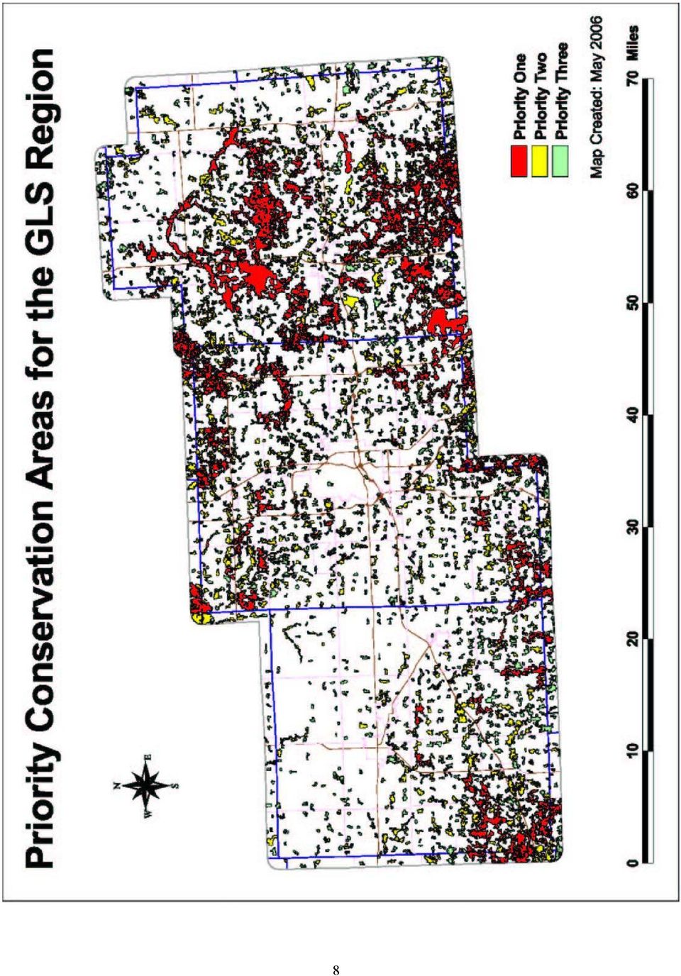
10 Note: The number of points assigned for each criterion is in the site criteria table on page 13. An element occurrence is an occurrence record of a federally and/or state listed species, state special concern species, exemplary and/or rare natural community, or another type of natural feature such as a unique geologic formation or bird colony. Priority Rankings for the GLS Region Potential Conservation Areas were tallied for the GLS region as well as within each county. The tally of PCA s for the GLS region includes all of the PCA s within each county as well as those located within a one-kilometer buffer zone around each county. Only those PCA s which originate in one of the three counties and extend into the buffer zone were included in this analysis for the region. Those PCA s which are entirely outside of any of the three counties were not included. The analysis for each county only included the portion of the PCA s that were contained within the county and did not include any portion of the PCA that extended into the buffer area. PCA s that straddle more than one county were divided at the county line and were counted within each county. Thus, the sum of the PCA s for the three counties will be greater than the number of PCA s in the GLS region. A total of 1,815 sites, totaling 250,471 acres were identified as potential conservation areas (PCA s) in the GLS Region. The acreage for only the portion of the PCA s that are completely contained within one of the three counties totals 229,878. This represents 19% of the total land base in the three-county area. Each of the 1,815 delineated sites was scored based upon the criteria described in the following table. Total scores ranged from a high of 35 points (out of a possible 41 points) to a low of 2 points. The mean score was nine. The top three sites are all located in Lapeer County. The site that received the highest score of 35 is located in Lapeer County in the Lapeer State Game Area. It is located along the South Branch of the Flint River at the junction of Marathon, Deerfield, Mayfield and Oregon Townships. It includes 5,778 acres in total size, with a core area of 3,572 acres. The site with the second highest score of 31 is also located in the Lapeer State Game area in Mayfield, Arcadia, North Branch and Deerfield Townships. It is bounded on the west by Highway 24 and on the east by Pleasant Lake Road. It encompasses 8,520 acres in total size with a core area of 3,090 acres. The site with the third highest score of 29 straddles Lapeer and Genesee Counties (primarily in Lapeer) and includes a large wetland complex along Hasler Creek near a concentration of small lakes and streams south of the Holloway Reservoir. The Genesee County Parks and Recreation Department own a large portion of this site. This site includes 4,347 acres in total size and has a core area of 892 acres. 6

11 Once the total scores were tabulated, the next step was to determine a logical and reasonable break between high priority, medium priority, and low priority sites. Many potential natural area sites can be just one point away from being placed into another category. Natural break and equal interval classification are two legitimate methods for classifying sites. Equal interval classification, as defined for this project, is based on absolute values. It shows the value of each site relative to the highest (41) and lowest (1) possible values. Equal interval classification breaks all possible scores into equal classes regardless of actual scores. This eliminates the relative nature of scores when sites are compared only to other sites within a given area. The natural break method is the default classification method in ArcView. This method identifies breakpoints between classes using a statistical formula called Jenk s optimization. The Jenk s method finds groupings and patterns inherent in the data by minimizing the sum of the variance within each of the classes. Based on the results of each method, MNFI recommends using the natural break method for the GLS Region. If the equal interval system were used, 48.5% of the total acres and 92% of the sites would fall into the priority three category. As a result of applying the natural break method, 819 sites were placed in the low priority category, 895 sites were placed in the middle category, and 101 sites were placed in the high priority category. Breaking it down into percentages of total sites identified, 45% were labeled low priority, 49% were labeled medium priority, and 6% of the sites were identified as high priority. Breaking it down by acreage, 19% (47,463 acres) fell into the low quality category, 33% (82,936 acres) fell into the medium quality category, and 48% (120,073 acres) fell into the high priority category. Lapeer County contains the highest number of acres (64,625) of high priority sites in the GLS region. These 64,625 acres represent 54% of the total area of high priority sites. Despite the more methodical approach to classification, it still could be argued that sites scoring one point below should be included in the higher category or that sites scoring right at the low end of a category should be placed in the next lowest category. To help alleviate anxieties about which category a particular site is placed, actual numeric total scores can be displayed in the middle of each polygon. This would allow the viewer to see how a site compares directly to another site without artificially categorizing it within a group Points 9 14 Points 2 8 Points Priority One Priority Two Conservation Priorities Priority Three 7

12 8
13 9

14 Priority Rankings for Genesee County In Genesee County, there were 754 sites, totaling 77,041 acres that were identified as potential conservation areas. This represents 18.5 % of the total area in the county. Each of the 754 delineated sites was given a total score based upon the criteria described in the following table. Total scores ranged from a high of 29 points (out of a possible 41 points) to a low of 2 points. The mean score was 10. The site that received the highest score of 29 straddles Lapeer and Genesee Counties (primarily in Lapeer) and includes a large wetland complex along Hasler Creek in the vicinity of a concentration of small lakes and streams south of the Holloway Reservoir. The Genesee County Parks and Recreation Department own a large portion of this site in Richfield Township. It includes 4,347 acres in total size and a core area of 892 acres. The site with the second highest score of 27 also straddles Genesee and Lapeer County. It is located in the southeast part of Genesee County in Atlas Township although most of the conservation area is in Lapeer County in Hadley Township. It includes the wetland complex along Kearsley Creek and the natural areas in the Ortonville State Recreation Area. It encompasses 4,973 acres in total size and a core area of 3,050 acres. The site with the third highest score of 25 is located in southwestern Genesee County in Argentine township along the Shiawassee River. This area extends into Shiawassee and Livingston counties. It is 4,412 acres in total size and has a core area of 1,109 acres. As a result of applying the natural break method, 294 sites were placed in the low priority category, 413 sites were placed in the medium category, and 47 sites were placed in the high priority category. Breaking it down into percentages of total sites identified, 39% were labeled low priority, 55% were labeled medium priority, and 6% of the sites were identified as high priority. Breaking it down by acreage, 20 % (15,643 acres) fell into the low quality category, 44 % (33,594 acres) fell into the medium quality category, and 36 % (27,805 acres) fell into the high priority category Points 9 14 Points 2 8 Points Priority One Priority Two Priority Three 10
 and includes a large wetland complex along Hasler Creek in the vicinity of a concentration")
15 11

16 Priority Rankings for Lapeer County In Lapeer County, there were 607 sites, totaling 108,030 acres that were identified as potential conservation areas. This represents 25.5 % of the total area in the county. Each of the 607 delineated sites was given a total score based upon the criteria described in the following table. Total scores ranged from a high of 35 points (out of a possible 41 points) to a low of 3 points. The mean score was nine. The three sites that scored the highest for the GLS Region all occur in Lapeer County. The site that received the highest score of 35 is located in the Lapeer State Game Area. It is bordered on its western side by the South Branch of the Flint River and is bounded on the east by Hwy 24. It is located in Marathon, Deerfield, Mayfield and Oregon Townships. It is 5,778 acres in total size, with a core area of 3,572 acres. The second highest-ranking site in the county (31) is also located in the Lapeer State Game Area. It is bounded on the west by Hwy 24 and on the east by Pleasant Lake Road. It is located in Mayfield, Arcadia, North Branch and Deerfield Townships. It encompasses 8,520 acres in total size with a core area of 3,090 acres. The third highestranking site includes a large wetland complex along Hasler Creek that occurs in the vicinity of a concentration of small lakes and streams south of the Holloway Reservoir and north of I-69. This site extends into Genesee County although most of the site is in Lapeer County. The Genesee County Parks and Recreation Department owns a large portion of this site in Richfield Township. This area is 4,347 acres in total size and has a core area of 892 acres. As a result of applying the natural break method, 277 sites were placed in the low priority category, 286 sites were placed in the medium category, and 44 sites were placed in the high priority category. Breaking it down into percentages of total sites identified, 46 % were labeled low priority, 47 % were labeled medium priority, and 7 % of the sites were identified as high priority. Breaking it down by acreage, 14 % (14,906 acres) fell into the low quality category, 26 % (28,499 acres) fell into the medium quality category, and 60 % (64,625 acres) fell into the high priority category Points 9 14 Points 2 8 Points Priority One Priority Two Priority Three 12

17 13

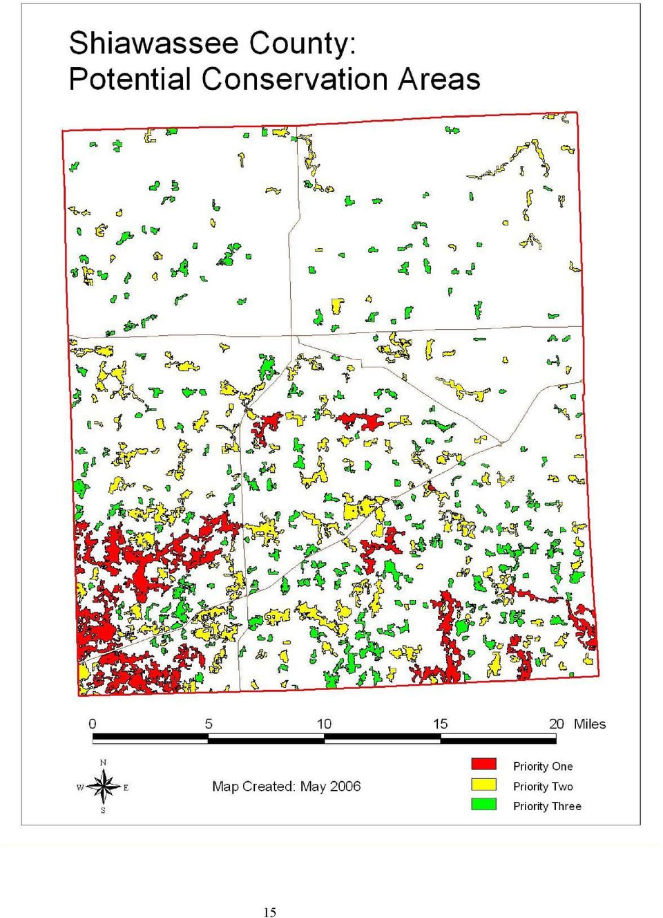
18 Priority Rankings for Shiawasee County In Shiawassee County there were 469 sites totaling 44,808 acres that were identified as potential conservation areas. This represents 13 % of the total area of the county. Each of the 469 delineated sites was given a total score based upon the criteria described in the following table. Total scores ranged from a high of 27 points (out of a possible 41 points) to a low of 3 points. The mean score was eight. The site that received the highest score of 27 is located in the southwestern part of the county in Sciota Township along the Looking Glass River. It includes a total area of 3,897 acres and a core area of 1,229 acres. The site with the second highest score of 26 is located in the southwestern corner of the county in Woodhull Township in the Rose Lake State Wildlife Research Area. Part of this area extends into Clinton County. The total acreage of this area is 3,235 acres with a core area of 971 acres. The third highest scoring site (25) is located the southeastern part of the county in Burns Township where the Shiawassee River splits into the north and south branches near the town of Byron. This conservation area extends into Genesee County where the majority of this site is located. The total acreage is 4,412 acres with a core area of 1,109 acres. As a result of applying the natural break method, 253 sites were placed in the low priority category, 201 sites were placed in the medium category, and 15 sites were placed in the high priority category. Breaking it down into percentages of total sites identified, 54 % were labeled low priority, 43 % were labeled medium priority, and 3% of the sites were identified as high priority. Breaking it down by acreage, 31 % (13,824 acres) fell into the low quality category, 41 % (18,256 acres) fell into the medium quality category, and 3 % (12,727 acres) fell into the high priority category Points 9 14 Points 2 8 Points Priority One Priority Two Priority Three 14

19 15
20 Table 1. Site Criteria CRITERIA DESCRIPTION DETAIL PTS Total Size Total size of the polygon in acres ac. Size is recognized as an important factor for viability of > species and ecosystems. ac. > ac. >240 ac. 4 Size of Core area Acres of core area. - Defined as total area minus 300 ft. buffer from edge of polygon. Greater core area limits negative impacts on edgesensitive animal species. 0-60ac 0 > ac > ac >230 ac 8 Stream Corridor (length) Landscape Connectivity Percentage Proximity Restorability of surrounding lands Length of a stream or river within the polygon. 0 0 >0-400 m 1 Stream corridors provide wildlife connections between patches of habitat. > m 2 > m > m >3200 m 6 Percentage of potential conservation areas within 1/4 mile. 0-11% 0 - build 1/4 mile buffer > measure % of buffer that is a potential conservation area 22% > % >33% 4 Number of potential conservation areas within 100 ft Connectivity between habitat patches is considered a 3 3 critical factor for wildlife health Restorability of surrounding lands within 1/4 mi. 0-35% 1 - build 1/4 mile buffer > subtract potential conservation areas from buffer 65% - measure % agricultural lands and old fields >65% 3 Restorability is important for increasing size of existing natural communities, providing linkages to other habitat patches, and providing a natural buffer from development. 16
 Landscape Connectivity Percentage Proximity Restorability of surrounding lands Length of a stream or river within the polygon.")
21 CRITERIA DESCRIPTION DETAIL PTS Vegetation Quality Percentage Estimates the quality of vegetation based on circa 1800 vegetation maps and 2000 IFMAP land cover data (only done for Michigan sites). Measures the percentage of potentially unchanged vegetation within a polygon. 1-10% % % % 4 Area Measures the actual area within a polygon of potentially unchanged vegetation regardless of the size of the polygon. 0 10ac ac 1 The quality of vegetation is critical to determining the ac 2 quality of a natural area Bio Rarity Score Known element occurrences increase the significance of a site and increase the bio rarity score. The location of quality natural communities and rare species tracked by MNFI are often, although not always, indicative of the quality of a site. > 160ac Values were determined using the Jenk s optimization formula. Note Total possible points = 41 Table 2. Results of PCA Analysis for Each County County # Sites Total Acres Core Area % Area Genesee ,041 18, % Lapeer ,030 29, % Shiawassee ,808 10,515 13% 17
22 Greenlinks flow chart for PCA model Remove all rivers, and water that isn't completely surrounded by natural land. Intersect with major roads. PCA Theme (defined as forest, or wetland, and water as described) Element Occurrence theme With Bio Rarity score PCA buffered by 30 meters PCA buffered by 0.25 miles PCA buffered by -300 ft Sum the Rarity score of EOs that intersect each PCA Find natural land cover % and restorable % w/in 0.25 mi. Count PCAs within 30 meters of each PCA Restorable land theme, (created from grassland, ag, shrub). Find stream length in PCAs. Stream theme (Nhd100.shp) Calculate Core Area Calculate % of PCA that is unchanged from circa 1800 Unchanged vegetation Calculate acres of unchanged vegetation in PCA Output PCA theme with criteria values, subtotals, and total scores. Total scores for each criteria 18
23 Conclusion This inventory documents that GLS Region has several high quality natural areas that still look and function the way they did 200 years ago. Of the remaining high quality sites, some have the potential of harboring endangered, threatened, or special concern animal and plant species. With the high rate of development and its associated stresses on the natural environment, conservation of these remaining areas and their native plant and animal populations are vital if the Region s diverse, natural heritage is to be conserved. When using this information it is important to keep in mind that site boundaries and rankings are a starting point and tend to be somewhat general in nature. Consequently, each community, group or individual using this information should determine what additional expertise is needed in order to establish more exact boundaries and the most appropriate conservation efforts. Comments/Recommendations 1) Local units of government, individuals and interest groups using this information should consult a publication produced by SEMCOG in 2003 entitled, Land use Tools and Techniques. The publication includes information on tools and techniques that conserve natural resources and create open space linkages while allowing for economically viable development. 2) Municipalities should identify opportunities to link other possible natural resource sites not mapped during this survey. This would include small patches of land, tree and fence row plantings, agriculture land, and open fields (greenways). 3) Field inventories should be conducted on identified potential conservation areas. This fieldwork would provide much needed additional site-specific data that should be considered when developing in and around such areas. 4) All identified sites, regardless of their priority, have significance to their local setting. This is especially true in areas that have experienced a high degree of development and landscape fragmentation. 5) A direct relationship exists between natural area protection and long-term water quality. With the abundance of water resources found in the GLS Region and the potential impact on the economy associated with degradation of these resources, natural area protection should be integrated into local water quality management plans. 6) Municipalities should work together and adopt a comprehensive green infrastructure plan. The conservation of critical natural areas is most effective, and successful, in the context of an overall plan. 7) Funding should be secured to update the mapping and assessment of this project s potential conservation areas approximately every three to five years. 19
24 8) Efforts to conserve potential conservation areas should include on-going site assessment and stewardship. 9) Local units of government in Genesee, Lapeer and Shiawassee Counties should undertake widespread distribution of this information in order to build awareness and encourage longterm resource planning and stewardship. Knowledge of potential conservation areas is meaningless unless action is taken to ensure that they will remain part of this area s natural heritage. 10) When establishing sites for possible field inventory, each community, group or individual should consider all available criteria in conjunction with their unique local conditions. Site selection may well be influenced by local growth pressure and ownership of the land. References Dale, V. H., S. Brown, R. A. Haeuber, N. T. Hobbs, N. Huntly, R. J. Naiman, W. E. Riebsame, M. G. Turner, and T. J. Valone Ecological Society of American Report: Ecological Principles and Guidelines for Managing the Use of Land. Ecological Applications. 10(3): Dramstad, Wenche E., J. D. Olson, and R. T. T. Forman Landscape Ecology Principles in Landscape Architecture and Land-Use Planning. Island Press, Washington, D.C. Forman, Richard T. T. and Michel Gordon Landscape Ecology. Wiley, New York. Leach, M. K. and T.J. Givnish Ecological Determinants of Species Loss in Remnant Prairies. Science. Vol. 273: Peck, Sheila Planning for Biodiversity: Issues and Examples. Island Press, Washington, D.C. Rosenberg, K. V., R. W. Rohrbaugh, Jr., S. E. Barker, J. D. Lowe, R. S. Hames and A. A. Dhondt A land managers guide to improving habitat for scarlet tanagers and other forest interior birds. The Cornell Lab of Ornithology. 20
GENESEE LAPEER SHIAWASSEE COUNTIES
 GENESEE LAPEER SHIAWASSEE COUNTIES Introduction Natural resource conservation is a fundamental component of a community s long-term environmental and economic health. Our natural areas perform important
Natural Resource-Based Planning*
 Natural Resource-Based Planning* Planning, when done well, is among the most powerful tools available to communities. A solid plan, based on good natural resource information, guides rational land-use
WEED MANAGEMENT PLAN FOR. (NAME of PROPERTY or MANAGED AREA) (TOWN or COUNTY, STATE) (TIME PERIOD; e.g. 1996-2000)
 (TOWN or COUNTY, STATE) (TIME PERIOD; e.g. 1996-2000)") (WEED MANAGEMENT PLAN OUTLINE FOR PUBLIC LAND MANAGERS) (Note: This outline is a modification of a weed management plan template produced by The Nature Conservancy) WEED MANAGEMENT PLAN FOR (NAME of PROPERTY
(WEED MANAGEMENT PLAN OUTLINE FOR PUBLIC LAND MANAGERS) (Note: This outline is a modification of a weed management plan template produced by The Nature Conservancy) WEED MANAGEMENT PLAN FOR (NAME of PROPERTY
SANTA BARBARA COUNTY COMPREHENSIVE PLAN LOMPOC AREA
 SANTA BARBARA COUNTY COMPREHENSIVE PLAN LOMPOC AREA A. LAND USE ELEMENT INTERPRETIVE GUIDELINES B. COMMUNITY BENEFITS C. COUNTY ACTION ITEMS Adopted by the Board of Supervisors November 9, 1999 A. Santa
LIVING LANDS Helping Land Trusts Conserve Biodiversity
 LIVING LANDS Helping Land Trusts Conserve Biodiversity Land Trust Biodiversity Survey, Winter 2006 Purpose of Survey To better understand local land trusts current activities and interest in biodiversity
How To Plan A Buffer Zone
 Backyard Buffers Protecting Habitat and Water Quality What is a buffer? A buffer (also called a riparian buffer area or zone) is the strip of natural vegetation along the bank of a stream, lake or other
Prioritizing Riparian Restoration at the Watershed, Reach and Site Scales. Richard R. Harris University of California, Berkeley Cooperative Extension
 Prioritizing Riparian Restoration at the Watershed, Reach and Site Scales Richard R. Harris University of California, Berkeley Cooperative Extension Issues Riparian communities provide multiple benefits
UPPER COLUMBIA BASIN NETWORK VEGETATION CLASSIFICATION AND MAPPING PROGRAM
 UPPER COLUMBIA BASIN NETWORK VEGETATION CLASSIFICATION AND MAPPING PROGRAM The Upper Columbia Basin Network (UCBN) includes nine parks with significant natural resources in the states of Idaho, Montana,
Colorado Natural Heritage Program
 CNHP s mission is to preserve the natural diversity of life by contributing the essential scientific foundation that leads to lasting conservation of Colorado's biological wealth. Colorado Natural Heritage
Revising the Nantahala and Pisgah Land Management Plan Preliminary Need to Change the Existing Land Management Plan
 Revising the Nantahala and Pisgah Land Management Plan Preliminary Need to Change the Existing Land Management Plan Throughout the Plan 1. There is a fundamental need for the revised plan to address how
1.7.0 Floodplain Modification Criteria
 1.7.0 Floodplain Modification Criteria 1.7.1 Introduction These guidelines set out standards for evaluating and processing proposed modifications of the 100- year floodplain with the following objectives:
Michigan Wetlands. Department of Environmental Quality
 Department of Environmental Quality Wetlands are a significant component of Michigan s landscape, covering roughly 5.5 million acres, or 15 percent of the land area of the state. This represents about
4.2 Buena Vista Creek Watershed
 Buena Vista Creek Watershed 4.2 Buena Vista Creek Watershed Watershed Overview The Buena Vista Creek Watershed is the fourth-largest system within the Carlsbad Hydrologic Unit. The watershed extends approximately
COASTAL MONITORING & OBSERVATIONS LESSON PLAN Do You Have Change?
 Coastal Change Analysis Lesson Plan COASTAL MONITORING & OBSERVATIONS LESSON PLAN Do You Have Change? NOS Topic Coastal Monitoring and Observations Theme Coastal Change Analysis Links to Overview Essays
Wildlife Habitat Conservation and Management Plan
 Wildlife Habitat Conservation and Management Plan For [Applicant Name] [Insert photo of property] Developed in Cooperation with Jane Doe Habitat Conservation Biologist Oregon Department of Fish and Wildlife
Addendum D. Nomination of Moody Wash ACEC
 Addendum D Nomination of Moody Wash ACEC Moody Wash ACEC is hereby nominated by Citizens for Dixie s Future to: BLM St. George Field Office 345 East Riverside Drive St. George, UT 84790 Moody Wash is a
High Conservation Value Forests 3.1. Old Growth Forests. Management & Monitoring Framework
 High Conservation Value Forests 3.1 Old Growth Forests Management & Monitoring Framework HCV 3: Forest areas that are in or contain rare, threatened or endangered ecosystems. HCVF 3.1 Old Growth Areas
Post-Wildfire Clean-Up and Response in Houston Toad Habitat Best Management Practices
 Post-Wildfire Clean-Up and Response in Houston Toad Habitat Best Management Practices Purpose The purpose of this document is to provide guidance and recommendations for minimizing potential impacts to
FORESTED VEGETATION. forests by restoring forests at lower. Prevent invasive plants from establishing after disturbances
 FORESTED VEGETATION Type of strategy Protect General cold adaptation upland and approach subalpine forests by restoring forests at lower Specific adaptation action Thin dry forests to densities low enough
4. Priority Areas of Conservation
 4. Priority Areas of Conservation A. SIGNIFICANT RESOURCE AREAS This Open Space and Farmland Plan identifies the key issues facing open space and agricultural resources in the Town, highlights the location
Lower Crooked Creek Watershed Conservation Plan EXECUTIVE SUMMARY
 EXECUTIVE SUMMARY Project Background Located in southwestern Pennsylvania, Crooked Creek is a major tributary of the Allegheny River, entering near Ford City in Armstrong County. It is rich in natural
Using Aerial Photography to Measure Habitat Changes. Method
 Then and Now Using Aerial Photography to Measure Habitat Changes Method Subject Areas: environmental education, science, social studies Conceptual Framework Topic References: HIIIB, HIIIB1, HIIIB2, HIIIB3,
Michigan Department of Natural Resources Oil and Gas Leases Frequently Asked Questions
 What is the DNR s authority for leasing oil and gas? How are state-owned oil and gas rights leased? Who decides which state-owned oil and gas rights will be offered for lease at the auction? How often
A Developer s Guide: Watershed-Wise Development
 A Developer s Guide: Watershed-Wise Development Environmental Protection What is a watershed? It does not matter how far away you build from a creek, lake, or the ocean, you are in a watershed. Another
GreenPlanIT LID Site Suitability Tool. Patty Frontiera, pattyf@sfei.org Pete Kauhanen, petek@sfei.org Marshall Kunze, marshallk@sfei.
 GreenPlanIT LID Site Suitability Tool Patty Frontiera, pattyf@sfei.org Pete Kauhanen, petek@sfei.org Marshall Kunze, marshallk@sfei.org GreenPlanIT TAC Meeting, 06/17/2014 LID Site Suitability Tool Talk
Decision Memo. Restore Act Land Acquisition
 Decision Memo Restore Act Land Acquisition USDA Forest Service National Forests in Mississippi Background A broad coalition of federal. state, and municipal government agencies and private conservation
RESTORATION & REVITALIZATION
 RESTORATION & REVITALIZATION Legal preservation has not proved to be sufficient to preserve natural communities. Restoration activities are diverse and includes revitalization of natural communities which
Land Disturbance, Erosion Control and Stormwater Management Checklist. Walworth County Land Conservation Department
 Land Disturbance, Erosion Control and Stormwater Management Checklist Walworth County Land Conservation Department The following checklist is designed to assist the applicant in complying with the Walworth
Pennsylvania Energy Impacts Assessment Executive Summary
 Pennsylvania Energy Impacts Assessment Executive Summary: Marcellus Shale Natural Gas and Wind Energy Nels Johnson, The Nature Conservancy, Pennsylvania Chapter Executive Summary Forest landscape along
Chapter 1b - Priority Map Development
 North Carolina s Forest Resources Assessment A statewide analysis of the past, current and projected future conditions of North Carolina s forest resources 2010 Chapter 1b - Priority Map Development This
Corridor Goals and Objectives
 Corridor Goals and Objectives This chapter presents the goals and objectives, developed by the Corridor Study Committee, that serve as the purpose and intent of the Corridor Plan. This plan covers a twenty
Appendix A: Land Protection Plan
 Appendix A: Land Protection Plan In this appendix A.1 Introduction and Purpose A.2 Project Description A.3 Refuge Purposes A.4 Land Acquisition Policy for Urban Refuges A.5 Status of Resources to be Protected
understanding Sustainable Landscaping & Tree Preservation Standards
 understanding Sustainable Landscaping & Tree Preservation Standards Purpose To promote landscaping around development that is compatible with the existing environment, and which reduces greenhouse gas
MAPPING MINNEAPOLIS URBAN TREE CANOPY. Why is Tree Canopy Important? Project Background. Mapping Minneapolis Urban Tree Canopy.
 MAPPING MINNEAPOLIS URBAN TREE CANOPY Why is Tree Canopy Important? Trees are an important component of urban environments. In addition to their aesthetic value, trees have significant economic and environmental
Risk Analysis, GIS and Arc Schematics: California Delta Levees
 Page 1 of 7 Author: David T. Hansen Risk Analysis, GIS and Arc Schematics: California Delta Levees Presented by David T. Hansen at the ESRI User Conference, 2008, San Diego California, August 6, 2008 Abstract
COMPREHENSIVE PLAN SECTION B, ELEMENT 4 WATER RESOURCES. April 20, 2010 EXHIBIT 1
 COMPREHENSIVE PLAN SECTION B, ELEMENT 4 WATER RESOURCES April 20, 2010 EXHIBIT 1 ELEMENT 4 WATER RESOURCES TABLE OF CONTENTS 4.1 INTRODUCTION 4.2 GOALS AND POLICIES 4.2.A General Goals and Policies 1 4.2.B
Wildlife Habitat Conservation and Management Program
 Wildlife Habitat Conservation and Management Program Manual for Counties and Cities Oregon Department of Fish and Wildlife 2015 Table of Contents 1. Introduction Purpose of the habitat program Objective
GLOSSARY OF TERMS CHAPTER 11 WORD DEFINITION SOURCE. Leopold
 CHAPTER 11 GLOSSARY OF TERMS Active Channel The channel that contains the discharge Leopold where channel maintenance is most effective, sediment are actively transported and deposited, and that are capable
March 2008. Prepared by: Irvine Ranch Water District. 15600 Sand Canyon Avenue. Irvine, CA 92618. Contact: Natalie Likens (949) 453-5633
 453-5633") ADDENDUM TO THE MICHELSON WATER RECLAMATION PLANT PHASE 2 & 3 CAPACITY EXPANSION PROJECT FEBRUARY 2006 FINAL ENVIRONMENTAL IMPACT REPORT AND THE SAN JOAQUIN FRESHWATER MARSH ENHANCEMENT PLAN REVISED SEPTEMBER
ADDENDUM TO THE MICHELSON WATER RECLAMATION PLANT PHASE 2 & 3 CAPACITY EXPANSION PROJECT FEBRUARY 2006 FINAL ENVIRONMENTAL IMPACT REPORT AND THE SAN JOAQUIN FRESHWATER MARSH ENHANCEMENT PLAN REVISED SEPTEMBER
INSTRUCTIONS FOR COMPLETING COMPONENT 1 EXCEPTION TO THE REQUIREMENT TO REVISE THE OFFICIAL PLAN
 COMMONWEALTH OF PENNSYLVANIA DEPARTMENT OF ENVIRONMENTAL PROTECTION BUREAU OF WATER STANDARDS AND FACILITY REGULATION Remove and recycle these instructions before mailing component to the approving agency
Flood Plain Reclamation to Enhance Resiliency Conserving Land in Urban New Jersey
 Flood Plain Reclamation to Enhance Resiliency Conserving Land in Urban New Jersey Rutgers Cooperative Extension Water Resources Program Christopher C. Obropta, Ph.D., P.E. Email: obropta@envsci.rutgers.edu
Experienced Planning and Design
 www.pizzo.info Consistently Better Natural Restoration Everyone should have a passion in life, and for me it s been to protect and restore our lands to their original native beauty. That s why in 1988
Goal 1 To protect the public health, safety and property from the harmful effects of natural disasters.
 Plan Framework for Coastal Management The purpose of this element is to provide for the protection of residents and property in within the coastal area of the host community, and to limit expenditures,
Integration of Forestry & Wildlife Management
 Integration of Forestry & Wildlife Management By Ken Negray Regional Certification Manager, NewPage Corp & member of the KY SIC Committee Abstract: Kentucky SIC (Sustainable Forestry Initiative Implementation
Clean Water Services. Ecosystems Services Case Study: Tualatin River, Washington
 Viewed broadly, the concept of ecosystem services describes the many resources and services provided by nature. Typically, traditional planning and development practices do not adequately represent the
Multiple Species Conservation Program County of San Diego. A Case Study in Environmental Planning & The Economic Value of Open Space
 Multiple Species Conservation Program County of San Diego A Case Study in Environmental Planning & The Economic Value of Open Space Amy M. Fox Land Use Law Case Study Autumn Semester, 1999 Multiple Species
Myre-Big Island State Park
 Myre-Big Island State Park Management Plan Amendment Resource Management Timber Harvesting Minnesota Department of Natural Resources Division of Parks and Trails May 2013 For more information on this management
Restoration Planning and Development of a Restoration Bank
 Restoration Planning and Development of a Restoration Bank Black Creek Pioneer Village, South Theatre 8:30 a.m. to 3:30 p.m. Habitat Restoration and Environmental Monitoring Projects Section Restoration
Adopted 9/23/98 CHATTAHOOCHEE CORRIDOR PLAN. The goals of the Chattahoochee Corridor Plan (hereinafter also referred to as the Plan ) are:
 are:") CHATTAHOOCHEE CORRIDOR PLAN Adopted 9/23/98 PART 1: GOALS. POLICY. COVERAGE. A. Goals The goals of the Chattahoochee Corridor Plan (hereinafter also referred to as the Plan ) are: 1. Preservation and protection
CHATTAHOOCHEE CORRIDOR PLAN Adopted 9/23/98 PART 1: GOALS. POLICY. COVERAGE. A. Goals The goals of the Chattahoochee Corridor Plan (hereinafter also referred to as the Plan ) are: 1. Preservation and protection
Background research on the topic of urban forestry is intended to
 overview urban forestry Urban Forestry Background research on the topic of urban forestry is intended to help guide the task of integrating trees and urban forestry goals and aspirations into the Portland
Natural Gas Pipelines
 Natural Gas Pipelines Excerpt from Report 2 of the Pennsylvania Energy Impacts Assessment December 16, 2011 Authors: Nels Johnson, Tamara Gagnolet, Rachel Ralls, and Jessica Stevens The Nature Conservancy
FLOOD PROTECTION AND ECOSYSTEM SERVICES IN THE CHEHALIS RIVER BASIN. May 2010. Prepared by. for the. 2010 by Earth Economics
 FLOOD PROTECTION AND ECOSYSTEM SERVICES IN THE CHEHALIS RIVER BASIN May 2010 Prepared by for the Execubve Summary The Chehalis Basin experienced catastrophic flooding in 2007 and 2009. In response, the
Objectives. Raster Data Discrete Classes. Spatial Information in Natural Resources FANR 3800. Review the raster data model
 Spatial Information in Natural Resources FANR 3800 Raster Analysis Objectives Review the raster data model Understand how raster analysis fundamentally differs from vector analysis Become familiar with
AN INITIATIVE TO IMPROVE
 L OW E R C A R M E L R I V E R A N D L AG O O N F L O O D P L A I N R E S TO R AT I O N A N D E N H A N C E M E N T P R O J E C T AN INITIATIVE TO IMPROVE FLOOD PROTECTION RESTORE AND PROTECT RIPARIAN
Forest Management Guidelines for the Protection of Four-toed and Spotted Salamander Populations Carol Hall & Bruce Carlson May 2004
 Forest Management Guidelines for the Protection of Four-toed and Spotted Salamander Populations Carol Hall & Bruce Carlson May 2004 Salamander Natural History Four-toed Salamanders: The Four-toed Salamander,
CHAPTER I: INTRODUCTION. Background
 CHAPTER I: INTRODUCTION Background California State Law requires each county to adopt a General Plan for the physical development of the county and any land outside its boundaries which bears relation
JACIE Science Applications of High Resolution Imagery at the USGS EROS Data Center
 JACIE Science Applications of High Resolution Imagery at the USGS EROS Data Center November 8-10, 2004 U.S. Department of the Interior U.S. Geological Survey Michael Coan, SAIC USGS EROS Data Center coan@usgs.gov
Backyard Buffers that Work for People and Nature by Restoring Ecological Function
 Backyard Buffers that Work for People and Nature by Restoring Ecological Function What is a Wetland Buffer? A wetland buffer is a simple land management practice that is employed by municipalities to protect
Michigan Tech Research Institute Wetland Mitigation Site Suitability Tool
 Michigan Tech Research Institute Wetland Mitigation Site Suitability Tool Michigan Tech Research Institute s (MTRI) Wetland Mitigation Site Suitability Tool (WMSST) integrates data layers for eight biophysical
Biodiversity Concepts
 Biodiversity Concepts WHAT IS BIODIVERSITY? Biodiversity is the variety of life on Earth. For any kind of animal or plant each individual is not exactly the same as any other; nor are species or ecosystems.
Laws of Minnesota 2009 Final Report
 Lessard-Sams Outdoor Heritage Council Laws of Minnesota 2009 Final Report Dat e: August 20, 2013 Program or Project T it le: Habitat Protection, Phase 1 Funds Recommended: $1,000,000 Manager's Name: T
Recommended Land Use Guidelines for Protection of Selected Wildlife Species and Habitat within Grassland and Parkland Natural Regions of Alberta
 Fish and Wildlife Division Sustainable Resource Development Recommended Land Use Guidelines for Protection of Selected Wildlife Species and Habitat within Grassland and Parkland Natural Regions of Alberta
Pledge Supporting NJ Wildlife Action Plan
 Pledge Supporting NJ Wildlife Action Plan 10 Points 10 Points The Wildlife Action Plan Pledge is a community s first step in recognizing the important role that wild animals play in healthy, sustainable
Restoring Anadromous Fish Habitat in Big Canyon Creek Watershed. Summary Report 2002
 Restoring Anadromous Fish Habitat in Big Canyon Creek Watershed Summary Report 2002 DOE/BP-00005268-5 November 2002 This Document should be cited as follows: "Restoring Anadromous Fish Habitat in Big Canyon
Black Tern Distribution Modeling
 Black Tern Distribution Modeling Scientific Name: Chlidonias niger Distribution Status: Migratory Summer Breeder State Rank: S3B Global Rank: G4 Inductive Modeling Model Created By: Joy Ritter Model Creation
Thank you to all of our 2015 sponsors: Media Partner
 Thank you to all of our 2015 sponsors: Media Partner Channel Naturalization: Planning and Implementation in Peel Region TRIECA March 25 & 26, 2015 Peel Region Channel Remediation Strategy An Urban Context
13. ENVIRONMENTAL PROTECTION/ RESOURCE MANAGEMENT
 13. ENVIRONMENTAL PROTECTION/ RESOURCE MANAGEMENT A. Existing Conditions Ramsey is fortunate to have an ample amount of natural resources and open space areas and a community attitude that is increasingly
The Conservation Reserve Program: 45th Signup Results
 Farm Service Agency The Conservation Reserve Program: 45th Signup Results U.S Department of Agriculture Farm Service Agency Conservation and Environmental Program Division 1400 Independence Ave., SW, Room
HARDWICK TOWNSHIP WARREN COUNTY, NEW JERSEY
 HARDWICK TOWNSHIP WARREN COUNTY, NEW JERSEY AN ORDINANCE TO AMEND CHAPTER XIII OF THE REVISED GENERAL ORDINANCES BEING THE LAND DEVELOPMENT ORDINANCE OF THE TOWNSHIP OF HARDWICK TOWNSHIP IN ORDER TO ADOPT
Marchand Provincial Park. Draft Management Plan
 Marchand Provincial Park Draft Management Plan Marchand Provincial Park Draft Management Plan Table of Contents 1. Introduction... 3 2. Park History... 3 3. Park Attributes... 4 3.1 Natural... 4 3.2 Recreational...
Nature Values Screening Using Object-Based Image Analysis of Very High Resolution Remote Sensing Data
 Nature Values Screening Using Object-Based Image Analysis of Very High Resolution Remote Sensing Data Aleksi Räsänen*, Anssi Lensu, Markku Kuitunen Environmental Science and Technology Dept. of Biological
DRAFT Addendum to IVM Best Management Practices
 Integrated Vegetation Management on Pipeline Rights-of-Way Addendum to Best Management Practices: Integrated Vegetation Management Ryan Brockbank, Western Environmental Consultants, Inc. The intent of
Integrating Landscape Restoration and CWPP
 Integrating Landscape Restoration and CWPP Two approaches: One or more CWPP embedded in a larger landscape to achieve multiple objectives CWPP that encompasses a larger landscape to achieve multiple objectives
Technical Study and GIS Model for Migratory Deer Range Habitat. Butte County, California
 Technical Study and GIS Model for Migratory Deer Range Habitat, California Prepared for: Design, Community & Environment And Prepared by: Please Cite this Document as: Gallaway Consulting, Inc. Sevier,
COMMENCEMENT. Northwestern Indiana Regional
 The Northwest Indiana Regional Greenways and Blueways Plan was developed jointly by the Northwestern Indiana Regional Planning Commission (NIRPC) and the Openlands Project. Funding for the plan was provided
CONSERVING OUR RURAL ENVIRONMENT
 HUME CITY COUNCIL CONSERVING OUR RURAL ENVIRONMENT Grant Guidelines 2015 2016 hume.vic.gov.au CONTENTS 1. GRANT OVERVIEW 1 1.1 Program introduction 1 1.2 Who can apply? 1 1.3 Grant types 1 2. GRANT SELECTION
MICHIGAN S LANDSCAPE ARCHITECTS
 MICHIGAN S LANDSCAPE ARCHITECTS protecting the health, safety, and welfare of our citizens site design land use planning master planning streetscape design brownfield redevelopment guidelines and regulations
720 Contour Grading. General. References. Resources. Definitions
 720 Contour Grading General Contour grading directs water to a desired point, prevents erosion, provides noise deflection, provides visual fit of the facility into the landscape, and protects desirable
PUBLIC NOTICE Application for Permit
 PUBLIC NOTICE Application for Permit 30-Day Notice Issue Date: June 20, 2016 Expiration Date: July 20, 2016 US Army Corps of Engineers No: NWP-2010-535 Oregon Department of State Lands No: 58311-RF Interested
American Forest Foundation (AFF) 2010-2015 Standards of Sustainability for Forest Certification
 2010-2015 Standards of Sustainability for Forest Certification") American Forest Foundation (AFF) 2010-2015 Standards of Sustainability for Forest Certification Standards Prologue The American Forest Foundation s (AFF) 2010-2015 Standards of Sustainability for Forest
American Forest Foundation (AFF) 2010-2015 Standards of Sustainability for Forest Certification Standards Prologue The American Forest Foundation s (AFF) 2010-2015 Standards of Sustainability for Forest
Prattsville Berm Removal Project. 1.0 Project Location
 Prattsville Berm Removal Project 1.0 Project Location The project site is located between the New York State Route 23 Bridge over the Schoharie Creek and the Schoharie Reservoir. The restoration plan encompassed
ENVIRONMENT ACT PROPOSED TERMS OF REFERENCE FOR PUBLIC REVIEW AND COMMENT NOVA SCOTIA DEPARTMENT OF TRANSPORTATION AND PUBLIC WORKS
 ENVIRONMENT ACT PROPOSED TERMS OF REFERENCE FOR PUBLIC REVIEW AND COMMENT NOVA SCOTIA DEPARTMENT OF TRANSPORTATION AND PUBLIC WORKS Beaver Bank Bypass Highway 101 to the Beaver Bank Road Halifax County,
APPLICATION FOR CLASSIFICATION OF FOREST LAND
 To the Chief, Division of Forestry: APPLICATION FOR CLASSIFICATION OF FOREST LAND In accordance with sections 5713.22-.26 of the Ohio Revised Code, I hereby apply for the classification of certain lands
Briefing Paper on Lower Galveston Bay and Bayou Watersheds Lower Bay I: Armand Bayou to Moses Lake and Adjacent Bay Waters
 Briefing Paper on Lower Galveston Bay and Bayou Watersheds Lower Bay I: Armand Bayou to Moses Lake and Adjacent Bay Waters Jim Lester, PhD. and Lisa Gonzalez Houston Advanced Research Center Galveston
Appendix C. Municipal Planning and Site Restoration Considerations
 Appendix C Municipal Planning and Site Restoration Considerations 67 68 Appendix C - Municipal Planning and Site Restoration Considerations This appendix contains best practice standards for site planning
Lesson Overview. Biodiversity. Lesson Overview. 6.3 Biodiversity
 Lesson Overview 6.3 6.3 Objectives Define biodiversity and explain its value. Identify current threats to biodiversity. Describe how biodiversity can be preserved. THINK ABOUT IT From multicolored coral
As stewards of the land, farmers must protect the quality of our environment and conserve the natural resources that sustain it by implementing
 N A T U R A L R E S O U R C E C O N S E R V A T I O N As stewards of the land, farmers must protect the quality of our environment and conserve the natural resources that sustain it by implementing conservation
Land and Resource Management Plan Chattahoochee-Oconee National Forests
 United States Department of Agriculture Forest Service Southern Region Land and Resource Management Plan Chattahoochee-Oconee National Forests Management Bulletin R8-MB 113 A January 2004 The revision
Note on Draft Progress Report Template
 Note on Draft Progress Report Template The Draft Progress Report template is provided as a guide to applicants on possible reporting requirements for the Biodiversity Fund. This actual report will be provided
Resources, Publications, Tools, Input from AWCC
 A comprehensive review of Farm Bill contributions to wildlife conservation A comprehensive review was made of scientific literature to determine wildlife responses to conservation programs undertake as
THE SECRETARY OF THE INTERIOR WASHINGTON
 THE SECRETARY OF THE INTERIOR WASHINGTON ORDER NO. 3336 Subject: Rangeland Fire Prevention, Management and Restoration Sec. 1 Purpose. This Order sets forth enhanced policies and strategies for preventing
Heritage Place Code. Heritage Place Code
 1 Application This Code will apply in assessing building work (including demolition), reconfiguring a lot or operational work where: on a premises that includes a heritage place within a heritage precinct
LFA FORESTRY, FIRE, AND STATE LANDS I SSUE BRIEF UTAH STATE LEGISLATURE 2015 GENERAL SESSION. Summary
 UTAH STATE LEGISLATURE 2015 GENERAL SESSION LFA LEGISLATIVE FISCAL ANALYST FORESTRY, FIRE, AND STATE LANDS NATURAL RESOURCES, AGRICULTURE, & ENVIRONMENTAL QUALITY APPROPRIATIONS SUBCOMMITTEE STAFF: IVAN
www.basic.ncsu.edu/segap
 MANUAL FOR REVIEWING SE-GAP VERTEBRATE DATABASE/MODELS www.basic.ncsu.edu/segap TABLE OF CONTENTS TITLE PAGE IMPORTANT INFORMATION 1 OPENING THE DATABASE AND LOGGING IN 2 Opening the database, filling
Richmond City s Green Infrastructure Assessment
 Richmond City s Green Infrastructure Assessment Presented by Karen Firehock, Director The Green Infrastructure Center Inc. www.gicinc.org Mike Mather, City Arborist City of Richmond Winter Symposium --
Remaining Wetland Acreage 1,500,000 915,960 584,040-39%
 NEW JERSEY Original Wetland Acreage Remaining Wetland Acreage Acreage Lost % Lost 1,500,000 915,960 584,040-39% New Jersey Wetlands: Nearly 99 percent of New Jersey s wetlands are palustrine or estuarine.
Conservation Tax Credit Regulations Chapter 391-1-6 A-1 RULES OF GEORGIA DEPARTMENT OF NATURAL RESOURCES CHAPTER 391-1-6
 Conservation Tax Credit Regulations Chapter 391-1-6 A-1 RULES OF GEORGIA DEPARTMENT OF NATURAL RESOURCES CHAPTER 391-1-6 GEORGIA CONSERVATION TAX CREDIT PROGRAM TABLE OF CONTENTS 391-1-6-.01 Purpose and
Sustainability Brief: Water Quality and Watershed Integrity
 Sustainability Brief: and Watershed Integrity New Jersey depends on water resources for the health of our people, the strength of our economy, and the vitality of our ecosystems. The quality of our water
Arkansas River Corridor Vision & Master Plan
 A r k a n s a s R I v e r C o r r I d o r P l a n Arkansas River Corridor Vision & Master Plan July 2005 Indian Nations Council of Governments A r k a n s a s R I v e r C o r r I d o r P l a n Partnership
Using an All lands Framework for Conservation of Ecosystem Services
 Using an All lands Framework for Conservation of Ecosystem Services Robert Deal USDA Forest Service - PNW Research Station, Portland, OR Nikola Smith USDA Forest Service - Pacific Northwest Region, Portland,