Bipolar Atlantic Thermohaline Circulation (BIAC) a IPY proposal coordinated by Tor Gammelsrød Geophysical Institute, University of Bergen
|
|
|
- Preston Warren
- 8 years ago
- Views:
Transcription
1 Bipolar Atlantic Thermohaline Circulation (BIAC) a IPY proposal coordinated by Tor Gammelsrød Geophysical Institute, University of Bergen The role of the Thermohaline Circulation (THC) as a driving force for the ocean circulation, and therefore the global climate, is well acknowledged. The majority of the deep- and bottom- water production takes place in the Atlantic sector. The densest water ventilating the world ocean abyss is produced in the northern and southern extremes. When the dense water is cascading towards great depths, it mixes with surrounding water masses to produce the various brands of bottom water. The replacement of the surrounding water is believed to be an important driving force for the global THC. The BIAC concentrate on all aspects related to bottom water formation and THC in the past, present and future. Modelling and remote sensing are important tools, as well as in situ measurements that will require adequately equipped icebreakers and moorings.

2 Salinity Temperature

3 Bipolar Atlantic Thermohaline Circulation (BIAC) The aim of the proposed project is to study mechanisms, manifestations and impacts of bottom water formation on the bipolar Atlantic Ocean shelves. Key areas are the Barents Sea, and the southern Weddell Sea. Objectives Identify locations where dense water is formed (open ocean, shallow shelves) Study dense water formation processes; cooling, ice formation, convection Identify dense water pathways on shelves and in semi-closed basins Study the cascading of dense water towards the deep ocean. Define physical and biogeochemical controls on ocean carbon biogeochemistry Investigate relationships between variability in deep-water formation, CO2 uptake rates and large-scale natural or anthropogenic climate forcing Obtain paleo-records of dense-water formation rates

4 The Bipolar Atlantic Ocean Ventilation areas Key areas

5 Budget: 44.7 mil NOK

6
7 The Arctic Ocean ventilation area The Barents Sea Cruises Cruises

8 The Cradle of the Bi-polar Atlantic Ocean THC Bottom water The southern Weddell Sea... ISW + WDW = 4 Sv WSBW (-0.8 C) WSBW AABW 1.6 ± 0.5 Sv ISW (Foldvik et al 2004) DEEP WATER FORMATION IN THE WEDDELL SEA Filchner Depression CMR-IFIX Østerhus 9811
 DEEP WATER FORMATION IN THE")
9
10 Low latitude Downslope processes and Thermohaline Circulation Compensating flow Mixing Sv Vent.: 4-6 Sv Labrador Sea NADW 3 C Surface outflow 3 Sv Entrainment 12 Sv 6 Sv 6 C Atlantic inflow O v erfl ow Greenland Scotland Ridge Cooling 6 Sv Overflow Water 0 C Ventilation Upwelling Freshwater Arctic

11
12 IPY station on the Filchner-Ronne Ice shelf? The role played in the climate system by the interaction between the ocean and Antarctic ice shelves is a key issue regarding future climate changes. To establish a long term (several decades) monitoring station on the Filchner- Ronne Ice Shelf, in the southern Weddell Sea will be consider proposed under BIAC. Technology! IFIX Inductive Oceanographic Sensor Chain Atlantic Ocean Weddell Sea Ic e Sheet Antarc tica Pacific Ocean Ross Sea Controller and Dual Satellite Link Current Meter Salinity, Temperature and P ressure (CTP) Sensor
 monitoring station on the Filchner- Ronne Ice Shelf, in the southern Weddell Sea will be consider")
13 BIAC links to other IPY projects BIAC

14 BIAC IPY Cluster # 23

15 The Bipolar Atlantic Ocean THC/MOC Low latitude Surface outflow 3 Sv Cooling Freshwater Arctic Salinity Compensating flow Upwelling Mixing Sv Vent.: 4-6 Sv Labrador Sea NADW 3 C Entrainment 12 Sv 6 Sv 6 C Atlantic inflow O v erfl ow Greenland Scotland Ridge 6 Sv Overflow Water 0 C Ventilation 1000 Temperature

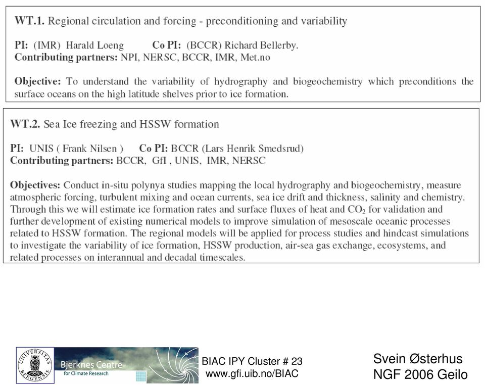
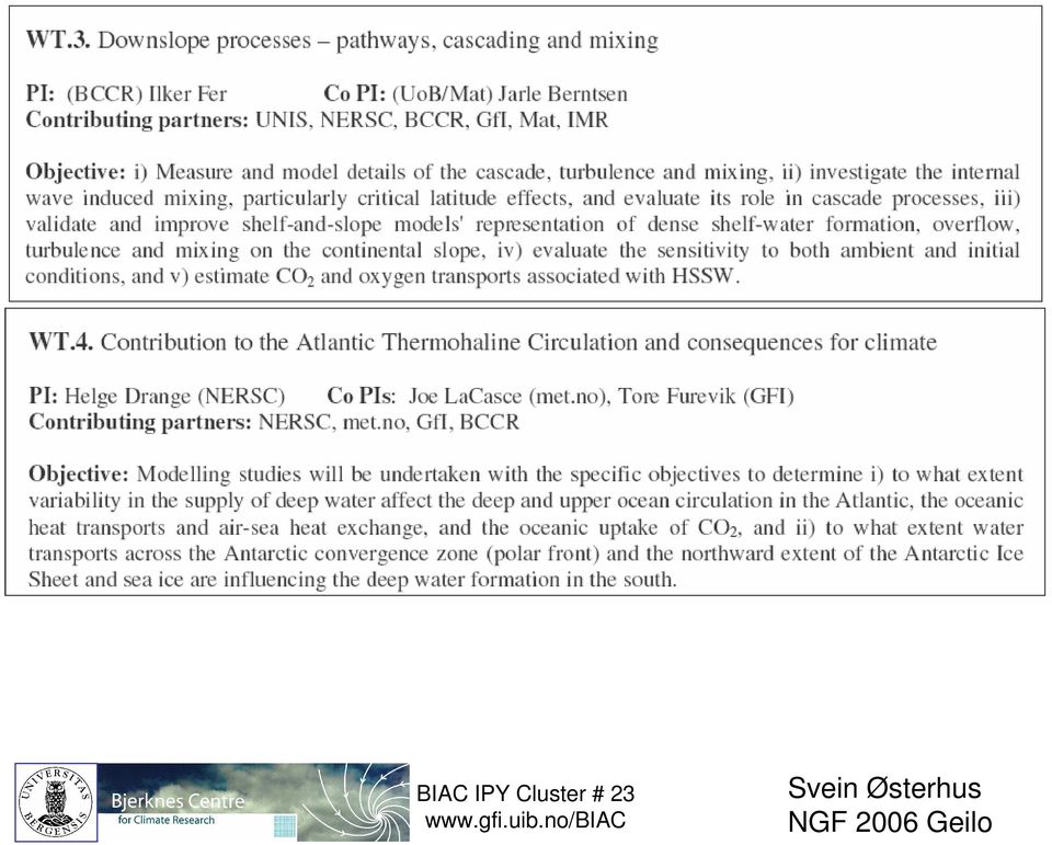
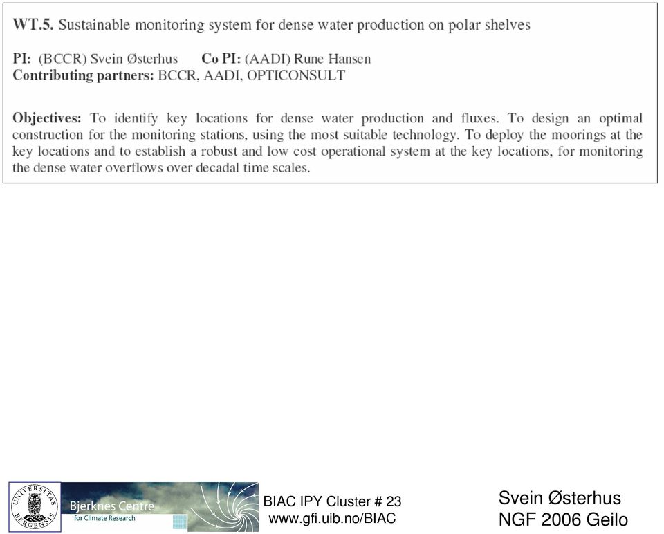
16 BIAC WT1. Regional circulation and forcing - preconditioning and variability WT2. Sea ice freezing and high-salinity shelf water (HSSW) formation WT3. Downslope processes pathways, cascading and mixing WT4. Contribution to the thermohaline circulation (THC) and consequences for the climate WT5. Future long term changes at key monitoring locations Budget 44.7 mill NOK
 and consequences for the climate WT5.")
ARI: The water-mass signature and pathways of Greenland Ice Sheet meltwater in the Arctic and North Atlantic as inferred by an inverse method
 Final Report ARI: The water-mass signature and pathways of Greenland Ice Sheet meltwater in the Arctic and North Atlantic as inferred by an inverse method Geoffrey Gebbie Department of Physical Oceanography
The Oceans Role in Climate
 The Oceans Role in Climate Martin H. Visbeck A Numerical Portrait of the Oceans The oceans of the world cover nearly seventy percent of its surface. The largest is the Pacific, which contains fifty percent
Changes in past, present and future sea level, focusing on the Norwegian west coast. J. E. Ø. Nilsen, K. Richter og H. Drange
 Changes in past, present and future sea level, focusing on the Norwegian west coast J. E. Ø. Nilsen, K. Richter og H. Drange Assessing sea level during the last 50 years Status for today s sea level Estimate
Salinity Patterns in the Ocean
 Salinity Patterns in the Ocean Lynne D Talley Volume 1, The Earth system: physical and chemical dimensions of global environmental change, pp 629 64 Edited by Dr Michael C MacCracken and Dr John S Perry
How Do Oceans Affect Weather and Climate?
 How Do Oceans Affect Weather and Climate? In Learning Set 2, you explored how water heats up more slowly than land and also cools off more slowly than land. Weather is caused by events in the atmosphere.
ES 106 Laboratory # 3 INTRODUCTION TO OCEANOGRAPHY. Introduction The global ocean covers nearly 75% of Earth s surface and plays a vital role in
 ES 106 Laboratory # 3 INTRODUCTION TO OCEANOGRAPHY 3-1 Introduction The global ocean covers nearly 75% of Earth s surface and plays a vital role in the physical environment of Earth. For these reasons,
Module 11: The Cruise Ship Sector. Destination #3
 Module 11: The Cruise Ship Sector Destination #3 Cruise Destinations Welcome to your third destination. Use the following resource article to learn about the different oceans and time zones. Seen from
Coastal Southern Ocean: A strong anthropogenic CO 2 sink
 Click Here for Full Article GEOPHYSICAL RESEARCH LETTERS, VOL. 35, L21602, doi:10.1029/2008gl035624, 2008 Coastal Southern Ocean: A strong anthropogenic CO 2 sink Kevin R. Arrigo, 1 Gert van Dijken, 1
North Atlantic Deep Water and Antarctic Bottom Water: Their interaction and influence on the variability of the global ocean circulation
 JOURNAL OF GEOPHYSICAL RESEARCH, VOL. 108, NO. C2, 3022, doi:10.1029/2002jc001335, 2003 North Atlantic Deep Water and Antarctic Bottom Water: Their interaction and influence on the variability of the global
Earth Science Chapter 14 Section 2 Review
 Name: Class: Date: Earth Science Chapter 14 Section Review Multiple Choice Identify the choice that best completes the statement or answers the question. 1. Which of the following is NOT one of the three
SOUTHERN OCEAN CURRENTS. http://www.polar.org/antsun/oldissues2002-2003/sun121502/current.html
 Map from: SOUTHERN OCEAN CURRENTS http://www.polar.org/antsun/oldissues2002-2003/sun121502/current.html FROM: The Antarctic Coastal Current Joanna Gyory, John Cangialosi, Ieng Jo, Arthur J. Mariano, Edward
Temporal variation in snow cover over sea ice in Antarctica using AMSR-E data product
 Temporal variation in snow cover over sea ice in Antarctica using AMSR-E data product Michael J. Lewis Ph.D. Student, Department of Earth and Environmental Science University of Texas at San Antonio ABSTRACT
CLIMATE CHANGE, HUMAN SYSTEMS, AND POLICY - Vol.I - Effects of Global Warming on Marine Ecosystems - G.G. Matishov
 EFFECTS OF GLOBAL WARMING ON MARINE ECOSYSTEMS G.G. Murmansk Marine Biological Institute, Russia Keywords: Marine environment, trends, water temperature, circulation, ecological factors, primary production,
Water Types and Water Masses
 1556 OCEAN CIRCULATION / Water Types and Water Masses Water Types and Water Masses W J Emery, University of Colorado, Boulder, CO, USA Copyright 2003 Elsevier Science Ltd. All Rights Reserved. problems,
CTD Oceanographic Tags
 CTD Oceanographic Tags The first telemetry tag that links a marine mammal s behavior with its physical environment. Features: Oceanographic quality temperature & salinity profiles Detailed individual dive
Report EU BASIN Kickoff Meeting, Copenhagen, Denmark
 Report EU BASIN Kickoff Meeting, Copenhagen, Denmark February 22 25, 2011, Meng Zhou Table of Contents Summary... 1 1. Highlights... 2 1) EU BASIN cruises... 2 2) Regional comparative studies and end to
THE CURIOUS CASE OF THE PLIOCENE CLIMATE. Chris Brierley, Alexey Fedorov and Zhonghui Lui
 THE CURIOUS CASE OF THE PLIOCENE CLIMATE Chris Brierley, Alexey Fedorov and Zhonghui Lui Outline Introduce the warm early Pliocene Recent Discoveries in the Tropics Reconstructing the early Pliocene SSTs
Chapter 15. Hydrology of the Atlantic Ocean
 Chapter 15 Hydrology of the Atlantic Ocean The hydrology of the Atlantic Ocean basins is deeply affected by the formation and recirculation of North Atlantic Deep Water, which was discussed in Chapter
The international Argo programme: a revolution for ocean and climate observations Pierre-Yves Le Traon*, Ifremer Coordinator NAOS Equipex Project
 The international Argo programme: a revolution for ocean and climate observations Pierre-Yves Le Traon*, Ifremer Coordinator NAOS Equipex Project * Acknowledgments: NAOS, French Argo, Euro-Argo/Argo international
Jessica Blunden, Ph.D., Scientist, ERT Inc., Climate Monitoring Branch, NOAA s National Climatic Data Center
 Kathryn Sullivan, Ph.D, Acting Under Secretary of Commerce for Oceans and Atmosphere and NOAA Administrator Thomas R. Karl, L.H.D., Director,, and Chair of the Subcommittee on Global Change Research Jessica
Ocean in Motion 2: What Causes Ocean Currents and How Do We Measure Them?
 Ocean in Motion 2: What Causes Ocean Currents and How Do We Measure Them? A. Overview 1. The Ocean in Motion -- Circulation In this program, students will learn about the driving forces responsible for
Fresh Ideas, New Frontiers
 Fresh Ideas, New Frontiers Center for Earth System Research and Sustainability at Universität Hamburg Preface Core Issues and Research Program 2020 Fresh Ideas, New Frontiers Thinking outside the box to
Future needs of remote sensing science in Antarctica and the Southern Ocean: A report to support the Horizon Scan activity of COMNAP and SCAR
 Future needs of remote sensing science in Antarctica and the Southern Ocean: A report to support the Horizon Scan activity of COMNAP and SCAR Thomas Wagner (thomas.wagner@nasa.gov) Charles Webb NASA Cryospheric
Orbital-Scale Climate Change
 Orbital-Scale Climate Change Climate Needed for Ice Age Warm winter and non-frozen oceans so lots of evaporation and snowfall Cool summer so that ice does not melt Ice Age Model When ice growing ocean
TECTONICS ASSESSMENT
 Tectonics Assessment / 1 TECTONICS ASSESSMENT 1. Movement along plate boundaries produces A. tides. B. fronts. C. hurricanes. D. earthquakes. 2. Which of the following is TRUE about the movement of continents?
The concepts developed in this standard include the following: Oceans cover about 70% of the surface of the Earth.
 Name Date Grade 5 SOL 5.6 Review Oceans Made by SOLpass - www.solpass.org solpass100@comcast.net Reproduction is permitted for SOLpass subscribers only. The concepts developed in this standard include
What are the controls for calcium carbonate distribution in marine sediments?
 Lecture 14 Marine Sediments (1) The CCD is: (a) the depth at which no carbonate secreting organisms can live (b) the depth at which seawater is supersaturated with respect to calcite (c) the depth at which
Chapter Overview. Bathymetry. Measuring Bathymetry. Echo Sounding Record. Measuring Bathymetry. CHAPTER 3 Marine Provinces
 Chapter Overview CHAPTER 3 Marine Provinces The study of bathymetry charts ocean depths and ocean floor topography. Echo sounding and satellites are efficient bathymetric tools. Most ocean floor features
Dynamics IV: Geostrophy SIO 210 Fall, 2014
 Dynamics IV: Geostrophy SIO 210 Fall, 2014 Geostrophic balance Thermal wind Dynamic height READING: DPO: Chapter (S)7.6.1 to (S)7.6.3 Stewart chapter 10.3, 10.5, 10.6 (other sections are useful for those
Regents Questions: Plate Tectonics
 Earth Science Regents Questions: Plate Tectonics Name: Date: Period: August 2013 Due Date: 17 Compared to the oceanic crust, the continental crust is (1) less dense and more basaltic (3) more dense and
The Ice Age By: Sue Peterson
 www.k5learning.com Objective sight words (pulses, intermittent, isotopes, chronicle, methane, tectonic plates, volcanism, configurations, land-locked, erratic); concepts (geological evidence and specific
Antarctic Temperature and Sea Ice Trends over the Last Century
 Antarctic Temperature and Sea Ice Trends over the Last Century High latitude regions of the Earth (the Arctic and Antarctic) have been considered as bellwethers in the detection of global climate change.
OCEANOGRAPHY Vol.II Morphology of Ocean Floor and Plate Tectonics - Chengsung Wang MORPHOLOGY OF OCEAN FLOOR AND PLATE TECTONICS
 MORPHOLOGY OF OCEAN FLOOR AND PLATE TECTONICS Chengsung Wang National Taiwan Ocean University, Keelung 202, Taiwan, China Keywords: Morphology of sea floor, continental margins, mid-ocean ridges, deep-sea
Supporting Online Material for
 www.sciencemag.org/cgi/content/full/311/5768/1747/dc1 Supporting Online Material for Paleoclimatic Evidence for Future Ice-Sheet Instability and Rapid Sea- Level Rise Jonathan T. Overpeck,* Bette L. Otto-Bliesner,
Examining the Recent Pause in Global Warming
 Examining the Recent Pause in Global Warming Global surface temperatures have warmed more slowly over the past decade than previously expected. The media has seized this warming pause in recent weeks,
The Role of UiB Marine Research and Education in Modern Times
 Hvorfor skulle, og hvordan kan, Universitetet i Bergen bidra til god nordområdeforskning? Corinna Schrum Professor Geofysisk institutt, UiBs arbeidsgruppe for nordområdeforskning History: Arctic exploration
Estimating Firn Emissivity, from 1994 to1998, at the Ski Hi Automatic Weather Station on the West Antarctic Ice Sheet Using Passive Microwave Data
 Estimating Firn Emissivity, from 1994 to1998, at the Ski Hi Automatic Weather Station on the West Antarctic Ice Sheet Using Passive Microwave Data Mentor: Dr. Malcolm LeCompte Elizabeth City State University
PERD/CCTII Workshop Offshore Beaufort Sea Development
 PERD/CCTII Workshop Offshore Beaufort Sea Development Snow and Ice Properties and Coastal Ice Morphology Of the McKenzie Delta with helicopter-borne Sensors Simon Prinsenberg and Ingrid Peterson BIO Scott
Mapping of Antarctic sea ice in the depletion phase: an indicator of climatic change?
 Mapping of Antarctic sea ice in the depletion phase: an indicator of climatic change? G. Sreenivasan 1 and T. J. Majumdar 2, * 1 Regional Remote Sensing Service Centre, Nagpur 440 010, India 2 Space Applications
AGAP Antarctic Research Project Visualizing Data Learning About Antarctica From RADAR Data? Teacher Version (answers italicized)
") AGAP Antarctic Research Project Visualizing Data Learning About Antarctica From RADAR Data? Teacher Version (answers italicized) Image of Subglacial Lake network courtesy of NSF Ice Sheet: A large glacier
AGAP Antarctic Research Project Visualizing Data Learning About Antarctica From RADAR Data? Teacher Version (answers italicized) Image of Subglacial Lake network courtesy of NSF Ice Sheet: A large glacier
Continents join together and split apart.
 KEY CONCEPT Continents change position over time. BEFORE, you learned Earth s main layers are the core, the mantle, and the crust The lithosphere and asthenosphere are the topmost layers of Earth The lithosphere
Match the term or person with the appropriate phrase. You may use each answer once, more than once or not at all.
 CHAPTER 1 OCE 1001 (Introduction to Oceanography, Professor Chiappone) INTRODUCTION TO PLANET EARTH (Trujillo and Thurman, 11 th edition) SAMPLE QUESTIONS Matching Questions Match the term or person with
Near Real Time Blended Surface Winds
 Near Real Time Blended Surface Winds I. Summary To enhance the spatial and temporal resolutions of surface wind, the remotely sensed retrievals are blended to the operational ECMWF wind analyses over the
POLAR ICE Integrated Arctic and Antarctic Sea Ice monitoring Services
 VTT TECHNICAL RESEARCH CENTRE OF FINLAND LTD Place for a photo (no lines around photo) Photo: Tapio Nyman http://www.polarice.eu/ POLAR ICE Integrated Arctic and Antarctic Sea Ice monitoring Services Robin
Chapter Overview. Seasons. Earth s Seasons. Distribution of Solar Energy. Solar Energy on Earth. CHAPTER 6 Air-Sea Interaction
 Chapter Overview CHAPTER 6 Air-Sea Interaction The atmosphere and the ocean are one independent system. Earth has seasons because of the tilt on its axis. There are three major wind belts in each hemisphere.
Water mass transformation in the Barents Sea application of the Hamburg Shelf Ocean Model (HamSOM)
") ICE Journal of Marine cience, 54: 35 365. 997 Water mass transformation in the Barents ea application of the Hamburg helf Ocean Model (HamOM) Ingo H. Harms Harms, I. H. 997. Water mass transformation in
ICE Journal of Marine cience, 54: 35 365. 997 Water mass transformation in the Barents ea application of the Hamburg helf Ocean Model (HamOM) Ingo H. Harms Harms, I. H. 997. Water mass transformation in
8.5 Comparing Canadian Climates (Lab)
") These 3 climate graphs and tables of data show average temperatures and precipitation for each month in Victoria, Winnipeg and Whitehorse: Figure 1.1 Month J F M A M J J A S O N D Year Precipitation 139
These 3 climate graphs and tables of data show average temperatures and precipitation for each month in Victoria, Winnipeg and Whitehorse: Figure 1.1 Month J F M A M J J A S O N D Year Precipitation 139
Southern AER Atmospheric Education Resource
 Southern AER Atmospheric Education Resource Vol. 9 No. 5 Spring 2003 Editor: Lauren Bell In this issue: g Climate Creations exploring mother nature s remote control for weather and Climate. g Crazy Climate
Alfred Wegener s Theory of Continental Drift Became Modern Plate Tectonics. Wegener in Greenland about 1912. He froze to death there in 1930.
 Alfred Wegener s Theory of Continental Drift Became Modern Plate Tectonics Wegener in Greenland about 1912. He froze to death there in 1930. Science is self correcting. The Scientific Method The history
Graphing Sea Ice Extent in the Arctic and Antarctic
 Graphing Sea Ice Extent in the Arctic and Antarctic Summary: Students graph sea ice extent (area) in both polar regions (Arctic and Antarctic) over a three-year period to learn about seasonal variations
Maintenance and Disposition. Ocean and Marine Technology Functional Files. Function Number 1800
 Maintenance and Disposition Ocean and Marine Technology Functional Files Function Number 1800 Function number 1800 deal with program related to ocean and marine technology promotion, evaluation, and information.
IMPACT OF REDUCED SEA ICE CONCENTRATION ON THE ANTARCTIC MASS BALANCE. Ian Simmonds
 39 IMPACT OF REDUCED SEA ICE CONCENTRATION ON THE ANTARCTIC MASS BALANCE Ian Simmonds 1. INTRODUCTION The study of climate in polar regions is complicated by the existence of sea ice. Associated with this
Geography affects climate.
 KEY CONCEPT Climate is a long-term weather pattern. BEFORE, you learned The Sun s energy heats Earth s surface unevenly The atmosphere s temperature changes with altitude Oceans affect wind flow NOW, you
Nansen Center (http://www.nersc.no), Longyearbyen/Bergen, Norway 22. August 2015
, Longyearbyen/Bergen, Norway 22. August 2015") Nansen Environmental and Remote Sensing Center Thormøhlens gate 47 5006 Bergen, NORWAY tlf. +47 55 205800 faks +47 55 205801 admin@nersc.no Media contact: Lasse H. Pettersson tlf +47 932 23 563 lasse.pettersson@nersc.no
Nansen Environmental and Remote Sensing Center Thormøhlens gate 47 5006 Bergen, NORWAY tlf. +47 55 205800 faks +47 55 205801 admin@nersc.no Media contact: Lasse H. Pettersson tlf +47 932 23 563 lasse.pettersson@nersc.no
MI oceanographic data
 Marine Institute Oceanographic Data SMARTSkills 2013 Postgraduate Workshop Galway, Oct 2013 Kieran Lyons (kieran.lyons@marine.ie) MI oceanographic data Measured Operational metocean time series (weather
MEOPAR and Horizon 2020 Neil Gall November 18, 2014
 MEOPAR and Horizon 2020 Neil Gall November 18, 2014 OUR FUTURE DEPENDS ON AN INFORMED RELATIONSHIP WITH THE OCEAN MEOPAR as Network of Centres of Excellence 50 researchers from 13 Canadian universities
CMEMS user requirements and user uptake strategy
 CMEMS Service Evolution & User Uptake Workshop CMEMS user requirements and user uptake strategy Dominique Obaton Mercator Océan CMEMS Service Evolution & User Uptake Workshop The Copernicus Marine service
Automated In-Situ Water Quality Monitoring Report
 Automated In-Situ Water Quality Monitoring Report Issued by the North of Ireland Joint Agency Coastal Monitoring Programme. For further information and data access please visit our website at: www.afbini.gov.uk/coastal-monitoring.htm
http://video.nationalgeographic.com/video/oceans narrated by sylvia earle/oceans overview 71% is covered by the Earth's Ocean
 Chapter 13 Exploring the Oceans Section 1 Earth's Ocean List the major divisions of the global ocean. Describe the history of Earth's oceans Identify the properties of ocean water. Describe the interactions
FRENCH ARCTIC INITIATIVE SCIENTIFIC PRIORITIES
 FRENCH ARCTIC INITIATIVE SCIENTIFIC PRIORITIES J.J. Pangrazi / Biosphoto J.J. Pangrazi / Biosphoto Conference audience Edouard Bard introductory lecture Dr. Denis-Didier Rousseau (CNRS Senior Research
PMEL Press Releases and NOAA News Stories FY09- FY14
 PMEL Press Releases and NOAA News Stories FY09- FY14 PMEL WIDE Oceanographer named to head NOAA s Seattle research laboratory http://www.noaanews.noaa.gov/stories2011/20111018_pmel.html CLIMATE THEME most
Aquatic Biomes, Continued
 Aquatic Biomes, Continued Introduction Extent of Marine biomes Issues & challenges Factors influencing distribution Dynamics in time & space Depth Tour of marine biomes Issues (by biome) Freshwater biomes
Approaches to biogeographic classification of the world s oceans. Marjo Vierros United Nations University Institute of Advanced Studies
 Approaches to biogeographic classification of the world s oceans Marjo Vierros United Nations University Institute of Advanced Studies This presentation will cover International policy developments of
A Few Facts about Antarctica
 A Few Facts about Antarctica Antarctica is the continent that surrounds the South Pole, the southernmost point at the bottom of the earth. Antarctica is a continent because it is land that is covered by
Projections of sea level rise
 Projections of sea level rise Jonathan Gregory Lead author, Chapter 13, Sea level change Yann Arthus-Bertrand / Altitude Causes of global mean sea level rise (GMSLR) Global mean sea level rise is caused
Present Status of Coastal Environmental Monitoring in Korean Waters. Using Remote Sensing Data
 Present Status of Coastal Environmental Monitoring in Korean Waters Using Remote Sensing Data Sang-Woo Kim, Young-Sang Suh National Fisheries Research & Development Institute #408-1, Shirang-ri, Gijang-up,
Barry A. Klinger Physical Oceanographer
 Barry A. Klinger Physical Oceanographer George Mason University Department of Climate Dynamics 4400 University Drive MS 6A2, Fairfax, VA 22030, bklinger@gmu.edu Center for Ocean-Land-Atmosphere Studies
2008 Global Surface Temperature in GISS Analysis
 2008 Global Surface Temperature in GISS Analysis James Hansen, Makiko Sato, Reto Ruedy, Ken Lo Calendar year 2008 was the coolest year since 2000, according to the Goddard Institute for Space Studies analysis
Operations in the Arctic areas? New challenges: Exploration Development Production
 Operations in the Arctic areas? New challenges: Exploration Development Production The oil and gas cycle Life cycle of oil and gas (time) 1) 2) 3) 4) 5) 6) Activity In-house study and get licenses: Find
The Science and Ethics of Global warming. Global warming has become one of the central political and scientific issues of
 The Science and Ethics of Global warming Global warming has become one of the central political and scientific issues of our time. It holds a fascination for scientists because of the tremendous complexity
More and different clouds from transport
 More and different clouds from transport Klaus Gierens Deutsches Zentrum für Luft- und Raumfahrt (DLR) Institut für Physik der Atmosphäre Oberpfaffenhofen, Germany Transport Emissions: The Climate Challenge
Global Water Resources
 Global Water Resources Highlights from assessment activities over the past two decades, which are used to establish present and future water trends, reveal that: 1. Freshwater resources are unevenly distributed,
Radiative effects of clouds, ice sheet and sea ice in the Antarctic
 Snow and fee Covers: Interactions with the Atmosphere and Ecosystems (Proceedings of Yokohama Symposia J2 and J5, July 1993). IAHS Publ. no. 223, 1994. 29 Radiative effects of clouds, ice sheet and sea
Data Sets of Climate Science
 The 5 Most Important Data Sets of Climate Science Photo: S. Rahmstorf This presentation was prepared on the occasion of the Arctic Expedition for Climate Action, July 2008. Author: Stefan Rahmstorf, Professor
Preparation / Background Information:
 Aim / Learning Objective: Looking at the world through science, students can learn about the marine elements of our natural environment and the importance of the water cycle. Students can look at and compare
The Polar Climate Zones
 The Polar Climate Zones How cold is it in the polar climate? Polar areas are the coldest of all the major climate zones The Sun is hardly ever high enough in the sky to cause the plentiful ice to melt,
Projecting climate change in Australia s marine environment Kathleen McInnes
 Projecting climate change in Australia s marine environment Kathleen McInnes CSIRO Oceans and Atmosphere Flagship Centre for Australian Climate and Weather Research Framing of the problem IMPACTS EMISSIONS
email: info@arcticeider.com
 Dr. Joel Heath has an extensive background in interdisciplinary studies including a Ph.D. in sea ice ecology and postdoctoral expertise in mathematical biology. He was project leader for one of Canada
Climate Lingo Bingo. Climate Discovery: Climate Future. http://.eo.ucar.edu. Teacher s Guide. National Science Content Standards Addressed:
 Climate Discovery: Climate Future Climate Lingo Bingo Teacher s Guide http://.eo.ucar.edu Subject Focus: Earth Science Environmental Science Political Science and Social Studies Materials & Preparations:
The Arctic-2010 cruise: bathymetric survey for delineation of the extended continental shelf of the Russian Federation in the Arctic
 The Arctic-2010 cruise: bathymetric survey for delineation of the extended continental shelf of the Russian Federation in the Arctic Sergey Alekseev 1, Ivan Glumov 2, Andrey Morozov 3, Konstantin Stavrov
World Ocean Atlas (WOA) Product Documentation
 Product Documentation") World Ocean Atlas (WOA) Product Documentation This document describes WOA statistical and objectively analyzed field files. This description includes the types of statistical fields available, for which
World Ocean Atlas (WOA) Product Documentation This document describes WOA statistical and objectively analyzed field files. This description includes the types of statistical fields available, for which
How to analyze synoptic-scale weather patterns Table of Contents
 How to analyze synoptic-scale weather patterns Table of Contents Before You Begin... 2 1. Identify H and L pressure systems... 3 2. Locate fronts and determine frontal activity... 5 3. Determine surface
Temporal and spatial evolution of the Antarctic sea ice prior to the September 2012 record maximum extent
 GEOPHYSICAL RESEARCH LETTERS, VOL. 40, 5894 5898, doi:10.1002/2013gl058371, 2013 Temporal and spatial evolution of the Antarctic sea ice prior to the September 2012 record maximum extent John Turner, 1
Real-time Ocean Forecasting Needs at NCEP National Weather Service
 Real-time Ocean Forecasting Needs at NCEP National Weather Service D.B. Rao NCEP Environmental Modeling Center December, 2005 HYCOM Annual Meeting, Miami, FL COMMERCE ENVIRONMENT STATE/LOCAL PLANNING HEALTH
6 th Grade Science Assessment: Weather & Water Select the best answer on the answer sheet. Please do not make any marks on this test.
 Select the be answer on the answer sheet. Please do not make any marks on this te. 1. Weather is be defined as the A. changes that occur in cloud formations from day to day. B. amount of rain or snow that
The relationships between Argo Steric Height and AVISO Sea Surface Height
 The relationships between Argo Steric Height and AVISO Sea Surface Height Phil Sutton 1 Dean Roemmich 2 1 National Institute of Water and Atmospheric Research, New Zealand 2 Scripps Institution of Oceanography,
Hurricanes. Characteristics of a Hurricane
 Hurricanes Readings: A&B Ch. 12 Topics 1. Characteristics 2. Location 3. Structure 4. Development a. Tropical Disturbance b. Tropical Depression c. Tropical Storm d. Hurricane e. Influences f. Path g.
Biomes An Overview of Ecology Biomes Freshwater Biomes
 Biomes An Overview of Ecology Ecology is the scientific study of the interactions between organisms and their environments. Ecology can be divided into four increasingly comprehensive levels: Organismal
Ocean Floor Continental Slope Begins at the Continental Shelf Very sharp drop to depths over 2 miles Covered with thick layers of sand, mud, and rocks
 Ocean Floor Continental Shelf Begins at the shoreline Gently slopes underwater Average depth of 430 feet Thick layers of sand, mud, and rocks The beach is part of the Continental Shelf Ocean Floor Continental
Overview of all the Parallel Ocean Program (POP) runs
 runs") Overview of all the Parallel Ocean Program (POP) runs Michael Kliphuis Jun 23, 2014 PROJECT control_mat Description High resolution control run for the project with the restoring under ice term on for
Overview of all the Parallel Ocean Program (POP) runs Michael Kliphuis Jun 23, 2014 PROJECT control_mat Description High resolution control run for the project with the restoring under ice term on for
Scientific Resume of Prof. Dr. Arne Biastoch
 Scientific Resume of Prof. Dr. Arne Biastoch Objective Physical Oceanographer with a strong interest to use numerical models to research the mesoscale and large- scale ocean circulation and to work interdisciplinary
Ms Chairman and distinguished guests,
 Ms Chairman and distinguished guests, On behalf of the Ministry of the Environment, I am honored to open this conference that brings together scientists, policymakers and civil society from the Barents
Extreme Climate Change and policy responses
 Extreme Climate Change and policy responses Holland Climate House event Saturday 12 December, Copenhagen Leo Meyer Key message: 2 There are risks that climate change may happen faster or have more severe
II. Related Activities
 (1) Global Cloud Resolving Model Simulations toward Numerical Weather Forecasting in the Tropics (FY2005-2010) (2) Scale Interaction and Large-Scale Variation of the Ocean Circulation (FY2006-2011) (3)
Activity Title: Introduction to Ocean Zones
 BEST OF COSEE HANDS-ON ACTIVITIES Activity Title: Introduction to Ocean Zones Learning Objectives Students will create a diagram of the ocean zones and determine what organisms live in each zone. Students
Seasonal & Daily Temperatures. Seasons & Sun's Distance. Solstice & Equinox. Seasons & Solar Intensity
 Seasonal & Daily Temperatures Seasons & Sun's Distance The role of Earth's tilt, revolution, & rotation in causing spatial, seasonal, & daily temperature variations Please read Chapter 3 in Ahrens Figure
Technology Implications of an Instrumented Planet presented at IFIP WG 10.4 Workshop on Challenges and Directions in Dependability
 Technology Implications of an Instrumented Planet presented at IFIP WG 10.4 Workshop on Challenges and Directions in Dependability Nick Bowen Colin Harrison IBM June 2008 1 Background Global Technology
A view of Earth, the Blue Planet, taken from Apollo 17 in 1972 (NASA)
") A view of Earth, the Blue Planet, taken from Apollo 17 in 1972 (NASA) smos: science EXPLORING THE WATER CYCLE OF THE BLUE PLANET The Soil Moisture and Ocean Salinity (SMOS) mission Mark Drinkwater Directorate
A view of Earth, the Blue Planet, taken from Apollo 17 in 1972 (NASA) smos: science EXPLORING THE WATER CYCLE OF THE BLUE PLANET The Soil Moisture and Ocean Salinity (SMOS) mission Mark Drinkwater Directorate
SATELLITE OCEANOGRAPHY IN THE AZORES: PAST, PRESENT AND FUTURE
 SATELLITE OCEANOGRAPHY IN THE AZORES: PAST, PRESENT AND FUTURE Oceanography Section / DOP University of the Azores Ana Martins Email: anamartins@uac.pt Azores (NE Atlantic) - very exposed to harsh environments
How Did These Ocean Features and Continental Margins Form?
 298 10.14 INVESTIGATION How Did These Ocean Features and Continental Margins Form? The terrain below contains various features on the seafloor, as well as parts of three continents. Some general observations