CONTENTS. Page. Reading The Vision Introduction and Objectives of the Development Brief Information on the Briefing Process 5
|
|
|
- Heather Poole
- 8 years ago
- Views:
Transcription
1 CONTENTS Page Reading The Vision 2 1. Introduction and Objectives of the Development Brief 3 This development brief has been written in accordance with the DETR s Planning and Development Briefs A Guide to Better Practice 2. Information on the Briefing Process 5 3. Site Information 7 4. Policy Context Development Requirements Planning Benefits and Infrastructure Provision Implementation 50 A new urban quarter for Reading Appendix 1. Relevant Local Plan Policies 52 Appendix 2. Planning Application Checklist 56 Appendix 3. Schedule of Listed Buildings 58 1

2 Reading The Vision In 1999 Reading Borough Council published its Reading City 2020 Vision. This document set a goal to lift Reading from being capital of the Thames Valley to a European city. Reading Borough Council recognises that to achieve this ambition will require, in part, significant improvements to its built environment and public realm, particularly within Reading city centre. The Reading City 2020 Vision identified three key development areas which will act as cornerstones in achieving this goal. Chatham Street, located to the immediate west of Reading city centre, is one of these sites. This development brief sets out Reading Borough Council s detailed planning guidance for future development proposals at Chatham Street. 2

3 1. Introduction and Objectives of the Development Brief Reading has harnessed positive economic pressures over the last 20 years to expand; to change from a town effectively to a vibrant city, and to create its image and status as the capital of the Thames Valley. It is experiencing continued economic growth and its city centre is rapidly becoming a place people live in as well as work in or visit. Reading provides opportunities to accommodate large, mixed use urban developments within the city centre. Chatham Street represents the next opportunity for this process of redevelopment, and will act as a strategic catalyst to further development, which offers an unparalleled chance to improve the image of the area and remove inappropriate 1950s and 60s structures. The redevelopment will also positively benefit the surrounding communities. This development brief relates specifically to the Chatham Street Regeneration Area and the nearby swimming pool site on the edge of Reading town centre. Reading Borough Council owns these sites (except for two outstanding leasehold interests) and is promoting their redevelopment for mixed use. Following a selection process, Amec Developments Ltd (ADL) have been appointed as the Borough Council s development partners. ADL and the Council are working in partnership to formulate an appropriate scheme. The regeneration proposals are influenced by a range of complex issues, some physical, others policy-based. To crystallise the development opportunity that exists and ensure that a high quality scheme is achieved through the planning process, the Council has resolved to prepare this draft development brief to provide a framework for redevelopment of the site. The document has five primary objectives:- ο To provide information on briefing/consultation process The brief sets out the Council s guidelines for future regeneration proposals. It has been prepared having taken account of information provided and comments made during the Council s Place Check ο ο consultation exercise in May 2002 and the wider public consultation undertaken prior to the adoption of this brief. To provide site information The document defines the boundary of the site and describes its history, current uses, location, context, opportunities and constraints. To provide planning guidance The document provides guidance in the form of a set of land use requirements and options, design guidelines and criteria against which a development proposal and planning applications will be assessed by the Council. ο To set out specific development requirements Government policy seeks high quality urban design in regeneration schemes and the Council s city centre strategy reinforces the importance of high quality design to its vision for Reading. The Council is seeking a sustainable and comprehensive mixed use scheme in this edge-of-centre location. 3

4 1. Introduction and Objectives of the Development Brief ο To identify implementation and next steps The brief provides guidance on the implementation of the scheme, in terms of planning application requirements, phasing, the extent of development, and the next steps in the briefing process. 4

5 2. Information on the Briefing Process 2.1 Preparation of the Development Brief This brief has been prepared by Reading Borough Council. It has been prepared having regard to the Government s good practice guidance on development briefs and advice in Planning Policy Guidance Note 12 (PPG12 Development Plans). It draws upon initial findings of the Place Check consultation exercise undertaken by the Council in relation to the Chatham Street area (refer to paragraph 2.2). the Chatham Street area and to users of the car park. Approximately 25% of these were completed and returned. A forum was held to analyse in more detail the strengths, weaknesses, opportunities and threats presented by Chatham Street. This brief has been informed by the initial consultation process. A summary of the findings of the consultation exercise has been produced and is enclosed in Appendix 1 of this brief. The brief has also undergone a formal consultation procedure in line with Government guidance. 2.2 Consultation Public consultation is an essential part of the process of preparing Supplementary Planning Guidance. The Council attaches great importance to the findings of the consultation process. Two informal consultation events have already been held on Chatham Street. Some 2,000 Place Check Questionnaires were distributed to residents and businesses in 5

6 2. Information on the Briefing Process 2.3 The Development Process and Status of the Brief SEPTEMBER 2002 DECEMBER 2002 Draft Development Brief approved by Council Cabinet for Public Consultation Public Consultation on Draft Development Brief Report on Public Consultation and Revision to Development Brief Submission to Council Cabinet for Adoption as Supplementary Planning Guidance The Reading Borough Local Plan is currently under review. In the meantime, more detailed guidance is required on the Chatham Street area to reflect the current policy position. The Council, both as landowner and Local Planning Authority, wishes to secure the best possible scheme for the Chatham Street site. This document has been approved by the Council as Supplementary Planning Guidance. A summary of the formal adoption process and time-frame is shown in the adjoining diagram. Following Council Cabinet approval of the Draft Development Brief in September 2002, a public consultation exercise took place in October/November The findings of the public consultation resulted in changes to the Brief. These changes were approved by Council Cabinet in December 2002 at which point the Brief was adopted as Supplementary Planning Guidance. Details of the public consultation process, including a summary of the responses received, are available from the Planning Department. 6

7 3. Site Information 3.1 Defining the Site In October 2000 the Council invited developers to submit expressions of interest for the Chatham Street Regeneration Area. This area is potentially very extensive, although this brief is concerned with the core area as shown on Figure 1. Its definition is closely linked to ownership and ease of land assembly, which will aid deliverability. This area (together with the swimming pool site) will form the first tranche of a major regeneration opportunity for this part of town, providing a significant step up in townscape quality, and help to build up a momentum that will continue the renaissance of the wider city centre. 7
 will form the first tranche of a major regeneration opportunity for this part of town, providing a significant step")
8 3. Site Information 3.2 Location and Context Reading is the regional capital of the Thames Valley. It is the top-ranked shopping centre in southern England (outside Central London) (Management Horizons Europe 2001) and ranks as a UK top ten shopping destination (MHE; Verdict Research; CACI; Experian). The city has a retail catchment exceeding 1.7 million (CB Hillier Parker 2002) and some 22 million shoppers visited during ,000 people live within 20 minutes drive time of central Reading (CACI 2000 estimate). (CACI 2002), a rise of 13.1% on The RG Postcode has the 5 th highest average household income in the UK at 34,300 (CACI 2002). More than 200 trains a day connect Reading and London (journey time to London Paddington is 25 minutes). Reading has direct rail access to around 300 other destinations (including Birmingham, Bristol, Cardiff, Southampton, Manchester, Leeds, Glasgow and Edinburgh) and is the second busiest rail interchange outside London. Reading is served by 3 junctions on the M4 (10, 11 and 12) with dual carriageway access to Chatham Street from Junction 11. The RailAir Link provides a direct coach service to Heathrow every 30 minutes, and direct train services run to London Gatwick and Waterloo. Reading was the 16 th most profitable business location in the country in 2000 (Experian) and was voted England s Best Working City in a survey for Healey & Baker in Reading is ranked equal 8 th in the UK (with Newcastle-upon-Tyne) in terms of the value of commercial property investment, worth some 1.6 billion at the end of Unemployment in Reading is low, at 1.4% in June 2002 for the Travel to Work Area (slightly higher within Reading itself and higher still within certain areas). Average household income in Reading is 30,500 8
. (CACI 2002), a rise of 13.1% on 2000.")
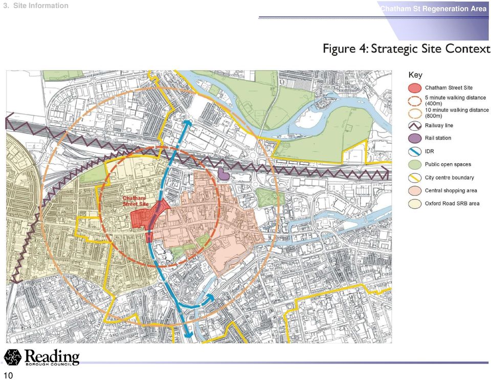
9 3. Site Information As shown in Figure 4, the site lies to the west of the core city centre area and includes part of the Inner Distribution Road (IDR), which is below street level at this point. The city centre, Civic Centre, Hexagon Theatre and Broad Street Mall are close by less than 5 minutes walk away, while the train station, river and the Oracle shopping centre are less than 10 minutes walk. The IDR physically separates the site from the town centre. Traffic leaving the IDR at Chatham Street is predominantly serving retail and commercial properties east of the junction, or seeking access to Oxford Road to head west. Crossings of the IDR are provided by two over-bridges at the Chatham Street junction and to the south along Oxford Road, allowing both traffic and pedestrian movements. Further junctions and crossings are provided both north and south of the site. To the east side of the IDR, the built frontage comprises offices, new housing development and a hotel. site by busy roads. The Oxford Road, in particular, is a barrier separating the site from the neighbouring residential areas to the south. The residential communities to the south and west of the site are relatively disadvantaged. They suffer from levels of social exclusion which are greater than the Reading average. The housing stock largely falls within a Conservation Area, with several listed buildings present along Oxford Road. There is a higher proportion of private rented accommodation in this area than the Reading average. Chatham Street forms the northern boundary of the regeneration site. As a dual carriageway, this too is a major barrier to pedestrian movement, with unattractive street frontages. Land uses north of Chatham Street are mixed and further separated from the site by a significant change in level. Chatham Street Land to the north, west and south of the site is predominantly terraced, two storey residential development, severed from the 9

10 3. Site Information 10
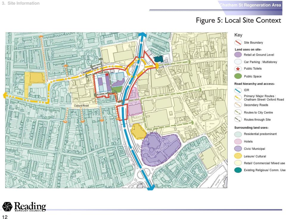
11 3. Site Information 3.3 Site Description and Current Uses The Chatham Street site is 2.5 hectares and is predominantly flat. The existing multistorey car park was built in the 1960s and is of predominantly concrete construction and 5/6 storeys in height. It dominates the local urban landscape with visually intrusive access ramps from Chatham Street and Eaton Place. The public space created is degraded and planted with mainly plane trees. The public realm in and around the site edges is poor in quality and condition. Buildings enclose it and create a threatening public environment, owing to low levels of pedestrian footfall. The northern edge is particularly inhospitable for pedestrians, sandwiched between derelict car park buildings and the busy Chatham Street. Renaissance Hotel, contract parking and Reading Borough Council. The car park does not operate at its full capacity and it is particularly underused during evenings when the site s security and safety is questionable. Public toilets are also included in the multistorey car park. The basement of the car park was formerly a night-club, which closed in The central section of the site has some small scale retail uses in an arcade, including furniture shops and a pet shop. Other retail units and office premises along Oxford Road back onto the sites. Eaton Place marks the western boundary of the site. Surface car parking areas create a rather unattractive urban scene. Existing uses and those immediately adjacent to the site are indicated in Figure 5. Chatham Street The multi-storey car park dominates the site. The car parks have a total of 1,100 spaces, although only 800 public spaces are operational, of which approximately 85% are available to the public on a pay and display basis. The remaining 15% are used by the 11

12 3. Site Information 12
13 3. Site Information 3.4 Utilities and Services Preliminary investigations reveal that the site is well served by utilities and there are no identified deficiencies in terms of supply networks. NTL and Cable and Wireless have equipment close to the site, but neither of these providers currently serves the site. 3.5 Site History Historic Uses The car park site was a residential area with terraced houses and gardens at the time of the earliest Ordnance Survey maps (1879). A number of houses on the north-eastern part of the site were demolished prior to Between 1912 and the late 1960s there appear to have been few changes to the site. In the 1960s the houses were demolished and the current multi-storey car park, the dual carriageway and the roundabout were constructed. Ownership The Chatham Street site is within Reading Borough Council freehold ownership, except for one tenancy with 10 years to run and some car park spaces leased by a local doctor s surgery. The Council is in active discussions with the leaseholders to acquire their interests, and if necessary is fully committed to using CPO Powers to acquire a controlling interest in the whole regeneration area. There are also two electricity sub-station leases on the site, on which negotiation with the Electricity Utility Company will be required. Planning History The Chatham Street site has no extant unimplemented planning consents except for use as contractors compounds for the Friar Street streetscape improvement. Any future planning applications will be considered in the light of Structure Plan and Local Plan policies and this Supplementary Planning Guidance. 3.6 Site Constraints and Opportunities Development of the Chatham Street site must take full account of the factors that influence its form, extent and viability. Proposals should build upon existing site opportunities in a positive fashion. The main opportunities and constraints are identified on Figure 6 and include: the presence of the IDR; potential ground and water contamination; archaeology; and the impact of listed buildings and the conservation area; as well as important economic and physical regeneration opportunities. Chatham Street Car Park regeneration opportunity 13

14 3. Site Information 14

15 3. Site Information The IDR The IDR is currently a barrier which divides the town centre from the Chatham Street site, both physically and perceptually. It is a constant source of noise and pollution. The Council would like to see this barrier overcome and the nuisance it causes to the site mitigated. The IDR- A major barrier Decking over the IDR would successfully meet this challenge, together with the benefit of increasing the developable area of the site. The Council concedes that this would entail a significant additional construction cost and may be at the expense of the existing slip roads. The traffic flow implications of the loss of the slip road would be significant and will need to be adequately planned for. The Council considers that the benefits of decking over the IDR will be significant. It will be the responsibility of the developer, together with the Council s transport team, to ensure that those benefits can be delivered without compromising the transport strategy of the Chatham Street area and Reading as a whole. Proposals for the redevelopment of the site must address the impact on existing traffic flows and provide effective solutions for traffic flows in the area. Decking the IDR area also provides useable space between the existing town centre and the development site that allows for a distinct architectural and design style, which can help to achieve an individual sense of place. The space can also enable a dramatic change of scale across the divide, which would otherwise be difficult to accommodate. The space across the IDR prevents tall buildings crowding out their neighbours. Equally there are good opportunities to develop tall landmark buildings and/or other landmark features which will help give a distinctiveness to the scheme and the city centre as a whole. Ground Conditions Preliminary evaluation indicates that ground contamination on the Chatham Street site is not a significant constraint, but more detailed testing may be required. There are underground storage tanks associated with the former petrol filling station. Contamination from neighbouring sites is a relatively low risk to future development, and should not affect design or development layout. The presence of asbestos has also been confirmed at the Chatham Street car park. This places a need for additional procedures during the construction process. Appropriate measures must be put in place in accordance with current regulations to ensure the safety of people on and off site during demolition works. 15

16 3. Site Information Utilities Existing utilities networks and plant are unlikely to suit the layout of new development and alterations will be required. This creates a degree of freedom in how the Chatham Street site is configured, but care must be taken to minimise disruption caused by work on utilities to surrounding neighbourhoods and traffic flows in the vicinity of the site. The developer will be required to produce a plan of the proposal s impact on utilities and show how they will be managed. Archaeology The results of an initial desk based assessment indicate that there are few prehistoric finds in the general area and the site lies largely beyond the medieval town s extent, although just to the east of the site a chapel was founded in There is only limited evidence to suggest that archaeological deposits were present on the site, though this has not been proved by modern archaeological investigation. In line with current legislative and local planning guidance, a full desk based assessment is recommended and from this it is likely that field evaluation may be required to determine whether or not archaeological deposits are present within the site. Listed Buildings The site is surrounded by a number of listed buildings notably Greyfriars Church and properties on Oxford Road and Chatham Street. Planning policy seeks to ensure that the setting of listed buildings is preserved or enhanced by neighbouring development. Conservation Area The Russell Street/Castle Hill Conservation Area is situated to the south of Oxford Road adjacent to the Chatham Street site. Planning policy requires that views into and out of the conservation area are preserved and enhanced. As such, particular care must be taken over the design and layout of development along the Oxford Road frontage, but also the appearance of the roofline, as the conservation area is on higher ground overlooking the Chatham Street site. Presence of the listed buildings and conservation area highlight the importance of high quality urban design and landscape in the new development. By focusing vistas and routes into and through the site on the quality features of the surrounding areas, and drawing on local architectural themes, the new development can extend and enhance the most important aspects of its surrounding environment. Further information on development principles and design guidelines is provided in Section 5. Greyfriars Church adjacent to the site has Grade I listed status. It is situated on a busy, wide junction above the IDR. New development should enhance its setting. 16

17 4. Policy Context The determination of any planning application for the Chatham Street site must have regard to current planning and development legislation. The Development Plan for Reading comprises the Berkshire Structure Plan (adopted in 1995) and the Reading Borough Local Plan (adopted in 1998). These documents are both under review. The Local Plan and Structure Plan Review timetables suggest that final adoption of both Plans will be in Reading City 2020 Vision is a non-statutory document setting out the Council s vision. Work is also underway on an associated City Centre Framework and City Centre Strategy. 4.1 National and Regional Policy Higher level planning policy is guided by Planning Policy Guidance Notes and Regional Guidance. National policy of particular relevance to Chatham Street site is PPG1 General Policies and Principles (1997); PPG6 Retail Development and Town Centres (1998); PPG13 Transport (December 1999) and PPG3 Housing (March 2000) which endorse and promote the following principles: Urban regeneration and the re-use of previously developed land. The benefits of mixed use development. Integrating land-use planning and transport. Maximising urban opportunities. Sustainable town centres. Providing appropriate levels of affordable housing and creation of mixed communities. Higher development densities, particularly around transport modes. Providing multi-modal travel options. Maximising opportunities for travel by non-car modes. Reducing the use of the car by limiting parking provision. The Urban White Paper The Urban White Paper (DETR, 2000) sets out the Government s proposals to promote an urban renaissance. It highlights the importance of mixed use regeneration schemes based around high quality design, sustainable transport proposals, and the provision of effective local services. The importance of finding local solutions to local problems is also underlined. The Council recognises the relevance of these concepts to the Chatham Street proposals. RPG 9 Regional Planning Guidance for the South East RPG9 (adopted December 2000), sets out the regional planning context for Reading. Reading is within the Thames Valley sub-area, part of the Western Policy Area, where the focus should be to build on economic strength, ensure growth with minimum pressure on the limited labour 17

18 4. Policy Context supply and land resources, and relieve pressures on transport networks. Berkshire Structure Plan The current statutory Berkshire Structure Plan, which covers the period , was adopted in November 1995, with an alteration made in August Sustainability is a key issue behind the policy approach (OS1). This requires undertaking development where the need for travel is minimised and managing pressures on the land and transport networks. A new Structure Plan is currently being prepared to cover the period The Deposit Draft version was published for public consultation in March Whilst not yet a formally adopted document, this emerging policy is important in that it informs the strategic context for the future development of Chatham Street. Policy E1 of the Deposit Draft states that Reading city centre should be a principal location for major office development. Other relevant policies in the Deposit Draft state that:- Reading s communities will be sustainable, and have good access to a range of local facilities, services, housing and employment. Reading will continue to develop as a regional centre serving the wider Thames Valley. The city centre will be transformed by high-quality large-scale mixed-use development providing major expansion of employment, retail, leisure and housing in a highly accessible location. Future development in Reading city centre should complement the existing provision and be based around activities that reflect the trend towards leisure and retailing. Further pedestrianisation and environmental improvement will be sought. The area around the station and other sites on the fringe of the core, provide significant scope for mixed-use development with excellent sustainable design quality. Development should be in line with the principles of urban renaissance, and will help support the centre in the future. 4.2 Local Policy Reading Borough Local Plan The Reading Borough Local Plan was adopted in A review of the Local Plan is underway and an Issues Paper was produced for public consultation during The local plan does not include site specific proposals for the redevelopment of Chatham Street. However, it does state that the future of the car park and its surrounding area will be the subject of a thorough review in the course of which all interested parties will be consulted. A significant number of general policies will have a bearing on proposals for the site. As an unallocated site, development will be considered on its merits subject to these policies (see Appendix 1). Considerations will include impacts on the transport system, 18

19 4. Policy Context housing supply, physical and social infrastructure, as well as the quality of the design and appearance of the development. The Local Plan also contains allocations adjacent to the site, which could influence its redevelopment. These are: 1. An area of archaeological potential that abuts the eastern side of the IDR, to which the following policies apply: Mitigation of development impact needs to be secured before permission is granted e.g. works to investigate and record findings; Where appropriate, satisfactory preservation of remains is required. 2. Russell Street/Castle Hill Conservation Area adjoins the southern boundary of the site along Oxford Road. The redevelopment of the Chatham Street site will be considered in relation to its impact upon the environmental quality of this Conservation Area. 3. There are a number of listed buildings adjoining the site including Grade II buildings located in Chatham Street, fronting Oxford Road and Howard Street. The most important building, however, is the Grade I listed Greyfriars Church and Vicarage to the north east on Friar Street, (refer to Figure 6). This church is said to be the most complete surviving example of Franciscan architecture in England. The proposals must have regard to their impact upon the setting of these important historic buildings. A full list of listed buildings is included in Appendix 3. Reading Local Transport Plan ( ) The Local Transport Plan (LTP) for Reading ( ) reflects the Council s aim to develop a fully integrated transport network. The network would provide viable choice, sustainability, priorities for walking, cycling and public transport which supports travel to, from and around the city but also minimises journey length, and in partnership with other policies, reduces the need to travel. The transport strategy developed for Reading focuses on three main themes: Promoting the Alternatives; Managing Demand; and Network Management The five year targets for the LTP area are primarily focused on the reduction of unnecessary car travel to the city centre, particularly in peak hours, with a corresponding increase in public transport, cycling and walking. Through the achievement of these targets, it is envisaged that a more sustainable and integrated transport network can be implemented. 4.3 Non-Statutory Policies Reading City 2020 A Vision for the Future The Council has adopted a document entitled Reading City 2020 "A Vision of the Future", which sets out a vision for the creation of a city centre and a series of environmentally and socially sustainable 19

20 4. Policy Context communities. This document constitutes the most up to date policy context for the Chatham Street development. The consultation document was published in early It sets out the vision for business, culture, education and skills, sustainable communities and transport, as well as promoting development opportunities in the city centre, including Chatham Street. It identifies key principles that should be incorporated into development where appropriate. Of particular importance to future development at Chatham Street are the following: Business Visions: Competitiveness, community enterprise and economic success linked to cultural enterprise. Cultural Visions: New facilities and creating places that are attractive to all people. Sustainable Communities: Local facilities enabling reduced car use, more city homes, partnership planning of communities, opportunities to use a range of transport modes. Transport: Designed for easy movement. Creating a City: Breaking through the IDR barrier, widening the mix of uses in the city centre and developing areas with distinct character. Illustrative sketches in the 2020 document indicate a possible future vision for Chatham Street. They depict: high quality architecture and design that creates a new development area with its own identity and sense of place; decking over the IDR to provide public spaces and new development well connected to the existing centre; high rise, landmark buildings above the IDR slip road roundabouts; building heights graduating upwards from the western side of the site towards the IDR; and a wider mix of uses in the city centre. This initial vision has been developed further through a City Centre Framework analysis prepared by Llewellyn Davies which is to form part of the comprehensive strategy for the future city centre. The Vision has established a new urban development agenda for Reading that seeks to expand the city centre across the railway lines and the IDR. The new development areas are to be known for their high quality design and public realm, providing a fine grain mix of uses, fully integrated with an appropriate transport network. The Council sees Chatham Street as one of the major development opportunities which if planned comprehensively along with surrounding sites can give a new structure to the west side of the city. This Brief draws on the findings of the City 2020 Vision consultation. The majority of submissions supported the overall Vision. There was strong support for more green areas and decking over the IDR, providing better facilities for non-car based modes of transport, and mixing of residential and business functions. Priorities were good housing, reduced congestion, improved air 20

21 4. Policy Context quality, equality of access, and early public involvement. All of these are addressed in this development brief. Local Agenda 21 This development should take place within the context of Reading's Local Agenda 21. This sets out how to approach development in a sustainable manner and the process it should be taken through to meet relevant sustainability principles. Life Worth Living A Cultural Strategy for Reading This Strategy has been approved by the Council s Cabinet and will be published in September It is a Reading Borough Council corporate document that sets the context for cultural development in Reading over the next ten years. Objectives and actions are identified for a number of themes. Two actions relate specifically to Chatham Street. Under the theme of Social Inclusion, Action 4 proposes that the Council will engage with developers and planners in planning cultural facilities and provision at the centre of new regeneration proposals, including those for the Chatham Street and station area. The theme Regional, National and International Role, states at Action 3 that the Council will prioritise the replacement of the Central Pool within the Chatham Street development. There are many ways in which the Chatham Street development can help achieve the wider objectives and contribute to delivering the actions identified in this strategy. These have been reflected in the development guidelines and opportunities set out elsewhere in this brief. Oxford Road SRB Partnership The Single Regeneration Budget (SRB) partnership was established in 1995, with an overarching vision to ensure the viability and prosperity of the Oxford Road area through a comprehensive range of projects. The seven years of funding came to an end in March 2002, following notable achievements in training, community integration and enabling environmental improvements and new community facilities. The Chatham Street redevelopment should be undertaken in a manner that complements and builds on the measures put in place. In particular, consideration should be given to the following: Maximising local employment opportunities, having regard to the local Skills Register and local labour in construction scheme. Making use of the Training, Employment and Advice Shop (TEA Shop). Complementing the streetscape initiative that has made significant environmental and community safety improvements along Oxford Road to the west. The Chatham Street development is an opportunity to extend the principles of this approach in a way which benefits the creation of a new high quality urban quarter. Helping to deliver the wider benefits to the local community. In particular the availability of accommodation for voluntary groups is an increasingly critical issue. Dedicated, suitable 21
22 4. Policy Context provision to meet this need would make a major contribution to meeting local needs and ensuring that regeneration proposals address social exclusion. Community Strategy A Community Strategy is being prepared in conjunction with the recently formed Strategic Partnership. The strategy is intended to form an overarching approach to the delivery of services across all sectors of the community. The Community Strategy is based on seven themes developed from the Sustainable Communities Dialogue. These are: - Accessible Spaces - Healthy People - Inclusive Society - Learning Community - Quality Environment - Safe Places - Thriving Economy 22
23 5. Development Requirements This section outlines the key design and development principles that should guide future redevelopment of the Chatham Street site. These principles help establish a city centre structure for the development of building forms that meet the current needs of Reading, while retaining flexibility to accommodate future changes. The principles will help manage the design process to ensure that the Chatham Street project is seen to be at the forefront of best practice in sustainability and design. It is intended that the guidelines identify the site-specific requirements and targets for quality and sustainability to ensure a level of consistency without constraining the architects and designers freedom to express individual design visions. Site information, the policy context and results of public consultation to date have informed the guidelines. These principles can be achieved through the use of the following: Principal routes and street networks; Pedestrian priority and cycle routes; Landmarks and views; Building heights and density; Land use mix; Street level frontages and servicing; Plot size and relationship; Architecture: sustainable approach; and Public open space. Each of these contributes to delivering at least one of the key development principles which are summarised below and explained in more detail in the remainder of this section. 5.1 Key Development Principles The key development principles are listed in the box overleaf. These aim to reinforce the concept of urban renaissance, and underpin practical solutions to bring high quality design and a distinct character to this extension of the heart of Reading. These principles should influence decisions about development at Chatham Street. 23
24 5. Development Requirements Policy Context KEY DEVELOPMENT PRINCIPLES 1. Permeable and accessible part of the City Centre that is people rather than car orientated. A particular focus is overcoming the barrier of the IDR and establishing visual and physical links with surrounding areas. 2. Robust urban framework. The extension of the city centre should be built to last and successfully adapt to evolving social and economic environments. The urban layout, buildings, permeability, and accessibility all contribute to achieving this principle. 3. Mix of uses to enhance the city centre. The land uses must complement the existing city centre functions, incorporating a mix of uses including, but not necessarily limited to, residential, commercial, retail, cultural/leisure, car parking, community facilities and public open space. 4. Development that is sensitive to and integrated with the adjoining residential area. Physical and visual links, as well as land uses, open space, architecture, street frontages, massing and building heights should all connect the existing residential areas with this new mixed use city centre quarter. 5. Place of character and distinct identity. Development must deliver a distinctive and attractive new quarter that exudes its own character and sense of place while integrating with the surrounding areas. 6. Design excellence and innovation. Encourage high quality architecture and public realm, that is innovative and forward looking, at different scales that is based on a combination of nationally agreed standards and guidance and a careful interpretation of local needs. 7. Create a high quality public realm. It is important to set quality standards for the city centre. This should include public art and a mix of hard and soft landscaping that is integrated with existing open space and is inclusive and accessible to all. 8. Embracing principles of sustainability. Sustainability should underpin all aspects of the design and development process and include integration of land use and transportation. 9. Maintainable and manageable solutions. Development proposals must be accompanied by long term management proposals that ensure the quality and functionality of the area are not compromised over time. 10. Social inclusion. The development should demonstrate a positive contribution towards tackling social exclusion during the planning, construction and subsequent occupation. This will include creating local employment, offering a range of affordable housing options and facilitating sustainable community initiatives. 11. Creating local employment links. Opportunities to provide local employment during the development process and once buildings are occupied should be maximised. 12. Financially viable development. Sufficient critical mass of development is required to ensure that proposals are capable of completion without significant public sector funding. 13. Partnership Approach. Design, development and delivery should be in consultation with the local authority and local stakeholders. 24
25 5. Development Requirements 5.2 Permeability and Accessibility Principal Routes and Street Network Development proposals for Chatham Street Regeneration Area should respond to the existing street pattern and enhance connections and potential future connections between the city centre, adjoining residential and commercial areas and future development in neighbouring areas. The scheme should address physical and visual links and work to reinforce or establish the relationship with the surrounding area with the over-riding objective to improve permeability through, and into, the site. Figure 7 shows the desired permeability and accessibility framework that should guide development proposals. Pedestrians must be given priority over vehicular traffic in the new framework of streets and spaces, where all types of people are comfortable and which are safe and welcoming. The new development should have a significant presence on Oxford Road to signal the gateway into the site and the city centre. From this clear entry point, the primary pedestrian movement corridors should be legible and draw people towards the heart of the new development and a new City Square providing high quality public space (refer to Figure 8). Development proposals should identify significant improvements to Thorn Street, Eaton Place and Alfred Street as entrances to the site and also as links to Queens Walk and the Civic Centre, Friar Street, Cheapside and the north side of Chatham Street. The new development should maximise the opportunities offered by its proximity to Reading Station, particularly given proposals for a new transport interchange and a redevelopment of this area. Excellent pedestrian connections from Chatham Street through to the station area will be of fundamental importance. Public Transport Accessibility Proximity to the city centre and Reading Station gives the Chatham Street site excellent local, regional and national public Policy Context transport accessibility by both rail and bus. Good local links into these public transport networks will encourage their use for access to the site. Integration through good pedestrian links to the city centre and station area will help. Consideration will also have to be given as to how local buses directly serve the site. The Oxford Road is a very important and busy bus corridor, which will directly serve the site. The priority given to public transport in the city centre will need to be reflected in any gateways to the site. Overcoming the IDR Barrier The IDR, whilst having an important function for local and through traffic, is a major barrier between new development on Chatham Street and the existing city centre. The principle of decking over the IDR was put forward during the consultation on the Reading City 2020 Vision. This is an essential element of a successful scheme at Chatham Street, without which the site cannot be integrated with the existing city centre. 25
26 5. Development Requirements The development of the Chatham Street site will inevitably change the use of the surrounding road network. The decking could require the slip roads to the south to be closed. It will reduce the barrier effect, both on the approach along Oxford Road and in the north western corner of the site. The developer will be required to demonstrate an understanding of the likely changes and agree with the Council a plan to mitigate and manage those changes. give significantly greater priority to pedestrians and cyclists within the Chatham Street site. Policy Context level of passive surveillance and street activity outside working hours will be encouraged. Decking will deliver a significant amount of additional land for either development or provision of public open space. Development on the deck will be constrained by limitations on foundation depths and the weight capacity of the structure, but where possible, it is important that the highly visible locations are used to maximum benefit as landmarks and to advertise the quality of development elsewhere in the Chatham Street Regeneration Area. Pedestrian and Cycle Movement As part of the integrated movement strategy and to enhance the principal routes identified above, development proposals will need to Tree lined boulevard to create pedestrian friendly routes into and through the site Detailed consideration should be give to safety and security measures including CCTV, lighting and sign-posting encouraging effective movement throughout the development itself and the wider city centre during the day and night. Development mixes including residential, along with restaurants, bars and cafes that enhance the Activity that is associated with vibrant ground floor uses Pedestrian priority and public realm treatment will focus around the new City Square, Oxford Road, and the connections to Broad Street, Friar Street and the Reading Station Interchange area. Pedestrian movement in these areas will be encouraged through: active ground floor uses that provide activity through the day into the evening; a mix of uses which provide activity at different times during the day; 26
27 5. Development Requirements public art; lighting for aesthetic and safety purposes; Cycle parking street furniture designed for the purpose it is intended Pedestrian friendly environment Policy Context responsive landscaping; at grade crossing of roads with pedestrian priority; and uncluttered streetscape. The new development should provide enhanced cycle parking as part of the public realm and within each of the new buildings, include secure parking areas and lockers for cyclists. These measures to encourage pedestrians and cyclists are an important step towards integrating development with transport. Enabling non-car access to the scheme, helps to deliver core sustainability objectives. Public realm that encourages a range of after work activities Space for people 27
28 5. Development Requirements Policy Context 28
29 5. Development Requirements 5.3 A Robust Urban Framework Plot Size and Relationship Although influenced by its location and preferred land use, the plot sizes and the majority of building forms should be simple and robust rather than rigidly designed to a particular end user. This will allow flexibility to accommodate future uses. The masterplan should include a range of plot sizes. At the upper scale, they should be large enough to accommodate current commercial office requirements (approximately 2,000m² floor plate) without restricting a possible change of use. The remainder of the plots should be designed to accommodate a mix of residential property types and smaller office floor plates (approximately 1,000 net square metres). General Principles for Buildings morphology that promotes robust commercial and residential buildings should be established. In addition, building types should positively address the following design issues: orientation and design to increase daylight provision in offices; orientation to maximise solar gain and sky exposure; utilise opportunities for natural ventilation; ensure all new commercial premises attain a BREEM rating of very good as a minimum and excellent as the objective; including energy use and renewable energy use, low water use, avoidance of pollution, safeguarding health and the use of materials; Policy Context introduce pressurisation testing on new building types to limit heat loss; where possible use recycled materials; The inclusion of technologies and design approaches should be reviewed over time as some innovative practice becomes best practice and experimental technologies are tried and tested. Figure 8 identifies the urban grain, frontages and landmarks that should be adhered to when planning development in the Chatham Street Regeneration Area. This design framework identifies a number of high-level priorities for new development in Chatham Street including promotion of sustainable scale and form. In particular a ensure all new dwellings attain an EcoHomes rating of very good, and an National Home Energy Rating of 10; 29
30 5. Development Requirements Policy Context 30
31 5. Development Requirements Policy Context 5.4 Land Use Mix Mixed Use Development Development proposals should include a balanced mix of land uses. Land uses must reflect levels of accessibility: close to the city centre and with already congested roads it is not suitable for development that is predominantly served by cars or requires heavy flows of goods vehicles. The size of the site and its proximity at the western edge of the town centre, offer an opportunity to devise a major mixed use scheme. Suitable uses include a mix of offices, hotels, residential (including affordable housing), retail, leisure and community uses. The proposal should provide public parking spaces to serve the centre as a whole, with a preference for short stay spaces (for the use of shoppers, for example), rather than long stay spaces for commuters. The mix of uses incorporated should aim to: establish a new commercial hub and residential community, while enhancing the mix of uses in the city centre. complement each other as well as land uses off site, thereby strengthening the area as a whole. deliver activity and vibrancy and animate key public spaces. help provide natural surveillance over public areas, boosting the sense of safety for users of the scheme. Land Use Layout The detailed siting of these uses is not fixed by this Brief allowing sufficient flexibility for proposals to respond to changing market conditions. However, it is important that a strategic logic, based on urban analysis and best practice, is adopted. The urban design analysis suggests a logical approach to the allocation of land uses, as described below and illustrated in Figure 10. The west of the site is predominantly residential consisting of terrace houses built on a traditional street pattern. The re-connection to this urban grid and residential land use reflects the Council s vision for the City Centre and is essential to the success of the Chatham Street Regeneration Area and therefore the development should reflect this priority. The western edge of the site should be predominantly residential in character with a mix of housing types, sizes, and affordability levels to attract a range of occupiers, reflecting the need to sensitively integrate the development with the local residential area. From the west, the IDR has traditionally been seen as the boundary of the city centre and the edge of retail development. The Chatham Street development is intended to blur this distinction and create continuity in line with the Council s vision for the City Centre. Therefore, the eastern half of the site, surrounding the City Square, should be a best practice example of vertical and horizontal mix of uses, ensuring a hour vibrant community. The ground floor uses should be active retail areas with a focus on restaurants, cafes, and bars. 31
Alternatives and Design Evolution: Planning Application 1 - RBKC
 3 Alternatives and Design Evolution: Planning Application 1 - RBKC Design Freeze Draft One (January 2011) Figure 3-19 3.82 The design freeze draft one was a point in time in the evolution of the Masterplan
05 AREA/SITE SPECIFIC GUIDELINES
 05 AREA/SITE SPECIFIC GUIDELINES Site 1 - Glass Yard The leisure centre that is currently located on this site should move to a more central location in the town centre close to the existing public squares.
Welcome & background. www.theperfumefactory.info
 Welcome & background Essential Living welcomes you to this community involvement event introducing the proposed redevelopment of The Perfume Factory, North Acton. EXISTING SITE PLAN AERIAL VIEW OF SITE
WELCOME PROPOSALS FOR PENTAVIA RETAIL PARK WELCOME TO OUR EXHIBITION WHICH SETS OUT OUR PLANS TO DEVELOP THE PENTAVIA RETAIL PARK SITE.
 WELCOME WELCOME TO OUR EXHIBITION WHICH SETS OUT OUR PLANS TO DEVELOP THE PENTAVIA RETAIL PARK SITE. The purpose of the exhibition is to provide the community with the opportunity to view our initial ideas
WELCOME TO OUR EXHIBITION
 WELCOME TO OUR EXHIBITION The purpose of the exhibition is to provide you with the opportunity to view our proposals and give feedback prior to the submission of a planning application to the London Borough
OVERARCHING SPATIAL POLICIES
 3 OVERARCHING SPATIAL POLICIES 29 Overarching Spatial Policies 3.1 This chapter contains policies addressing the following policy themes: OSP 1: Optimising growth OSP 2: Land use OSP 3: Connections and
DEVELOPMENT BRIEF FOR LAND AT ALLOA ROAD, TULLIBODY
 DEVELOPMENT BRIEF FOR LAND AT ALLOA ROAD, TULLIBODY 1.0 Introduction and Purpose 1.1 Clackmannanshire Council is seeking to dispose of a site at Alloa Road, Tullibody for redevelopment. The site extends
Gold Property Developments welcomes you to this exhibition of the draft plans for the regeneration of the Holborn Studios site on Eagle Wharf Road.
 WELCOME Gold Property Developments welcomes you to this exhibition of the draft plans for the regeneration of the Holborn Studios site on Eagle Wharf Road. The site covers approximately 0.37 hectares and
On the instruction of Ros Goode & Roland Morgan, Joint Fixed Charge Receivers
 FOR SALE On the instruction of Ros Goode & Roland Morgan, Joint Fixed Charge Receivers Land at Teville Gate, Teville Road, Worthing, West Sussex BN11 1AZ ibrochure - www.cbre-ibrochure.co.uk/worthing ENTER
FLOOD RISK STATEMENT IN SUPPORT OF THE CONNECTING HERNE BAY AREA ACTION PLAN PREFERRED OPTIONS DOCUMENT
 FLOOD RISK STATEMENT IN SUPPORT OF THE CONNECTING HERNE BAY AREA ACTION PLAN PREFERRED OPTIONS DOCUMENT Canterbury City Council January 2008 1 APPLICATION OF THE PPS25 SEQUENTIAL AND EXCEPTION TESTS 1.0
Richmond upon Thames College. Draft Planning Brief. May 2008
 Richmond upon Thames College Draft Planning Brief May 2008 1. Introduction 1.1 The purpose of this Planning Brief is to establish a development framework for the proposed comprehensive redevelopment of
A new Garden Neighbourhood for West Guildford An opportunity for Smart Growth. university of surrey November 2013
 A new Garden Neighbourhood for West Guildford An opportunity for Smart Growth university of surrey November 2013 A new Garden Neighbourhood for West Guildford Preface Since the County and Borough Councils
urban living and contributes positively to the character of
 chapter six objective four Recognise the varied character of Hounslow s districts and seek to protect and improve their special qualities, heritage assets and overall townscape quality and appearance.
www.thefurlongphase2.co.uk
 Welcome Thank you for coming along today to view our plans for Phase 2 of The Furlong Shopping Centre. We are undertaking a consultation programme that will run up to and beyond submission of the planning
Glossop Design & Place Making Strategy
 Supplementary Planning Document to the High Peak Local Plan June 2011 Design Brief for the Town Hall Complex GILLESPIES I GERALD EVE Reproduced from the Ordnance Survey map with the permission of Ordnance
New Waterloo. Transforming the Elizabeth House site
 New Waterloo Transforming the Elizabeth House site 02 Transforming Elizabeth House 03 Transforming Elizabeth House Transforming Elizabeth House This booklet has been produced by Chelsfield and London &
City Plan Part 1 Sustainability Appraisal Summary February 2012
 City Plan Part 1 Sustainability Appraisal Summary February 2012 1.0 Introduction The Council is in the process of preparing its new Local Plan in consultation with the public, developers, landowners and
Report to Planning applications committee Item Date 6 March 2014 Head of planning services
 Report to Planning applications committee Item Date 6 March 2014 Report of Head of planning services 4(7) Subject 13/02051/F Former Wellesley First School Wellesley Avenue North Norwich NR1 4NT Description:
Key Facts. Passenger growth at the airport is projected to grow to approximately 3 million passengers per annum by 2030.
 Bournemouth Airport & Business Park 7 7 Bournemouth Airport & Business Park Introduction 7.1 Bournemouth Airport is a key asset for the region, one of the UK s fastest growing regional airports and is
Major and Minor Schemes
 1 Major and Minor Schemes Peterborough City Council has identified a number of proposals for major transport schemes over the next five year period that will support the planned housing and employment
HurlinghamRetailPark. Aerial view of site. Welcome to our exhibition of proposals for the redevelopment of the Hurlingham Retail Park.
 HurlinghamRetailPark Aerial view of site Welcome Welcome to our exhibition of proposals for the redevelopment of the Hurlingham Retail Park. Londonewcastle, a specialist residential developer, has been
VISION, DESIGN PRINCIPLES & OVERALL PLANNING STRATEGY
 3 VISION, DESIGN PRINCIPLES & OVERALL PLANNING STRATEGY The overall planning strategy for the Bank Street CDP is to ensure that future development is undertaken in a coordinated and planned approach, supported
Manchester City Council Planning and Highways Committee 2 June 2011
 Application Number 095804/FO/2011/N1 Date of Appln 21st Mar 2011 Committee Date 2nd Jun 2011 Ward Cheetham Ward Proposal Location Applicant Agent Installation of 929 square metre mezzanine floor area to
Site Deliverability Statement Alternative Site at: Bridge Road, Old St Mellons
 Site Deliverability Statement Alternative Site at: Bridge Road, Old St Mellons Representor Number 1135 AS(N)4 Persimmon Homes 9 th February 2015 Contents Site Deliverability Statement Alternative Site
FIRST STREET NORTH CREATING PLACES FOR PEOPLE
 About This Consultation Manchester City Council and Ask Property Developments are seeking to develop First Street North, a 2.2 acre site to the north of the Number One Building, within the 20 acre First
Draft New Museums Site Development Framework Supplementary Planning Document SUSTAINABILITY APPRAISAL SCREENING REPORT
 Draft New Museums Site Development Framework Supplementary Planning Document SUSTAINABILITY APPRAISAL SCREENING REPORT MAY 2015 1 Contents 1 INTRODUCTION 3 2 DRAFT NEW MUSEUMS SITE SPD 4 3 STRATEGIC ENVIRONMENTAL
WELCOME WELCOME TO THE PUBLIC EXHIBITION FOR THE ILONA ROSE HOUSE REDEVELOPMENT. ILONA ROSE HOUSE www.ilonarosehouse.com
 WELCOME Manette Street from Charing Cross Road WELCOME TO THE PUBLIC EXHIBITION FOR THE REDEVELOPMENT. Corner of Charing Cross Road and Manette Street SOHO ESTATES Soho Estates began as a collection of
Planning should achieve high quality urban design and architecture that: Contributes positively to local urban character and sense of place.
 15 BUILT ENVIRONMENT AND HERITAGE 15/07/2013 VC100 Planning should ensure all new land use and development appropriately responds to its landscape, valued built form and cultural context, and protect places
Relevant Planning History P/2006/1070: Demolition of building and construction of supermarket and 14 2 bed flats. Withdrawn.
 P/2010/1404/MPA St Marychurch Ward Former G A Insurance Buildng, Greenway Road/St Marychurch Road, St Marychurch Torquay Demolition of former G A building; formation of up to 7 retail units for purposes
Erection of replacement warehouse building and erection of two buildings in connection with builder s merchants
 Plan: O 02/00708/FUL Thames Ward (A) Address: Development: Applicant: London Works, Ripple Road, Barking Erection of replacement warehouse building and erection of two buildings in connection with builder
Perth and Kinross Council Development Control Committee 18 March 2009 Recommendation by Development Quality Manager
 Perth and Kinross Council Development Control Committee 18 March 2009 Recommendation by Development Quality Manager 4(9) 09/161 Alteration and Extension to Existing Public House to Provide a New Bookmakers
Site Deliverability Statement Development at: Beech Lane, Kislingbury. Persimmon Homes Midlands March 2015
 Site Deliverability Statement Development at: Beech Lane, Kislingbury Persimmon Homes Midlands March 2015 Contents Site Deliverability Statement Development at: Beech Lane, Kislingbury 1.INTRODUCTION 1.1
21.04 LAND USE. Managing amenity through land use strategies
 21.04 LAND USE This section contains objectives and strategies for land use, under the themes of: Housing and community Retail, entertainment and the arts Office and commercial use Industry Education and
3.0 Planning Policies
 3.0 Planning Policies 3.1 National Policy 3.1.1 Government Planning Policy Guidance Notes (PPGs), and Planning Policy Statements (PPSs) provide the background to most aspects of the planning system. The
"Description of the urban and architectural development conceptual design of the historical city centre of Gorzow Wlkp. R3DC4T
 "Description of the urban and architectural development conceptual design of the historical city centre of Gorzow Wlkp. R3DC4T Gorzów Wielkopolski Gorzów Wielkopolski is an important regional city centre
READING PHOEN. NEWLY REFURBISHED HQ OFFICE AVAILABLE FROM 4,000 52,000 sq ft
 PHOENIX READING PHOENIX PHOEN NEWLY REFURBISHED HQ OFFICE AVAILABLE FROM 4,000 52,000 sq ft TO LET REFURBISHED AIR CONDITIONED OFFICES 4,000 to 52,000 sq ft 52 CAR SPACES ADJACENT TO READING RAIL STATION
Report To: The Planning Board Date: 2 April 2014. Report By: Head of Regeneration and Planning Report No: 14/0023/IC
 Agenda Item No. 2 Report To: The Planning Board Date: 2 April 2014 Report By: Head of Regeneration and Planning Report No: 14/0023/IC Local Application Development Contact Officer: Subject: Michael Martin
Cycle Network Modelling A new evidence-based approach to the creation of cycling strategy
 Cycle Network Modelling A new evidence-based approach to the creation of cycling strategy A The Business Cycle, London, mapping of commuter cycle routes and hotspots, 2000. A It is refreshing to see an
Welcome to our exhibition
 Welcome to our exhibition Welcome to this public exhibition for Cherry Park, Westfield, Stratford. This exhibition has been organised to update residents on Cherry Park, the next phase of development in
21 Plumbers Row, London, E1 1EQ
 Committee: Development Date: 19 th October 2011 Classification: Unrestricted Agenda Item No: Report of: Corporate Director of Development and Renewal Case Officer: Shahara Ali-Hempstead Title: Planning
Mount Browne (Surrey Police Head Quarters), Sandy Lane, Guildford Vision Statement. November 2013. with
, Sandy Lane, Guildford Vision Statement. November 2013. with") Mount Browne (Surrey Police Head Quarters), Sandy Lane, Guildford Vision Statement November 2013 with Tibbalds Planning & Urban Design 19 Maltings Place 169 Tower Bridge Road London SE1 3JB Telephone 020
Mount Browne (Surrey Police Head Quarters), Sandy Lane, Guildford Vision Statement November 2013 with Tibbalds Planning & Urban Design 19 Maltings Place 169 Tower Bridge Road London SE1 3JB Telephone 020
6 Streetscape character 6.1
 6 6.1 6 Streetscape character Introduction Transport interchanges The TLRN is the strategic road network for London and varies in character across the capital. The variation of the land use across London
Shannon Corner Service Centre, 208-212 Burlington Road, New Malden, KT3 4NP
 Shannon Corner Service Centre, 08-1 Burlington Road, New Malden, KT NP S1 Total site area (ha) 0.05ha Current MOT Car Repair Undeveloped land (ha) 0 Number of units 1 Grid reference TQ 680 Sequential status
SCHEDULE 16 TO THE SPECIAL USE ZONE. Shown on the planning scheme map as SUZ16. BALLARAT RAILWAY STATION PRECINCT. Purpose
 SCHEDULE 16 TO THE SPECIAL USE ZONE Shown on the planning scheme map as SUZ16. BALLARAT RAILWAY STATION PRECINCT Purpose To facilitate the revitalisation of the Ballarat Station Precinct in accordance
4 Alternatives and Design Evolution
 4 Introduction 4.1 This Chapter describes the considerations and constraints influencing the siting, layout and massing of the Development. It also describes the main alternatives to the Development that
PROPOSED PLANNING SCHEME AMENDMENT FOR FORMER CARLTON AND UNITED BREWERIES SITE, CARLTON
 Page 1 of 57 PLANNING COMMITTEE REPORT Agenda Item 5.4 PROPOSED PLANNING SCHEME AMENDMENT FOR FORMER CARLTON AND UNITED BREWERIES SITE, CARLTON 4 September 2007 Division Sustainability and Regulatory Services
Kings Road, Beith. Development Brief. Part 1: Site Specific Information
 Kings Road, Beith Development Brief Part : Site Specific Information Introduction Kings Road is a greenfield site on the north west edge of Beith and is currently let for grazing. The site is roughly rectangular
Advice can also be sought from specific specialist officers in the Council.
 Canterbury City Council Validation of Planning Applications Guidance note 2010: Introduction Up to date advice on the validation of planning applications is contained in the CLG Guidance on information
Department of State Development, Infrastructure and Planning. State Planning Policy state interest guideline. State transport infrastructure
 Department of State Development, Infrastructure and Planning State Planning Policy state interest guideline State transport infrastructure July 2014 Great state. Great opportunity. Preface Using this state
Guildford Station Regeneration
 Welcome Thank you for taking the time to view our proposals for the redevelopment of Guildford station. We have now submitted a planning application and would like to hear what you think of our plans.
The land is allocated within the Westbury on Trym Conservation Area and the land is protected by a blanket TPO 340.
 SITE DESCRIPTION The site is occupied by a large single dwelling house which was built in 2007. The building is surrounded by large trees and has a substantial rear garden. The land is allocated within
RE: CONSULTATION ON THE DEVELOPMENT MANAGEMENT AND THE SITE ALLOCATIONS DPD CONSULTATION DOCUMENT REPRESENTATIONS MADE ON BEHALF OF SAFESTORE.
 23 March 2015 Haringey Planning Policy River Park House 225 High Road London N22 8HQ Dear Sir RE: CONSULTATION ON THE DEVELOPMENT MANAGEMENT AND THE SITE ALLOCATIONS DPD CONSULTATION DOCUMENT REPRESENTATIONS
Appendix B. Revised Town Centre Development Strategy
 Appendix B Revised Town Centre Development Strategy June 2004 1 THE FUTURE OF HARROW TOWN CENTRE Harrow Town Centre has many good features and is rightly considered a major and important London centre.
74 Rivington Street. Planning Statement JULY 2013 DP9. 100 Pall Mall. London SW1Y 5NQ. Tel: 020 7004 1700. Fax: 020 7004 1790
 74 Rivington Street Planning Statement JULY 2013 DP9 100 Pall Mall London SW1Y 5NQ Tel: 020 7004 1700 Fax: 020 7004 1790 CONTENTS Page 1.0 Introduction 1 2.0 Site Description 2 3.0 The Proposed Development
Development Layout Design
 Development Layout Design General Design Considerations for Adoptable Highways Version 1 June 2012 Transportation, Waste and Environment Service Issue and Revisions Record Revision Date Originator Purpose
Ward: Purley DELEGATED BUSINESS MEETING Lead Officer: Head of Planning Control week of 23/03/2009
 Ward: Purley DELEGATED BUSINESS MEETING Lead Officer: Head of Planning Control week of 23/03/2009 Application No. 09/00389/LP - 51-61 Whytecliffe Road South, Purley, CR8 1. SUMMARY 1.1 This report concerns
Camden Development Policies
 Camden Local Development Framework Camden Development Policies Adoption version 2010 1 CAMDEN LOCAL DEVELOPMENT FRAMEWORK CAMDEN DEVELOPMENT POLICIES Camden Development Policies 2010 Introduction 1. Location
Guidance on Householder permitted development rights
 FORWARD CONTENTS CLOSE Guidance on Householder permitted development rights Circular 1/2012 CONTENTS BACK FORWARD CLOSE 1. INTRODUCTION 04 2. BEFORE STARTING 05 3. MAIN CONCEPTS 07 Principal elevation
TRANSPORT ASSESSMENT GUIDANCE
 TRANSPORT ASSESSMENT GUIDANCE Contents 1 INTRODUCTION...1 Purpose of the Guidance...1 Policy Context...1 Who Should Read This Document?...2 Structure of Guidance...3 2 ASSESSMENT PRINCIPLES AND PROCESS...4
Development Brief for New Lodge, Bank Mill Lane Berkhamsted. Adopted November 2007
 Development Brief for New Lodge, Bank Mill Lane Berkhamsted Adopted November 2007 This publication seeks your opinions about the design, layout and requirements for new housing development at New Lodge,
KINGSTON TOWN PLANNING SUB-COMMITTEE 23 MARCH 2005. YELLOW BOX STORAGE 163-165, LONDON ROAD AND 50, GORDON ROAD, Application Number: 05/12156
 APPENDIX C KINGSTON TOWN PLANNING SUB-COMMITTEE 23 MARCH 2005 YELLOW BOX STORAGE 163-165, LONDON ROAD AND 50, GORDON ROAD, Application Number: 05/12156 REPORT BY HEAD OF PLANNING AND DEVELOPMENT SUMMARY
28.0 Development Permit Area #2 (Neighbourhood District)
") 28.0 Development Permit Area #2 (Neighbourhood District) Goals and Objectives To provide a guide for infill and new development in the Neighbourhood District. To outline the nature, form and character
28.0 Development Permit Area #2 (Neighbourhood District) Goals and Objectives To provide a guide for infill and new development in the Neighbourhood District. To outline the nature, form and character
A Vision for the future of Ascot, Sunninghill and Sunningdale
 Have your say on future planning decisions in Ascot, Sunninghill and Sunningdale Our local Neighbourhood Plan tell us what you think... This is an exciting opportunity for you to have a say about how our
WELCOME. www.firstbase-haslemere.london
 Aerial view of the existing site Welcome to the second public exhibition on our ideas for the future of the Haslemere Industrial Estate. We held our first public exhibition in June where we set out our
Supplementary Planning Document. Radlett. District Centre Key Locations. Planning brief. March 2011. Hertsmere Borough Council
 Supplementary Planning Document Radlett District Centre Key Locations Planning brief March 2011 Hertsmere Borough Council Large print and languages Hertsmere Borough Council aims to provide information
Development proposals will require to demonstrate, according to scale, type and location, that they:-
 Appendix 2 : Relevant Development Plan Policies Angus Local Plan Review 2009 Policy S1 : Development Boundaries (a) Within development boundaries proposals for new development on sites not allocated on
K M D Hire Services, LONDON ROAD, NANTWICH, CW5 6LU
 Application No: 11/2196N Location: Proposal: Applicant: Expiry Date: K M D Hire Services, LONDON ROAD, NANTWICH, CW5 6LU Extension and New Store Mr Dan Mellor 17-Aug-2011 SUMMARY RECOMMENDATION Approve
LEWES DISTRICT AND SOUTH DOWNS NATIONAL PARK AUTHORITY LEWES DISTRICT JOINT CORE STRATEGY INDEPENDENT EXAMINATION
 1 LEWES DISTRICT AND SOUTH DOWNS NATIONAL PARK AUTHORITY LEWES DISTRICT JOINT CORE STRATEGY INDEPENDENT EXAMINATION STATEMENT BY CROUDACE STRATEGIC LIMITED ISSUES 7 AND 8 STRATEGIC SITES (POLICIES SP5/SP6)
8 DELIVERING THE MOVEMENT FRAMEWORK
 8 DELIVERING THE MOVEMENT FRAMEWORK Introduction 8.1 The purpose of this section of the design code is to orchestrate the delivery of essential road infrastructure highlighted in the masterplan and movement
Officer Update Report. Section 1 Site Location Map
 Officer Update Report Section 1 Site Location Map 1 Section 2 Application Summary Location Ward Proposal Application Applicant Agent 137 Stamford Street, London SE1 9NN Bishop s Retrospective change of
Public Consultation Series - The Strategic and Cost Planning Process in Dublin
 Consultation Summary DOCUMENT CONTROL SHEET Client Project Title Document Title Document No. This Document Comprises National Transport Authority 2030 Vision Consultation Summary MDE0758RP0012 DCS TOC
Sector Design Concepts
 Section C Sector Design Concepts C7 Sector 7 Great North Road Underpass 6 6 6 C7. Existing situation Sector 7 refers to the cut and cover section of the project linking the northern end of the deep tunnels
www.bolton.gov.uk/merchantsquarter Shaping the Future of Bolton
 Merchant s Masterplan: Supplementary Planning Document www.bolton.gov.uk/merchantsquarter Shaping the Future of Bolton Summary This document is a Supplementary Planning Document (SPD). It provides further
Construction of a pedestrian footbridge between Chiswick Business Park and Bollo Lane/Colonial Drive.
 planning report D&P/2857b/01 30 November 2015 Bollo Lane, Chiswick Business Park and Colonial Drive, Chiswick in the London Borough of Ealing planning application no. PP/2015/5442 Strategic planning application
Former Gala Bingo Kingston TOWNSCAPE STUDY AND SUPPORTING DESIGN + ACCESS STATEMENT January 2014
 Former Gala Bingo Kingston TOWNSCAPE STUDY AND SUPPORTING DESIGN + ACCESS STATEMENT January 2014 November 2013 Conran & Partners 22 Shad Thames London SE1 2YU 1st Floor Hanover House 118 Queens Road Brighton
Coventry Development Plan 2016 Appendix 89. Glossary of Key Terms
 Coventry Development Plan 2016 Appendix 89 Glossary of Key Terms Area Action Plan A Development Plan Document which focuses upon a specific location or an area subject to significant change. Affordable
LONDON BOROUGH OF HAVERING
 LONDON BOROUGH OF HAVERING CORPORATE ASSET MANAGEMENT PLAN 2015-2019 Sections LONDON BOROUGH OF HAVERING CORPORATE ASSET MANAGEMENT PLAN CONTENTS 1 Introduction and Context 2 Corporate Vision 3 Policy
Area 5: Emma Place/Millbay Road.
 Area 5: Emma Place/Millbay Road. Emma Place This area was one of the first to have been built as part of the early residential development of Stonehouse, and while these terraces are only a fragment of
LONDON ROAD SEVENOAKS
 WELCOME TO THE BERKELEY HOMES EXHIBITION Train Station Gr anv i ll e Dar tford Road Lo ad Ro nd on ad Ro Eard SITE Th ed riv e ley R oad on R oad A 224 Gord Pem b rok e Roa d Site Location Since the submission
Bedford s Network Management Strategy (2011 2021) November 2010
 November 2010") Bedford s Network Management Strategy (2011 2021) November 2010 Page 1 of 13 1. Introduction 1.1. The Bedford Borough Council Network Management Strategy has been developed to support local and national
Bedford s Network Management Strategy (2011 2021) November 2010 Page 1 of 13 1. Introduction 1.1. The Bedford Borough Council Network Management Strategy has been developed to support local and national
ACHIEVING GOOD URBAN DESIGN - RAINBOW ESTATE
 ACHIEVING GOOD URBAN DESIGN - RAINBOW ESTATE 1.1 The National Planning Policy Framework sets out what good design should aim to achieve, in a set of six statements that are complementary to policies contained
Transport Mobility Management: Small Changes - Big Impacts
 Transport Mobility Management: Small Changes - Big Impacts Understanding TMM in the Urban Context Damian PRICE and Amy LEATHER Abstract Although Transport Mobility Management (TMM) is still considered
LANDSCAPE AND DEVELOPMENT CHECKLIST FOR MONMOUTHSHIRE COUNTY COUNCIL
 LANDSCAPE AND DEVELOPMENT CHECKLIST FOR MONMOUTHSHIRE COUNTY COUNCIL 1 Introduction It is to the advantage of the developer to treat the environmental aspects of development proposals seriously and take
How To Develop The Kingsgate Business Centre
 Kingsgate Business Centre Employment Report Introduction The subject property comprises serviced offices arranged over two floors within a building in the north side of Kingsgate Road. It is served by
Design Guidance for Perimeter Fencing at Schools for Nottinghamshire County Council
 APPENDIX 1 Design Guidance for Perimeter Fencing at Schools for Nottinghamshire County Council Introduction: The purpose of this guide is to set out some parameters for assessing planning applications
Demand for Long Distance Travel
 Demand for Long Distance Travel April 2011 Demand for long distance travel 1 Structure of this paper 1.1 This paper is structured as follows: Section 2 sets out past trends in the demand for long distance
DELIVERY & SERVICING PLAN. REDWOOD PARTNERSHIP Consulting Engineers Transportation Planners
 Redwood Partnership Transportation Limited Maritime House Basin Road North Portslade Brighton BN41 1WR T: 01273 414515 F: 01273 376824 E: consult@redwoodpartnership.co.uk www.redwoodpartnership.co.uk REDWOOD
OFFICE SPACE AT. Quality open plan office space to let from 6,300 to 14,405 sq ft. Christchurch Road, Bournemouth BH1 3NA
 OFFICE SPACE AT Quality open plan office space to let from 6,300 to 14,405 sq ft Christchurch Road, Bournemouth BH1 3NA WELCOME TO THE CHOCOLATE BOX The Chocolate Box is a newly regenerated landmark development
Supplementary Guidance Stiùireadh Leasachail. Managing Waste in New Developments A Stiùireadh Sgudal ann an Leasachaidhean Ùra
 Supplementary Guidance Stiùireadh Leasachail Managing Waste in New Developments A Stiùireadh Sgudal ann an Leasachaidhean Ùra March 2013 Managing Waste in New Developments Supplementary Guidance Contents
Site Assessment for Neighbourhood Plans: A toolkit for neighbourhood planners
 Site Assessment for Neighbourhood Plans: A toolkit for neighbourhood planners Action the COI Table Of Contents Introduction... 3 Benefit of carrying out a site assessment... 4 How to carry out a site assessment
Site Proposal 15. suitable modern space. The design of any proposals will need to be sensitive to the railway line.
 Site Proposal 15 West Barnes Library West Barnes Lane, 10 Station Road, New Malden, Surrey, KT3 6JJ Site area Site description 0.1ha Single storey building tucked away behind Motspur Park station. To the
Chorley Town Centre Masterplan
 Chorley Town Centre Masterplan Opportunity & Delivery August 2013 Acknowledgements This report was produced with input from: 2 Contents 1.0 Introduction 1.0 Introduction 1.1 Summary of Chorley Town Centre
A Guide to Pre-Application Advice and Fees and Planning Performance Agreements
 A Guide to Pre-Application Advice and Fees and Planning Performance Agreements V3 Sept 2014 Contents 1. Introduction 2. The Benefits of Pre-Application Advice 3. How do I obtain pre-application advice?
Walsall Council Validation Guide for submitting a Householder Planning Application
 Walsall Council Validation Guide for submitting a Householder Planning Application Householder Planning Application Guide Introduction This guide offers help to people who are submitting a Householder
Technical Advice Note: Retail Impact Assessments
 Technical Advice Note: Retail Impact Assessments 1 A GUIDE FOR RETAIL IMPACT ASSESSMENTS INTRODUCTION This Technical Advice Note (TAN) has been prepared to assist applicants seeking planning permission
Schenk-Atwood Neighborhood Business District Master Plan
 Schenk-Atwood Neighborhood Business District Master Plan Prepared for the Schenk-Atwood Revitalization Association (SARA) and the City of Madison SCHREIBER/ANDERSON ASSOCIATES, INC. BEST Real Estate Group,
Issue 2 Are the charging rates informed by and consistent with the evidence?
 LONDON BOROUGH OF ISLINGTON COMMUNITY INFRASTRUCTURE LEVY [CIL] CHARGING SCHEDULE EXAMINATION EXAMINER S ISSUES & QUESTIONS London Borough of Islington Response to Examiner s Issues & Comments Issue 2
CROYDON MAJOR ACTIVITY CENTRE PARKING STUDY
 CROYDON MAJOR ACTIVITY CENTRE PARKING STUDY December 2011 EXECUTIVE SUMMARY Strategic Context The Croydon Town Centre has been classified as a Major Activity Centre (MAC) in the Melbourne 2030 metropolitan
PLANNING APPLICATION: 12/00056/APP
 PLANNING APPLICATION: 12/00056/APP In the event that a recommendation on this planning application is overturned the Committee is reminded of the advice contained on the front page of the agenda for Reports
Central Cardiff Enterprise Zone. Strategic Plan 2015
 Central Cardiff Enterprise Zone Strategic Plan 2015 June 2015 1 Contents Contents Page 1. BACKGROUND 3 2. VISION 5 3. KEY PRIORITIES 6 4. CROSS SECTORAL PRIORITIES 7 Transport Skills ICT Other Infrastructure