Building teacher capacity for teaching about climate change with geospatial data and visualization technology
|
|
|
- Olivia Patrick
- 8 years ago
- Views:
Transcription
1 Building teacher capacity for teaching about climate change with geospatial data and visualization technology Brief Paper SITE Geospatial SIG 2012 Dan Zalles Senior Educational Researcher Center for Technology in Learning SRI International

2 Two curriculum and professional development projects Studying Topography, Orographic Rainfall, and Ecosystems with Geospatial Information Technology (STORE) DICCE Data-enhanced Investigations for Climate Change Education (DICCE) Acknowledgment: Funding for the Data-Enhanced Investigations for Climate Change Education Project is provided by NASA Grant #NNX10AT54A, administered out of the Langley Research Center's NASA Innovations In Climate Education program. Acknowledgment: Funding for the Studying Topography, Orographic Rainfall, and Ecosystems with Geospatial Information Technology Project is provided by National Science Foundation DRL Grant

3 Powerful data and visualizations are nice to have, but what about - Pedagogy? - Learning goals? - Learning supports? - Uses of technology? - Assessment? - Feedback to students?

4 Focus of presentation Making choices evident Using different strategies to help teachers make those choices

5 Choices about pedagogy Didactic Constructivist Scripted Exploratory Topic-based Problem-based Reifying with data Building meaning from data

6 Choices about learning goals Software manipulation skills? Scientific practice skills? Scientific knowledge? Data literacy?

7 Choices about learning supports Technical directions? Glossary help? Data interpretation help? Transparency concerning data and data collection methods? Reiser, B. J. (2004). Scaffolding complex learning: The mechanisms of structuring and problematizing student work. The Journal of the Learning Sciences, 13, Quintana, C., Reiser, B.J., Davis, E.A., Krajcik, J., Fretz, E., Duncan R.G., Kyza, E., Edelson, D., Soloway, E. (2004). A Scaffolding Design Framework for Software to Support Science Inquiry. The Journal of the Learning Sciences, 13 (3)

8 Choices about student uses of technology Study images Interact with image-producing software (query, create layers, annotate)

9 Choices about assessment Requiring student use of technology to complete the assessment? Embedded or summative? Designed for convergent or divergent thinking? Selected-response or constructed response? Requiring transfer of learning to new contexts?

10 Choices about feedback (there s often not enough of it*) How will students know when they ve learned something? How will students know when they ve done something right? Holbrook, J., & Kolodner, J. L. (2000). Scaffolding the development of an inquiry-based (science) classroom. In B. Fishman, & S. O Connor-Divelbiss (Eds.), Proceedings of the fourth international conference of the learning sciences. Erlbaum.
, Proceedings of the fourth international conference of the learning sciences.")
11 Strategy options Provide curricula? (Schneider et al., 2005) Make potpourri of resources available and let the teachers decide which to use? Schneider, R. M., Krajcik, J., & Blumenfeld, P. (2005). Enacting reform-based science materials: The range of teacher enactments in reform classrooms. Journal of Research in Science Teaching, 42,

12 STORE and DICCE Common strategies Students look for climate change trends in geospatial Earth System data layers from weather stations, satellites, and models in relation to global trends. Students examine the data to (1) reify what they are learning in science class about meteorology, climate, and ecology, (2) build inquiry skills by posing and seeking answers to research questions, and (3) build data literacy skills through experience generating appropriate data queries and examining data output on different forms of geospatial representations such as maps, elevation profiles, and time series plots.
 build data literacy skills through experience generating appropriate data queries and")
13 STORE and DICCE Common assumptions Students will be more engaged and able to utilize prior knowledge better when seeing the local and hence personal relevance of climate change and related pressing contemporary science issues. By providing a scaffolded technology-supported process for instructional design around geospatial data, teachers will make better instructional decisions. Geospatial data visualization technologies can be powerful learning tools yet their uses are constrained by challenges that teachers and students encounter navigating data access, making sense of data characteristics, understanding needlessly difficult nomenclature, and being deprived of important details about the data that help the learner understand their significance with respect to the focal Earth system phenomena.

14 The Primary Difference Teacher capacity-building through face-to-face co-design among core teacher group and mentoring of other teachers (STORE) vs. through online system of data querying and supported curriculum construction (DICCE)

15 STORE Technology Give students empty GIS application and have them import, query, and configure data for interactive analysis --OR-- Give students GIS application filled with data and have them analyze it Interacting with the application: drawing polygons, annotating layers, computing areas, creating transects, studying elevation profiles, conducting flyovers, doing queries

16 STORE technology (cont.)
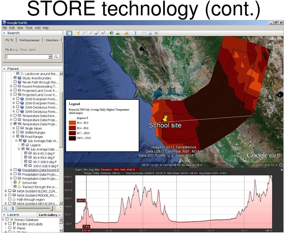
17 ARC GIS Explorer interface

18 STORE Basic Lesson 2 Students compare average temperatures and annual precipitation totals along a transect of different weather stations at different elevations in order to see the orographic effect in action

19 Adaptations of STORE Original Lesson 2 by New York teachers for New York State (NYS) data Students asked to sketch on paper a graph showing the relationship between elevation and temperature? The explicitness of this task: Describe the general pattern of temperatures in New York State (NYS) along an East/West Line that goes through Syracuse" as opposed to too-vague questions like "Describe the data" Students prompted to think about whether there would be trends if you are looking at a strictly north-south or east-west transect (which helps students to discover themselves that longitude or latitude is not by itself an indicator of such trends in a small region like NYS. Students asked: The relationship between temperature and elevation is seldom perfect across specific areas of NYS. What other variables might impact the patterns that you observed? Where do they occur?"

20 Teacher peer review of each other s adaptations Example California teachers praise the explicitness of a NYS teacher s map analysis prompt: Describe the general pattern of temperatures in New York State (NYS) along an East/West Line that goes through Syracuse" as an improvement over questions like "Describe the data" and What do the data look like?

21 Some teachers opt to create new lessons Example: Extending the inquiry to animal species The following is a list of special-status land animals in California. These animals are listed as endangered or sensitive, and they may be sensitive to climate change. Your job is to look-at the geographic area you are studying (the STORE California Study Area), find one of these animals that inhabits your expertise area (land-cover range) within the study area, and make an educated guess on how the animal might be affected by the shift in range you've predicted in the last lab. Present your research and your hypothesis in 3-4 slides, and include images of the animal. Create a Google Earth image of the current and predicted ranges of your animal in 2050 and 2099, and be prepared to answer questions on how you arrived at this prediction. Make notes on the above research, then discuss and formulate a hypothesis on how the animal will react and adapt to the climate change and land cover change you've predicted.
22 STORE Advanced Lessons 1 and 2 Students analyze projected ranges of vegetation types in 2050 in relation on projected temperatures and precipitation amounts.
23 Teacher-developed extension lesson (cont.) Some information to include in your investigation: Current range of the animal relationship of the animal to the plant community it inhabits (symbiosis?) the animals' eating and sleeping habits (will its diet be effected by a shift in plant range?) the animals' temperature and moisture comfort range and adaptability the animals' breeding cycle and habits around rearing young (are these based in any way on temperature, precipitation, and surrounding vegetation)? any anecdotal information unique to the animal that is predictive of its ability to react to climate change (i.e. if the animal lays eggs in shallow puddles, it can't live with a significant reduction in rainfall).
24 DICCE Structure
25 DICCE Technology Have the teacher query large data portal for images
26 DICCE Technology Give students images to analyze, in teacher-authored lessons Provide item bank from which to choose aligned near transfer tasks for assessment purposes (in progress)
27 DICCE Technology Provide additional supports for the teacher to make available to the students
SRI International. Data Enhanced Investigations for Climate Change Education. Year 1 Annual Report (November 1, 2010 - October 31, 2011)
") SRI International August 31, 2011 Data Enhanced Investigations for Climate Change Education Year 1 Annual Report (November 1, 2010 - October 31, 2011) NNX10AT54A SRI Project P19804 Submitted to: Andi Geyer
SRI International August 31, 2011 Data Enhanced Investigations for Climate Change Education Year 1 Annual Report (November 1, 2010 - October 31, 2011) NNX10AT54A SRI Project P19804 Submitted to: Andi Geyer
Studying Topography, Orographic Rainfall, and Ecosystems (STORE)
") Studying Topography, Orographic Rainfall, and Ecosystems (STORE) Introduction Basic Lesson 2: Using ArcGIS Explorer to Analyze the Connection between Topography and Rainfall This lesson introduces Geographical
Studying Topography, Orographic Rainfall, and Ecosystems (STORE) Introduction Basic Lesson 2: Using ArcGIS Explorer to Analyze the Connection between Topography and Rainfall This lesson introduces Geographical
Studying Topography, Orographic Rainfall, and Ecosystems (STORE)
") Studying Topography, Orographic Rainfall, and Ecosystems (STORE) Basic Lesson 3: Using Microsoft Excel to Analyze Weather Data: Topography and Temperature Introduction This lesson uses NCDC data to compare
Studying Topography, Orographic Rainfall, and Ecosystems (STORE) Basic Lesson 3: Using Microsoft Excel to Analyze Weather Data: Topography and Temperature Introduction This lesson uses NCDC data to compare
Geographical Information Systems (GIS) in Education Alexis Pang
 in Education Alexis Pang") Geographical Information Systems (GIS) in Education Alexis Pang Introduction The aim of this literature review is to provide educators with a basic understanding of Geographical Information Systems (GIS),
Geographical Information Systems (GIS) in Education Alexis Pang Introduction The aim of this literature review is to provide educators with a basic understanding of Geographical Information Systems (GIS),
BOILING AND PEELING OF EGGS
 Sample Lesson Plan for Teachers under the Ark of Inquiry Project Ark of Inquiry: Inquiry Awards for Youth over Europe is a project on teacher training, oriented towards raising science awareness, particularly
Integrated STEM Education through Project-Based Learning
 Integrated STEM Education through Project-Based Learning by Diana Laboy-Rush, STEM Solutions Manager at Learning.com Table of Contents: Abstract...2 Math and Science Education Crisis...3 Integrated STEM
GLOBAL-READY TEACHER COMPETENCY FRAMEWORK: STANDARDS AND INDICATORS
 GLOBAL-READY TEACHER COMPETENCY FRAMEWORK: STANDARDS AND INDICATORS GLOBAL-READY TEACHER COMPETENCY FRAMEWORK All learners whether adult or child acquire the attitudes, skills and knowledge needed for
A Correlation of Environmental Science Your World, Your Turn 2011
 A Correlation of Your World, Your Turn 2011 To Ohio s New Learning Standards for Science, 2011, High School Science Inquiry and Application Course Content INTRODUCTION This document demonstrates how Pearson,
NCSS Standards 1. d. compare ways in which people from different cultures think about and deal with their physical environment and social conditions;
 NCSS Standards 1 National Council for the Social Studies (NCSS) Curriculum Standards for Social Studies Standard I. Culture study of culture and cultural diversity, so that the learner can a. explore and
GEOGRAPHIC INFORMATION SYSTEMS
 GEOGRAPHIC INFORMATION SYSTEMS WHAT IS A GEOGRAPHIC INFORMATION SYSTEM? A geographic information system (GIS) is a computer-based tool for mapping and analyzing spatial data. GIS technology integrates
Principal Practice Observation Tool
 Principal Performance Review Office of School Quality Division of Teaching and Learning Principal Practice Observation Tool 2014-15 The was created as an evidence gathering tool to be used by evaluators
LEOworks - a freeware to teach Remote Sensing in Schools
 LEOworks - a freeware to teach Remote Sensing in Schools Wolfgang Sulzer Institute for Geography and Regional Science University of Graz Heinrichstrasse 36, A-8010 Graz/Austria wolfgang.sulzer@uni-graz.at
P21 Framework Definitions
 P21 Framework Definitions To help practitioners integrate skills into the teaching of core academic subjects, the Partnership has developed a unified, collective vision for learning known as the Framework
Geotagging photos to share field trips with the world The basics Geo-tagging: a range of teaching and learning opportunities Example Details
 Geotagging photos to share field trips with the world During the past few years, numerous new online tools for collaboration and community building have emerged, providing web-users with a tremendous capability
A CONTENT STANDARD IS NOT MET UNLESS APPLICABLE CHARACTERISTICS OF SCIENCE ARE ALSO ADDRESSED AT THE SAME TIME.
 Environmental Science Curriculum The Georgia Performance Standards are designed to provide students with the knowledge and skills for proficiency in science. The Project 2061 s Benchmarks for Science Literacy
PART 1. Representations of atmospheric phenomena
 PART 1 Representations of atmospheric phenomena Atmospheric data meet all of the criteria for big data : they are large (high volume), generated or captured frequently (high velocity), and represent a
Microclimate in the Outdoor Classroom
 Microclimate in the Outdoor Classroom 1. CONTRIBUTOR S NAME: TJ FONTAINE 2. NAME OF INQUIRY: MICROCLIMATE IN THE OUTDOOR CLASSROOM 3. GOALS AND OBJECTIVES: TEACH STUDENTS ABOUT THE SIMULARITIES AND DIFFERENCES
Chapter 4: Types of coaching
 Tool 4.1 Relationship between training outcomes and training components Purpose Use this tool to demonstrate the impact of coaching on teachers practices. 4.2 Coaching interactions Gain an understanding
Natural Disasters. Proudly supported by
 Natural Disasters Proudly supported by 3 3 SPRINGBOARD THREE Natural Disasters Young Shelterbox Year 6 This unit explores how sudden geological changes or extreme weather conditions can affect the Earth
GIS Initiative: Developing an atmospheric data model for GIS. Olga Wilhelmi (ESIG), Jennifer Boehnert (RAP/ESIG) and Terri Betancourt (RAP)
, Jennifer Boehnert (RAP/ESIG) and Terri Betancourt (RAP)") GIS Initiative: Developing an atmospheric data model for GIS Olga Wilhelmi (ESIG), Jennifer Boehnert (RAP/ESIG) and Terri Betancourt (RAP) Unidata seminar August 30, 2004 Presentation Outline Overview
GIS Initiative: Developing an atmospheric data model for GIS Olga Wilhelmi (ESIG), Jennifer Boehnert (RAP/ESIG) and Terri Betancourt (RAP) Unidata seminar August 30, 2004 Presentation Outline Overview
North Carolina Professional Technology Facilitator Standards
 North Carolina Professional Technology Facilitator Standards Every public school student will graduate from high school, globally competitive for work and postsecondary education and prepared for life
Creating Curricula for a Sustainable Future: A Team-based, Rubric-supported Approach
 Creating Curricula for a Sustainable Future: A Team-based, Rubric-supported Approach Anne E. Egger, Central Washington University Hannah Scherer, Virginia Tech Transforming STEM Higher Education AAC&U
Stages of Instructional Design V. Professional Development
 Stages of Instructional Design V. Professional Development Derived from Gagné, R. M., Briggs, L. J., & Wager, W. W. (1992). Principles of Instructional Design (4th ed.). Fort Worth, TX: Harcourt Brace
Third Grade Science Curriculum
 Third Grade Science Curriculum Approved July 12, 2004 The Georgia Performance Standards are designed to provide students with the knowledge and skills for proficiency in science at the third grade level.
A STUDY OF BIOMES. In this module the students will research and illustrate the different biomes of the world.
 A STUDY OF BIOMES http://bellnetweb.brc.tamus.edu/res_grid/biomes.htm A HIGH SCHOOL BIOLOGY / ECOLOGY MODULE Summary: In this module the students will research and illustrate the different biomes of the
USING VARIED INSTRUCTIONAL TECHNIQUES: INDUCTIVE and DEDUCTIVE TEACHING APPROACHES
 USING VARIED INSTRUCTIONAL TECHNIQUES: INDUCTIVE and DEDUCTIVE TEACHING APPROACHES In order to meet the needs of diverse learners in a biology classroom, it is important to vary the approach to teaching
Position Statement on Science Education
 Connecticut State Board of Education Hartford Position Statement on Science Education Adopted September 3, 2008 The Connecticut State Board of Education regards scientific literacy as evidence of a high-quality
etips--educational Technology Integration and Implementation Principles
 56 Dexter Chapter III etips--educational Technology Integration and Implementation Principles Sara Dexter University of Minnesota, USA WHY A SET OF PRINCIPLES TO GUIDE TEACHERS ABOUT INTEGRATING AND IMPLEMENTING
p e d a g o g y s t r a t e g y MCEETYA A u s t r a l i a N e w Z e a l a n d
 p e d a g o g y s t r a t e g y MCEETYA A u s t r a l i a N e w Z e a l a n d Pedagogies that integrate information and communication technologies can engage students in ways not previously possible, enhance
Standards: Human activity has consequences on living organisms and ecosystems. (94412, 94211 )
") Minnehaha Creek Restoration Project A Place- Based Environmental Water Study Course: 9 th grade Biology Adapted from Kent Piccott, Minneapolis Public Schools Background: This study was designed with the
Minnehaha Creek Restoration Project A Place- Based Environmental Water Study Course: 9 th grade Biology Adapted from Kent Piccott, Minneapolis Public Schools Background: This study was designed with the
Evidence of Complex Reasoning in Technology and Science: Notes From Inner City Detroit, Michigan, USA
 Evidence of Complex Reasoning in Technology and Science: Notes From Inner City Detroit, Michigan, USA Nancy Butler Songer Professor, Learning Technologies and Science Education School of Education, The
JOINT MASTER OF ARTS IN LEADERSHIP AND EDUCATION CHANGE COURSE DESCRIPTIONS
 JOINT MASTER OF ARTS IN LEADERSHIP AND EDUCATION CHANGE COURSE DESCRIPTIONS A. CORE COURSES MALC 801 Perspectives in Educational Leadership Educational leadership is a complex concept, both in theory and
Numbers Plus Preschool Mathematics Curriculum: Teacher s Manual
 Number and operations involves understanding whole numbers and realizing that numbers represent quantity. It includes learning number words and symbols, counting, comparing and ordering quantities, composing
How To Improve The Education Experience At An Ib World School
 The Diploma Programme Online: New Developments New Relationships New Courses New Opportunities Page 0 0 Today s agenda 1. Introductions 2. The Diploma Programme (DP) Online a) Background and purpose b)
Course Description \ Bachelor of Primary Education Education Core
 Course Description \ Bachelor of Primary Education Education Core EDUC 310 :Foundations of Education in Qatar and School Reform : This course has been designed to acquaint the learners with the progress
PROVINCE OF THE EASTERN CAPE EDUCATION
 PROVINCE OF THE EASTERN CAPE EDUCATION DIRECTORATE: FET CURRICULUM FET PROGRAMMES LESSON PLANS TERM 4 LIFE SCIENCES GRADE 11 FOREWORD The following Grade 11 Lesson Plans were developed by Subject Advisors
Addressing the Challenges of Inquiry-Based Learning through Technology and Curriculum Design
 Addressing the Challenges of Inquiry-Based Learning through Technology and Curriculum Design Daniel C. Edelson Institute for the Learning Sciences and School of Education and Social Policy Northwestern
In this lesson, students will identify a local plant community and make a variety of
 MAKING COMMUNITY MEASUREMENTS: ABIOTIC FACTORS Grades 3 6 I. Introduction In this lesson, students will identify a local plant community and make a variety of measurements, preferably during two different
Talent Development Secondary Assessment, Curriculum, and Instruction Blueprint Practices to Support a Culture of Success
 Talent Development Secondary Assessment, Curriculum, and Instruction Blueprint Practices to Support a Culture of Success The Blueprint: The Blueprint targets curriculum, instruction and assessment as key
Range Management Databases on the Web: Two Examples
 Range Management Databases on the Web: Two Examples George Ruyle, Chair, Rangeland & Forest Research Program, School of Renewable Natural Resources, Biological Sciences East 302, University of Arizona,
A Correlation of Miller & Levine Biology 2014
 A Correlation of Miller & Levine Biology To Ohio s New Learning Standards for Science, 2011 Biology, High School Science Inquiry and Application Course Content A Correlation of, to Introduction This document
Monitoring Phenology Activity
 Monitoring Phenology Activity Exploring the PhenoCam Locations Introduction In this activity students become familiar with the PhenoCam website and the network by comparing the images from diverse PhenoCam
Leading Edge Technology Initiative. Virtualizing the GIS Application Desktop through Remote Connect Technology
 Leading Edge Technology Initiative Virtualizing the GIS Application Desktop through Remote Connect Technology Vince DiNoto Dean of System Initiatives Kentucky Community and Technical College System Currently,
Climate Change: A Local Focus on a Global Issue Newfoundland and Labrador Curriculum Links 2010-2011
 Climate Change: A Local Focus on a Global Issue Newfoundland and Labrador Curriculum Links 2010-2011 HEALTH Kindergarten: Grade 1: Grade 2: Know that litter can spoil the environment. Grade 3: Grade 4:
RUTHERFORD HIGH SCHOOL Rutherford, New Jersey COURSE OUTLINE ENVIRONMENTAL SCIENCE
 RUTHERFORD HIGH SCHOOL Rutherford, New Jersey COURSE OUTLINE ENVIRONMENTAL SCIENCE I. INTRODUCTION Environmental Science introduces students to a broad view of the biosphere and the physical parameters
Master Technology Teacher Standards
 Master Technology Teacher Standards FINAL Approved on January 4, 2002 Texas State Board for Educator Certification MASTER TECHNOLOGY TEACHER STANDARDS Standard I. Standard II. Standard III. Standard IV.
Global Climate Change WebQuest
 Global Climate Change WebQuest In this activity, students explore key indicators of global climate change and consider strategies for adaptation/mitigation. This activity could be used before global climate
The UCC-21 cognitive skills that are listed above will be met via the following objectives.
 Master Syllabus Department of Geography GEOG 265: Introduction to Geographic Information Systems Course Description Fundamentals of geographic information systems (GIS). How to visualize geographic information
A Vision and Framework for 21st Century Teaching & Learning. Every Child.Every Day
 A Vision and Framework for 21st Century Teaching & Learning Every Child.Every Day How do we prepare students to be life-long learners and to master the knowledge, skills and expertise that they need to
Integrating Co-Design Practices into the Development of Mobile Science Collaboratories
 Integrating Co-Design Practices into the Development of Mobile Science Collaboratories Daniel Spikol, Marcelo Milrad, Heidy Maldonado*, Roy Pea* Center for Learning and Knowledge Technologies (CeLeKT)
Digital Literacy: Theoretical Framework
 Digital Literacy: Theoretical Framework September 2014 Table of Contents Definition... 1 Key Concepts... 1 Digital Literacy Competencies... 2 Digital Literacy and Student Centered Learning... 9 Generous
Introduction to GIS (Basics, Data, Analysis) & Case Studies. 13 th May 2004. Content. What is GIS?
 & Case Studies. 13 th May 2004. Content. What is GIS?") Introduction to GIS (Basics, Data, Analysis) & Case Studies 13 th May 2004 Content Introduction to GIS Data concepts Data input Analysis Applications selected examples What is GIS? Geographic Information
Introduction to GIS (Basics, Data, Analysis) & Case Studies 13 th May 2004 Content Introduction to GIS Data concepts Data input Analysis Applications selected examples What is GIS? Geographic Information
GIS: Geographic Information Systems A short introduction
 GIS: Geographic Information Systems A short introduction Outline The Center for Digital Scholarship What is GIS? Data types GIS software and analysis Campus GIS resources Center for Digital Scholarship
Introduction to GIS software
 Introduction to GIS software There are a wide variety of GIS software packages available. Some of these software packages are freely available for you to download and could be used in your classroom. ArcGIS
Please see the Seasonal Changes module description.
 Overview Children will measure and graph the precipitation on the playground throughout the year using a rain gauge. Children will also observe satellite images of clouds and begin to investigate how clouds
Managing Inquiry-Based Science: Challenges in Enacting Complex Science Instruction in Elementary and Middle School Classrooms
 J Sci Teacher Educ (2010) 21:227 240 DOI 10.1007/s10972-009-9172-5 Managing Inquiry-Based Science: Challenges in Enacting Complex Science Instruction in Elementary and Middle School Classrooms Christopher
Earth, Moon, and Sun Inquiry Template Eclipses
 One Stop Shop For Educators The following instructional plan is part of a GaDOE collection of Unit Frameworks, Performance Tasks, examples of Student Work, and Teacher Commentary. Many more GaDOE approved
Gray Whales on the Move
 Gray Whales on the Move Students trace the migration route of a gray whale and discover the gray whale s natural history. Subjects Science GRADE LEVEL Grades 6 8 TIME 60 minutes OBJECTIVES Students will
AND LEARNING 21st Century Teaching and Learning
 21ST CENTURY TEACHING AND LEARNING 21st Century Teaching and Learning Dr. Grace Surdovel, Director of Master's Programs/Faculty of Practice The Master of Science in Education with a major in 21st Century
CO-DESIGNING A KNOWLEDGE BUILDING ACTIVITY WITH SECONDARY SCHOOL BIOLOGY TEACHERS
 CO-DESIGNING A KNOWLEDGE BUILDING ACTIVITY WITH SECONDARY SCHOOL BIOLOGY TEACHERS Vanessa L. Peters Ontario Institute for Studies in Education University of Toronto vpeters@oise.utoronto.ca James D. Slotta
Approved July 12, 2004
 Fifth Grade Science Curriculum The Georgia Performance Standards are designed to provide students with the knowledge and skills for proficiency in science at the fifth grade level. The Project 2061 s Benchmarks
Wildfire Prevention and Management in a 3D Virtual Environment
 Wildfire Prevention and Management in a 3D Virtual Environment M. Castrillón 1, P.A. Jorge 2, I.J. López 3, A. Macías 2, D. Martín 2, R.J. Nebot 3,I. Sabbagh 3, J. Sánchez 2, A.J. Sánchez 2, J.P. Suárez
Rational for Lesson Plan Re-design:
 Rational for Lesson Plan Re-design: For this assignment I chose to re-design a project that I give to my students at the end of third quarter. The original lesson is to have students build a model volcano
Sample Unit Plan. Ecology Explorers
 Appendix G.04 Appendix G: Seeing Reason Tool Resources Sample Unit Plan Ecology Explorers Classroom Information Subject Area Science, Language Arts Grade Level(s) 6 8 Unit Summary In this project, students
TExMaT Master Science Teacher 4 8 (091) Test at a Glance
 Test at a Glance") TExMaT Master Science Teacher 4 8 (091) Test at a Glance See the test preparation manual for complete information about the test along with sample questions, study tips and preparation resources. Test
TExMaT Master Science Teacher 4 8 (091) Test at a Glance See the test preparation manual for complete information about the test along with sample questions, study tips and preparation resources. Test
DESCRIBING DESERT, TAIGA, AND TUNDRA BIOMES
 Lesson B5 1 DESCRIBING DESERT, TAIGA, AND TUNDRA BIOMES Unit B. Science and Technology in Wildlife Management Problem Area 5. Desert, Taiga, and Tundra Biomes National Academic Standard. NS.9-12.1 Science
Table of Contents Section 8: How Children Learn
 Table of Contents Section 8: How Children Learn This section provides educators with information about educational theories and objectives and how these apply to a unit of study on the West Eugene Wetlands.
Universal Design for Learning
 Universal Design for Learning Meeting Everyone s Needs From the Start May 5, 2016 Locate our Tools http://tinyurl.com/eacxudl Objectives What is Universal Design for Learning (UDL) Why to consider UDL
Common Core and Universal Design for Learning: Balancing Rigor and Access for All IRA April 19, 2013. Lori DiGisi, Framingham
 Common Core and Universal Design for Learning: Balancing Rigor and Access for All IRA April 19, 2013 Lori DiGisi, Framingham 1 Public Schools Peggy Coyne, CAST Goal As states and districts produce CCSS
Why dread a bump on the head?
 Why dread a bump on the head? The neuroscience of traumatic brain injury Lesson 6: Exploring the data behind brain injury I. Overview This lesson exposes students to the role data access and analysis can
Project-Based Cartographic Learning in an Advanced Technology Classroom. Brian P. Bailey
 Project-Based Cartographic Learning in an Advanced Technology Classroom Brian P. Bailey Department of Geography and Environmental Engineering United States Military Academy West Point, NY 10996 Tel: 845-938-4620
Signs of the Seasons: A Maine Phenology Project
 Signs of the Seasons: A Maine Phenology Project http://umaine.edu/signs- of- the- seasons/ Mapping and Graphing Your Phenology Observations Authors: Beth Bisson 1, Medea Steinman 2, and Esperanza Stancioff
COASTAL MONITORING & OBSERVATIONS LESSON PLAN Do You Have Change?
 Coastal Change Analysis Lesson Plan COASTAL MONITORING & OBSERVATIONS LESSON PLAN Do You Have Change? NOS Topic Coastal Monitoring and Observations Theme Coastal Change Analysis Links to Overview Essays
Available in English and Spanish
 Grades K 8+ Content Literacy Supports Common Core Available in English and Spanish Literacy Development and Grade-Level Content Language, Literacy, & Vocabulary builds a strong foundation for literacy
Plant and Animal Adaptations [4th grade]
![Plant and Animal Adaptations [4th grade]](/thumbs/40/21190579.jpg "Plant and Animal Adaptations [4th grade]") Trinity University Digital Commons @ Trinity Understanding by Design: Complete Collection Understanding by Design 6-14-2006 Plant and Animal Adaptations [4th grade] Jennifer Mahler Trinity University Follow
Trinity University Digital Commons @ Trinity Understanding by Design: Complete Collection Understanding by Design 6-14-2006 Plant and Animal Adaptations [4th grade] Jennifer Mahler Trinity University Follow
INDIVIDUAL COURSE DETAILS
 INDIVIDUAL COURSE DETAILS A. Name of Institution NATIONAL INSTITUTE OF TECHNICAL TEACHERS TRAINING AND RESEARCH TARAMANI CHENNAI 600 113 [An Autonomous Institute under Ministry of Human Resource Development,
CLIDATA In Ostrava 18/06/2013
 CLIDATA In Ostrava 18/06/2013 Content Introduction...3 Structure of Clidata Application...4 Clidata Database...5 Rich Java Client...6 Oracle Discoverer...7 Web Client...8 Map Viewer...9 Clidata GIS and
Blackburn College Teaching, Learning and Assessment Strategy. 25 August 2015
 Blackburn College Teaching, Learning and Assessment Strategy 25 August 2015 1 Introduction This document provides a Teaching, Learning and Assessment Strategy covering all of the College s Further Education
FAIRFIELD PUBLIC SCHOOLS K-12 Library Media Department DRAFT. Library Media Curriculum Linking Core Curriculum with 21 st Century Skills
 FAIRFIELD PUBLIC SCHOOLS K-12 Library Media Department Library Media Curriculum Linking Core Curriculum with 21 st Century Skills DRAFT Draft September, 2014 1 Fairfield Public Schools Library Media Department,
Geospatial Software Solutions for the Environment and Natural Resources
 Geospatial Software Solutions for the Environment and Natural Resources Manage and Preserve the Environment and its Natural Resources Our environment and the natural resources it provides play a growing
Curriculum Material and Activities of Climate Education:
 Curriculum Material and Activities of Climate Education: Education Link Website Union of Concerned Scientists develop the global warming: Early Warning Signs Map a science-based world map depicting the
Qatari K-12 Education - Problem Solving Climate Crisis
 SESRI Policy & Program Evaluation Workshop Doha, Qatar January 19-22, 2015 Outline: Session 5 Measurement: Benchmarking in Evaluation Design Quasi-experimental research designs: Combining evaluation with
Microsoft in Education. Microsoft Certified Educator Study Guide
 Microsoft in Education Microsoft Certified Educator Study Guide Resources The Microsoft Certified Educator and Teaching with Technology programs are part of a rich set of professional development, assessment,
SWMP/IOOS Real-Time Data in K-12 Classrooms: A Front-end Evaluation Final Report Executive Summary September 2006
 Rutgers University Institute of Marine & Coastal Sciences & Jacques Cousteau National Estuarine Research Reserve SWMP/IOOS Real-Time Data in K-12 Classrooms: A Front-end Evaluation Final Report Executive
Mary Beth Parkinson, MCCC Sarah Hartman-Caverly, DCCC
 Mary Beth Parkinson, MCCC Sarah Hartman-Caverly, DCCC Learning Goals Identify characteristics of inquiry-guided learning (IGL) Apply concepts of IGL to IL lessons Apply a Frame to an IL lesson plan Translate
DIABLO VALLEY COLLEGE CATALOG 2015-2016
 GEOGRAPHY GEOG Tish Young, Dean Physical Sciences and Engineering Division Physical Sciences Building, Room 263 Possible career opportunities Geography is an interdisciplinary study focusing on the spatial
The Open University s repository of research publications and other research outputs
 Open Research Online The Open University s repository of research publications and other research outputs Supporting location-based inquiry learning across school, field and home contexts Conference Item
Does Artificial Tutoring foster Inquiry Based Learning?
 Vol. 25, Issue 1, 2014, 123-129 Does Artificial Tutoring foster Inquiry Based Learning? ALEXANDER SCHMOELZ *, CHRISTIAN SWERTZ, ALEXANDRA FORSTNER, ALESSANDRO BARBERI ABSTRACT: This contribution looks
Team California for Healthy After Schools (TCHAS) Nutrition Education Supplemental Materials
 Nutrition Education Supplemental Materials") Team California for Healthy After Schools (TCHAS) Nutrition Education Supplemental Materials These materials are to enhance TCHAS nutrition education programs and to use in conjunction with the core curricula
Team California for Healthy After Schools (TCHAS) Nutrition Education Supplemental Materials These materials are to enhance TCHAS nutrition education programs and to use in conjunction with the core curricula
RUTHERFORD PUBLIC SCHOOLS ENVIRONMENTAL SCIENCE CURRICULUM GRADE 7
 RUTHERFORD PUBLIC SCHOOLS ENVIRONMENTAL SCIENCE CURRICULUM GRADE 7 I. INTRODUCTION The overall intent for the environmental studies course is to expose seventh grade students to a multitude of environmental
Candidates will demonstrate ethical attitudes and behaviors.
 EDET 628 Apply instructional design principles to create a unit of instruction which integrates technology and enhances student understanding Demonstrate purposeful alignment of state competencies and
Oil Spill! Clean it Up!!!!!
 Oil Spill! Clean it Up!!!!! Document Overview: Lesson Overview Video Clip Links Student Handout Minnesota State Science Standards: 9.1.1.2.1 Formulate a testable hypothesis, design and conduct an experiment
Reflecting on Learning Support Roles to Enhance Instructional Effectiveness
 Reflecting on Learning Support Roles to Enhance Instructional Effectiveness A framework for strategically choosing and using online tools DePaul University Teaching and Learning Conference 2015 May 1,
Rubric for Evaluating North Carolina s Instructional Technology Facilitators
 Rubric for Evaluating North Carolina s Instructional Technology Facilitators Standard 1: Instructional Technology Facilitators demonstrate leadership. Not Demonstrated Developing Proficient Accomplished
An explanation of the coding of the science GPS is attached.
 Entomology Curriculum The Georgia Performance Standards are designed to provide students with the knowledge and skills for proficiency in science. The Project 2061 s Benchmarks for Science Literacy is
Participant Guidebook
 Participant Guidebook Module 1 Understand Teacher Practice Growth through Learning s Module 1 Understand Teacher Practice Guidebook 1 Participant Guidebook Overview Based upon successful completion of
About Google Earth. A Great Way to Engage and Inspire Students
 About Google Earth A Great Way to Engage and Inspire Students Google Earth is an amazing tool that will keep your learners interested and engaged in learning! You can use it across the curriculum. 1 Scenario
Stage 4. Geography. Blackline Masters. By Karen Devine
 1 Devine Educational Consultancy Services Stage 4 Geography Blackline Masters By Karen Devine Updated January 2010 2 This book is intended for the exclusive use in NSW Secondary Schools. It is meant to
Implementing Geospatial Data in Parametric Environment Elçin ERTUĞRUL*
 Proceedings of the International Association for Shell and Spatial Structures (IASS) Symposium 2015, Amsterdam 17-20 August 2015, Amsterdam, The Netherlands Implementing Geospatial Data in Parametric Environment
SESSION 2: THE CLASSROOM PRODUCTIVITY CENTER Introduction Software Activities Web Activities Create Your Productivity Center Look Ahead
 Introduction Good teachers are always thinking about how they can make their classrooms a little better. When they try something new, they re always thinking about how to refine it, experiment with it,