Neotectonics and Seismicity of Turkey. ITU Eurasia Institute of Earth Sciences 2005
|
|
|
- Cassandra Barrett
- 8 years ago
- Views:
Transcription
1 Neotectonics and Seismicity of Turkey Okan TüysT ysüz ITU Eurasia Institute of Earth Sciences 2005

2 Turkey forms one of the youngest and most active part of the Alpide Orogenic System

3 TECTONICS of TURKEY The Alpide orogenic system is created by the closing of different branches of Tethys Ocean During the closing of Tethys, different continental fragments belonging to Gondwana and Laurasia collided and amalgamated into each other. Turkey is an orogenic collage created by these amalgamated continental fragments and the remnants of oceanic environments separating them.

4 PALAEOTECTONIC UNITS of TURKEY Okay&Tüysüz, 1999

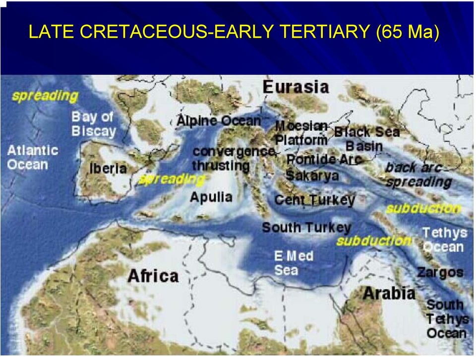
5 LATE CRETACEOUS-EARLY EARLY TERTIARY (65 Ma)
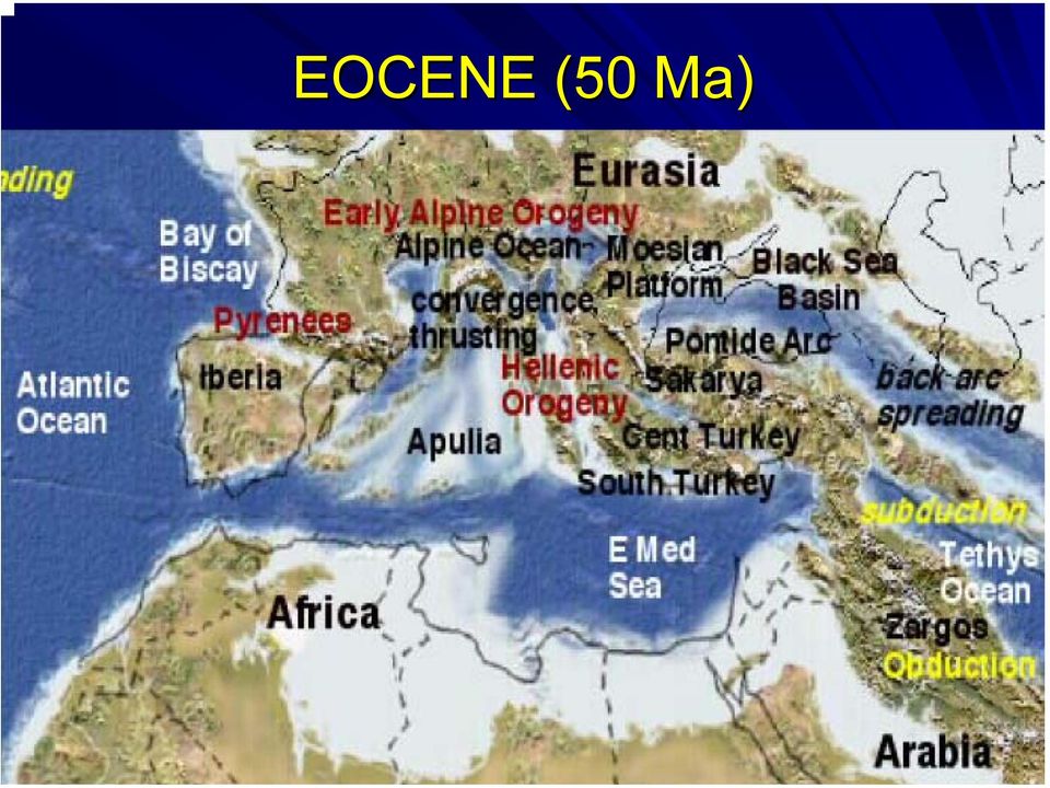
6 EOCENE (50 Ma)
7 LATE MIOCENE (11 Ma)

8 NEOTECTONIC PERIOD After the closing of the Tethys Ocean along the Bitlis- Zagros suture 11 Ma ago Palaetoectonic period ended and Neotectonic period has started for Turkey. During the neotectonic period, the Arabian Peninsula continued to move northward along the Dead Sea Fault and created a compressional tectonic regime in the Eastern Anatolia. This compressional regime resulted in crustal thickening and uplifting ing in the Eastern E Anatolia between 11 and 5 Ma, During this time east west trending reverse faults and thrusts, folds, and some ramp basins have been developed During the beginning of the Pliocene (~5 Ma) this compressional tectonic regime was replaced by escape regime

9 The Anatolian Plate started to move westward along two transform faults,, North Anatolian and East Anatolian Fault Zones.

10 The Arabian plate is moving northward at a rate of 18 mm/y and the Anatolian Plate is still moving westward and rotating anticlockwise around a pole in Sınai S Peninsula

11 Northward moving of the Arabian Plate and westward extrusion of the Anatolian Plate created four neotectonic provinces: 1. East Anatolian Contractional Province, 2. North Anatolian Province, 3. Central Anatolian Ova Province and 4. West Anatolian Extensional Province. These provinces are delimited by 1. The North Anatolian Fault Zone 2. The East Anatolian Fault Zone 3. Dead Sea Fault Zone 4. The Aegean Cypr Cyprus Arc Bozkurt, 2001

12 East Anatolian Contractional Province NE- and NW-trending conjugate strike-slip slip faults Pull-apart basins (Erzurum and Ağrı basins) along the strike-slip slip faults E W W trending compressional ramp basins (Muş,, Van and Pasinler) N-S S trending tensional cracks Koçyiğit et al., 2001 Bozkurt, 2001
 N-S S trending tensional cracks Koçyiğit et al.")
13 IMPORTANT ACTIVE FAULTS Northeasternern Anatolian Fault Iğdır, Balıkg kgölü and Doğubayaz ubayazıt Ağrı,Karayazı, Çaldıran, Horasan and Erciş Yüksekova Şemdinliemdinli

14 Northeastern Anatolian Fault Zone Left-lateral 350 km-long Slip rates of 8 mm/a according to GPS measurements Average mm/a according to geological data Consists of Kelkit, Dumlu-Çobandede and Kağı ğızman Fault Zones Bozkurt, 2001

15 Koçyiğit et al., 2001 KAĞIZMAN ZONE DUMLU-ÇOBANDEDE ZONE KELKİT ZONE

16 Major earthquakes in the East Anatolian Contractional Province during the 20 th Century 12 July 1900 Kağı ğızman (M=( 5.9) 8 November 1901 Erzurum (M=6.1( M=6.1) 28 April 1903 Patnos (M=6.3( M=6.3) 28 May 1903 Ardahan (M=( 5.7) 4 December 1905 Malatya (M=( 6.8) 13 September 1924 Horasan (M M = 6.8) 1 May 1935 Digor (M=( 5.8) 10 September 1941 Erciş (M= 5.9) 6 September 1975 Lice (M( M = 6.6) 24 November 1976 Çaldıran (M M = 7.3) 30 October 1983 Horasan Narman (M M = 6.8)
 10 September 1941 Erciş (M= 5.9) 6 September 1975 Lice (M( M = 6.6) 24 November 1976 Çaldıran (M M = 7.")
17 East Anatolian Contractional Province N S compression also created N-S N S trending tensional cracks,, which have functioned as magma conduits. Plio-Quaternary distinct volcanoes are Nemrut, Süphan, Ağrı, Tendürek etc. NEMRUT Koçyiğit et al., 2001

18 North Anatolian Province Delimited by NAF and NEAF E-W W trending fold and thrust belt. The slip rates are less than 5 mm/y 3 September 1968 Bartın earthquake (M = 6.8) Tarı et al., 2000

19 Central Anatolian Ova Province Delimited by NAF and EAF Characterized by extensional basins called ovas, Basin bounding oblique faults. Eastern part is deformed by a number dextral and sinistral strike-slip slip faults,, which are splays of the NAFZ, and form a fishbone structure Normal faults are dominant in the western part.

20 IMPORTANT ACTIVE FAULTS Ecemiş Ovacık-Malatya Yakapınar-Göksun and Kangal Ezinepazar- Sungurlu Laçin-Merzifon Kırşehir Almus Tuzgölü Bozkurt, 2001

21 The Ovacık Malatya Fault Zone Sinistral 2500 km long. Splays from the NAF near Erzincan. Consists two main segments; Ovacık segment Malatya segment Bozkurt, 2001
22 The Ecemiş Fault Zone Sinistral 7000 km long Formed by the reactivation of a palaeotectonic structure in the Plio- Quaternary. Seismically less active Total displacements during the palaeotectonic and neotectonic periods are 707 km and 24 km, respectively. Some pull-apart basins (Erciyes, Tuzla, Sultansazlığı ığı) Bozkurt, 2001
23 The Tuzgölü Fault Zone Dextral 200 km long, The initiation is Late Cretaceous,, becameb active during the Miocene. The N S N S and NE SW trending volcanic cones along the fault are attributed this fault Bozkurt, 2001
24
25 Seismicity of the eastern part of the Central Anatolian Province 1717 and 1835 Ecemiş 9 March 1902 Çankırı (Ms=5.5) May 1914 Gemerek (M M = 5.6) 1938 Kırşehir (M M = 6.8) 21 February 1940 Erciyes (M M = 5.1) 13 April 1940 Yozgat-Kayseri (M( M =5.3) 4 August 1996 Mecitözü Çorum (M( M = 5.6)
26 Western Part of the Central Anatolia NE SW (Burdur, Acıgöl, Sandıkl klı, Çivril and Dombayova) and NW SE SE- trending (Dinar, Beyşehir ehir, Akşehir ehir Afyon ) cross- grabens and horsts Forms a transition between the Aegean Extensional Province and the strike-slip slip dominant eastern part of the Central Anatolia. Southern part of this region is known as the Isparta angle. Bozkurt, 2001
27 Eskişehir Fault Dextral with normal component. Ruptured during the 1956 Eskişehir earthquake (M = 6.5) Forms boundary between Central and Western Anatolia Bozkurt, 2001 Barka, 1996
28 Fethiye Burdur Fault Zone Left-lateral Forms the boundary between the Western Anatolia and the Isparta Angle area. GPS measurements indicate slip rates of 15 mm/a Produced 1914 and 1971 Burdur and 1962 and 1957 Fethiye earthquakes
29 Biggest earthquakese in this region 3 October 1914 Burdur (M= 7.1) 7 August 1925 Dinar (M M = 5.8) 18 March 1926 Finike (M=6.8) 19 July 1933 Çivril (M M = 5.8) 25 April 1957 Fethiye (M=7.1( M=7.1) 22 November 1963 Tefenni (M M = 5.1) 12 May 1971 Burdur (M M = 6.2) 1 October 1995 Dinar (M M = 6.1) 15 December 2000 Akşehir (M M = 5.8) ) Bozkurt, 2001
30 Western Anatolia One of the most seismically active and rapidly extending regions of the world (>30 mm/a /a). E W W trending grabens (Edremit, Bakırçay ay, Kütahya, Simav, Gediz, Küçük Menderes, Büyük Menderes,, and Gökova). NNE-and NNW- trending grabens (Uşak,( Selendi, Demirci, Gördes, G Soma)
31 Bozkurt, 2001
32 Biggest earthquakes of Western Anatolia 20 September 1899 Menderes 19 January 1909 Foça a (M=( 6.0) 18 November 1919 Soma (M( M = 6.9) 31 March 1928 Torbalı (M M = 6.3) 2 May 1928 Emet (M M = 6.2) 23 April 1933 Gökova (M M = 6.5) 19 July 1933 Denizli (M M = 5.8) 22 September 1939 Dikili-Bergama (M M = 6.5) 23 May (M M = 6.2) and 13 December 1941 Muğla (M M = 6.0) 6 October 1942 Edremit Körfezi Ayvacık (M M = 6.8) 24 June 1944 Gediz (M M = 6.0) 21 December 1945 (M M = 6.0?) 16 July 1956 Söke Balat (M M = 7.1) 25 April 1959 KöyceK yceğiz (M M = 6.3) 11 March 1963 Denizli (M M = 5.5) 2 March 1965 Salihli (M M = 5.8) 13 June 1965 Honaz (M M = 5.3) 25 March 1969 Demirci (M M = 5.9) 28 March 1969 Alaşehir Sarıgöl (M M = 6.5) 28 March 1970 Gediz (M M = 7.2) 11 October 1986 Çubukdağ (M M = 5.5)
33 Cause and origin of crustal extension in the Aegean Province Tectonic escape : westward extrusion of the Anatolian block since 111 Ma Back-arc arc spreading : back-arc arc extension caused by the roll-back effect of the Aegean (Hellenic) Trench system Orogenic collapse : spreading and thinning of over-thickened crust following the late Tertiary collision across Neotethyan sutures during the Oligocene Early Miocene (~25 Ma). Episodic: : Miocene Early Pliocene (~5 Ma) orogenic collapse, and a Plio-Quaternary `(~3 Ma) westward escape and of N S N S extension.
34 North Anatolian Fault Zone 1200 km-long, broad arc-shaped, dextral strike-slip slip fault system Extends from Karlıova in the east to Greece in the west. Forms the boundary between the Eurasian and Anatolian Plates The North Anatolian Fault is only a member of a much larger right-lateral shear zone consisting of a large number of dextral shear-related related structures. This shear zone extends along mostly a bimaterial interface juxtaposing subduction-accretion material of the Tethysides and older and stiffer continental nental basements to its north Şengör et al, 2005
35 The NAF splays into two major strands to the east of Almacık k mountains The northern strand is more active The southern strand bounds the southern margin of Sea of Marmara,, then bends southward and runs into the Aegean Sea Şengör et al, 2005
36 There are severals depressions filled with Neogene-Quaternary sediments along the NAF and its major splays. These basins were developed as pull- apart and fault wedge basins and negative flower structures. Şengör et al, 2005
37 Şengör et al, 2005
38 Şengör et al, 2005
39 Age of the North Anatolian Fault The oldest basins along the NAFZ are medial to late Miocene (11 Ma) in age, whereas the youngest are hardly older than the Pleistocene (1.6 Ma) Judging from the basins directly associated with it, the NAF clearly becomes younger westward. The North Anatoian Shear Zone as a whole is medial to late Miocene in age (11 Ma), but not the NAF. The NAF formed about 11 Ma ago in the east, near Erzincan, and may have propagated westward at a rate of 11 cm/a NAF reached the Sea of Marmara no earlier than 200 ka ago, although the NASZ-related deformation here has already commenced in the late Miocene (10 Ma).
40 Offset of the North Anatolian Fault Geological data indicate a total offset ranging from 85 to km. Offset of the Elmalı-Peri Periçay System 60 km. The Yedisu Offset 50 km Offset of the Karasu River (Euphrates tributary) 50 km Turhal-Amasya Plain deflection of the Yeşil ilırmak 30 km. Amasya Plain-Lâdik deflection km. The Kargı offset 40 km Mudurnu Çayı offsets 50 km The Pamukova river diversion 26 km Sea of Marmara 4 km Western margin of the Central Basin of the Sea of Marmara 4 km since 200 ka ago Recent GPS data indicate present-day rates of about 24 mm/a
41 Beginning with 1939 Erzincan earthquake, the NAF ruptured by 8 earthquakes (M( M >6.7) ) propagating in a westward progression 26 December 1939 Erzincan (M M = 7.9) 20 December 1942 Erbaa-Niksar (M M = 7.1) 26 November 1943 Tosya (M M = 7.6) 1 February 1944 Bolu Gerede (M M = 7.3) 26 May 1957 Abant (M M = 7.0) 22 July 1967 Mudurnu (M M = 7.1) 17 August 1999 Kocaeli (M M = 7.4), 12 November 1999 Düzcezce (M M =7.2) This westward propagation has been interpreted in terms of a Coulomb failure model, whereby every earthquake concentrates the shear stress at the western tip of the broken segments leading to westward migration of the large earthquakes.
42 Stein et al, 2001
43 Main branch and its splays produced destructive earthquakes Şengör et al, 2005
44 Since the 17 th century, the NAF shows a cyclical seismic behaviour, with century-long cycles beginning in the east and progressing westward. For earlier times, the record is less clear but does indicate a lively seismicity. Şengör et al, 2005
45 17 August and 12 November 1999 Earthquakes 17 August (M= 7.4) and 12 November (M=7.2) 1999 events killed more than people and ruptured about 160 km of the northern branch of the NAF. These earthquakes have also loaded the Marmara segment(s?) of the fault and a major (M 7.6) event is expected in the next half century with an about 50% probability on this segment.
46 3.85m
47 4.95m
48
49 4.90m
50 4.65m
51 4.80m
52
53
54
55
56
57
58 Sea of Marmara The Marmara region forms a transition zone between the area of pure strike-slip deformation and Aegean Extensional region Deep and asymmetric strike-slip basins (Çınarcık, Central Marmara, Tekirdağ) The basins consist of Plio-Quaternary sediments reaching over 3 km. İmren et al, 2002
59
60 Parsons et al., 2000
61 East Anatolian Fault Zone 600 km-long, Sinistral Accomodates to the westward extrusion of Anatolia. Forms the boundary between the Anatolian Arabian plates.
62 AGE, OFFSET and RATE of EAFZ A left-lateral lateral displacement of km and km have been proposed by using geological data. The rate of slip is 10 mm/a according to the GPS data. Different ages have been proposed: Late Miocene Early Pliocene (~5 Ma); Late Pliocene(~3 Ma) Late Pliocene (~1.8 Ma)
63 The EAFZ has ruptured during many destructive earthquakes, but most part of it is silent since 100 years 22 May 1971 Bingöl (M M = 6.8) 5 May 1986 (M( M = 5.8) and 6 June 1986 (M( M = 5.6) Doğan anşehir- Malatya The continuation of the EAFZ to the SW is more complicated.this section of the fault produced medium- big earthquakes 1945 and 1952 Adana Misis (M M = 5.7 and M = 5.3) 1979 Adana Kozan (M M = 5.1) 1986 Gaziantep (M M = 5.0) 1989 Iskenderun (M M = 4.9) 1991 Kadirli Adana (M M = 5.2) 1994 Adana Cey Ceyhan (M( M = 5.0) 1994 Adana İskenderun (M M = 4) 4 27 June 1998 Adana Ceyhan (M M = 6.2) 17 January 2001 Osmaniye (M M = 4.9)
64 Dead Sea Fault Zone 1000 km-long, Sinistral Plate boundary of transform type Separateses the African and Arabian plates Different views about its age ranging 10 to 20 Ma Westaway, 2003
65 OFFSET of the DSFZ km for the southern part and km for the northern part. Recent studies indicate km of total slip. Two stages of offset km offset during Ma km offset during the last 4.5 Ma.
66 Big Earthquakes on the DSFZ DATE INTENSITY BC 69 IX IX 245 X 334 IX IX IX IX IX IX IX 867 IX IX X IX Historical period Instrumental period
67 Aegean Arc The African Plate is descending northward beneath the Anatolian Plate Convergence between the African and Anatolian plates in the Eastern Mediterranean takes place by subduction along the Aegean and Cyprus arcs Roll-back effect created extensional regime in the Aegean Province Deep earthquakes and volcanoes created by this subduction
68 Cyprus Arc Collision of Eratosthenes Seamount with the trench caused uplifting of Cyprus and stopping of subduction In the east of Cyprus strike-slip slip deformation is dominant nt M = 6.0 or larger earthquakes occurred during the instrumental period.
69 PRESENT STRUCTURE of TURKEY
70 Thank You
The Aegean: plate tectonic evolution in Mediterranean
 The Aegean: plate tectonic evolution in Mediterranean Written by: Martin Reith Field course Naxos in September 2014, Group B Abstract The Mediterranean Sea, as known today, resulted from various geological
Geol 101: Physical Geology PAST EXAM QUESTIONS LECTURE 4: PLATE TECTONICS II
 Geol 101: Physical Geology PAST EXAM QUESTIONS LECTURE 4: PLATE TECTONICS II 4. Which of the following statements about paleomagnetism at spreading ridges is FALSE? A. there is a clear pattern of paleomagnetic
How Did These Ocean Features and Continental Margins Form?
 298 10.14 INVESTIGATION How Did These Ocean Features and Continental Margins Form? The terrain below contains various features on the seafloor, as well as parts of three continents. Some general observations
Plate Tectonics. Introduction. Boundaries between crustal plates
 Plate Tectonics KEY WORDS: continental drift, seafloor spreading, plate tectonics, mid ocean ridge (MOR) system, spreading center, rise, divergent plate boundary, subduction zone, convergent plate boundary,
Plate tectonics states that the Earth's crust and upper mantle are broken into sections, called plates.
 Notes on Plate Tectonics Plate tectonics states that the Earth's crust and upper mantle are broken into sections, called plates. These plates move around the mantle. Plates are composed of the crust and
TECTONICS ASSESSMENT
 Tectonics Assessment / 1 TECTONICS ASSESSMENT 1. Movement along plate boundaries produces A. tides. B. fronts. C. hurricanes. D. earthquakes. 2. Which of the following is TRUE about the movement of continents?
ES Chapter 10 Review. Name: Class: Date: Multiple Choice Identify the choice that best completes the statement or answers the question.
 Name: Class: Date: ES Chapter 10 Review Multiple Choice Identify the choice that best completes the statement or answers the question. 1. Scientists used the pattern of alternating normal and reversed
Continental Drift, Sea Floor Spreading and Plate Tectonics
 Page 1 of 13 EENS 1110 Tulane University Physical Geology Prof. Stephen A. Nelson Continental Drift, Sea Floor Spreading and Plate Tectonics This page last updated on 26-Aug-2015 Plate Tectonics is a theory
6.E.2.2 Plate Tectonics, Earthquakes and Volcanoes
 Name: Date: 1. The road shown below was suddenly broken by a natural event. 3. The convergence of two continental plates would produce Which natural event most likely caused the crack in the road? island
Interactive Plate Tectonics
 Interactive Plate Tectonics Directions: Go to the following website and complete the questions below. http://www.learner.org/interactives/dynamicearth/index.html How do scientists learn about the interior
Tectonic plates push together at convergent boundaries.
 KEY CONCEPT Plates converge or scrape past each other. BEFORE, you learned Plates move apart at divergent boundaries In the oceans, divergent boundaries mark where the sea floor spreads apart On land,
Plate Tectonics: Ridges, Transform Faults and Subduction Zones
 Plate Tectonics: Ridges, Transform Faults and Subduction Zones Goals of this exercise: 1. review the major physiographic features of the ocean basins 2. investigate the creation of oceanic crust at mid-ocean
Plate Tectonics Web-Quest
 Plate Tectonics Web-Quest Part I: Earth s Structure. Use the following link to find these answers: http://www.learner.org/interactives/dynamicearth/structure.html 1. Label the layers of Earth in the diagram
Monitoring data and existing information Country Presentation from Turkey
 Workshop on DEVELOPING REGIONAL COOPERATION FOR SHARED KARST AQUIFER MANAGEMENT IN SEE 27-28 June 2008 Thessaloniki, Greece Monitoring data and existing information Country Presentation from Turkey Plan
4. Plate Tectonics II (p. 46-67)
") 4. Plate Tectonics II (p. 46-67) Seafloor Spreading In the early 1960s, samples of basaltic ocean crust were dredged up from various locations across the ocean basins. The samples were then analyzed to
4. Plate Tectonics II (p. 46-67) Seafloor Spreading In the early 1960s, samples of basaltic ocean crust were dredged up from various locations across the ocean basins. The samples were then analyzed to
Plate Tectonics. Plate Tectonics The unifying concept of the Earth sciences. Continental Drift
 Plate Tectonics The unifying concept of the Earth sciences. The outer portion of the Earth is made up of about 20 distinct plates (~ 100 km thick), which move relative to each other This motion is what
TEB 31 December 2014
 TEB 3 December 04 Summary Balance Sheet Source: TEB BRSA Consolidated Financials Summary Income Statement 3 Source: TEB BRSA Consolidated Financials Strong balance sheet growth with continuing commitment
Plate Tectonics: Big Ideas. Plate Tectonics. Plate Tectonics. The unifying concept of the Earth sciences.
 Plate Tectonics: Big Ideas Our understanding of Earth is continuously refined. Earth s systems are dynamic; they continually react to changing influences from geological, hydrological, physical, chemical,
Summary Balance Sheet. Source: TEB BRSA Consolidated Financials
 TEB 30 June 03 Summary Balance Sheet Source: TEB BRSA Consolidated Financials Summary Income Statement 3 Source: TEB BRSA Consolidated Financials Strong balance sheet growth, commitment to core banking
Georgia Performance Standards Framework for Science Grade 6. Unit Organizer: Geology: Inside the Earth (Approximate Time: 7 Weeks)
") The following instructional plan is part of a GaDOE collection of Unit Frameworks, Performance Tasks, examples of Student Work, and Teacher Commentary. Many more GaDOE approved instructional plans are
The following instructional plan is part of a GaDOE collection of Unit Frameworks, Performance Tasks, examples of Student Work, and Teacher Commentary. Many more GaDOE approved instructional plans are
Earthquakes and Plate Boundaries Deborah Jordan and Samuel Spiegel
 Earthquakes and Plate Boundaries Deborah Jordan and Samuel Spiegel Jordan, Deborah and Spiegel, Samuel: Learning Research Development Center, University of Pittsburgh. Earthquakes and Plate Boundaries.
DYNAMIC CRUST: Unit 4 Exam Plate Tectonics and Earthquakes
 DYNAMIC CRUST: Unit 4 Exam Plate Tectonics and Earthquakes NAME: BLOCK: DATE: 1. Base your answer to the following question on The block diagram below shows the boundary between two tectonic plates. Which
Earthquake Hazards and Risks
 Page 1 of 7 EENS 3050 Tulane University Natural Disasters Prof. Stephen A. Nelson Earthquake Hazards and Risks This page last updated on 28-Aug-2013 Earthquake Risk Many seismologists have said that "earthquakes
Some geological and hydrogeochemical characteristics of geothermal fields of Turkey
 Scientific Research and Essays Vol. 5(20), pp. 3147-3151, 18 October, 2010 Available online at http://www.academicjournals.org/sre ISSN 1992-2248 2010 Academic Journals Full Length Research Paper Some
MAP RELATED PROJECTS IN TURKEY
 MAP RELATED PROJECTS IN GENERAL DIRECTORATE OF LAND REGISTRY AND CADASTRE IN TURKEY Sedat BAKICI & Güler YALÇIN & Ömer YILDIRIM General Directorate of Land Registry and Cadastre of TURKEY GDLRC 16/06/2008
Hot Spots & Plate Tectonics
 Hot Spots & Plate Tectonics Activity I: Hawaiian Islands Procedures: Use the map and the following information to determine the rate of motion of the Pacific Plate over the Hawaiian hot spot. The volcano
The Dynamic Crust 2) EVIDENCE FOR CRUSTAL MOVEMENT
 EVIDENCE FOR CRUSTAL MOVEMENT") The Dynamic Crust 1) Virtually everything you need to know about the interior of the earth can be found on page 10 of your reference tables. Take the time to become familiar with page 10 and everything
The Dynamic Crust 1) Virtually everything you need to know about the interior of the earth can be found on page 10 of your reference tables. Take the time to become familiar with page 10 and everything
There are numerous seams on the surface of the Earth
 Plate Tectonics and Continental Drift There are numerous seams on the surface of the Earth Questions and Topics 1. What are the theories of Plate Tectonics and Continental Drift? 2. What is the evidence
Transform Boundaries
 Lecture 7 Plates and Mantle Plumes Transform Boundaries Transform boundaries occur where one segment of rigid lithosphere slides horizontally past another in response to stresses in the lithosphere. The
TEB 30 September 2013
 TEB 30 September 03 Summary Balance Sheet Source: TEB BRSA Consolidated Financials Summary Income Statement 3 Source: TEB BRSA Consolidated Financials Strong balance sheet growth with continuing commitment
THE POST SHOW REPORT
 THE POST SHOW REPORT Fair Convention and Congress Center Büyükçekmece Istanbul TABLE OF CONTENTS PAGE 1. SUBJECT OF SURVEY 3 1.1. SHOW INFO 3 1.2. PURPOSE OF SURVEY 3 1.3. METHOD AND SAMPLE STRUCTURE OF
Plate Tectonics. Hi, I am Zed and I am going to take you on a trip learning about Plate Tectonics. And I am Buddy Zed s mascot
 Plate Tectonics Hi, I am Zed and I am going to take you on a trip learning about Plate Tectonics And I am Buddy Zed s mascot Continental Drift Alfred Wegener proposed that continents were not always where
DEEP AZIMUTHAL SEISMIC ANISOTROPY IN THE WESTERNANATOLIA AND AEGEAN SUBDUCTION ZONE
 DEEP AZIMUTHAL SEISMIC ANISOTROPY IN THE WESTERNANATOLIA AND AEGEAN SUBDUCTION ZONE G. Polat -1 and M.N. Ozel -1 Adress: 1- Boğaziçi University, Kandilli Observatory and Earthquake Research Institution,
Fibabanka Overview September 2013
 Fibabanka Overview September 2013 12 Countries 74 Companies >12,000 employees Fiba Group Sectors & Companies Fiba Holding Fina Holding Banking Other Financial Services Retail Real Estate & Asset Management
1. The diagram below shows a cross section of sedimentary rock layers.
 1. The diagram below shows a cross section of sedimentary rock layers. Which statement about the deposition of the sediments best explains why these layers have the curved shape shown? 1) Sediments were
Plate Tectonics. Earth, 9 th edition Chapter 2
 1 Plate Tectonics Earth, 9 th edition Chapter 2 2 3 4 5 6 7 8 9 10 11 12 13 14 15 16 Plate Tectonics: summary in haiku form Alfred Wegener gave us Continental Drift. Fifty years later... Continental Drift
Sedimentary Basins. Revision Material. Introduction. CE3A8 SMJ Geology for Engineers 1
 CE3A8 SMJ Geology for Engineers 1 Sedimentary Basins Revision Material This handout lists the topics covered in the two lectures on sedimentary basins and provides a few key diagrams. Either of the following
Chapter 2. Plate Tectonics. Plate Tectonics: Learning Goals
 Plate Tectonics Chapter 2 Interactions at depend on the direction of relative plate motion and the type of crust. Which kind of plate boundary is associated with Earthquake activity? A. Divergent Boundary
Unit 4 Lesson 2 Plate Tectonics. Copyright Houghton Mifflin Harcourt Publishing Company
 Puzzling Evidence What evidence suggests that continents move? In the late 1800s, Alfred Wegener proposed his hypothesis of continental drift. According to this hypothesis, the continents once formed a
Using Remotely Sensed Data From ASTER to Look Impact of Recent Earth Quakes in Gujarat, India.
 Using Remotely Sensed Data From ASTER to Look Impact of Recent Earth Quakes in Gujarat, India. A major earth quake occurred in Gujarat, India on January 26,2000. (Origin time 03:16 GMT, Location 23.399N
Chapter 2 Tectonic history of the Transverse Ranges: Rotation and deformation on the plate boundary
 Chapter 2 Tectonic history of the Transverse Ranges: Rotation and deformation on the plate boundary ELEANOR S. BARTOLOMEO A* AND NICOLE LONGINOTTI B A CIVIL & ENVIRONMENTAL ENGINEERING B DEPARTMENT OF
Regents Questions: Plate Tectonics
 Earth Science Regents Questions: Plate Tectonics Name: Date: Period: August 2013 Due Date: 17 Compared to the oceanic crust, the continental crust is (1) less dense and more basaltic (3) more dense and
Plate Tectonics Practice Questions and Answers Revised August 2007
 Plate Tectonics Practice Questions and Answers Revised August 2007 1. Please fill in the missing labels. 2. Please fill in the missing labels. 3. How many large plates form the outer shell of the earth?
Plate Tectonics Chapter 2
 Plate Tectonics Chapter 2 Does not include complete lecture notes. Continental drift: An idea before its time Alfred Wegener First proposed his continental drift hypothesis in 1915 Published The Origin
Investigation 6: What happens when plates collide?
 Tectonics Investigation 6: Teacher Guide Investigation 6: What happens when plates collide? In this activity, students will use the distribution of earthquakes and volcanoes in a Web GIS to learn about
Rocks and Plate Tectonics
 Name: Class: _ Date: _ Rocks and Plate Tectonics Multiple Choice Identify the choice that best completes the statement or answers the question. 1. What is a naturally occurring, solid mass of mineral or
1. You are about to begin a unit on geology. Can anyone tell me what geology is? The study of the physical earth I.
 PLATE TECTONICS ACTIVITY The purpose of this lab is to introduce the concept of plate tectonics and the formation of mountains. Students will discuss the properties of the earth s crust and plate tectonics.
Earth Science Chapter 14 Section 2 Review
 Name: Class: Date: Earth Science Chapter 14 Section Review Multiple Choice Identify the choice that best completes the statement or answers the question. 1. Which of the following is NOT one of the three
Step 2: Learn where the nearest divergent boundaries are located.
 What happens when plates diverge? Plates spread apart, or diverge, from each other at divergent boundaries. At these boundaries new ocean crust is added to the Earth s surface and ocean basins are created.
Chapter 8: Plate Tectonics -- Multi-format Test
 Name: Class: Date: ID: A Chapter 8: Plate Tectonics -- Multi-format Test Modified True/False Indicate whether the statement is true or false. If false, change the identified word or phrase to make the
Plate Tectonics Short Study Guide
 Name: Class: Date: Plate Tectonics Short Study Guide Multiple Choice Identify the letter of the choice that best completes the statement or answers the question. 1. The existence of coal beds in Antarctica
Chapter 7 Earthquake Hazards Practice Exam and Study Guide
 Chapter 7 Earthquake Hazards Practice Exam and Study Guide 1. Select from the following list, all of the factors that affect the intensity of ground shaking. a. The magnitude of the earthquake b. Rather
Magnitude 7.2 GUERRERO, MEXICO
 A powerful magnitude-7.2 earthquake shook central and southern Mexico on Friday. The earthquake occurred at a depth of 24 km (15 miles). Its epicenter was in the western state of Guerrero, near the seaside
GENERAL SCIENCE LABORATORY 1110L Lab Experiment 9B: Tracking the Hawaiian Islands: How Fast Does the Pacific Plate Move?
 GENERAL SCIENCE LABORATORY 1110L Lab Experiment 9B: Tracking the Hawaiian Islands: How Fast Does the Pacific Plate Move? Background You know that the Earth s crustal plates are always moving, but how fast?
Chapter Overview. Bathymetry. Measuring Bathymetry. Echo Sounding Record. Measuring Bathymetry. CHAPTER 3 Marine Provinces
 Chapter Overview CHAPTER 3 Marine Provinces The study of bathymetry charts ocean depths and ocean floor topography. Echo sounding and satellites are efficient bathymetric tools. Most ocean floor features
AKDENİZBİRLİK 3. OLIVE STATISTICS
 3 3. STATISTICS Tree (Olea europaea L.) finds the best atmosphere in the Mediterranean region belt and this region is called as the Civilization of. 98 % percent of the world olive production which is
LANDFORMS OF THE EARTH STD VIII
 LANDFORMS OF THE EARTH STD VIII 1) What do you understand by the term geomorphology? A) Geomorphology is the systematic study of the Earth s relief features. Geo means earth; morph meaning form and ology
Continental Drift. Alfred Wegener (1880-1930) Proposed that all of the continents were once part of a large supercontinent - Pangaea Based on:
 Proposed that all of the continents were once part of a large supercontinent - Pangaea Based on:") Plate Tectonics and Continental Drift Continental Drift Alfred Wegener (1880-1930) Proposed that all of the continents were once part of a large supercontinent - Pangaea Based on: Similarities in shorelines
Plate Tectonics and Continental Drift Continental Drift Alfred Wegener (1880-1930) Proposed that all of the continents were once part of a large supercontinent - Pangaea Based on: Similarities in shorelines
Geophysical Journal International
 Geophysical Journal International Geophys. J. Int. (2013) Geophysical Journal International Advance Access published April 4, 2013 Long-wavelength undulations of the seismic Moho beneath the strongly stretched
CATTLE SECTOR IN TURKEY
 CATTLE SECTOR IN TURKEY Çagla Yüksel Kaya Veterınarıan CATTLE BREEDERS ASSOCIATION OF TURKEY CATTLE SECTOR its value shared in 2004 In EU-25 nearly 23% of the total value of agricultural production and
Tectonic plates have different boundaries.
 KEY CONCEPT Plates move apart. BEFORE, you learned The continents join and break apart The sea floor provides evidence that tectonic plates move The theory of plate tectonics helps explain how the plates
NATURAL GAS MARKET TARIFFS REGULATION
 NATURAL GAS MARKET TARIFFS REGULATION 1 Presentation Outline NATURAL GAS MARKET TARIFFS Tariff Definition Process and Main Principles Type of Tariffs Connection Tariffs Tariffs Regarding Transmission and
Chapter 16: Plate Tectonics
 Chapter 16: Plate Tectonics Chapter Summary In the early 1900s Alfred Wegener set forth the continental drift hypothesis. One of its major tenets was that a supercontinent called Pangaea began breaking
Geodynamics Lecture 2 Kinematics of plate tectonics
 Geodynamics Lecture 2 Kinematics of plate tectonics Lecturer: David Whipp david.whipp@helsinki.fi! 4.9.2013 Geodynamics www.helsinki.fi/yliopisto 1 Goals of this lecture Present the three types of plate
Copyright 2014 Unisonius Consulting Ltd
 Ufuk Gucveren Director of Unisonius Consulting Ltd Email: ufuk.gucveren@unisonius.com Mobile: +44 (0) 7854 211 438 Office: +44 (0) 20 8123 0782 Linked-in: uk.linkedin.com/in/ufukgucveren Website: www.unisonius.com
SIXTH GRADE PLATE TECTONICS 1 WEEK LESSON PLANS AND ACTIVITIES
 SIXTH GRADE PLATE TECTONICS 1 WEEK LESSON PLANS AND ACTIVITIES PLATE TECTONIC CYCLE OVERVIEW OF SIXTH GRADE VOLCANOES WEEK 1. PRE: Comparing the structure of different types of volcanoes. LAB: Plotting
1 Exploring Earth s Interior
 1 Exploring Earth s Interior Crust Mantle Outer Core Crust-to-Mantle Inner Core Cross Section From Surface to Center SCIENCE EXPLORER Focus on Earth Science Prentice-Hall, Inc. 2 Evidence for Continental
Implications for Earthquake Risk Reduction in the United States from the Kocaeli, Turkey, Earthquake of August 17, 1999
 Implications for Earthquake Risk Reduction in the United States from the Kocaeli, Turkey, Earthquake of August 17, 1999 U.S. Geological Survey Circular 1193 U.S. Department of the Interior U.S. Geological
As of 31.12.2013. www.sekerbank.com.tr
 As of 3.2.203 www.sekerbank.com.tr Contents Pages Background & Ownership 3-4 Ratings and Financial Performance 6-0 Risk Management 4-6 Business Strategies & Current Strengths 8-20 National Presence and
Fibabanka Overview December 2013
 Fibabanka Overview December 2013 12 Countries 82 Companies 15,000 employees Fiba Group Sectors & Companies Fiba Holding Fina Holding Banking Other Financial Services Retail Real Estate & Asset Management
Analysis of variable-base heating and cooling degree-days for Turkey
 Applied Energy 69 (2001) 269 283 www.elsevier.com/locate/apenergy Analysis of variable-base heating and cooling degree-days for Turkey Orhan Bu yu kalaca *, Hu samettin Bulut, Tuncay Yılmaz Department
TURKEY WHAT S HOT WHAT S NOT
 TURKEY WHAT S NOT TURKEY WHAT S NOT There is TURKEY TURKEY WHAT S NOT There is TURKEY and TURKEY WHAT S NOT There is TURKEY and There is İSTANBUL TURKEY Secondary and tertiary cities Limited/focused service,
Study Guide Questions Earth Structure and Plate Tectonics
 Study Guide Questions Earth Structure and Plate Tectonics What evidence did Alfred Wegener present in 1912 to support the idea of continental drift? Why did most geologists at the time dismiss Wegener
PLATE TECTONICS EXERCISE (Modified from North Seattle Community College online exercise)
") PLATE TECTONICS EXERCISE (Modified from North Seattle Community College online exercise) Introduction: As discussed in our textbook, the speed at which tectonic plates move has been calculated in several
PLATE TECTONICS EXERCISE (Modified from North Seattle Community College online exercise) Introduction: As discussed in our textbook, the speed at which tectonic plates move has been calculated in several
Stability Assessment of Chamshir Dam Based on DEM, South West Zagros
 2015 2nd International Conference on Geological and Civil Engineering IPCBEE vol. 80 (2015) (2015) IACSIT Press, Singapore DOI: 10.7763/IPCBEE. 2015. V80. 13 Stability Assessment of Chamshir Dam Based
Presentations. Session 1. Slide 1. Earthquake Risk Reduction. 1- Concepts & Terminology
 Earthquake Risk Reduction Presentations Session 1 Slide 1 Earthquake Risk Reduction 1- Concepts & Terminology Welcome to the World Bank Institute s (WBI) Distance Learning (DL) course on Earthquake Risk
Continents join together and split apart.
 KEY CONCEPT Continents change position over time. BEFORE, you learned Earth s main layers are the core, the mantle, and the crust The lithosphere and asthenosphere are the topmost layers of Earth The lithosphere
Laboratory #8: Structural Geology Thinking in 3D
 Name: Lab day: Tuesday Wednesday Thursday ENVG /SC 10110-20110L Planet Earth Laboratory Laboratory #8: Structural Geology Thinking in 3D http://www.nd.edu/~cneal/physicalgeo/lab-structural/index.html Readings:
Dip is the vertical angle perpendicular to strike between the imaginary horizontal plane and the inclined planar geological feature.
 Geological Visualization Tools and Structural Geology Geologists use several visualization tools to understand rock outcrop relationships, regional patterns and subsurface geology in 3D and 4D. Geological
Earth Egg Model Teacher Notes
 Ancient Greeks tried to explain earthquakes and volcanic activity by saying that a massive bull lay underground and the land shook when it became angry. Modern theories rely on an understanding of what
Individual Pension System Progress Report
 Individual Pension System Progress Report 28 PENSION MONITORING CENTER Individual Pension System Progress Report 28 bes28gr@egm.org.tr Electronic version of this document and reference data of selected
Plate Tectonics. Learning Guide. Pacific Plate. Pacific Ocean. Divergent boundaries
 Plate Tectonics Learning Guide North American Plate Eurasian Plate Arabian Plate Pacific Plate Atlantic Ocean Pacific Ocean Cocos Plate Nazca Plate South American Plate African Plate Convergent boundary
A Preliminary Report The May 19, 2011 Simav, Turkey Earthquake
 A Preliminary Report The May 19, 2011 Simav, Turkey Earthquake Ömer AYDAN Tokai University, Shizuoka, Japan Visiting Professor, İstanbul Technical University Halil KUMSAR Pamukkale University May 24, 2011
CHAPTER 2. In this chapter, the geological and tectonic settings of the study area as well as the seismicity and previous studies are introduced.
 CHAPTER 2 In this chapter, the geological and tectonic settings of the study area as well as the seismicity and previous studies are introduced. 2. Geology and tectonics of the Aegean The deformation pattern
Magnitude 8.8 OFFSHORE MAULE, CHILE
 A great 8.8-magnitude struck central Chile early Saturday. The quake hit 200 miles (325 kilometers) southwest of the capital Santiago. The epicenter was just 70 miles (115 kilometers) from Concepcion,
The interior of the Earth is divided into layers based on chemical and physical properties.
 Plate Tectonics Lecture Notes: Slide 1. Title Slide Slide 2. The interior of the Earth is divided into layers based on chemical and physical properties. The Earth has an outer silica-rich, solid crust,
TECTONICS OF AEGEAN/ANATOLIAN REGION 1. Tectonics of the Aegean/Anatolian region Glenn Simonelli Indiana University G554
 TECTONICS OF AEGEAN/ANATOLIAN REGION 1 Tectonics of the Aegean/Anatolian region Glenn Simonelli Indiana University G554 TECTONICS OF AEGEAN/ANATOLIAN REGION 2 ABSTRACT: The Anatolian/Aegean includes much
11A Plate Tectonics. What is plate tectonics? Setting up. Materials
 11A Plate Tectonics What is plate tectonics? Earth s crust plus the upper mantle forms the lithosphere. Earth s lithosphere is broken in a number of different pieces. How these pieces move and interact
THE 2004 SUMATRA EARTHQUAKE AND INDIAN OCEAN TSUNAMI: WHAT HAPPENED AND WHY
 Page 6 The Earth Scientist THE 2004 SUMATRA EARTHQUAKE AND INDIAN OCEAN TSUNAMI: WHAT HAPPENED AND WHY Seth Stein and Emile A. Okal Dept of Geological Sciences, Northwestern University, Evanston Illinois
New constraints on the active tectonic deformation of the Aegean
 JOURNAL OF GEOPHYSICAL RESEARCH, VOL. 109,, doi:10.1029/2003jb002830, 2004 New constraints on the active tectonic deformation of the Aegean Marleen Nyst 1 and Wayne Thatcher U.S. Geological Survey, Menlo
Plate Tectonics Lab. Continental Drift. The Birth of Plate Tectonics
 Plate Tectonics Lab Continental Drift Take a look at a globe sometime and observe the remarkable fit between South America and Africa. Could they have, in fact, been connected? During the 19th and early
Privatisation Agenda for Energy Assets
 www.pwc.com.tr October 2012 Privatisation Agenda for Energy Assets Contents Introduction 3 Power distribution companies 4 Hamitabat and small hydro assets 6 Başkent Gaz 7 2 PwC Introduction Lower deal
Structural Origin of the Claremont Anticline, Nova Scotia: Has new seismic solved an old problem?
 Structural Origin of the Claremont Anticline, Nova Scotia: Has new seismic solved an old problem? J.P.(Paddy) Chesterman Devon Canada Corporation, 301 400-3rd Avenue SW, Calgary, AB, T2P 4H2 paddy.chesterman@devoncanada.com
THE INNOVATION INDEX OF CITIES OF TURKEY: AN EMPIRICAL ANALYSIS FOR DETERMINING FACTORS OF INNOVATION
 Ekonometri ve İstatistik Sayı:22 2015 36-46 İSTANBUL ÜNİVERSİTESİ İKTİSAT FAKÜLTESİ EKONOMETRİ VE İSTATİSTİK DERGİSİ THE INNOVATION INDEX OF CITIES OF TURKEY: AN EMPIRICAL ANALYSIS FOR DETERMINING FACTORS
Assignment #3: Plate Tectonics
 Assignment #3: Plate Tectonics Overview: In this assignment we will examine the ideas of continental drift and of sea-floor spreading that lead to the Theory of Plate Tectonics. This assignment is in two
Plate Tectonics Lab Assignment
 Plate Tectonics Lab Assignment After reading the introduction to the Plate Tectonics exercises in the lab manual, complete the questions on a hard copy of this Lab Assignment. When finished, transfer your
EARTH SYSTEM: HISTORY AND NATURAL VARIABILITY Vol. II - Plate Tectonics and Landform Evolution - D. Plašienka PLATE TECTONICS AND LANDFORM EVOLUTION
 PLATE TECTONICS AND LANDFORM EVOLUTION D. Geological Institute, Slovak Academy of Sciences, Slovakia Keywords: plate tectonics, extension, compression, strike-slip faulting, tectonic regimes, mountain
Active tectonics of Utah Version 1.0, March 2002 E. Calais
 Active tectonics of Utah Version 1.0, March 2002 E. Calais The transition between the Basin and Range and the Colorado Plateau Utah is located at the transition between the Colorado plateau and the Basin
II. Earth Science (Geology) Section (9/18/2013)
 Section (9/18/2013)") EAPS 100 Planet Earth Lecture Topics Brief Outlines II. Earth Science (Geology) Section (9/18/2013) 1. Interior of the Earth Learning objectives: Understand the structure of the Earth s interior crust,
EAPS 100 Planet Earth Lecture Topics Brief Outlines II. Earth Science (Geology) Section (9/18/2013) 1. Interior of the Earth Learning objectives: Understand the structure of the Earth s interior crust,
Modeling Solar Energy Potential In Turkey
 Modeling Solar Energy Potential In Turkey Serhat SENSOY, Yusuf ULUPINAR, Mesut DEMIRCAN, Ilker ALAN, Zuhal AKYUREK, Pinar A. BOSTAN Turkish State Meteorological Service, Ankara, Turkey Abstract Since the