Arc Hydro GeoDataset Exchange Tools User Manual November 2005
|
|
|
- Alban Pearson
- 8 years ago
- Views:
Transcription
1 Arc Hydro GeoDataset Exchange Tools User Manual November 2005 ESRI 380 New York St., Redlands, CA , USA TEL FAX WEB

2 Copyright 2005 ESRI All rights reserved. Printed in the United States of America. The information contained in this document is the exclusive property of ESRI. This work is protected under United States copyright law and other international copyright treaties and conventions. No part of this work may be reproduced or transmitted in any form or by any means, electronic or mechanical, including photocopying and recording, or by any information storage or retrieval system, except as expressly permitted in writing by ESRI. All requests should be sent to Attention: Contracts Manager, ESRI, 380 New York Street, Redlands, CA , USA. The information contained in this document is subject to change without notice. U.S. GOVERNMENT RESTRICTED/LIMITED RIGHTS Any software, documentation, and/or data delivered hereunder is subject to the terms of the License Agreement. In no event shall the U.S. Government acquire greater than RESTRICTED/LIMITED RIGHTS. At a minimum, use, duplication, or disclosure by the U.S. Government is subject to restrictions as set forth in FAR Alternates I, II, and III (JUN 1987); FAR (JUN 1987) and/or FAR / (Commercial Technical Data/Computer Software); and DFARS (NOV 1995) (Technical Data) and/or DFARS (Computer Software), as applicable. Contractor/Manufacturer is ESRI, 380 New York Street, Redlands, CA , USA. ESRI, ARC/INFO, ArcCAD, ArcIMS, ArcView, BusinessMAP, MapObjects, PC ARC/INFO, SDE, and the ESRI globe logo are trademarks of ESRI, registered in the United States and certain other countries; registration is pending in the European Community. 3D Analyst, ADF, the ARC/INFO logo, AML, ArcNews, ArcTIN, the ArcTIN logo, ArcCOGO, the ArcCOGO logo, ArcGrid, the ArcGrid logo, ArcInfo, the ArcInfo logo, ArcInfo Librarian, ArcInfo Professional GIS, ArcInfo The World's GIS, ArcAtlas, the ArcAtlas logo, the ArcCAD logo, the ArcCAD WorkBench logo, ArcCatalog, the ArcData logo, the ArcData Online logo, ArcDoc, ArcEdit, the ArcEdit logo, ArcEditor, ArcEurope, the ArcEurope logo, ArcExplorer, the ArcExplorer logo, ArcExpress, the ArcExpress logo, ArcFM, the ArcFM logo, the ArcFM Viewer logo, ArcGIS, the ArcGIS logo, the ArcIMS logo, ArcNetwork, the ArcNetwork logo, ArcLogistics, the ArcLogistics Route logo, ArcMap, ArcObjects, ArcPad, the ArcPad logo, ArcPlot, the ArcPlot logo, ArcPress, the ArcPress logo, the ArcPress for ArcView logo, ArcReader, ArcScan, the ArcScan logo, ArcScene, the ArcScene logo, ArcSchool, ArcSDE, the ArcSDE logo, the ArcSDE CAD Client logo, ArcSdl, ArcStorm, the ArcStorm logo, ArcSurvey, ArcToolbox, ArcTools, the ArcTools logo, ArcUSA, the ArcUSA logo, ArcUser, the ArcView logo, the ArcView GIS logo, the ArcView 3D Analyst logo, the ArcView Business Analyst logo, the ArcView Data Publisher logo, the ArcView Image Analysis logo, the ArcView Internet Map Server logo, the ArcView Network Analyst logo, the ArcView Spatial Analyst logo, the ArcView StreetMap logo, the ArcView StreetMap 2000 logo, the ArcView Tracking Analyst logo, ArcVoyager, ArcWorld, the ArcWorld logo, Atlas GIS, the Atlas GIS logo, AtlasWare, Avenue, the Avenue logo, the BusinessMAP logo, the Data Automation Kit logo, Database Integrator, DBI Kit, the Digital Chart of the World logo, the ESRI Data logo, the ESRI Press logo, ESRI Team GIS, ESRI The GIS People, FormEdit, Geographic Design System, Geography Matters, GIS by ESRI, GIS Day, GIS for Everyone, GISData Server, InsiteMAP, MapBeans, MapCafé, the MapCafé logo, the MapObjects logo, the MapObjects Internet Map Server logo, ModelBuilder, MOLE, the MOLE logo, NetEngine, the NetEngine logo, the PC ARC/INFO logo, PC ARCEDIT, PC ARCPLOT, PC ARCSHELL, PC DATA CONVERSION, PC NETWORK, PC OVERLAY, PC STARTER KIT, PC TABLES, the Production Line Tool Set logo, RouteMAP, the RouteMAP logo, the RouteMAP IMS logo, Spatial Database Engine, the SDE logo, SML, StreetEditor, StreetMap, TABLES, The World's Leading Desktop GIS, Water Writes, and Your Personal Geographic Information System are trademarks; and ArcData, ArcOpen, ArcQuest, ArcWatch, ArcWeb, Rent-a-Tech, Geography Network, the Geography Network logo, and are service marks of ESRI. Other companies and products mentioned herein are trademarks or registered trademarks of their respective trademark owners.

3 Table of Contents Arc Hydro GeoDataset Exchange Tools User Manual Introduction Installation Toolbar Description SELECT GEODATASET GEODATA EXCHANGE Batch Data Exchange Step By Step Data Exchange XML Configuration EXPORT/IMPORT FUNCTIONS CONFIGURATION UNIQUEID MANAGEMENT FUNCTIONS CONFIGURATION Example of Data Exchange Tools Configuration EXPORT DATA INTO TARGET GEODATABASE EXPORT SELECTED FEATURES INTO AN EXISTING PERSONAL GEODATABASE IMPORT NEW FEATURE CLASS EDIT CONFIGURATION XML TO MANAGE DATA EXCHANGE Add a new feature class to export Add a new export filter Exclude a field structure from the target database Set field that should not be populated/updated DEFINE A NEW GEODATASET CONFIGURATION NODE Configure FCExport node for a new GeoDataset Configure UniqueIDXRef node for a new GeoDataset Export new GeoDataset Configure FCImport node for a new GeoDataset Import new GeoDataset...33 November 2005 i

4 1 Introduction This document serves as the guide to install, configure and use the Arc Hydro GeoDataset Exchange tools. The GeoDataset Exchange tools allow transferring data between a source and target Arc Hydro geodatabases. The tools allow managing the unique HydroID and related identifiers defined in the Arc Hydro data model. They provides functionalities to maintain unique identifiers and database integrity. 2 Installation The GeoDataset Exchange tools are installed as part of the Arc Hydro tools. Refer to the document Arc Hydro Tools 1.1 Tutorial.pdf for instructions on how to install Arc Hydro. Once Arc Hydro is installed on your computer, open a new ArcMap document. Select Tools>Customize. The GeoDataset Exchange Tools toolbar should be listed in the Customize window. Check the toolbar to make it visible in ArcMap. Note: If the Arc Hydro tools are installed but the GeoDataset Exchange Tools is not visible in the list of toolbars, you need to proceed as follows to add the toolbar: Open the Customize window. Select the tab Toolbars and click Add from file. November

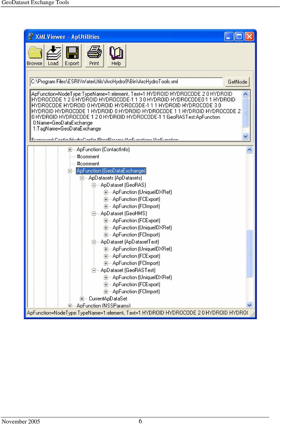
5 Browse to the bin folder under the Arc Hydro installation directory (defaults to C:\Program Files\ESRI\WaterUtils\ArcHydro9\Bin) and select the file ApGeoDataEx9.dll. Click Open. The Added Objects window is displayed. Click OK. The GeoDataset Exchange Tools toolbar should now be listed under Toolbars. Check the toolbar and click Close. The GeoDataset Exchange Tools toolbar is now visible in ArcMap. 3 Toolbar Description The GeoDataset Exchange Tools contains one function and two menus: Select GeoDataset function: Allows selecting the current configuration for the data exchange tools. GeoData Exchange menu: Contains the tools performing the data exchanges, including unique identifiers management. ApUtilities menu: Contains utilities functions. Also available in the Arc Hydro Tools toolbar. The function XML Manager allows editing the XML associated to the map document and updating the functions configurations. The GeoDataset Exchange Tools are configured using the file ArcHydroTools.xml. The data exchange configurations are stored under the ApFunctions node in this XML file. ArcHydroTools.xml is automatically loaded when an ArcMap document is opened. The XML file can be accessed by using the function ApUtilities>XML Manager, which is a part of both the Arc Hydro Tools and the GeoDataset Exchange Tools toolbar. The XML Manager provides an environment for editing the application configuration. When the ArcMap document is saved, changes to configuration are saved with that ArcMap document. Configuration changes are lost when exiting ArcMap without saving the document, unless the configuration has been previously explicitly exported to an XML file. November

6 Note To update the configuration for all new map documents, you need to update the ArcHydroTools.xml file located in the Arc Hydro install/bin directory. This is the file that is loaded with the new mxds. Updates performed in a map document only apply to that map document. The application XMLViewEdit.exe is the executable for the XML Viewer that allows editing the XML file on disk with the same editor as the one accessible with the ApUtilities>XML Manager function. XMLViewEdit.exe is installed in the ArcHydro9\bin directory. The GeoDataset Exchange Tools rely on the following ApFunction nodes located under the parent node FrameworkConfig/HydroConfig/ProgParams/ApFunctions: GeoDataExchange FCExport FCImport UniqueIDXRef November

7 3.1 Select GeoDataset The Select GeoDataset function allows selecting one of the exchange configuration predefined in the XML associated to the map document. The function reads the configurations from the node FrameworkConfig/HydroConfig/ProgParamsApFunctions/ApFunction(GeoDataExchange). This node is designed as the repository for configurations of multiple GeoDatasets, represented as ApDataset in the XML. Each ApDataset appearing in this node has three child nodes: FCExport, FCImport, and UniqueIDXRef. These three nodes store the configuration for the functions Import Feature Classes (FCImport), Export Feature Classes (ExportFC), Update UniqueID Reference Table (UniqueIDXRef) and Update UniqueID (UniqueIDXRef) for a specific GeoDataset.. The GeoDataExchange configuration has the following structure and parameters: ApDatasets collection of ApDataset o ApDataset configurations packaged for a specific data exchange operation FCExport Configuration node for data export function. FCImport Configuration node for data import function. UniqueIDXRef Configuration node for UniqueID cross reference table and UniqueID update functions. The Select GeoDataset function overwrites the three ApFunction nodes (FCExport, FCImport and UniqueIDXRef) located under the node ApFunctions with the three ApFunctions nodes defined for the selected configuration (e.g. GeoRASTest). Warning Always configure the nodes under the node ApFunction(GeoDataExchange) to avoid losing modification when switching configuration (and overwriting the ApFunctions/ApFunction node for FCExport, FCImport and UniqueIDXRef). Note The node ApFunction(GeoDataExchange)/CurrentApDataSet stores the name of the currently selected configuration. November

8 November
9 3.2 GeoData Exchange The GeoData Exchange menu contains the functions performing the imports/exports and unique identifiers management. The menu is subdivided into two submenus: - Batch Data Exchange - Step By Step Data Exchange Batch Data Exchange The Export GeoDataset function combines the functions Export Feature Classes, Update UniqueID Reference Table and Update UniqueID. The Import GeoDataset function combines the functions Import Feature Classes, Update UniqueID Reference Table and Update UniqueID Step By Step Data Exchange The Step By Step Data Exchange menu contains the individual Import/Export and Unique Identifier management functions Export Feature Classes The Export Feature Classes function allows exporting layers from a source into a target geodatabase. The function reads the configuration from the node ApFunctions/ApFunction(FCExport). This node allows specifying the default source and target workspaces for the export function and the feature classes to transfer, as well as defining the parameters for the transfer (i.e. Fields to exclude, Key fields, etc.). November

10 The function exports features and records from the source database into the target database based on the current configuration. Unless otherwise specified, all fields from a source table will be copied with the same structure into a target table. The three following fields will be appended to the target table: UniqueIDOrg: UniqueID of the record in the source database. The name of this field is constructed by appending the suffice Org to the name of the UniqueID field in the source geodatabase (e.g. HydroID in source triggers the creation of the field HydroIDOrg in the target table). OIDOrg: OID of the record in the source database. IsDone: Indicates the status of the record. This field is updated with one of the following values after running the Export Feature Classes function: o 1: Record created/updated in the target table or existing record not updated having ISDONE=1 in the original record stored in the target table. o 2: Existing record not updated/exported having ISDONE not in (1, 4, 8) in the existing record in the target table. o 4: Existing record not updated having ISDONE=4 in the existing record in the target table. o 8: Existing record not updated having ISDONE=8 in the existing record in the target table Import Feature Classes The Import Feature Classes function allows importing data from a source into a target geodatabase. The function reads the configuration from the node ApFunction(FCImport). This node is similar to the FCExport node, and provides parameters that allow specifying the layers/tables that need to be imported. The function imports features and records from the source database into the target database based on the current configuration. Unless otherwise specified, all fields from a source table will be copied with the same structure into a target table. The three following fields will be appended to the target table: UniqueIDOrg: UniqueID of the record in the source database. The name of this field is constructed by appending the suffice Org to the name of the UniqueID field in the source geodatabase (e.g. HydroID in source triggers the creation of the field HydroIDOrg in the target table). OIDOrg: OID of the record in the source database. IsDone: Indicates the status of the record. This field is updated with one of the following values after running the Import Feature Classes function: o 4: Existing record not updated having ISDONE=4 in the existing record in the target table. o 8: Existing record not updated having ISDONE=8 in the existing record in the target table. o 16: Record created/updated in the target table or existing record not updated having ISDONE=1 in the original record stored in the target table. o 32: Existing record not updated/exported having ISDONE not in (4, 8,16) in the existing record in the target table. November
.")
11 Update UniqueID Reference Table This function builds a cross-reference table in the target database that stores, for each exported record, the original unique identifier in the source database and the associated new unique identifier in the target geodatabase (e.g. HydroID-HydroIDOrg). The function processes only the records having ISDONE in (1,4,16). The ApFunction(UniqueIDXRef) node stores the configuration for both UniqueID cross reference table generation and UniqueID update functions. This node allows selecting the current workspace, and specifying which layers and fields to look into when extracting new and original UniqueID values. The function Update UniqueID Reference Table updates the field ISDONE with the value 4 in each record that contains the fields HYDROID and HYDROIDORG, whose values are copied to the crossreference table Update UniqueID The function Update UniqueID updates the related identifiers (e.g. DRAINID, JUNCTIONID) with the new UniqueID value associated to the original UniqueID value stored in these fields. The function extracts the new values from the cross-reference table generated using the function Update UniqueID Reference Table. The function updates only the records that: Contain the fields HYDROID/HYDROIDORG fields and have ISDONE=4. Do not contain the fields HYDROID/HYDROIDORG and have ISDONE=1 or 4 or 16. The configuration associated to the Update UniqueID function is stored under the node ApFunctions/ApFunction(UniqueIDXRef) in the XML. Note that this node also stores the configuration for the Update UniqueID Reference Table function. The parameters (workspace, UniqueID field, etc.) that are defined under this node are described in section 4.2 UniqueID Management Configuration. The Update UniqueID function populates the field ISDONE with the value 8 for each processed record (i.e. each record where a related identifier is updated). November

12 4 XML Configuration 4.1 Export/Import Functions Configuration The function Export Feature Classes reads its configuration from the node ApFunction(FCExport), whereas the function Import Feature Classes reads it from the node ApFunction(FCImport). Both configurations contain the same parameters that are detailed in the two tables below. November
.")
13 Export/Import Functions Configuration Parameter Name Description Default source workspace. Defined as connection string to source data workspace. This workspace can be an ArcSDE geodatabase or a personal geodatabase. Connection string for an ArcSDE workspace is of the form FromWorkspace Connection to server.sde. Note that the Import and Export functions will prompt for this workspace, which will default to the location set in the XML. Default target database. Defined as connection string to target data workspace. This workspace can be an ArcSDE ToWorkspace or personal geodatabase. The Export/Import functions will prompt for this workspace, which will default to the location set in the XML. Indicate the behavior of the Export/Import functions when the target layer/table already exists: 0: Append transferred records to target attributes table. 1: Delete all records from target table then append transferred records (For export only. Not allowed for import). 2: Overwrite records that already exist in target table (based on key field) and append records that do not RemoveRecs already exist in target table. 3: Do not overwrite records that already exist in target table (based on key field). Append records that do not already exist in target table. 4: Delete from target table records that are transferred and are already in target table (based on key field). Option available for Export only. Indicate whether the values in the source UniqueID (HydroID) field should be copied to the target UniqueID field: 0: Do not copy (Default setting). 1: Copy the unique id field values. Notes: 1. If the UniqueID field is set to HydroID, the HydroID field will be automatically populated with new values when CopyUniqueID CopyUniqueID=0 as the HydroID Manager is enabled by default. The HydroID Manager can be enabled/disabled by using the function ApUtilities>Enable/Disable HydroID Manager. In that case the HydroIDs will be left Null. Where TrnLayers 2. When selecting CopyUniqueID=1, the function automatically disables the HydroID Manager so that the HydroIDs are copied from the source, and not regenerated. The function reenables the HydroID Manager at the end of the operation. Where clause used to filter the records to export/import. Defined as a string (e.g. OID<10). The where clause is optional and may be left blank. When defined, it is used to filter each layer that does not have a specific where clause defined at the layer level. TrnLayers is the parent node for all TrnLayer child nodes, i.e. the layers, whose data are to be copied into target database. Attributes of TrnLayers are: TagName: TrnLayers Name: TrnLayers Headers: Optional. List of headers used to build the name of source/target layer. Comma-delimited. See node TrnLayers/TrnLayer for additional information on the Headers parameter. November

14 Parameter Name TrnLayers/TrnLayer Description Each TrnLayer node defines one layer or table to copy. TrnLayer has the following attributes: TagName: Layer tagname. Name: Layer name. FromLayer: Layer name in source database. ToLayer: Layer name in target database. CopyShape - Indicate whether the shape of a feature should be copied when updating an existing feature in the target database. By default, the shape field will be updated. - 0: Do not update shape. - 1: Update shape. Where: Where clause defining records to copy specific to layer. Overwrite where clause defined at function level (e.g. OID<10). OperationType: Indicate the behavior of the Export/Import functions when the target layer/table already exists. If not set, defaults to the RemoveRecs parameter defined at the function level: - 0: Append all transferred records to target attributes table. - 1: Delete all records in target table then append all transferred records. - 2: Overwrite retransferred records in target table and append records transferred for the first time. - 3: Do not overwrite retransferred records in target table. Only append new records not previously transferred. - 4: Remove retransferred record from target table (export only). HasHeader: Indicates whether the layer names are defined by concatenating a header to the Name specified as attribute. - 0: Does not have header - 1: Has header. Add2Map: Optional. Indicates whether the input and/or output layers will be added into the Table of Contents of ArcMap. Layers are added turned off by default: - 0: Add neither input nor output layers - 1: Add input layers only. - 2: Add output layers only. - 3: Add both input and output layers. This is the default setting. Notes: A header is a prefix appended to the layer name. For example, there could be a watershed, river, drainage point feature classes defined for each county in a state, with the naming convention: CountyNameRiver for the River feature classes CountyNameWatershed for the Watershed feature classes CountyNameDrainagePoint for the DrainagePoint feature classes November
.")
15 Instead of having to configure the River, Watershed and DrainagePoint layers for each county, the header parameter allows setting them only once. The possible headers (i.e. list of county names in this example) are defined by using the Attribute Headers of the TrnLayers node as a comma delimited list (e.g. County1, County2, etc). UniqueIDField ApFields(ExcludedFields) ApFields(RemovedFields) TrnField(KeyField) The Header is not defined for the UniqueID functions. Each layer will need to be listed when configuring these functions. Name of the UniqueID field in the source and target geodatabase. This field defaults to HYDROID if not set in the XML. A field named by appending the suffix ORG to the specified UniqueID field (e.g. HYDROIDORG) is created in the target workspace this field stores the corresponding UniqueID from the source database. Note: This parameter needs to match the name, not the alias, of the field. List of fields created in the target geodatabase but not populated/updated during the export/import (e.g. the values are not copied from the source to the target geodatabase). This list of fields applies to each layer that does not have its specific ExcludedFields parameter defined at the layer level. Each field is defined as an ApField node with the Name attribute storing the name (not the alias) of the field to remove. List of fields from the source geodatabase that will not be created in the target geodatabase. This list of fields applies to each layer that does not have its specific RemovedFields parameter defined at the layer level. Each field is defined as an ApField node with the Name attribute storing the name (not the alias) of the field to remove. Key field defines the fields used to uniquely identify a feature or record in the source and target geodatabase. It has 4 attributes: TagName: Must be set to KeyField Name: For display purpose only. Given as FromField-ToField (e.g. HYDROCODE-HYDROCODE) FromField: Field storing the global unique identifier in the source geodatabase (e.g. HYDROCODE) ToField: Field in the target geodatabase storing the global unique identifier from the source geodatabase (e.g. HYDROCODE) Notes 1. Whenever available use the a global unique identifier field as key field, not HydroID or OID. 2. TrnLayer(KeyField) defined at the TrnLayer level overwrites the setting set at the function level. Add2Map 3. The KeyField.FromField of ExportFC becomes KeyField.ToField of ImportFC function, and vice versa. Optional. Indicates whether the input and/or output layers will be added into the Table of Contents of ArcMap. All Layers are added turned off by default (Add2Map=3): 0: Add neither input nor output layers 1: Add input layers only. 2: Add output layers only. 3: Add both input and output layer. This is the default setting. November
 is created in the target workspace this field stores the corresponding UniqueID from the source database.")
16 Configuration of the child nodes of the TrnLayer node Parameter Name Description Define transfer fields that do not have the same name in the source and the target feature layer/table. TrnField are optional. By default, all the fields in the source table will be copied with the same field definition. TrnFields contains a list of TrnField, which has the following structure. TrnFields/TrnField TagName: Field tag name. Name: Field name. FromField: Name of source field. ToField: Name of target field. ApFields (ExcludedFields) List of fields, whose values will not be copied from source to target. This is an optional attribute. When this attribute is defined, it overwrites the same field on the function level. ApFields (RemoveFields) List of fields, whose structure will not be copied from source to target. This is an optional attribute. When this field is defined, it overwrites the same field on the function level. TrnField (KeyField) KeyField specific to the layer (e.g. LUCODE-LUCODE). This field is optional. When this field is defined, it overwrites the TrnField(KeyField) defined at the function level. November
 List of fields, whose values will not be copied from source to target. This is an optional attribute.")
17 4.2 UniqueID Management Functions Configuration The ApFunction(UniqueIDXRef) node stores the configuration for both the Update UniqueID Reference Table and Update UniqueID functions. The cross-reference table is a lookup table between original UniqueIDs (HydroIDs) and current UniqueIDs (HydroIDs). The cross-reference table is named by appending the suffix XREF to the name of the UniqueID field set in the XML (e.g. HydroIDXRef for HydroID). The reference table contains two fields named after the specified UniqueID field. For example, for HydroID, the two fields will be named HydroIDOrg and HydroID, with the HydroID field storing the unique identifiers used in the target database and the HydroIDOrg field the unique identifiers used in the source database. The parameters used to configure the UniqueIDs Management functions are described in the table below. ApFunction(UniqueIDXRef) Configuration Parameter Name Description Workspace Connection string to the workspace containing the data to process. This workspace will store both the UniqueIDXRef table and the layers that need to have their UniqueIDs updated. Notes: 1. The user will be prompted for the workspace when running the functions Update UniqueID Reference Table and Update UniqueID. The workspace will default to the value set in the XML. 2. After using an import/export function, the workspace is automatically updated in the XML with the target workspace selected for the import/export operation. RemoveRecs Indicate the behavior if records exist in the cross-reference table (HydroIDXRef): 0: Append records to reference table (i.e. may end-up with duplicate HYDROID-HYDROIDORG combination records in the table). 1: Remove all records from table, then append all records. 2: Verify record existence first. Append only record having a HYDROID-HYDROIDORG combination that is not already in the reference table. UniqueIDField Name of field storing the UniqueID (e.g. HydroID) in the source and target geodatabase. The UniqueID of the source table is saved in the target table in the field named by appending ORG to the name of the UniqueID field. For example, if the UniqueIDField is set to HYDROID, the HYDROID field in the target geodatabase stores the unique identifier in the target geodatabase while the field HYDROIDORG stores the original HYDROID of the record in the source geodatabase. ApFields List of fields storing a related UniqueID that need to be updated to match the updated UniqueIDs. For example, in an Arc Hydro geodatabase, the fields NextDownID, DrainID, JunctionID that store the HydroID of the next down feature, related drainage area and related junction feature respectively need to be updated after export/import to match the new HydroID of the exported/imported feature. If this node is not defined, the fields DrainID, NextDownID, JunctionID and FeatureID will be used by default. ApLayers List of layers: From which to retrieve the UniqueID/UniqueIDORG combination to store in the UniqueIDXRef table Which have related identifier field(s) to update. November

18 5 Example of Data Exchange Tools Configuration The sample data used in the following sections is a personal geodatabase called GeoRas.mdb. It can be used as is or can be loaded into an ArcSDE geodatabase as needed. The data can be obtained by downloading the file ArcHydro/Data/DataExchangeData.zip from the ESRI Water Utilities ftp site (ftp.esri.com, login:riverhydraulics, password: river.1114). 5.1 Export Data into Target GeoDatabase 1. Open a new ArcMap document. Make sure the toolbar GeoDataset Exchange Tools is displayed. 2. In ArcMap, click on Select GeoDataset and choose GeoRASTest as your current configuration. Click Yes when prompted to confirm the selection. The Select GeoDataset function overwrites the three nodes ApFunction(FCExport), ApFunction(FCImport) and ApFunction(UniqueIDXRef) defined under the node ApFunctions (and used by the import/export and UniqueID management functions) with the same three nodes defined under the node ApFunctions/ApFunction(GeoDataExchange)/ApDatasets/ApDataset(GeoRASTest). 3. Select GeoDataExchange>Step By Step Data Exchange>Export Feature Classes. The function displays a window showing the default source and target workspaces set in the XML. The workspaces may be modified if necessary. 4. Modify the source/target workspace as needed. The workspace may be either a local or an ArcSDE geodatabase. The source workspace must exist. The target workspace will be created if it does not already exist. Click OK after selecting the workspaces. The Export Feature Classes function copies the feature classes configured in the FCExport node of the active configuration from the source workspace into the target workspace. The source and target feature classes are automatically added into the table of contents of ArcMap. This is the default setting that may be modified by updating the parameter Add2Map in the XML. 5. In ArcMap, open the Attributes table of the layer XSCutLines3D stored in the target workspace. November

19 Note that the fields OIDORG, HYDROIDORG and ISDONE have been appended to the table. The HYDROIDORG and OIDORG fields store respectively the original HydroID and OID from the source workspace. The field ISDONE stores the status of the record after export. It is set to 1 after exporting a record. The field XS2DID stores the HydroID of the associated XSCutLines feature. 6. Write down the values currently stored in this field (14 to 37 for sample data). 7. Open the Attributes table of Manning. Note that only two fields have been added to this table, OIDORG and ISDONE. The field HYDROIDORG was not added because there is no HydroID field in the source table. Write down the values of XS2DID (14 to 37 for the sample dataset). The field ISDONE contains the value 1 that characterizes newly exported features. 8. In ArcMap, click GeoDataExchange>Step By Step Data Exchange > Update UniqueID Reference Table. The Select Workspace window is displayed. This workspace is set by default to the target workspace specified when running the function Export Feature Classes. 9. Click OK. The table HYDROIDXREF is added into the table of contents of ArcMap. 10. Open the table HYDROIDXREF and review its records. This table stores the relationship between newly assigned HydroID and original HydroID (HYDROIDORG). November
.")
20 11. Open the Attributes table of Manning and of XSCutLines3D. The value of the field ISDONE is still 1 in the Attributes table of Manning, but has been updated to 4 in the Attributes table of XSCutLines3D. The value 4 indicates that the record contains the fields HYDROID/HYDROIDORG (when UniqueID is set to HydroID) and that the values from these fields have been stored in the HYDROIDXREF table. 12. In ArcMap, click GeoDataExchange>Step By Step Data Exchange > Update UniqueID. The Select Workspace window is displayed. This workspace is set by default to the workspace selected when running the function Update UniqueID Reference Table. 13. Click OK. 14. Open the attributes table of Manning and XSCutLines3D. The values in the field XS2DID in both tables have been updated to reflect the newly assigned HydroID in the target database, so that data integrity between Manning/XSCutLines3D and other related feature classes (e.g. XSCutLines) is maintained. The field ISDONE is updated to 8 in the records that have been processed. November

21 The function GeoDataExchange>Batch Data Exchange>Export GeoDataset could have been used instead of the combination of the 3 functions Export Feature Classes/Update UniqueID Reference Table/Update UniqueID. 5.2 Export Selected Features into an Existing Personal GeoDatabase The Export Feature Classes function exports only the selected features in the source feature classes having a selection set. If there is no selected set, all features from the feature class will be exported. 1. Add the layer XSCutLines from your source geodatabase to ArcMap if necessary. 2. Click Editor>Start editing and set the layer XSCutlines as target. Create two new XSCutlines line features and save your edits. 3. Select the two newly created features. 4. Select ApUtilities>XML Manager. In the XML Viewer, navigate to the node FrameworkConfig/HydroConfig/ ProgParams/ApFunctions/ ApFunction(GeoDataExchange)/ApDatasets/ ApDataset (GeoRASTest)/ApFunction(FCExport). 5. Select the node RemovesRecs. Right-click the node and select EditText to open the Edit window. Make sure the node has a value of 2 this means that all existing records in the target database will be overwritten and that new records will be appended. 6. In ArcMap, click on Select GeoDataset and reselect GeoRASTest as your current configuration if you have edited the XML. The function will copy the modifications to the active configuration node read by the export function. 7. Select GeoDataExchange>Batch Data Exchange>Export GeoDataset. 8. Select the source workspace by browsing to its location or typing the ArcSDE connection string or directory path to the geodatabase containing the source data. 9. Enter a new target workspace different from the workspace created in section 5.1. Click OK. November
22 The function performs consecutively the steps Export Feature Classes, Update UniqueID Reference Table and Update UniqueID. The function indicates that 2 records with a null identifier were not exported. This is because the Key field in the source database (HydroCode) is empty for the two new records. 10. Open the Attributes table of XSCutLines in the target geodatabase. The table is empty since only two features were selected, and these features were not exported because they have an empty (Null) key field. 11. Click Editor>Start Editing and select the source geodatabase as editing workspace. Populate the HydroCode field for the new features with the concatenation of XS and the HydroID. Stop editing and save the edits. 12. Reselect the 2 new features and click GeoData Exchange>Batch Data Exchange>Export GeoDataset. Click OK in the Select Workspaces window. Only the two newly added cross section features have been copied to the target cross-section feature class. 5.3 Import new feature class 1. Start ArcCatalog and create a new polygon feature class named FloodPlain in the target personal geodatabase created in section 5.1 (Note: You need to close ArcMap). Add the attribute FLOODCODE as text field of length 20. This field will be used as the key field that uniquely identifies FloodPlain features. 2. Browse the source workspace for the export and double-check that the FloodPlain feature class does not exist in the source database. 3. Start ArcMap and add the FloodPlain feature class. Create a new polygon feature in the FloodPlain feature class. Populate the field FLOODCODE and save the edits. 4. Select ApUtilities>XML Manager. Navigate to the node FrameworkConfig/HydroConfig/ ProgParams/ApFunctions/ ApFunction(GeoDataExchange)/ApDatasets/ ApDataset(GeoRASTest)/ApFunction(FCImport). Expand the node Trnlayers and make sure TrnLayer(FloodPlain) is listed. 5. Click on Select GeoDataset and select GeoRASTest as your current configuration if needed. 6. Click GeoDataExchange>Batch Data Exchange>Import GeoDataset. The Select Workspaces window is displayed. November
23 7. Select as Source Workspace the geodatabase containing the data previously exported, and as target the geodatabase the data was exported from. Click OK. The feature class FloodPlain is copied into the original personal geodatabase GeoRas.mdb. 5.4 Edit Configuration XML to Manage Data Exchange Add a new feature class to export. 1. Select ApUtilities>XML Manager to open the XML Viewer. Navigate to FrameworkConfig/HydroConfig/ProgParams/ApFunctions/ApFunction(GeoDataExchange)/ApDatasets/ApD ataset(georastest)/ ApFunction(FCExport)/TrnLayers. 2. Select the node TrnLayer(XSCutLines). Right-click this node and select Copy. 3. Select the node TrnLayers, right-click and select Paste. 4. Select the new copied node TrnLayer(XSCutLines). Right-click this node and select EditAttributes to open the Attribute Editor window. Change all the values from XSCutLines to Levees3D and click OK. The layer Levees3D contains the HydroID field as well as the field Lev2DID that stores the HydroID of the related Levee feature. This layer needs to be processed with the UniqueID management functions, and hence added to the XML node read by these functions. 5. Navigate to the node FrameworkConfig/HydroConfig/ProgParams/ApFunctions/ApFunction(GeoDataExchange)/ApDatasets/ApD ataset(georastest)/ ApFunction(UniqueIDXRef)/ApLayers. 6. Right-click the node ApLayer(Levees), and select Copy. 7. Right-click the node ApLayers one level above and select Paste. 8. Right-click the new ApLayer(Levees) node and select EditAttributes. Change the name, tag name and alias to Levees3D (Note: only the name is used.). 9. Browse to the node FrameworkConfig/HydroConfig/ProgParams/ApFunctions/ApFunction(GeoDataExchange)/ApDatasets/ApD ataset(georastest)/ ApFunction(UniqueIDXRef)/ApFields that lists the fields storing unique identifiers November
24 that need to be updated with the Update UniqueID function. Check that ApField(Lev2D2D) is defined. Click OK and close the XML Viewer. 10. In ArcMap, click on Select GeoDataset and select GeoRASTest as your current configuration to copy the modifications in the XML. 11. Select GeoDataExchange>Batch Data Exchange>Export GeoDataset. 12. Reset the workspaces to the correct source and target geodatabases and click OK. The layer Levees3D is exported into the target geodatabase and added into the Table of Contents of ArcMap. The Lev2DID field is updated with the new HydroID used in the target database for the related Levee feature Add a new export filter 1. Open XML Manager and navigate to FrameworkConfig/HydroConfig/ ProgParams/ApFunctions/ ApFunction(GeoDataExchange)/ApDatasets/ ApDataset (GeoRASTest)/ApFunction(FCExport). 2. Select the node Where, right-click and select EditText to open the Edit window. Type in the value field OID< In ArcMap, reselect GeoRASTest as the current dataset and perform a data export to a new target geodatabase. Only features with OID<10 are copied to the target Geodatabase. Note: The Where clause may also be set at the layer level Exclude a field structure from the target database 1. Open XML Manager and Navigate to FrameworkConfig/HydroConfig/ProgParams/ApFunctions/ApFunction(GeoDataExchange)/ApDatasets/ApD ataset(georastest)/apfunction(fcexport)/apfields(excludedfields). Right-click the child node ApField(HYDROID,HydroID) and select copy. 2. Navigate to the node ApFields(RemoveFields) located at the same level as ApFields(ExcludedFields), right-click and select Paste. 3. Right-click the new ApField node and select EditAttributes. Set the values of Name to RiverCode. Note that other attributes (e.g. Alias) that may be defined for the ApField are November
25 ignored. Only the Name is used to define the field(s) that will not be created in the target geodatabase. Other attributes may be left as is, updated or deleted. 4. Click OK and close the XML Viewer. 5. Click Select GeoDataset and reselect the GeoRASTest configuration to copy the previous modification. 6. Select GeoDataExchange>Step By Step Data Exchange>Export Feature Class. Set the source and a new target workspace and click OK. 7. Once the export process is complete, open the Attributes tables of River and XSCutLines feature class in the source and target geodatabase. The field River is present in the tables in the source but not in the target geodatabase. Note: River is the field alias, whereas RiverCode is the field name. The function uses the name to identify the field to remove. The alias is not used Set field that should not be populated/updated The node ApFields(ExcludedFields) is used to define the field that will be created in the target geodatabase, but whose values will not transferred to the target geodatabase. This may be used after a first export to specify the fields that should not be updated. 1. Open XML Manager and navigate to the node FrameworkConfig/HydroConfig/ProgParams/ApFunctions/ApFunction(GeoDataExchange)/ApDatasets/ApD ataset(georastest)/apfunction(fcexport)/apfields(excludedfields). Note that ApField(HYDROID, HydroID) is listed. This is because the HydroIDs are not copied but are recreated in the target geodatabase. 2. Copy the node ApField(RiverCode) from ApFields(RemoveFields) to ApFields(ExcludedFields). 3. Delete the node ApField(RiverCode) under ApFields(RemoveFields) and close the XML Viewer. 4. Click Select GeoDataset and reselect the GeoRASTest configuration. November
26 5. Select GeoDataset>Step By Step Data Exchange>Export Feature Class. Select the source workspace and a new target geodatabase. Click OK. 6. Open the Attributes tables of River and XSCutLines in the source and target geodatabase The values of the HydroID field are different in the source and target geodatabase the values were not copied but regenerated since the HydroID is the unique identifier in the geodatabase. Source table Target table 5.5 Define a New GeoDataset Configuration Node The following section describes the procedure to add a new Configuration node to export the data layers stored in a personal geodatabase named HMSA. November
27 1. Start a new ArcMap and save the new document as HMSA.mxd. 2. Select ApUtilities>XML Manager to open the XML Viewer. 3. Navigate to the node ApFunction(GeoDataExchange) located at FrameworkConfig/HydroConfig/ProgParams/ApFunctions/ApFunction. You are now going to make a copy of an existing ApDataset configuration and modify this configuration to support the new dataset. 4. Right-click an existing ApDataset node (e.g. GeoRasTest) defined under ApFunction(GeoDataExchange)/ApDatasets and select copy. 5. Right-click the node ApDatasets and select Paste to paste the node. 6. Right-click the new ApDataset node and select EditAttributes. Double-click on the Name and TagName to change their values to HMSA. November
28 5.5.1 Configure FCExport node for a new GeoDataset 1. Browse to the FCExport node under GeoDataExchange/ApDatasets/ApDataset(HMSA): 2. Set the FromWorkspace to the source workspace, i.e., the full path of HMSA.mdb file (e.g. C:\DataExchange\Data\HMSA.MDB). This value will be used as a default for the source workspace when running the Export function. The workspace may be modified interactively when performing an export. 3. Set the ToWorkspace to your default target workspace, e.g. C:\DataExchange\Data\HMSAOUT.MDB. This workspace may be modified when performing an export. 4. Right-click the node RemoveRecs and select EditText. Set the value to 2, which means that the export will overwrite existing record in the target geodatabase. 5. Right-click the node CopyUniqueID and select EditText. Set the value to 0. This means that the values of the UniqueID field, if not explicitly excluded from the transfer, will not be copied. Note: The values may be automatically populated with the HydroID Manager. 6. Right-click the node Where and select EditText. Make sure the value is left blank, i.e. there is no where clause set to filter the records to export. The TrnLayers node defines the list of layers to export from the source into the target geodatabase. You will configure the following 6 layers: River255, SubBasin255, ProjectPoint255, Centroid255, HMSNode255, HMSLink Delete all the TrnLayer nodes under TrnLayers node except the first one. Right-click the remaining TrnLayer (e.g. TrnLayer(River)) and select EditAttributes to open the AttributeEditor form. Set the Name and TagName to River and the FromLayer and ToLayer to River255. Click OK to close the Attribute Editor. 8. Right-click the node TrnLayer(River) and select Copy. November
29 9. Right-click the TrnLayers node and select Paste to paste the TrnLayer(River) node under the TrnLayers node. 10. Set the Name and TagName to SubBasin. Set the FromLayer, ToLayer values to SubBasin Repeat steps 7 and 8 for the remaining layers (ProjectPoint255, Centroid255, HMSNode255, HMSLink255). 12. Right-click the node UniqueIDField and select EditText. Set the value to HydroID. This is the field storing the unique identifier at the database level, not a global unique identifier. This field may have different values in the source and target geodatabase. 13. Expand the node ApFields(ExcludedFields). This node contains a list of ApField nodes that define the fields, whose values should not be transferred. Check that the ApField(HYDROID) is listed, i.e. the HydroIDs will not be copied from the source to the target (Note: This setting is redundant with the CopyUniqueID parameter set to 0). 14. Right-click the node TrnField(KeyField) and select EditAttributes. Make sure that TagName us set to KeyField, FromField to HYDROCODE and ToField to HYDROCODE. This parameter defines the key fields used in the source and target geodatabase to uniquely identify the records. The key field should store a global unique identifier (i.e. HydroCode, not HydroID which is not unique across databases). Note that the TrnField(KeyField) may also be different for each layer, since this field may not be the same for each layer. HydroCode is used as global identifier and key fields for the 6 layers to export. November
30 15. Right-click the node CopyShape and select EditText. Set the value to 1. This means that the shape field will be updated when overwriting an existing feature in the target geodatabase. 16. Check the node ApFields(RemovedFields). There are no child ApField nodes defined under this node. This means that all fields present in the source layers will also be present in the target layer Configure UniqueIDXRef node for a new GeoDataset The ApFunction(UniqueIDXRef) node allows setting up the configuration of the functions Update UniqueID Reference Table and Update UniqueID. The first function creates and populates the crossreference table that stores the UniqueID values (e.g. HydroID) from the source geodatabase with the corresponding value in the target geodatabase. The second function replaces related unique identifiers (e.g. DrainID sorting HydroID of related Drainage Area) with the corresponding values used in the target geodatabase. You first need to define the name of the UniqueIDField. This should be the same as the UniqueIDField set for the Export (i.e. HydroID). 1. Right-click on the UniqueIDField node and select EditText. Make sure the UniqueIDField is set to HYDROID and click OK. November
31 The ApLayers node holds a collection of layers, whose HydroID and HydroIDOrg values need to be added to the HydroIDXRef table and of layers containing at least one field storing a related unique identifier. Since the six layers being exported contain the HydroID field, you need to add one ApLayer definition for each of the 6 data layers exported. Note: only the Name parameter is used by the function. The other parameters (alias, shapetype) are not used. 2. Right-click on an existing ApLayer under the ApLayers node and select the EditAttributes option. Change the TagName, Name, Alias, and Desc values to River255. Note: only the Name parameter will be used by the function. All other parameters, if defined, are ignored. 3. Right-click the Aplayer you just modified and select Copy. 4. Right-click on the ApLayers node and select Paste. Repeat the operation 4 more times to paste additional Aplayers. 5. Right-click on the second ApLayer, select the EditAttributes option and change the TagName, Name, Alias, and Desc values to Subbasin Repeat step 4 for the remaining 4 layers ProjectPoint255, HMSNode255, HMSLink255, and Centroid Remove any additional ApLayer. The ApFields parameter defined under the node: FrameworkConfig/HydroConfig/ProgParams/ApFunctions/ApFunction/ApDatasets/ApDataset/ApFunction(UniqueIDX Ref )/ApFields specifies the related unique identifier fields (NextDownID, JunctionID, DrainID, FeatureID and DownElemID) that need to be updated to match the new unique identifier value. 8. Expand the ApFields node to view the related unique identifiers fields currently defined. Delete each ApField node except NextDownID, JunctionD, DrainID, FeatureID (if present) by rightclicking each node and selecting Delete. 9. Right-click the node ApField(NextDownID), and select Copy. 10. Right-click the ApFields node and select Paste. November
Working with ArcGIS Network Analyst
 Working with ArcGIS Network Analyst All rights reserved. Course version 2.0. Revised January 2007. Printed in the United States of America. The information contained in this document is the exclusive property
ESRI Systems Integration Technical Brief Identifying Firewall TCP Server Ports In a Enterprise ArcIMS Configuration
 Environmental Systems Research Institute, Inc., 380 New York St., Redlands, CA 92373-8100 USA TEL 909-793-2853 FAX 909-307-3014 ESRI Systems Integration Technical Brief Identifying Firewall TCP Server
Geodatabase Archiving: Introduction to Concepts and Capabilities
 Geodatabase Archiving: Introduction to Concepts and Capabilities Transcript Copyright 2006 ESRI All rights reserved. The information contained in this document is the exclusive property of ESRI. This work
Geographic Information Systems for Java
 An ESRI White Paper April 2002 ESRI 380 New York St., Redlands, CA 92373-8100, USA TEL 909-793-2853 FAX 909-793-5953 E-MAIL info@esri.com WEB www.esri.com Copyright 2002 ESRI All rights reserved. Printed
ArcGIS Network Analyst: Networks and Network Models
 ArcGIS Network Analyst: Networks and Network Models Transcript Copyright 2005 ESRI All rights reserved. The information contained in this document is the exclusive property of ESRI. This work is protected
ArcGIS Desktop I: Getting Started with GIS
 ArcGIS Desktop I: Getting Started with GIS All rights reserved. Course version 1.0. Revised May 2008. Printed in the United States of America. The information contained in this document is the exclusive
Five Best Practices for Maintaining an Enterprise Geodatabase
 Five Best Practices for Maintaining an Enterprise Geodatabase Transcript Copyright 2007 ESRI All rights reserved. The information contained in this document is the exclusive property of ESRI. This work
ArcGIS 1: Introduction to GIS. Student Edition
 ArcGIS 1: Introduction to GIS Student Edition Copyright 2016 Esri All rights reserved. Course version 4.0. Version release date March 2016. Printed in the United States of America. The information contained
Developing Web Apps with ArcGIS API for JavaScript TM. Student Edition
 Developing Web Apps with ArcGIS API for JavaScript TM Student Edition Copyright 2014 Esri All rights reserved. Course version 1.1. Version release date December 2014. Printed in the United States of America.
Metadata and GIS. An ESRI White Paper October 2002
 An ESRI White Paper October 2002 ESRI 380 New York St., Redlands, CA 92373-8100, USA TEL 909-793-2853 FAX 909-793-5953 E-MAIL info@esri.com WEB www.esri.com Copyright 2002 ESRI All rights reserved. Printed
Performance Tips and Tricks for ArcGIS Desktop 8.1
 Performance Tips and Tricks for ArcGIS Desktop 8.1 An ESRI Technical Paper September 2001 ESRI 380 New York St., Redlands, CA 92373-8100, USA TEL 909-793-2853 FAX 909-793-5953 E-MAIL info@esri.com WEB
ArcGIS 3: Performing Analysis. Student Edition
 ArcGIS 3: Performing Analysis Student Edition Copyright 2016 Esri All rights reserved. Course version 4.0. Version release date March 2016. Printed in the United States of America. The information contained
Business Analyst Desktop 10 Tutorial
 Business Analyst Desktop 10 Tutorial September 2010 Prepared by: Esri 380 New York Street Redlands, California 92373-8100 Copyright 2010 Esri All rights reserved. Printed in the United States of America.
System Architecture Design Strategies. Student Edition
 System Architecture Design Strategies Student Edition Copyright 2015 Esri All rights reserved. Course version 3.0. Version release date July 2015. Printed in the United States of America. The information
Administering ArcSDE Microsoft. for SQL Server
 Administering ArcSDE Microsoft for SQL Server Copyright Information Copyright 2008, 2009 ESRI All Rights Reserved. Printed in the United States of America. The information contained in this document is
Using ArcSDE With Microsoft SQL Server Desktop Engine
 Using ArcSDE With Microsoft SQL Server Desktop Engine An ESRI Technical Paper October 2002 ESRI 380 New York St., Redlands, CA 92373-8100, USA TEL 909-793-2853 FAX 909-793-5953 E-MAIL info@esri.com WEB
ArcGIS Spatial Analyst: Advanced GIS Spatial Analysis Using Raster and Vector Data
 ArcGIS Spatial Analyst: Advanced GIS Spatial Analysis Using Raster and Vector Data An ESRI White Paper December 2001 ESRI 380 New York St., Redlands, CA 92373-8100, USA TEL 909-793-2853 FAX 909-793-5953
Cartography with ArcGIS
 Cartography with ArcGIS All rights reserved. Course version 2.2. Revised September 2008. Printed in the United States of America. The information contained in this document is the exclusive property of
Geographic Information Systems: A Powerful New Tool for Fire and Emergency Services
 Geographic Information Systems: A Powerful New Tool for Fire and Emergency Services An ESRI White Paper May 2000 ESRI 380 New York St., Redlands, CA 92373-8100, USA TEL 909-793-2853 FAX 909-793-5953 E-MAIL
System Design Strategies 26th Edition
 26th Edition An ESRI Technical Reference Document August 2009 Prepared by: Dave Peters Systems Integration Environmental Systems Research Institute, Inc. 380 New York Street Redlands, California 92373-8100
Spatial Data Standards and GIS Interoperability
 An ESRI White Paper January 2003 ESRI 380 New York St., Redlands, CA 92373-8100, USA TEL 909-793-2853 FAX 909-793-5953 E-MAIL info@esri.com WEB www.esri.com Copyright 2003 ESRI All rights reserved. Printed
Improving the Insurance Claims Management Process
 Improving the Insurance Claims Management Process By Mark McCoy GIS BEST PRACTICES SERIES MARCH 2012 Table of Contents 3 How Can GIS Help the Claims Management Process? 3 About the Author 4 Integrating
System Design Strategies
 System Design Strategies An ESRI White Paper February 2003 Prepared by: Dave Peters Systems Integration Environmental Systems Research Institute, Inc. 380 New York Street Redlands, California 92373-8100
ESRI Systems Integration Technical Brief
 Environmental Systems Research Institute, Inc., 380 New York St., Redlands, CA 92373-8100 USA TEL 909-793-2853 FAX 909-307-3014 ESRI Systems Integration Technical Brief ArcSDE Geodatabase Replication Overview
GIS Technology for Disasters and Emergency Management by Russ Johnson
 GIS Technology for Disasters and Emergency Management by Russ Johnson An ESRI White Paper May 2000 ESRI 380 New York St., Redlands, CA 92373-8100, USA TEL 909-793-2853 FAX 909-793-5953 E-MAIL info@esri.com
GIS Best Practices. GIS for Customer and Market Analytics
 GIS Best Practices GIS for Customer and Market Analytics November 2007 Table of Contents What Is GIS? 1 GIS for Customer and Market Analytics 3 GIS and Web Services Help Manufacturer Find the Best Retailers
GIS for Homeland Security
 An ESRI White Paper November 2001 ESRI 380 New York St., Redlands, CA 92373-8100, USA TEL 909-793-2853 FAX 909-793-5953 E-MAIL info@esri.com WEB www.esri.com Copyright 2001 ESRI All rights reserved. Printed
mputing service ArcGIS business provides Esri technology rganization GIS in the Cloud consumers systems scale storage public end-user customers
 technology rganization resources ure s advantage privacy s a mputing Software customer platform storage Private flexible traffic alt-premise SaaS commonly Online hardware capabilities PaaS quickly ions
ArcView Tracking Analyst Extension The Solution for Temporal Analysis. An ESRI White Paper August 1998
 The Solution for Temporal Analysis An ESRI White Paper August 1998 ArcView GIS White Paper Series August 1998 Copyright 1997, 1998 Environmental Systems Research Institute, Inc. All rights reserved. Printed
What's New in Esri Business Analyst 10.3.1
 What's New in Esri Business Analyst 10.3.1 Esri 2015/2020 US Data Update Last revised July 14, 2015 Contents Welcome to Esri Business Analyst 10.3.1... 3 Overview Esri 2015/2020 US Data Update... 3 Data
Spatial Data Warehousing
 An ESRI White Paper March 1998 Copyright 1997, 1998 Environmental Systems Research Institute, Inc. All rights reserved. Printed in the United States of America. The information contained in this document
ESRI's Spatial Data Warehousing andOLAP
 Spatial Data Warehousing for Hospital Organizations An ESRI White Paper March 1998 Copyright 1997, 1998 Environmental Systems Research Institute, Inc. All rights reserved. Printed in the United States
GIS for Emergency Management
 GIS for Emergency Management An ESRI White Paper July 1999 Copyright 1999 Environmental Systems Research Institute, Inc. All rights reserved. Printed in the United States of America. The information contained
Introduction to the ArcGIS Mobile SDK
 Introduction to the ArcGIS Mobile SDK Transcript Copyright 2007 ESRI All rights reserved. The information contained in this document is the exclusive property of ESRI. This work is protected under United
ArcGIS 9. Installation Guide: Workgroup for Microsoft SQL Server Express
 ArcGIS 9 Installation Guide: Workgroup for Microsoft SQL Server Express Copyright 2006 ESRI All Rights Reserved. Printed in the United States of America. The information contained in this document is the
ArcSDE Database Servers Tutorial
 ArcGIS 9 ArcSDE Database Servers Tutorial Copyright 2004 2008 ESRI All rights reserved. Printed in the United States of America. The information contained in this document is the exclusive property of
Getting Started with ArcGIS API for Microsoft Silverlight/WPF
 Getting Started with ArcGIS API for Microsoft Silverlight/WPF Transcript Copyright 2009 ESRI All rights reserved. Printed in the United States of America. The information contained in this document is
Enterprise GIS System Architecture
 Enterprise GIS System Architecture Prepared for: Date: 9/26/2011 Prepared by: Danny Krouk Enterprise Implementation Services Team (EIST) Environmental Systems Research Institute, Inc. (ESRI) 380 New York
Animation in ArcMap Tutorial
 ArcGIS 9 Animation in ArcMap Tutorial Copyright 2005 2008 ESRI All Rights Reserved. Printed in the United States of America. The information contained in this document is the exclusive property of ESRI.
GEOMEDICINE CAN GEOGRAPHIC INFORMATION. By Bill Davenhall, Esri
 GEOMEDICINE CAN GEOGRAPHIC INFORMATION MAKE ME HE LTHY? By Bill Davenhall, Esri What Is Geomedicine? This e-book sets forth the notion that the emerging fi eld of geomedicine will produce a new type of
How To Use Gis For Real Estate
 GIS Best Practices GIS for Real Estate February 2007 Table of Contents What Is GIS? 1 GIS for Real Estate 3 Commercial Real Estate Union Pacific Railroad Locates Real Property Assets With GIS 5 Edens &
GIS Best Practices. Law Enforcement
 GIS Best Practices Law Enforcement August 2006 Table of Contents What Is GIS? 1 GIS for Law Enforcement 3 Santa Clara County, California, Develops a Regional Crime Analysis Tool 5 Web Site Coordinates
Features and Functions of ArcInfo 8
 An ESRI White Paper Features and Functions of ArcInfo 8 September 1999 ESRI 380 New York St., Redlands, CA 92373-8100, USA TEL. 909-793-2853 FAX 909-793-5953 E-MAIL info@esri.com WEB www.esri.com Copyright
ESRI Shapefile Technical Description
 An ESRI White Paper July 1998 Copyright 1997, 1998 Environmental Systems Research Institute, Inc. All rights reserved. Printed in the United States of America. The information contained in this document
ArcGIS 9. Installation Guide: ArcSDE for SQL Server Express licensed through ArcGIS Server Workgroup
 ArcGIS 9 Installation Guide: ArcSDE for SQL Server Express licensed through ArcGIS Server Workgroup Copyright 2006-2008 ESRI All Rights Reserved. Printed in the United States of America. The information
Using Microsoft SQL Server Snapshot Replication With ArcSDE Data
 Using Microsoft SQL Server Snapshot Replication With ArcSDE Data An ESRI Technical Paper May 2004 ESRI 380 New York St., Redlands, CA 92373-8100, USA TEL 909-793-2853 FAX 909-793-5953 E-MAIL info@esri.com
ArcGIS. Image Server tutorial
 ArcGIS 9 ArcGIS Image Server tutorial Copyright 2006, 2007, and 2008 Zanja Technologies, Inc. All rights reserved. The information contained in this work is the property of Zanja Technologies, Inc., under
GIS Best Practices. GIS for Retail Business
 GIS Best Practices GIS for Retail Business February 2007 Table of Contents What Is GIS? 1 GIS for Retail Business 3 Site Selection Approaches 5 Food Producers Go to Market With GIS 11 Parameter Estimation
Esri News for Electric & Gas Utilities 2014
 Esri News for Electric & Gas Utilities 2014 Solar Power for the German Grid Lechwerke Improves Customer Service Lechwerke (LEW), a major, regional electricity supplier in southern Germany, provides 500,000
ArcGIS Online in Education
 September 2013 ArcGIS Online in Education Success Stories from Early Adopters Table of Contents 3 Introduction 5 Introducing Geospatial Concepts to General Education Students 8 Fostering New Pathways
An ESRI Technical Paper July 2008 ArcGIS 9.3 Enterprise Deployment
 An ESRI Technical Paper July 2008 ArcGIS 9.3 Enterprise Deployment ESRI 380 New York St., Redlands, CA 92373-8100 USA TEL 909-793-2853 FAX 909-793-5953 E-MAIL info@esri.com WEB www.esri.com Copyright 2008
Configuring a Distributed Installation of ArcGIS Server (Windows)
") Configuring a Distributed Installation of ArcGIS Server (Windows) An ESRI Technical Paper April 2006 ESRI 380 New York St., Redlands, CA 92373-8100, USA TEL 909-793-2853 FAX 909-793-5953 E-MAIL info@esri.com
Configuring a Distributed Installation of ArcGIS Server (Windows) An ESRI Technical Paper April 2006 ESRI 380 New York St., Redlands, CA 92373-8100, USA TEL 909-793-2853 FAX 909-793-5953 E-MAIL info@esri.com
GIS Best Practices. Mining
 GIS Best Practices Mining August 2006 Table of Contents What Is GIS? 1 GIS for Mining 3 British Columbia Administers Mining Titles Online 4 Mining Gold in Montana With GIS and Underground 9 Modeling Stockton-on-Tees,
An Esri Technical Paper June 2010 ArcGIS 10 Enterprise Deployment
 An Esri Technical Paper June 2010 ArcGIS 10 Enterprise Deployment Esri 380 New York St., Redlands, CA 92373-8100 USA TEL 909-793-2853 FAX 909-793-5953 E-MAIL info@esri.com WEB www.esri.com Copyright 2010
Database Servers Tutorial
 Copyright 1995-2010 Esri All rights reserved. Table of Contents A quick tour of the database servers tutorial........................ 3 Exercise 1: Add a database server to the Catalog tree and create
Working with the Geodatabase Using SQL
 An ESRI Technical Paper February 2004 This technical paper is aimed primarily at GIS managers and data administrators who are responsible for the installation, design, and day-to-day management of a geodatabase.
An Esri White Paper February 2011 Best Practices for Storing the ArcGIS Data Reviewer Workspace in an Enterprise Geodatabase for Oracle
 An Esri White Paper February 2011 Best Practices for Storing the ArcGIS Data Reviewer Workspace in an Enterprise Geodatabase for Oracle Esri, 380 New York St., Redlands, CA 92373-8100 USA TEL 909-793-2853
The Role of GIS Technology in Sustaining the Built Environment. By Patrick Wallis, AICP, LEED AP, GISP
 The Role of GIS Technology in Sustaining the Built Environment By Patrick Wallis, AICP, LEED AP, GISP 1 Table of Contents An Introduction 3 Executive Summary 4 A Sustainability Problem 7 A Communication
An Esri White Paper August 2010 Product Library in Esri Aeronautical Solution: Enabling Seamless Product, Data, and Document Management
 An Esri White Paper August 2010 Product Library in Esri Aeronautical Solution: Enabling Seamless Product, Data, and Document Management Esri, 380 New York St., Redlands, CA 92373-8100 USA TEL 909-793-2853
ArcView Tracking Analyst: Complete Tracking Solutions
 ArcView Tracking Analyst: Complete Tracking Solutions An ESRI White Paper May 1999 Copyright 1999 Environmental Systems Research Institute, Inc. All rights reserved. Printed in the United States of America.
Esri News for Telecommunications Spring 2014
 Esri News for Telecommunications Spring 2014 Poland Secures Public Funding for Broadband Infrastructure By Magdalena Jablonska, Suntech S.A. Universal broadband Internet access is often the determining
Spatial Database Support
 Page 1 of 11 Spatial Database Support Global Mapper can import vector data from and export vector data to the following spatial databases: Esri ArcSDE Geodatabase Esri File Geodatabase Esri Personal Geodatabases
GIS Best Practices. Using GIS with GPS
 GIS Best Practices Using GIS with GPS March 2009 Table of Contents What Is GIS? 1 GPS-GAP Changes the Way We View the Earth 3 GIS and GPS Integration Eases Public Road Inventory 9 Dominion and Verizon
An Esri White Paper February 2011 Best Practices for Storing the ArcGIS Data Reviewer Workspace in an Enterprise Geodatabase for SQL Server
 An Esri White Paper February 2011 Best Practices for Storing the ArcGIS Data Reviewer Workspace in an Enterprise Geodatabase for SQL Server Esri, 380 New York St., Redlands, CA 92373-8100 USA TEL 909-793-2853
January 2014. India: A Vision for National GIS
 January 2014 India: A Vision for National GIS Table of Contents 3 Introduction 4 India's Geospatial Success 6 A Vision for National GIS 15 A National GIS Benefiting India 16 An Interview with Mukund Rao
Government 1009: Advanced Geographical Information Systems Workshop. LAB EXERCISE 3b: Network
 Government 1009: Advanced Geographical Information Systems Workshop LAB EXERCISE 3b: Network Objective: Using the Network Analyst in ArcGIS Implementing a network functionality as a model In this exercise,
An Esri White Paper October 2010 Esri Production Mapping Product Library: Spatially Enabled Document Management System
 An Esri White Paper October 2010 Esri Production Mapping Product Library: Spatially Enabled Document Management System Esri, 380 New York St., Redlands, CA 92373-8100 USA TEL 909-793-2853 FAX 909-793-5953
Getting Started with ArcGIS
 Getting Started with ArcGIS Bob Booth and Andy Mitchell GIS by ESRI Copyright 1999 2001 ESRI. All rights reserved. Printed in the United States of America. The information contained in this document is
How To Build Gis Applications With An Arcgis Engine
 Delivering Custom GIS Applications With ArcGIS Engine An ESRI White Paper February 2004 ESRI 380 New York St., Redlands, CA 92373-8100, USA TEL 909-793-2853 FAX 909-793-5953 E-MAIL info@esri.com WEB www.esri.com
Data Interoperability Extension Tutorial
 Data Interoperability Extension Tutorial Copyright 1995-2010 Esri All rights reserved. Table of Contents About the Data Interoperability extension tutorial...................... 3 Exercise 1: Using direct-read
How To Improve Gis Data Quality
 An Esri White Paper July 2011 GIS Data Quality Best Practices for Water, Wastewater, and Stormwater Utilities Esri, 380 New York St., Redlands, CA 92373-8100 USA TEL 909-793-2853 FAX 909-793-5953 E-MAIL
Creating IBM Cognos Controller Databases using Microsoft SQL Server
 Guideline Creating IBM Cognos Controller Databases using Microsoft SQL Product(s): IBM Cognos Controller 8.1 or higher Area of Interest: Financial Management 2 Copyright Copyright 2008 Cognos ULC (formerly
An Esri White Paper June 2010 Tracking Server 10
 An Esri White Paper June 2010 Tracking Server 10 Esri 380 New York St., Redlands, CA 92373-8100 USA TEL 909-793-2853 FAX 909-793-5953 E-MAIL info@esri.com WEB www.esri.com Copyright 2010 Esri All rights
Publishing Geoprocessing Services Tutorial
 Publishing Geoprocessing Services Tutorial Copyright 1995-2010 Esri All rights reserved. Table of Contents Tutorial: Publishing a geoprocessing service........................ 3 Copyright 1995-2010 ESRI,
ArcGIS 10.2 Enterprise Deployment. An Esri Technical Paper August 2013
 ArcGIS 10.2 Enterprise Deployment An Esri Technical Paper August 2013 Copyright 2013 Esri All rights reserved. Printed in the United States of America. The information contained in this document is the
An ESRI White Paper June 2009 ESRI K 12 Solutions: School Bus Routing Using ESRI Tools to Address the Problems
 An ESRI White Paper June 2009 ESRI K 12 Solutions: School Bus Routing ESRI 380 New York St., Redlands, CA 92373-8100 USA TEL 909-793-2853 FAX 909-793-5953 E-MAIL info@esri.com WEB www.esri.com Copyright
WatchDox Administrator's Guide. Application Version 3.7.5
 Application Version 3.7.5 Confidentiality This document contains confidential material that is proprietary WatchDox. The information and ideas herein may not be disclosed to any unauthorized individuals
Quick Start Guide to. ArcGISSM. Online
 Quick Start Guide to ArcGISSM Online ArcGIS Online Quick Start Guide ArcGIS SM Online is a cloud-based mapping platform for organizations. Users get access to dynamic, authoritative content to create,
ArcGIS 10.3 Enterprise Deployment. An Esri Technical Paper December 2014
 ArcGIS 10.3 Enterprise Deployment An Esri Technical Paper December 2014 Copyright 2014 Esri All rights reserved. Printed in the United States of America. The information contained in this document is the
Introduction to ArcGIS Network Analyst. Presenter: Matt Crowder ESRI Redlands, California
 Introduction to ArcGIS Network Analyst Presenter: Matt Crowder ESRI Redlands, California Seminar overview Topics What is Network Analyst? What is Network Analyst used for? What is the network dataset?
Online File Folder. Getting Started Guide. Become an Expert at Managing Your Files Online. wind. Online File Folder // Getting Started Guide
 Getting Started Guide Online File Folder Become an Expert at Managing Your Files Online Getting Started Guide Page 1 Getting Started Guide: Online File Folder Version 2.1 (2.22.11) Copyright 2010. All
Raster to Vector Conversion for Overlay Analysis
 Raster to Vector Conversion for Overlay Analysis In some cases, it may be necessary to perform vector-based analyses on a raster data set, or vice versa. The types of analyses that can be performed on
Legal Information Trademarks Licensing Disclaimer
 Scribe Insight Tutorials www.scribesoft.com 10/1/2014 Legal Information 1996-2014 Scribe Software Corporation. All rights reserved. Complying with all applicable copyright laws is the responsibility of
Publishing Hosted 3D Feature Layers. An Esri White Paper September 2015
 An Esri White Paper September 2015 Copyright 2015 Esri All rights reserved. Printed in the United States of America. The information contained in this document is the exclusive property of Esri. This work
Challenges for GIS in Emergency Preparedness and Response
 Challenges for GIS in Emergency Preparedness and Response An ESRI White Paper May 2000 ESRI 380 New York St., Redlands, CA 92373-8100, USA TEL 909-793-2853 FAX 909-793-5953 E-MAIL info@esri.com WEB www.esri.com
ACHIEVE THIRD PARTY MANAGEMENT (3PL)
") ACHIEVE THIRD PARTY MANAGEMENT (3PL) USER MANUAL Version 6.5 PRESENTED BY ACHIEVE IT SOLUTIONS Copyright 2012-2016 by Achieve IT Solutions These materials are subject to change without notice. These materials
ACHIEVE THIRD PARTY MANAGEMENT (3PL) USER MANUAL Version 6.5 PRESENTED BY ACHIEVE IT SOLUTIONS Copyright 2012-2016 by Achieve IT Solutions These materials are subject to change without notice. These materials
CRM Migration Manager 3.1.1 for Microsoft Dynamics CRM. User Guide
 CRM Migration Manager 3.1.1 for Microsoft Dynamics CRM User Guide Revision D Issued July 2014 Table of Contents About CRM Migration Manager... 4 System Requirements... 5 Operating Systems... 5 Dynamics
GIS III: GIS Analysis Module 2a: Introduction to Network Analyst
 *** Files needed for exercise: nc_cty.shp; target_stores_infousa.dbf; streets.sdc (provided by street map usa); NC_tracts_2000sf1.shp Goals: To learn how to use the Network analyst tools to perform network
email-lead Grabber Business 2010 User Guide
 email-lead Grabber Business 2010 User Guide Copyright and Trademark Information in this documentation is subject to change without notice. The software described in this manual is furnished under a license
How to connect to ArcSDE spatial database using OpenOffice and Microsoft Office suites
 How to connect to ArcSDE spatial database using OpenOffice and Microsoft Office suites I. Introduction The use of GIS specific software does not limit the input of non-gis users. Current office suites
TELECOM FIBER EDITING TOOLS REFERENCE GUIDE Version 1.2
 TELECOM FIBER EDITING TOOLS REFERENCE GUIDE Version 1.2 Prepared by: Esri 380 New York Street Redlands, California 92373-8100 Phone: (909) 793-2853 Table of Contents 1. Overview and Getting Started...
Using Map Topology Editing Tools
 Using Map Topology Editing Tools What You Will Need in ArcView This tutorial, written by Colin Childs, is a companion to the article ArcGIS Topology for ArcView Users, also by Colin Childs, that appeared
ArcGIS 9. Installing ArcPad 8.0
 ArcGIS 9 Installing ArcPad 8.0 Copyright 2000 2009 ESRI and its licensor(s). All rights reserved. Printed in the United States of America. The information contained in this document is the exclusive property
ArcGIS. Writing Geoprocessing Scripts With ArcGIS
 ArcGIS 9 Writing Geoprocessing Scripts With ArcGIS PUBLISHED BY ESRI 380 New York Street Redlands, California 92373-8100 Copyright 2004 ESRI All Rights Reserved. Printed in the United States of America.
Management Reporter Integration Guide for Microsoft Dynamics GP
 Microsoft Dynamics Management Reporter Integration Guide for Microsoft Dynamics GP July 2013 Find updates to this documentation at the following location: http://go.microsoft.com/fwlink/?linkid=162565
Census Data: Access, Mapping and Visualization
 Census Data: Access, Mapping and Visualization Trent University is a member of the Data Liberation Initiative (DLI), an agreement that provides academic institutions with access to otherwise restricted
OnDemand for Academics
 SAS OnDemand for Academics User s Guide SAS Documentation The correct bibliographic citation for this manual is as follows: SAS Institute Inc. 2015. SAS OnDemand for Academics: User's Guide. Cary, NC:
ArcGIS Reference Document
 Migration of GIS Data to ArcSDE Page 1 of 10 Table of Contents A Brief Summary of DEP s GIS Data Storage o The Y Drive o ArcSDE (Spatial Database) Keeping Your GIS Project Data Current o Checking Your
Hummingbird BI BI Query Queries User s Guide
 Hummingbird BI BI Query Queries User s Guide BI Query Queries User s Guide Version: 9.0.1 Part Number: 8697-2M February 2006 Hummingbird Ltd. 1 Sparks Avenue, Toronto, Ontario, Canada M2H 2W1 Tel: +1 416
Spatial Adjustment Tools: The Tutorial
 Spatial Adjustment Tools: The Tutorial By Peter Kasianchuk, ESRI Educational Services In this exercise, you will perform some spatial adjustment and data management operations data to be used in analysis