Initial Surface Water Storage Screening
|
|
|
- Emory Henderson
- 10 years ago
- Views:
Transcription
1 1416 Ninth Street, Suite 1155 Sacramento, California Integrated Storage Investigation

2 Summary This report summarizes the initial screening for potential new surface water storage reservoirs to help meet the objectives of the. CALFED plans to use a variety of water management tools to improve water supply reliability for environmental, agricultural, and urban water uses. One of the water management tools CALFED is evaluating is new surface water storage. This report presents an initial screening of potential reservoir sites and a list of potential projects remaining for additional consideration by CALFED. The results of the screening could be incorporated in a alternative analysis prepared as a component of a future Clean Water Act Section 404 permit application for one or more of these surface storage projects. CALFED began the initial screening with a list of fifty-two potential reservoir sites. The initial screening was conducted to reduce the number of sites to a more manageable number for more detailed evaluation during project-specific studies. CALFED eliminated sites providing less than 200 TAF storage and those that conflicted with CALFED solution principles, objectives, or policies. Forty surface storage sites were removed from CALFED s list during the initial screening shown in the remainder of this report. CALFED is specifically looking for projects that could contribute significantly to CALFED s multiple purpose objectives. These include potential sites that could provide broad benefits for water supply, flood control, water quality, and the ecosystem. Those sites not retained for additional CALFED consideration may still be candidates for development by others for other purposes. The initial screening resulted in a list (see following table) of twelve surface reservoir sites for further CALFED consideration. Based on existing information, some potential storage facilities appear to be more promising in contributing to CALFED goals and objectives and more implementable due to relative costs and stakeholder support. Subsequent evaluation will focus on surface storage sites with the most potential for helping meet CALFED goals and objectives in Stage 1. These will include Shasta Lake Enlargement, Los Vaqueros Enlargement, and In- Delta Storage. In addition, CALFED will evaluate Millerton Lake Enlargement or equivalent and Sites Reservoir to better define benefits, impacts, and potential implementation. Investigations will be based on engineering, economic, and environmental considerations. i

3 Potential Storage Retained for Additional CALFED Consideration Gross Storage Project Location Type Capacity Storage Projects to Be Pursued Shasta Lake Enlargement (6 to 8 foot raise of existing dam) (Site 43) Los Vaqueros Enlargement (Site 30) In-Delta Storage (Site 14) Shasta County Sacramento River Contra Costa County Kellogg Creek Sacramento/San Joaquin Delta Groundwater Conjunctive Use Sacramento Valley, San Joaquin Valley & So. CA Millerton Lake Enlargement or Fresno County Equivalent San Joaquin River (Site 32) Sites Reservoir (Site 44) Ingram Canyon Reservoir [Complete ongoing estimates of cost, benefits and impacts, then no further action] (Site 25) Montgomery Reservoir (Site 34) Panoche Reservoir (Site 37) Quinto Creek Reservoir (Site 39) Colusa Reservoir Complex (Site 9) On-Stream Storage Island Storage in the Delta Long-Term Funding Locally Supported Colusa and Glenn Counties Funks & Stone Corral Cks Storage Projects to be Deferred Stanislaus County Ingram Creek Merced County Dry Creek Fresno County Silver Creek Merced/Stanislaus County Quinto Creek Colusa/Glenn Counties Funks Creek Schoenfield Reservoir portion oftehama County the Red Bank Project S.F. Cottonwood Creek (Site 40) Thomes-Newville Reservoir (Site 48) Glenn County Thomes & Stoney Creek Approximately 300 TAF Additional TAF Additional (up to 965 TAF potential) 250 TAF 500 TAF - 1 MAF On-Stream Storage Additional 720 TAF 1,200 to 1,900 TAF 333 to 1,201 TAF 240 TAF 160 to 3,100 TAF 332 to 381 TAF 3,300 TAF Schoenfield-250 TAF 1,840-3,080 TAF ii
 Sites Reservoir (Site 44) Ingram Canyon Reservoir [Complete ongoing estimates of cost, benefits and impacts, then")
4 TABLE OF CONTENTS SUMMARY... i INTRODUCTION...1 Page Background...1 Clean Water Act Section Screening Process...3 INITIAL SCREENING...4 Inventory...4 Small Storage Capacity Screening...10 Conflict with CALFED Objectives, Solution Principles, or Policy...11 SITES REMAINING FOR ADDITIONAL CALFED CONSIDERATION...30 West Side Sacramento Valley...30 East Side Sacramento Valley...35 West Side/Off-Aqueduct San Joaquin Valley...35 In- or Near-Delta...36 East Side San Joaquin Valley...37 CONTINUING EVALUATIONS...40 iii

5 Introduction This report presents results of this initial screening of potential CALFED surface water storage. This screening analysis could be used in future permitting processes under Section 404 of the Clean Water Act. Background The Bay-Delta is the hub of California s two largest water distribution systems - the Central Valley Project (CVP) operated by the U.S. Bureau of Reclamation and the State of California s State Water Project (SWP). The CVP and SWP were built to provide river regulation, improvements in navigation and flood control, water supplies for irrigation, municipal, and industrial uses, and hydroelectric power generation. In addition, at least 7,000 other permitted water diverters, some large and some small, have developed water supplies from the watershed feeding the Bay-Delta estuary. Together, these water development projects divert about 20 percent to 70 percent of the natural flow in the system depending on the amount of runoff available in a given year. There are approximately 1,400 existing surface storage reservoirs (those with dams 25 feet or higher or those holding 50 acre-feet or more) in California that collectively hold more than 40 million acre-feet of water. With this large number of existing reservoirs and with heightened environmental awareness, it is becoming increasingly difficult to find and develop acceptable surface sites to provide for increasing demands for water. The was established to reduce conflicts in the San Francisco Bay/Sacramento-San Joaquin Delta estuary (Bay-Delta) system by solving problems in ecosystem quality, water quality, water supply reliability, and levee and channel integrity. The Program seeks to accomplish this by developing a long-term comprehensive plan that will restore ecological health and improve water supply and water supply reliability for beneficial uses of the Bay-Delta system. As summarized in the CALFED Phase II Report (July 2000), the primary water supply reliability objective of the Program is to "Reduce the mismatch between Bay-Delta water supplies and current and projected beneficial uses dependent on the Bay-Delta system." CALFED has amplified this objective by developing a strategy to improve water supply reliability. To guide the implementation of this multi-part strategy, CALFED identified three primary goals: C C Goal A: Increase the utility of available water supplies (making water suitable for more uses and reuses). Goal B: Improve access to existing or new water supplies, in an economically efficient manner, for environmental, urban and agricultural beneficial uses. 1
.")
6 C Goal C: Improve flexibility of managing water supply and demand in order to reduce conflicts between beneficial uses, improve access to water supplies, and decrease system vulnerability. The Program's water management strategy for meeting these goals is to further develop and utilize all appropriate water management tools available in a coordinated fashion. Since the hydrology of the Bay-Delta system is extremely variable, management of water to satisfy the wide array of demands (environmental, agricultural, and urban) requires water managers to use a wide array of tools. These tools include water conservation, surface and groundwater storage and releases, recycling, transfers, conjunctive use, and control of source water quality. CALFED completed the Final Programmatic Environmental Impact Statement/Environmental Impact Report (EIS/EIR) in July A programmatic EIS/EIR, also referred to as a first-tier document, is typically prepared for a series of actions that can be characterized as one large project and is required for actions proposed by or approved by State and Federal agencies. Since this work is programmatic in nature, it is intended to help agencies and the public make decisions on the broad methods to meet program objectives. It is not intended to define the project-specific actions that will ultimately be implemented. As part of this work, CALFED developed a Preferred Program Alternative and an implementation plan for Stage 1 of the Program. As mentioned above, new surface storage is one of the water management tools that can be used with others to improve water supply reliability. In addition, analysis conducted for the Environmental Water Account (EWA) has shown a strong need for additional storage to make an EWA work. Without access to additional storage, it is much more difficult to acquire the resources (water) to make an EWA work and provide adequate fish protection, while at the same time maintaining and improving water supply reliability. In the short term, the EWA will need to depend on water purchases/transfers, and this will dominate the water transfers market, making transfers more difficult and or more expensive for other water users. In the longer term, it appears that new or expanded storage will be necessary so that transfer water and conveyance capacity can be made available for other users including upstream environmental users. Those sites that clearly do not meet CALFED s needs or those that clearly conflict with its goals or solution principles can be eliminated from further CALFED consideration at this time. Clean Water Act Section 404 Section 404 of the Clean Water Act requires that a project proponent obtain a permit from the U.S. Army Corps of Engineers (USACE) for activities that involve the discharge of dredged or fill material into waters of the United States (33 USC 1344). A 404 Permit is not required for Programmatic EIS/EIR because no projects will be started. However, because implementation of the provides for construction of new surface storage reservoirs, the evaluations for potential storage sites are being conducted in light of the requirements of the Section 404(b)(1) Guidelines. 2

7 The USACE and U.S. Environmental Protection Agency (EPA) have determined that the level of detail in the programmatic EIS/EIR for the CALFED Preferred Program Alternative will not establish a sufficient basis for a final determination of compliance with the Section 404(b)(1) Guidelines as to any specific projects at the time of the Record of Decision, prior to the beginning of Stage 1. Although no project-specific Section 404 permits will be available at the time of the Record of Decision, the USACE and EPA have developed a Memorandum of Understanding to facilitate consideration of Section 404 permits for CALFED projects. This initial screening of potential CALFED surface storage projects will contribute to future evaluations for compliance with the Clean Water Act Section 404 Guidelines. Screening Process The screening of the potential reservoir sites for further CALFED consideration consists of two stages. The initial screening is the subject of this report. C C Initial screening - to identify and eliminate those reservoir sites that are clearly impracticable for the. The initial screening was based on minimum storage capacity and potential for conflict with CALFED's restoration programs, solution principles and policies. An interagency team drawn from CALFED participating agencies cooperated in the initial screening. The team included specialists in wildlife biology, fisheries, botany, civil engineering, geology, hydrology, economics, and cultural resources. The initial screening was based on available information; more information was available for some potential reservoir sites than for others. Since CALFED was seeking to eliminate those reservoir sites that are clearly impracticable for the Program, the difference in available information was not important. For example, a site with little engineering information could be in a location clearly in conflict with the CALFED Ecosystem Restoration Program and should be removed from CALFED consideration. Other sites, with little available information, were retained because no clear reason was found for removing them from consideration. Project Specific Evaluations (future) - will focus subsequent evaluation on surface storage sites with the most potential of helping meet CALFED goals and objectives. Where feasible, quantitative evaluations were used to compare potential reservoir sites. Where quantitative information was not available, qualitative evaluation and reasoning were applied. This report only describes the screening process for new or expanded surface water reservoirs; evaluation of other components (groundwater conjunctive use, demand management, water transfers, etc.) will be performed in the future as part of CALFED s water management strategy. 3
(1) Guidelines as to any specific projects at the time of the Record of Decision, prior to the beginning of Stage 1.")
8 Initial Screening CALFED began the initial screening with a list of fifty-two potential reservoir sites. The initial screening was conducted to reduce the number of sites to a more manageable number for more detailed evaluation in second stage screening. CALFED is specifically looking for sites that help meet its program objectives. Those sites not retained for additional CALFED consideration may still be candidates for development by others for other purposes such as meeting local water supply, flood control, or environmental needs. The initial screening consists of the following steps: C C C Develop an inventory of potential new reservoir sites Eliminate sites with storage capacity which is too small to materially contribute to meeting CALFED goals Eliminate sites which conflict with CALFED objectives, solution principles, or policies Inventory CALFED developed an inventory of surface storage sites that have potential to contribute to improving water management for beneficial uses of the Bay-Delta system. To aid development of the inventory, the following selection criteria were used: C C C The storage facility must have a minimum new capacity of 100 thousand acre-feet (TAF); [Note that a minimum capacity of 200 TAF was later used in screening as described on page 10] The storage facility must not conflict with existing laws. The storage facility must have the potential to significantly contribute to the Program s objective of improving water supply reliability in the Bay-Delta system by increasing water supply and/or improving operational flexibility. The results of this inventory are contained in the March 7, 1997 draft report, CALFED Bay-Delta Program Storage and Conveyance Component Inventories. The inventory was based on information in reports prepared over the last 40 years by Federal, State, and local agencies. Fifty-one potential surface water storage sites are identified in the inventory and are shown on the following figure and table. Subsequent to the 1997 inventory, CALFED added the San Luis Enlargement to the list of potential sites for the initial screening. 4

9
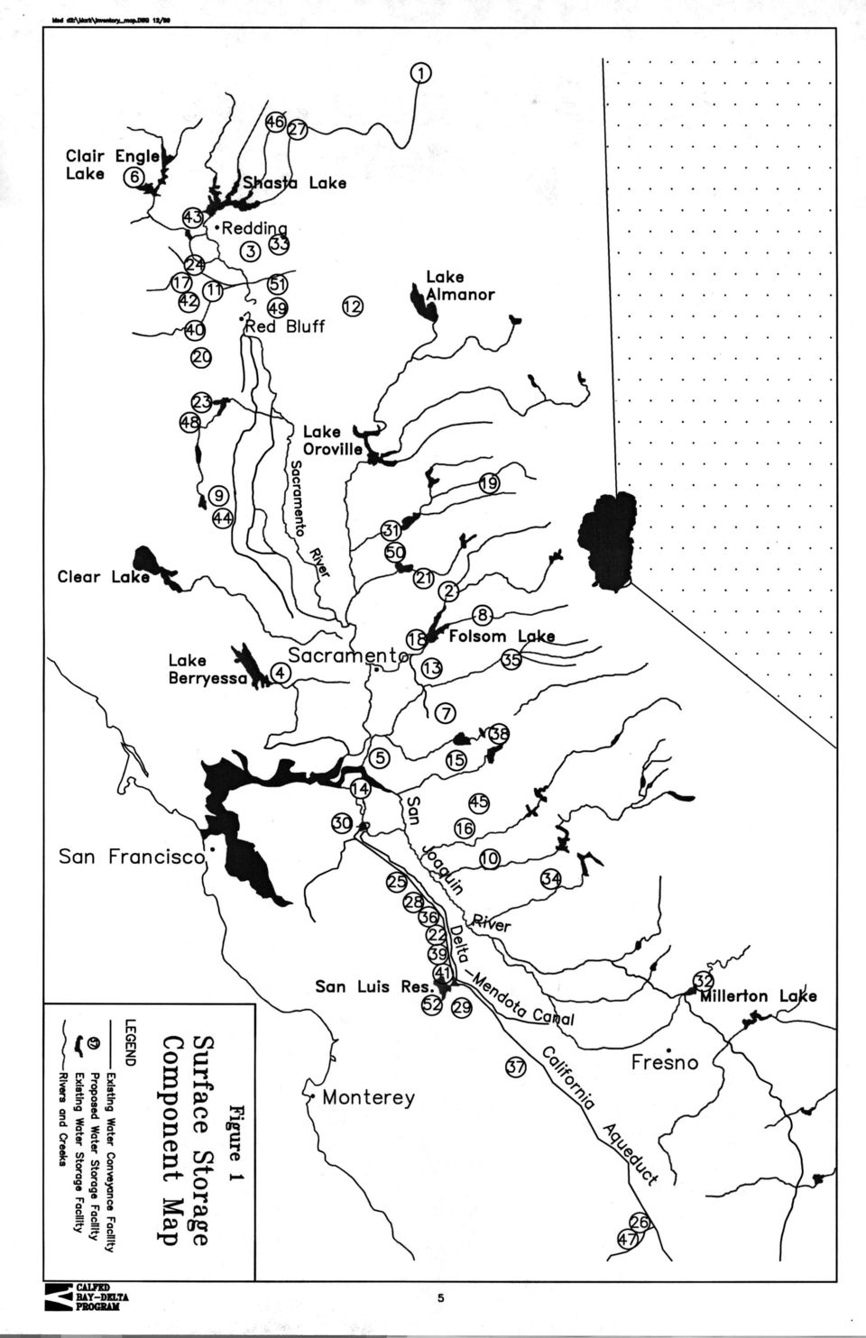
10 Surface Water Storage Components Gross Storage Component Location Type Description Capacity West Side Sacramento Valley Trinity Lake Enlargement (Site 6) Colusa Reservoir Complex (Site 9) Cottonwood Creek Reservoir Complex (Site 11) Fiddlers Reservoir (Site 17) Gallatin Reservoir (Site 20) Glenn Reservoir (Site 23) Hulen Reservoir (Site 24) Lake Berryessa Enlargement (Site 4) Red Bank Project (Dippingvat- Schoenfield Project) (Site 40) Rosewood Reservoir (Site 42) Shasta Lake Enlargement (Site 43) Sites Reservoir (Site 44) Thomes-Newville Reservoir (Site 48) Trinity County Trinity River Colusa/Glenn Counties Funks Creek Tehama/Shasta Counties Cottonwood Creek Tehama/Shasta Counties M.F. Cottonwood Creek Tehama County Elder Creek Glenn/Tehama Counties Stony Creek Shasta County N.F. Cottonwood Creek Napa County Putah Creek Tehama County S.F. Cottonwood Creek Shasta/Tehama Counties Salt Creek and Dry Creek Shasta County Sacramento River Colusa and Glenn Counties Funks & Stone Corral Cks Glenn County Thomes & Stoney Creek Enlarged Existing On-Stream Storage Develop in conjunction with pump/conveyance facility; transports Shasta storage to Trinity Lake. Additional 4,800 TAF Storage for new westside canal and Sacramento River flows. 3,300 TAF Combined On-stream and Off- Stream Storage Storage for new westside canal and Sacramento River flows. Includes Dutch Gulch and Tehama Reservoirs. 1,600 TAF On-Stream Storage Storage for new westside canal and Sacramento River flows. 310 to 545 TAF On-Stream Storage Increase regulating capabilities and yield opportunities. 183 TAF Storage for Tehama-Colusa Canal or new westside canal. 8,206 TAF On-Stream Storage Increase regulating capabilities and yield opportunities. 96 to 244 TAF Storage for North Bay Aqueduct and/or new westside canal. Additional 4.4 to 11.7 TAF - Schoenfield Provide flood control and water supply opportunities. Reservoir; On-Stream Storage -Dippingvat Reservoir Dippingvat-104 TAF Schoenfield-250 TAF On-Stream Storage Increase regulating capabilities and yield opportunities. 155 TAF On-Stream Storage Increase regulating capabilities and yield opportunities. Up to additional 9,750 TAF Storage for Tehama-Colusa Canal or new westside canal. 1,200 to 1,900 TAF Storage for Tehama-Colusa Canal or new westside canal. 1,840-3,080 TAF 6

11 Surface Water Storage Components Gross Storage Component Location Type Description Capacity East Side Sacramento Valley Allen Camp Reservoir (Site 1) Auburn Reservoir (Site 2) Bella Vista Reservoir (Site 3) Coloma Reservoir (Site 8) Deer Creek Meadows Reservoir (Site 12) Folsom Reservoir Enlargement (Site 18) Freemans Crossing Reservoir (Site 19) Garden Bar Reservoir (Site 21) Kosk Reservoir (Site 27) Marysville Reservoir (Site 31) Millville Reservoir (Site 33) Squaw Valley Reservoir (Site 46) Tuscan Buttes Reservoir (Site 49) Waldo Reservoir (Site 50) Wing Reservoir (Site 51) Modoc County Pit River Placer County N.F. American River Shasta County Little Cow Creek El Dorado County S.F. American River Tehama County Deer Creek El Dorado, Placer, and Sacramento Counties American River Yuba/Nevada Counties Middle Yuba River Sutter County Bear River Shasta County Pit River Yuba County Yuba River Shasta County South Cow Creek Shasta County Squaw Valley Creek Tehama County Paynes & Inks Creeks Yuba County Dry Creek Shasta County Inks Creek On-Stream Storage Increase regulating capabilities and yield opportunities. 196 TAF On-Stream Storage Increase regulating capabilities and yield opportunities. 315 to 2,300 TAF On-Stream Storage Increase regulating capabilities and yield opportunities in the northern Sacramento Valley. 146 TAF On-Stream Storage Increase regulating capabilities and yield opportunities. 710 TAF On-Stream Storage Increase regulating capabilities and yield opportunities. 200 TAF Enlarged Existing On-Stream Storage Increase regulating capabilities and yield opportunities. Additional 365 TAF On-Stream Storage Increase regulating capabilities and yield opportunities. 300 TAF On-Stream Storage Provide water supply opportunities in conjunction with Camp Far West and Oroville Reservoirs. 245 TAF On-Stream Storage Increase regulating capabilities and yield opportunities. 800 TAF On-Stream Storage Increase regulating capabilities and yield opportunities from the Yuba River. 916 TAF On-Stream Storage Increase regulating capabilities and yield opportunities. 206 TAF Combined Off-Stream and On- Stream Storage Storage for Sacramento River flows. 400 TAF Increase regulating capabilities and yield opportunities. 3,675 to 5,500 TAF Storage for Yuba River flows. 60 to 300 TAF On-Stream Storage Increase regulating capabilities and yield opportunities. 244 TAF Surface Water Storage Components 7

12 In-Delta Gross Storage Component Location Type Description Capacity Chain of Lakes Facility (Site 5) Sacramento/San Joaquin Delta Island Storage in Delta A chain of contiguous island storage facilities from the north Delta to the export Facilities. In-Delta Storage (Site 14) Sacramento/San Joaquin Delta Island Storage in Central or Island storage in the Delta for Delta flows. Southern Delta South-of-Delta Aqueduct Storage 300 to 600 TAF 230 TAF Garzas Reservoir (Site 22) Ingram Canyon (Site 25) Kettleman Plain (Site 26) Little Salado-Crow Reservoir (Site 28) Los Banos Grandes (Site 29) Los Vaqueros Enlargement (Site 30) Orestimba Reservoir (Site 36) Panoche Reservoir (Site 37) Quinto Creek Reservoir (Site 39) Romero Reservoir (Site 41) Stanislaus County Garzas Creek Stanislaus County Ingram Creek Kings County Kettleman Hill Stanislaus County Crow Creek Merced County Los Banos Creek Contra Costa County Kellogg Creek Stanislaus County Orestimba Creek Fresno County Silver Creek Merced/Stanislaus County Quinto Creek Merced County Romero Creek Off-aqueduct storage for the California Aqueduct or the Delta-Mendota Canal. Off-aqueduct storage for the California Aqueduct or the Delta-Mendota Canal. Off-aqueduct storage for the California Aqueduct or the Delta-Mendota Canal. Off-aqueduct storage for the California Aqueduct or the Delta-Mendota Canal. Off-aqueduct storage for the California Aqueduct or the Delta-Mendota Canal. Off-aqueduct storage for the California Aqueduct or the Delta-Mendota Canal. Off-aqueduct storage for the California Aqueduct or the Delta-Mendota Canal. Off-aqueduct storage for the California Aqueduct or the Delta-Mendota Canal. Off-aqueduct storage for the California Aqueduct or the Delta-Mendota Canal. Off-aqueduct storage for the California Aqueduct or the Delta-Mendota Canal. San Luis Reservoir Enlargement (Site 52) Merced County Off-aqueduct storage for the California Aqueduct or the Delta-Mendota Canal. Sunflower Reservoir (Site 47) Kings/Kern Counties Avenal Creek Surface Water Storage Components Off-aqueduct storage for the California Aqueduct or the Delta-Mendota Canal. 139 to 1,754 TAF 333 to 1,201 TAF 133 to 283 TAF 132 to 250 TAF 275 to 2,030 TAF Additional 965 TAF (100 TAF under const.) 380 to 1,140 TAF 160 to 3,100 TAF 332 to 381 TAF 184 TAF Additional 390 TAF 360 to 600 TAF Gross Storage Component Location Type Description Capacity San Joaquin Valley 8
 Los Vaqueros Enlargement (Site 30) Orestimba Reservoir (Site 36) Panoche Reservoir (Site 37) Quinto Creek Reservoir (Site 39) Romero Reservoir (Site 41) Stanislaus County Garzas")
13 Clay Station (Site 7) Sacramento County Storage for American River flows. 170 TAF Laguna Creek Cooperstown Reservoir (Site 10) Stanislaus County Storage for Stanislaus and Tuolumne River flows. 609 TAF Deer Creek Reservoir (Site 13) Sacramento County Storage for American River flows. 600 TAF near Rancho Murietta Duck Creek Reservoir (Site 15) San Joaquin County Calaveras watershed Storage for Mokelumne and Calaveras River flows. 100 TAF Farmington Reservoir Enlargement (Site 16) San Joaquin County Littlejohns Creek Millerton Lake Enlargement (Site 32) Montgomery Reservoir (Site 34) Fresno County San Joaquin River Merced County Dry Creek Nashville Reservoir (Site 35) El Dorado/Sacramento Counties - Cosumnes River Pardee Reservoir Enlargement (Site 38) South Gulch Reservoir (Site 45) Calaveras/Amador Counties Mokelumne River Combined On-Stream and Off- Stream Storage The existing reservoir would be improved for conservation storage of surplus Stanislaus River flows conveyed through the Upper Farmington Canal. 100 TAF On-Stream Storage Increase flow regulating opportunities. 720 TAF Capture and store spills from Lake McClure. 240 TAF Combined Off-Stream and On- Stream Storage Storage for Cosumnes River flows. 1,155 TAF On-Stream Storage Increase regulating capabilities and yield opportunities. Additional 150 TAF San Joaquin County Store flows from the Calaveras and Stanislaus Rivers. 180 TAF South Gulch tributary to Calaveras River 9
 San Joaquin County Littlejohns Creek Millerton Lake Enlargement (Site 32) Montgomery Reservoir (Site 34) Fresno County San Joaquin River Merced")
14 Small Storage Capacity Screening Reservoirs could help meet CALFED objectives by capturing water for flood control, water supply, water quality control, and environmental enhancement. The storage and conveyance evaluation process is designed to address the resource conflicts surrounding the timing and allocation of flows within the Bay-Delta system, including its tributaries. In order to significantly affect the CALFED solution for these conflicts, the cumulative volume of new surface storage would likely need to be significant; on the order of a million acre-feet or more (see the range of analyses presented in the June 1999 Draft Programmatic EIS/EIR). There are many small reservoir sites available for development by CALFED but the inventory of potential reservoir sites includes only those larger than 100,000 acre-feet. While new storage volume to meet CALFED objectives might be obtained by the combined effect of several small reservoirs, the cumulative cost and environmental impact of constructing several small reservoirs would be much higher than one larger project. For example, depending on the location, an individual 100,000 acre-foot reservoir would be expected to improve dry year water yield by only 10 to 30 TAF. Many of these smaller reservoirs would be required to have an influence on meeting CALFED objectives. More surface area and riverine habitat would likely be inundated through construction of several of these small facilities as compared to construction of one larger facility. Therefore, CALFED has applied a threshold of 200,000 acre-feet for initial screening. CALFED Agencies believe the smaller reservoirs are best left as candidates for potential development by local entities to meet specific local needs. Reservoir sites recommended for elimination from further CALFED consideration based on the minimum capacity criterion include: Sites Eliminated Based on Small Capacity Site Number on Figure 1 Reservoir Site Gross Storage Capacity 1 Allen Camp Reservoir 196 TAF 3 Bella Vista Reservoir 146 TAF 7 Clay Station Reservoir 170 TAF 15 Duck Creek Reservoir 100 TAF 16 Farmington Reservoir Enlargement 100 TAF 20 Gallatin Reservoir 183 TAF 38 Pardee Reservoir Enlargement Additional 150 TAF 41 Romero Reservoir 184 TAF 42 Rosewood Reservoir 155 TAF 45 South Gulch Reservoir 180 TAF 10
.")
15 Conflict with CALFED Objectives, Solution Principles, or Policy Early in the Program, CALFED developed a mission statement, a set of objectives, and a set of solution principles to guide a solution to problems in the Bay-Delta system. Potential new surface storage reservoirs must not violate these (see the following box). CALFED BAY-DELTA PROGRAM MISSION STATEMENT, OBJECTIVES AND SOLUTION PRINCIPLES The mission of the is to develop a long-term comprehensive plan that will restore ecological health and improve water management for beneficial uses of the Bay-Delta system. CALFED developed the following objectives for a solution: C C C C Provide good water quality for all beneficial uses; Improve and increase aquatic and terrestrial habitats and improve ecological functions in the Bay-Delta to support sustainable populations of diverse and valuable plant and animal species Reduce the mismatch between Bay-Delta water supplies and current and projected beneficial uses dependent on the Bay-Delta system Reduce the risk to land use and associated economic activities, water supply, infrastructure and the ecosystem from catastrophic breaching of Delta levees. In addition, any CALFED solution must satisfy the following solution principles: C Reduce Conflicts in the System Solutions will reduce major conflicts among beneficial uses of water. C C C C C Be Equitable Solutions will focus on solving problems in all problem areas. Improvements for some problems will not be made without corresponding improvements for other problems. Be Affordable Solutions will be implementable and maintainable within the foreseeable resources of the Program and stakeholders. Be Durable Solutions will have political and economic staying power and will sustain the resources they were designed to protect and enhance. Be Implementable Solutions will have broad public acceptance and legal feasibility, and will be timely and relatively simple to implement compared with other alternatives. Have No Significant Redirected Impacts Solutions will not solve problems in the Bay-Delta system by redirecting significant negative impacts, when viewed in their entirety, within the Bay-Delta or to other regions of California. 11

16 While CALFED considered potential conflicts with each of the four objectives in the above table, only the ecosystem objective resulted in conflicts for this initial screening. To meet the ecosystem objective, the CALFED Ecosystem Restoration Program (ERP) is proposing substantial actions to rehabilitate the natural processes in the Bay-Delta estuary and its watershed to support, with minimal ongoing human intervention, natural aquatic and associated terrestrial biotic communities, in ways that favor native members of those communities. Reservoir sites which significantly limit the success of the ERP are in direct conflict with the CALFED ecosystem objective. The Essential Fish Habitat covered in the Sustainable Fisheries Act of 1996 is one helpful measure of potential conflict. Those reservoir sites which conflict with CALFED objectives are considered to be infeasible based on logistics as defined in the Section 404(b)(1) Guidelines. The six solution principles (see box on previous page) have guided CALFED Program development from the beginning. Reservoir sites that violate these solution principles should not be carried forward. Reservoir sites which violate one or more of the CALFED solution principles would also generally be infeasible based on cost or logistics as defined in the Section 404(b)(1) Guidelines. For example, a site that is not durable or implementable would be infeasible based on logistics as defined in the Section 404(b)(1) Guidelines. A site considered to unaffordable based on the CALFED solution principle would also be infeasible based on cost in the Section 404(b)(1) Guidelines. Essential Fish Habitat (EFH) Public Law , the Sustainable Fisheries Act of 1996, amended the Magnuson-Stevens Fishery Conservation and Management Act to establish new requirements for Essential Fish Habitat description in Federal Fishery Management Plans (FMPs) and to require Federal agencies to consult with the National Marine Fisheries Service on activities that may adversely affect EFH. The amended act requires the National Marine Fisheries Service to assist the Pacific Fisheries Management Council in the description and identification of EFH for each managed fishery and to provide the Pacific Fishery Management Council with proposed recommendations for EFH (National Marine Fisheries Service 1998a). Essential Fish Habitat is the aquatic habitat necessary to allow for salmon production needed to support a long-term sustainable salmon fishery and salmon contributions to a healthy ecosystem. The salmon fishery EFH includes all those streams, lakes, ponds, wetlands, and other water bodies currently or historically accessible to salmon. In the estuarine and marine areas, salmon EFH extends from the nearshore and tidal submerged environments to 60 km offshore. Salmon EFH excludes areas upstream of longstanding naturally impassible barriers (i.e., natural waterfalls in existence for several hundred years) (National Marine Fisheries Service 1998a). The designation of these habitats is important to allow the systematic protection of biological diversity within distinct geographic regions. The application of such a conservationoriented classification system is of particular importance in the Central Valley where a rapidly growing human population and large tracts of irrigated agriculture compete with aquatic organisms for water (Moyle and Ellison 1991). References Moyle. P.B., and J.P. Ellison A conservation-oriented classifications system for the inland waters of California. California Fish and Game 77(4): National Marine Fisheries Service. 1998a. Proposed recommendations for Amendment 14 to the Pacific Coast Salmon Plan for Essential Fish Habitat (Draft). March 26, pp. 12

17 As a mater of policy, CALFED will focus on offstream reservoir sites for new surface storage, but will consider expansion of existing onstream reservoirs. CALFED will not pursue storage at new on-stream reservoir sites due to environmental impacts and implementability issues. Off-stream storage generally results in fewer environmental impacts then new on-stream storage. On-stream storage generally has much higher impacts on the aquatic environment than off-stream storage. For example, on-stream storage changes free flowing stream habitat to still reservoir habitat, blocks fish movement, and blocks sediment and nutrient transport to downstream areas. The off-stream sites, filled primarily by diversion, are generally located on small or intermittent drainages where the impacts on the aquatic environment are much smaller than with Offstream Storage Traditionally, reservoirs have been created by constructing dams on major rivers to form artificial lakes. These reservoirs are considered onstream storage. In contrast, an offstream storage reservoir is typically constructed on a small and generally seasonal stream that does not significantly contribute to the water supply of the reservoir. Offstream storage involves diverting water out of a river and transporting the water through canals or pipelines to a reservoir that may be miles away from the river. Therefore, offstream storage investigations include extensive evaluation of conveyance facilities to carry the water to the reservoirs. on-stream reservoirs located on major rivers or tributaries. CALFED Agencies believe mitigation costs will be substantially less with the off-stream reservoirs which will make the onstream reservoirs infeasible based on cost in the Section 404(b)(1) Guidelines. In addition, CALFED Agencies believe that most on-stream sites will have such high aquatic environmental impacts, that cannot be mitigated, that the sites would not be able to be developed. This would make the sites infeasible based on logistics as defined in the Section 404(b)(1) Guidelines. The following table shows those sites that were screened out due to conflicts with CALFED objectives, solution principles or policy. The paragraphs following the table provide a brief explanation of each reservoir and why they are recommended for elimination from further CALFED consideration. 13

18 Sites Eliminated Based on Conflicts with CALFED Objectives and Solution Principles Site No. ( Figure 1) Reservoir Site Conflict 2 Auburn Reservoir Implementability 4 Lake Berryessa Enlargement Implementability & significant redirected impacts 5 Chain of Lakes Facility Implementability & durability 6 Trinity Lake Enlargement Affordability & immpementability 8 Coloma Reservoir Implementability 10 Cooperstown Reservoir Implementability 11 Cottonwood Creek Complex Ecosystem objectives 12 Deer Creek Meadows Reservoir Ecosystem objectives 13 Deer Creek Reservoir Ecosystem objectives 17 Fiddlers Reservoir Ecosystem objectives 18 Folsom Reservoir Enlargement Implementability 19 Freemans Crossing Reservoir Does not reduce conflicts in the system 21 Garden Bar Reservoir Policy 22 Garzas Reservoir Implementability 23 Glenn Reservoir Implementability 24 Hulen Reservoir Ecosystem objectives 26 Kettleman Plain Implementability & does not reduce conflicts in the system 27 Kosk Reservoir Implementability & does not reduce conflicts in the system 28 Little Salado-Crow Reservoir Affordability, implementability & does not reduce conflicts in the system 29 Los Banos Grandes Reservoir Significant redirected impacts 31 Marysville Reservoir Ecosystem objectives 33 Millville Reservoir Ecosystem objectives 35 Nashville Reservoir Ecosystem objectives 36 Orestimba Reservoir Implementability 52 San Luis Reservoir Enlargement Implementability, significant redirected impacts & does not reduce conflicts in the system 46 Squaw Valley Reservoir Implementability 47 Sunflower Reservoir Implementability & does not reduce conflicts in the system 49 Tuscan Buttes Reservoir Ecosystem objectives 51 Wing Reservoir Ecosystem objectives 52 Waldo Reservoir Implementability Auburn Reservoir (No. 2 on Figure 1) - Auburn Reservoir would be located on the North Fork 14

19 American River, upstream of Folsom Reservoir. Reservoir sizes up to 2.3 million acre-feet were considered. The largest dam would inundate over 40 miles of the north and middle forks of the American River and 10,000 acres of the American River Canyon. Adverse environmental impacts have been termed unacceptable and unmitigable by the U.S. Environmental Protection Agency, U.S. Fish and Wildlife Service (USFWS), and California Department of Fish and Game. The reservoir would not be implementable due to these impacts and lack of public support. Since the reservoir would be on-stream, it is not consistent with CALFED policy. For these reasons, Auburn Reservoir is recommended for elimination from further CALFED consideration. Lake Berryessa Enlargement (No. 4 on Figure 1) - The existing Lake Berryessa (1.6 MAF) is located on Putah Creek about 8 miles west of the town of Winters in Solano County. The enlargement would require a new dam about 2 miles downstream of the existing dam. Depending on the dam size, the enlarged reservoir would have a gross capacity from 6.0 to 13.3 MAF. The enlargement would also include the construction of new conveyance facilities featuring a 12,000-foot-long tunnel that would serve to move water into and out of storage. The primary purpose of enlarging Lake Berryessa would be to store a portion of high flows from the Sacramento River. The Department of Fish and Game has concluded that the enlargement of Lake Berryessa would adversely impact wildlife (including endangered species) as a result of loss of habitat. The Lake Berryessa Enlargement would inundate an additional 15,600 to 43,600 acres (dependent on the enlargement option) of terrestrial wildlife habitat and several miles of warm water stream habitat. Vegetation within the inundation area of the 13.3 MAF lake consists primarily of the following approximate acreages: 24,000 acres of foothill woodland, 10,400 acres of scrub, 6,700 acres of grassland, 4,000 acres of agricultural lands, 1,600 acres of riparian vegetation, and 900 acres of disturbed areas. The large lake size would also result in larger diversions from the Sacramento River than most of the other potential storage sites creating increased impacts on Sacramento River fisheries. Additional concerns associated with the Berryessa Enlargement stem from the potential seismic activity in the area and the filling of the large reservoir. The northwest-southeast trending ridge-valley topography of the Coast Range north of San Francisco Bay results from the northwest-southeast trending faults which cover much of the area. These faults run approximately parallel to the San Andreas Fault, which lies about 50 miles west of the project location. Considerable development around the existing lake would be inundated by an enlargement of the lake. Because of this development and the environmental concerns, the enlargement of Lake Berryessa would be very controversial. The enlargement would violate CALFED solution principles due to the significant redirected impacts on the ecosystem and would not be implementable due to these impacts, lack of public support, and extremely large size of the development. For these reasons, the enlargement of Lake Berryessa is recommended for elimination from further CALFED consideration. Chain of Lakes Facility (No. 5 on Figure 1) - With this facility, six major Delta islands would 15

20 be converted to reservoirs connected with siphons and pumps to act as a conveyance of water supply through the Delta and water storage up to 600 TAF. This facility would result in large scale loss of prime agricultural lands, would have significant potential for degrading the quality of export water supplies, and would be very expensive, compared to other conveyance and storage alternatives. The Chain of Lakes Facility was originally conceived primarily as one potential form of an isolated conveyance facility. However, it would be considerably more expensive than an isolated facility sited along the eastern side of the Delta. In addition, CALFED has decided that its Preferred Program Alternative does not include an isolated facility (see the June Draft Programmatic EIS/EIR). The storage included with the Chain of Lakes Facility would have been a secondary function of the facility. Since the Chain of Lakes primary purpose of conveyance is not feasible for the CALFED Program, CALFED Agencies believe that further consideration of In-Delta storage be conducted solely as a storage function (see Inor Near Delta Storage on page 36). Based on these factors, the Chain of Lakes Facility violates several CALFED solution principles. The project would not be affordable for the above mentioned reasons. The project would not be implementable due to widespread opposition to the large scale disruption of the Delta. In addition, the durability of the project is questionable due to uncertainty on several factors including how it could affect in-delta and export water quality or potential vulnerability to earthquakes. Therefore, the Chain of Lakes Facility is recommended for elimination from further CALFED consideration. Trinity Lake Enlargement (No. 6 on Figure 1) - The existing Trinity Lake (formerly know as Clair Engle Lake) is located on the Trinity River. Since 1963, a portion of Trinity River flows have been diverted through a tunnel into the Sacramento River basin to augment Central Valley Project water supplies in the Sacramento and San Joaquin valleys. These diversions have averaged about 880,000 acre-feet annually. Minimum flow released to the Trinity River were initially set at 120,500 acre-feet per year but have been temporarily increased to 340,000 acrefeet due to severe declines in Trinity River salmon and steelhead trout runs. Permanent flow release criteria have been recommended based on the Secretary of Interior s flow evaluation study and EIS. The flow evaluation study results in more water remaining in the Trinity River, especially during wetter years when higher flows help maintain the configuration and health of the river channel, and less water will be available for diversion to the Sacramento River basin. This will result in less natural runoff available for storage. Given that less water will be available for storage during wetter years, it is unlikely that an enlargement of Trinity Lake can develop significant water from the natural watershed. This small potential for increased water supply would not significantly reduce conflicts in the system. The project could be expanded by pumping unregulated flood flows from Shasta Lake for storage in Trinity Lake and returning water to Shasta Lake in time of need. A 200-foot raise of the dam would increase the storage of Trinity Lake by about 4.8 million acre-feet. The communities of Trinity Center, Coffee Creek, and Coveington Mill and numerous resort areas and recreational facilities along with 20 miles of State Highway 30 would need to be relocated. The expanded lake would flood numerous historical sites along with a significant coniferoushardwood forest, meadow, and riparian habitats. CALFED Agencies believe that expansion of 16

21 the lake, and the large diversions from Shasta Lake to support it, would create significant environmental impacts. The scale of the project is so large that CALFED Agencies believe it would not be affordable nor implementable within a reasonable period to help meet CALFED objectives. Therefore, the Trinity Lake Enlargement is recommended for elimination from further CALFED consideration. The US Bureau of Reclamation is investigating options to correct potential dam safety concerns related to spillway capacity and potential for an earthquake-triggered landslide in the reservoir area. These concerns have led to a temporary limit on maximum reservoir storage. The options of a small raise in the reservoir embankment and modifications to spillways and outlets are under considerations to correct the dam safety concerns. Investigation of these dam safety concerns and correction measures is supported by CALFED. Coloma Reservoir (No. 8 on Figure 1) - The reservoir site is located on the South Fork American River and would flood the Gold Discovery Site State Park at Coloma. The California Water Code provides for protection of the historic site as follows: Water Code ?Notwithstanding any provisions of this article or any other provision of law to the contrary, the project known as the "Coloma Dam and Reservoir" constitutes no part of the State Water Plan. In no event shall a permit to appropriate water be issued by the State for the purposes of a project which will flood any portion of the Gold Discovery Site State Park at Coloma unless such issuance is specifically authorized by law. Since this project would be in conflict with existing law, it is not considered implementable. The maximum size reservoir that would not flood the State Park is 200 TAF which would not pass the minimum capacity criterion described above. Also, since the reservoir would be on-stream, it is not consistent with CALFED policy. For these reasons, the Coloma Reservoir is recommended for elimination from further CALFED consideration. Cooperstown Reservoir (No. 10 on Figure 1) - Cooperstown Reservoir would be located in Stanislaus County on Dry Creek between Stanislaus and Tuolumne Rivers. Most of the information on the project comes from a 1949 report (A Comprehensive Department Report on the Development of Water and Related Resources of the Central Valley Basin, and Comments from the State of California and Federal Agencies) by the Department of the Interior. While the specific facility designs have not been determined for Cooperstown, the reservoir would have a capacity up to 609 TAF. The general project features would include a new embankment dam, and fourteen to sixteen saddle dams depending on the size of reservoir selected. Project costs would be driven up significantly by the numerous saddle dams that would be required to develop this project. The reservoir would be relatively shallow, inundating an area of 15,400 acres. No environmental analysis has been conducted for the Cooperstown Reservoir. Cooperstown could operate in conjunction with the upstream New Melones Reservoir and New Don Pedro Reservoirs by storing a portion of the flows released from both reservoirs. In addition, Cooperstown Reservoir could enhance operations of the New Melones Reservoir by 17
22 storing winter power releases, thus permitting power production during the non-irrigation season without loss of irrigation water. There has been very little information developed on this project in the last 50 years which raises uncertainties regarding its viability. Considering that the dam site is not a particularly good one due to the many required saddle dams, it is unlikely to compare favorably with other potential reservoir sites. CALFED does not consider Cooperstown Reservoir to be implementable compared to other reservoirs remaining for CALFED consideration. Cottonwood Creek Reservoir Complex (No. 11 on Figure 1) - The Cottonwood Creek complex would consist of a major (900 TAF) reservoir on the mainstem of Cottonwood Creek and a major (700 TAF) reservoir on the South Fork Cottonwood Creek. The complex would inundate 28 miles of stream and riparian habitat. Cottonwood Creek is the largest undammed tributary in the upper Sacramento River basin and is the most important source of sediments to the Sacramento River. These sediments are necessary to drive river meander and riparian rejuvenation that is important to the CALFED ERP. The creek is likely to be designated (still in draft proposal stage) as Essential Fish Habitat (EFH) by the National Marine Fisheries Service and the Pacific Fisheries Management Council. The creek provides spawning for fall-run and late-fall-run chinook salmon and supports spring-run chinook salmon in some years. Given the importance of Cottonwood Creek to Sacramento River health and fishery production, CALFED Agencies believe that Cottonwood Creek Reservoir Complex would be in direct conflict with the CALFED ecosystem restoration objectives. Since the reservoir would be onstream, it is not consistent with CALFED policy. For these reasons, the Cottonwood Creek Reservoir Complex is recommended for elimination from further CALFED consideration. Deer Creek Meadows Reservoir (No. 12 on Figure 1) - Deer Creek Meadows Reservoir would be located on Deer Creek in Tehama County. The creek is likely to be designated (still in draft proposal stage) as Essential Fish Habitat by the National Marine Fisheries Service and the Pacific Fisheries Management Council. The creek supports an important population of springrun chinook salmon and is a priority watershed for early implementation of the ERP. CALFED Agencies believe that Deer Creek Meadows Reservoir would be in direct conflict with the CALFED ecosystem restoration objectives. In addition, since the reservoir would be onstream, it is not consistent with CALFED policy. Therefore, the Deer Creek Meadows Reservoir is recommended for elimination from further CALFED consideration. Deer Creek Reservoir (No. 13 on Figure 1) - Deer Creek Reservoir would be an off-stream reservoir to store American River water. Downstream from Nimbus Dam, the American River is likely to be designated (still in draft proposal stage) as Essential Fish Habitat and supports fallrun chinook salmon and steelhead. The two ecological factors with the greatest influence on anadromous fishes of the lower American River are seasonal stream flow and water temperature. New storage on the American River could help the seasonal flows and the cold water pool, but diversions to an off-stream reservoir could jeopardize opportunity to provide cold water to the lower American River. 18
23 CALFED Agencies believe that Deer Creek Reservoir would be in direct conflict with the CALFED ecosystem restoration objectives. Therefore, the Deer Creek Reservoir is recommended for elimination from further CALFED consideration. Fiddlers Reservoir (No. 17 on Figure 1) - Fiddlers Reservoir would be located on the Middle Fork Cottonwood Creek. Like the Cottonwood Creek Complex, Fiddlers Reservoir would block important sediment flow to the Sacramento River and is likely to be designated (still in draft proposal stage) as Essential Fish Habitat. Fiddlers Reservoir has been suggested as an alternative to the Cottonwood Creek Complex and has also been considered in combination with Hulen and Dippingvat Reservoirs. Fiddlers Reservoir, by itself or in conjunction with Hulen and Dippingvat Reservoirs, could not provide the same level of benefits as either the Cottonwood Creek Complex or the Red Bank Project. CALFED Agencies believe that Fiddlers Reservoir would be in direct conflict with the CALFED ecosystem restoration objectives. Also, since the reservoir would be on-stream, it is not consistent with CALFED policy. Therefore, the Fiddlers Reservoir is recommended for elimination from further CALFED consideration. Folsom Reservoir Enlargement (No. 18 on Figure 1) - The existing Folsom Reservoir can store approximately 1 million acre-feet on the American River east of Sacramento. The potential 30-foot raise of the dam and its many saddle dams would store an additional 365 TAF. Since the reservoir is located within a populated area, enlargement by 30 feet would face major legal, institutional, and socioeconomic issues. Folsom Lake State Recreation Area is one of the most popular units in the State Park System hosting upwards of 2-3 million visitors each year. The enlargement would inundate 3.4 miles of stream habitat and high instream recreational uses on the South and North Fork American River. Options for increased flood protection for the City of Sacramento have been under investigation by the USACE and the Sacramento Area Flood Control Agency since a major flood on the American River in Potential options include modifications to Folsom Dam, its operation, and downstream levees to reduce flood risk along the lower American River. Operation rules for the existing Folsom Dam have already been modified to temporarily improve flood protection until a more permanent solution is found and implemented. These operations for flood control have resulted in reduced winter-time conservation storage for water supply. Potential flood control modifications to the dam include constructing new low level outlets so flood storage could be more quickly evacuated in anticipation of flood events and raising the dam and saddle dams by as much as 12 feet. Preliminary studies by the USACE indicate that the 12-foot raise, which would add about 140,000 acre-feet flood storage capacity, is near the practical physical limit and could provide Sacramento 200 year flood protection. The studies found that a larger raise would require major reconstruction of the interface between the main concrete dam and its earthfill embankments and the increased lake level would begin to significantly impact existing lakeside development. CALFED Agencies believe that the 30-foot Folsom Reservoir Enlargement is not implementable as a CALFED project. There would be significant local resistance to the enlargement 19
24 considering the existing adjacent development, the number of saddle dams that must be raised above populated areas, and the high recreational use. The cost of raising the dam (30 feet) and many saddle dams would be very high considering the relatively small increase in storage capacity. The value of any CALFED related enlargement for water supply would likely be diminished by local plans for flood control for the City of Sacramento. The smaller, more practical, raise of approximately 12 feet (140,000 acre-feet) is smaller than the CALFED minimum capacity criterion described above. CALFED Agencies believe that any potential Folsom Dam modifications should be reserved for local flood control needs. Therefore, the Folsom Dam Enlargement is recommended for elimination from further CALFED consideration. Freemans Crossing Reservoir (No. 19 on Figure 1) - Freemans Crossing, on the Middle Fork Yuba River, was proposed in DWR Bulletin 3 in 1957 as a place to store water diverted from the North Fork Yuba River. In the late 1960s, Yuba County Water Agency's New Bullards Bar Project developed the upper Yuba by putting the major storage on the North Fork and diverting a big share of the Middle Fork water to it via the Camptonville Tunnel. This has significantly reduced the water available for a Freemans Crossing Reservoir. Due to the lack of water, this project will do little to reduce conflicts in the system. Also, since the reservoir would be on-stream, it is not consistent with CALFED policy. Therefore, the Freemans Crossing Reservoir is recommended for elimination from further CALFED consideration. Garden Bar Reservoir (No. 21 on Figure 1) - Garden Bar reservoir would be located on the Bear River upstream of Camp Far West Reservoir. The 320-foot-high dam would form a 245 TAF reservoir and inundate 2,000 acres of deer wintering, riparian, and wetlands habitat. The river is likely to be designated (still in draft proposal stage) as Essential Fish Habitat and supports anadromous fish during the wetter years downstream of Camp Far West Reservoir. Storage of water in the new reservoir would reduce these wetter year flows and negatively impact anadromous fish. The gross storage capacity (245 TAF) is only slightly larger than those reservoir sites eliminated due to small storage capacity. Since the reservoir would be on-stream, it is not consistent with CALFED policy. Therefore, the Garden Bay Reservoir is recommended for elimination from further CALFED consideration. Garzas Reservoir (No. 22 on Figure 1) - Garzas Reservoir would be an off-stream reservoir in Stanislaus County, west of the California Aqueduct. Its potential active storage range if from 139 to 1,754 TAF. The project would inundate 15 miles of Garzas Creek, and 2,600 acres of wildlife habitat. The USFWS (draft letter May 21, 1999) provided the following information on the habitat values of the Garzas and Orestimba Reservoir sites: This property, including these reservoir sites, is an important component of a habitat corridor connecting the northernmost population of the endangered San Joaquin kit fox (Vulpes macrotis mutica) in Contra Costa County to the southern portions of the kit fox s range in Merced County and further south. Localized kit fox populations, like the one in 20
25 Contra Costa County, are known to undergo occasional, rapid declines; long-term maintenance of such populations depends on the preservation of viable corridors allowing the migration of individual kit fox among populations. Preservation of this habitat corridor is identified in the Service s 1998 Recovery Plan for Upland Species of the San Joaquin Valley, California, as necessary to prevent a significant decline in the population of San Joaquin kit foxes. However, this habitat corridor has already been greatly narrowed by the conversion of natural and range lands, as well as some row crops, to orchards or more intensive agricultural development, and by development along the I-5 corridor. In addition, the construction and operation of San Luis Reservoir and its ancillary facilities just south of this site has created a narrow pinch point in the habitat corridor, which increases the value of a wider, more diverse and protective corridor both north and south of San Luis. Construction of either proposed reservoir would extend this too-narrow habitat corridor so far that its long-term existence, and thus the maintenance of gene flow between the northern and southern components of the kit fox s range, could not be assured. This would result in a significant risk to the longterm survival and recovery of the San Joaquin kit fox. Stream corridors on this property, including Garzas and Orestimba creeks, also contain the largest known population of threatened California red-legged frogs (Rana aurora draytonii) in the Central Valley watershed. California red-legged frogs were historically common in the Central Valley (they are now unknown from the valley floor), and recovery of the frog will likely depend on the reestablishment of several viable populations throughout its historic range. The frogs on this property are thought to be the closest genetic descendants of the red-legged frogs once found throughout the valley, and are expected to have and important role in the potential reintroduction of California red-legged frogs to suitable habitat elsewhere in the Central Valley watershed. Thus, construction of either reservoir could not only affect one of the few remaining red-legged frog populations but also, through its effects on that population, pose a significant risk to the recovery of the California red-legged frog. The Garzas Reservoir site is on land recently acquired by The Nature Conservancy to protect the habitat and other ecological values of the property. A portion of the funding for this acquisition was provided by the Department of the Interior, as part of a program to mitigate for the impacts of the Central Valley Project. One condition of the Department in providing funds to support this acquisition was that the nature Conservancy grant a perpetual conservation easement to protect the fish and wildlife value at his site. The terms of this easement, which prohibit additional water development on the property, would preclude construction of the storage reservoir. Based on the above information, this project is not implementable and is recommended for elimination from further CALFED consideration. Glenn Reservoir (No. 23 on Figure 1) - The Glenn Reservoir Project would be located in Glenn and Tehama counties. The Newville Dam would be located on the North Fork of Stony Creek and the Rancheria Dam would be constructed on the main stem of Stony Creek. The two 21
26 reservoir compartments would merge to form Glenn Reservoir with a combined storage capacity up to 8,206 TAF. A new 15-mile conveyance component between Glenn Reservoir and the SWP, a large Rancheria Dam on the main stem of Stony Creek and a Newville Dam on the North Fork of Stony Creek would comprise the major components of the Glenn Reservoir Project. Glenn Reservoir would provide off-stream storage of runoff from Stony and Thomes Creeks and pumped flows from the Sacramento River. The reservoir would inundate several miles The largest Glenn Reservoir alternative would require a dam about 420 feet above the river plain. The reservoir would inundate over 50,000 acres. Vegetation in the project area consists primarily of grasslands, oak savannah, oak-pine woodland, and chaparral. Riparian vegetation occurs along the numerous rivers and streams in the area. Vernal pools have been found scattered throughout the project area. In addition, the reservoir would inundate an estimated 223 prehistoric, 35 ethnographic and 70 significant historic sites in the project area. One of the more significant results of constructing this complex would be the loss of critical winter range for an estimated 1,100 deer of the Thomes Creek (Lake Hollow) herd and the displacement of over 600 migratory and resident deer. Construction will block migration routes for mule deer. Potential impacts to steelhead and salmon may also result from the loss of a portion of their periodic run. Impacts include blockages of migration routes, migration delays, loss of spawning habitat, changes in spawning substrate, loss of directional flows, decreased water quality, and increased water temperatures. The impact of run blockage for Sacramento squawfish and suckers is expected to be significant. Indirect fish losses can be expected at the project's Sacramento River diversion. The Newville Reservoir on North Fork Stony Creek could inundate stretches of perennial and intermittent streams that are used primarily by roach, suckers and squawfish migrating from Black Butte Reservoir to spawn and rear. Additional environmental concerns relate to the excessive sediment, debris, and fishery problems associated with winter diversion of approximately 10,000 cfs from critical reaches of the Sacramento River. Some other potential problems that became apparent during earlier studies are (1) local opposition related to displacing the town of Elk Creek and numerous ranches, (2) inundation of the Grindstone Indian Rancheria, (3) possible water quality impacts of releases back to the river, and (4) unresolved seismicity issues. In addition, the size of the reservoir is much larger than that considered viable at this point in the. CALFED Agencies believe the project would not be implementable due to these impacts, lack of public support, and extremely large size of the development. For these reasons, the Glenn Reservoir is recommended for elimination from further CALFED consideration. Hulen Reservoir (No. 24 on Figure 1) - Hullen Reservoir would be located on North Fork of Cottonwood Creek. Its maximum potential size (244 TAF) is only slightly larger than those reservoir sites eliminated due to small storage capacity. In addition it, like the Cottonwood Creek Complex, would block important sediment flow to the Sacramento River and is likely to be designated (still in draft proposal stage) as Essential Fish Habitat. CALFED Agencies believe that Hulen Reservoir would be in direct conflict with the CALFED ecosystem restoration objectives. Also, since the reservoir would be on-stream, it is not 22
27 consistent with CALFED policy. Therefore, the Hulen Reservoir is recommended for elimination from further CALFED consideration. Kettleman Plain Reservoir (No. 26 on Figure 1) - Kettleman Plain Reservoir would be an offstream reservoir in Kings County, west of the California Aqueduct. Its potential size range (133 to 283 TAF) is relatively small compared with many other reservoir sites that could be operated in conjunction with the California Aqueduct. The largest reservoir would inundate over 9,000 acres. The resultant reservoir would be very shallow (average depth approximately 30 feet) with high evaporation losses. The shallow depth would also contribute to poorer reservoir water quality. Due to relatively small size, the high evaporation, and water quality problems of the shallow reservoir, this project is not likely to be implementable and will do little to reduce conflicts in the system. Based on this information, the Kettleman Plain Reservoir is recommended for elimination from further CALFED consideration. Kosk Reservoir (No. 27 on Figure 1) - Kosk Reservoir would be located on the Pit River approximately two miles downstream from the community of Big Bend. The project would inundate 12 miles of intermittent stream habitat. This would likely eliminate the Shasta slender salamander, a State-listed threatened species, and its habitat. Given this, it is unlikely that the project would be implementable. In addition, water yield from new storage on the Pit River is not expected to be significant so it is unlikely that the reservoir would significantly reduce conflicts in the system. Also, since the reservoir would be on-stream, it is not consistent with CALFED policy. For these reasons, the Kosk Reservoir is recommended for elimination from further CALFED consideration. Little Salado-Crow Reservoir (No. 28 on Figure 1) - Little Salado-Crow Reservoir would be an off-stream reservoir in Stanislaus County, west of the California Aqueduct. Its potential size range (132 to 250 TAF) is relatively small compared with many other reservoir sites that could be operated in conjunction with the California Aqueduct. The largest reservoir would inundate approximately 3,000 acres. The resultant reservoir would be shallow with high evaporation losses. Prior studies by DWR (Alternative South-of-the-Delta Offstream Reservoir Reconnaissance Study, Phase One) showed that this site was relatively expensive compared with other potential off-stream reservoirs that could be operated in conjunction with the California Aqueduct. This project is not likely to be implementable and will do little to reduce conflicts in the system. Based on this information, the Little Salado-Crow Reservoir is recommended for elimination from further CALFED consideration. Los Banos Grandes Reservoir (No. 29 on Figure 1) - Los Banos Grandes Reservoir would be a major off-stream reservoir connected to the California Aqueduct. Previous studies indicate that water from the Los Banos Grandes Reservoir would be significantly less expensive than other off-aqueduct storage. While Los Banos Grandes is by far the best off-aqueduct site for water operations, it does pose significant environmental concerns. The reservoir site contains 23
28 approximately one-quarter of the Central California Sycamore Alluvial Woodland natural community. The Los Banos Reservoir site contains the largest stand (426 acres) while all other stands in Central California are under 250 acres. Depending on the reservoir size, up to 13,000 acres of terrestrial wildlife habitat and 13 miles of intermittent stream and associated habitat would be inundated. The six listed species that could be affected by the proposed reservoir include Valley elderberry longhorn beetle (Federal threatened), blunt-nosed leopard lizard (Federal endangered/state endangered), bald eagle (State endangered), Swainson s hawk (State threatened), giant kangaroo rat (Federal and State endangered), and San Joaquin kit fox (Federal endangered/state threatened). Additionally, the Arburua Ranch jewelflower (Streptanthus insignis spp. Iyonii) is known only from the Los Banos Grandes area and locations nearby. This project would inundate some population of this species. Although this plant is currently unlisted, construction of this project would cause serious concerns for its future viability. In a September 18, 1997 letter to the, the USFWS stated that Los Banos Grandes Reservoir would not be easily mitigated and suggested that attempts to mitigate for the reservoir could fail. The letter states: Special attention should be given to impacts at the Los Banos Grandes and Auburn reservoir sites. We believe that full mitigation for these impacts would not be easy. This is not just a question of economic feasibility; rather, the fish and wildlife resources that would be impacted by construction of either project are extremely valuable, and existing habitat restoration techniques--and the geographic extent of appropriate land--are extremely limited, and that mitigation could likely fail regardless of the financial resources available to attempt it. The sycamore woodlands at this site are one of the oldest and most pristine in the State. If it were possible to replace these woodlands, it would take over 200 years to reach the existing maturity of the stand. Flooding of the sycamore woodlands and grasslands pose concerns for the San Joaquin kit fox due to the loss habitat for the reservoir and ancillary facilities and due to the barrier that the reservoir would create to movement of kit fox from one side to the other: C Flooding the site would result in displacement of the only known population (12-28 individuals) inhabiting Valley floor grasslands and loss of 13,000 acres of denning and foraging habitat including 50 known kit fox dens and 425 potential dens. The displacement of this kit fox population would result in them moving to other areas where they would experience increased competition and mortality from the non-native red fox and feral dogs. These impacts would be amplified by project oriented recreation and ongoing operation and maintenance. C The reservoir would reduce free movement of kit fox from one side to the other. This loss of transportation corridor would isolate up to 65 kit foxes and negatively impact the gene flow between populations north and south of the reservoir. These major environmental concerns would constitute significant redirected impacts. The Los Banos Grandes Reservoir is recommended for elimination from further CALFED consideration. 24
29 However, this may essentially eliminate the potential of economical off-aqueduct storage since other off-aqueduct options are significantly more expensive than Los Banos Grandes. New offaqueduct storage could significantly increase overall water supply reliability and flexibility of Delta export operations. If more detailed evaluations show that remaining off-aqueduct storage options are not affordable or should be eliminated from consideration for other reasons, then CALFED s ability to accomplish its water supply reliability objectives could be significantly affected. Marysville Reservoir (No. 31 on Figure 1) - Marysville Reservoir would be located on the mainstem of the Yuba River downstream of Englebright Reservoir. The river is likely to be designated (still in draft proposal stage) as Essential Fish Habitat and supports fall-run and spring-run chinook salmon. The Yuba River has the largest naturally spawning population of salmon in the Central Valley. The reservoir would inundate 47 miles of stream habitat and would incorporate the storage of Englebright Reservoir. Englebright Reservoir was built in 1941 to collect placer mining debris. The ERP proposes an evaluation of removing or modifying Englebright Reservoir to reopen upstream areas to anadromous fish. Marysville Reservoir would not only block a length of the Yuba River currently open to the fish, but would preclude the possibility of opening additional length above Englebright. CALFED Agencies believe that Marysville Reservoir would be in direct conflict with the CALFED ecosystem restoration objectives. Also, since the reservoir would be on-stream, it is not consistent with CALFED policy. Therefore, the Marysville Reservoir is recommended for elimination from further CALFED consideration. Millville Reservoir (No. 33 on Figure 1) - Millville Reservoir would be located on south Cow Creek. The creek is likely to be designated (still in draft proposal stage) as Essential Fish Habitat. CALFED Agencies believe that Millville Reservoir would be in direct conflict with the CALFED ecosystem restoration objectives. Since the reservoir would be on-stream, it is not consistent with CALFED policy. In addition, its proposed size of 206 TAF is only slightly larger than the reservoirs screened out for small storage capacity. Therefore, the Millville Reservoir is recommended for elimination from further CALFED consideration. Nashville Reservoir (No. 35 on Figure 1) - Nashville Reservoir would be located on the Cosumnes River approximately five miles north of Plymouth. The river has been designated as Essential Fish Habitat. In addition, the Cosumnes is the largest undammed tributary in the Sierras. CALFED Agencies believe that Nashville Reservoir would be in direct conflict with the CALFED ecosystem restoration objectives. Since the reservoir would be on-stream, it is not consistent with CALFED policy. Therefore, the Nashville Reservoir is recommended for elimination from further CALFED consideration. Orestimba Reservoir (No. 36 on Figure 1) - Orestimba Reservoir would be an off-stream reservoir in Stanislaus County, west of the California Aqueduct. Its potential active storage range is from 295 to 1,137 TAF. The project would inundate 33 miles of Orestimba Creek, and 2,200 acres of wildlife habitat. 25
30 The USFWS (draft letter May 21, 1999) provided the following information on the habitat values of the Garzas and Orestimba Reservoir sites: This property, including these reservoir sites, is an important component of a habitat corridor connecting the northernmost population of the endangered San Joaquin kit fox (Vulpes macrotis mutica) in Contra Costa County to the southern portions of the kit fox s range in Merced County and further south. Localized kit fox populations, like the one in Contra Costa County, are known to undergo occasional, rapid declines; long-term maintenance of such populations depends on the preservation of viable corridors allowing the migration of individual kit fox among populations. Preservation of this habitat corridor is identified in the Service s 1998 Recovery Plan for Upland Species of the San Joaquin Valley, California, as necessary to prevent a significant decline in the population of San Joaquin kit foxes. However, this habitat corridor has already been greatly narrowed by the conversion of natural and range lands, as well as some row crops, to orchards or more intensive agricultural development, and by development along the I-5 corridor. In addition, the construction and operation of San Luis Reservoir and its ancillary facilities just south of this site has created a narrow pinch point in the habitat corridor, which increases the value of a wider, more diverse and protective corridor both north and south of San Luis. Construction of either proposed reservoir would extend this too-narrow habitat corridor so far that its long-term existence, and thus the maintenance of gene flow between the northern and southern components of the kit fox s range, could not be assured. This would result in a significant risk to the longterm survival and recovery of the San Joaquin kit fox. Stream corridors on this property, including Garzas and Orestimba creeks, also contain the largest known population of threatened California red-legged frogs (Rana aurora draytonii) in the Central Valley watershed. California red-legged frogs were historically common in the Central Valley (they are now unknown from the valley floor), and recovery of the frog will likely depend on the reestablishment of several viable populations throughout its historic range. The frogs on this property are thought to be the closest genetic descendants of the red-legged frogs once found throughout the valley, and are expected to have and important role in the potential reintroduction of California red-legged frogs to suitable habitat elsewhere in the Central Valley watershed. Thus, construction of either reservoir could not only affect one of the few remaining red-legged frog populations but also, through its effects on that population, pose a significant risk to the recovery of the California red-legged frog. The Orestimba Reservoir site is on land recently acquired by The Nature Conservancy to protect the habitat and other ecological values of the property. A portion of the funding for this acquisition was provided by the Department of the Interior, as part of a program to mitigate for the impacts of the Central Valley Project. One condition of the Department in providing funds to support this acquisition was that the nature Conservancy grant a perpetual conservation easement to protect the fish and wildlife value at his site. The terms of this easement, which prohibit additional water development on the property, would preclude construction of the storage reservoir. 26
31 Based on the above information, this project is not implementable and is recommended for elimination from further CALFED consideration. San Luis Reservoir Enlargement (No. 52 on Figure 1) - The San Luis Reservoir is an existing off-stream reservoir which stores water exported from the Delta through the Delta Mendota Canal and the California Aqueduct. It stores over 2 million acre-feet and is a key component in serving water to agricultural and urban water users. San Luis Reservoir already creates a narrow pinch pint in the habitat corridor which runs along the west side of the San Joaquin Valley. A 40-foot raise of the dam would further narrow the habitat corridor in this area. To increase the dam height by 40 feet to store and additional 390 TAF, a portion of the existing dam structure would have to be excavated to allow for the extension of the drain and filter zones. A total of 16 million cubic yards of material would be removed from the existing dam requiring that the reservoir be out of service for two years. CALFED Agencies believe that the two year shutdown would create unacceptable water supply impacts. The two year shut-down would violate several CALFED solution principles. The shut-down for the enlargement would intensify conflicts rather than reduce conflicts in the system. The enlargement would create significant redirected impacts to water users while the existing San Luis Reservoir is out of service. The project would not be implementable unless the existing reservoir needed to be out-of-service for major repairs or other reasons sometime in the future. An enlargement in conjunction with a planned outage for another reason could be very attractive. Also, the enlargement could become implementable if it is preceded by another new large (1 to 2 million acre-feet) reservoir that could be filled through the Delta Mendota Canal and the California Aqueduct. At the current time, however, the San Luis Reservoir Enlargement is recommended for elimination from further CALFED consideration. Squaw Valley Reservoir (No. 46 on Figure 1) - Squaw Valley Reservoir would be located on Squaw Valley Creek, a tributary to the McCloud River. The reservoir would inundate 7 miles of riparian and stream habitat in an area which receives heavy recreational use. It would store natural runoff and water diverted through an 11 mile-long tunnel from the Sacramento River. The diversion would significantly reduce flows in the upper Sacramento River which would cause a major impact on its premium riverine habitat. Based on the heavy recreational use and the reduced flow in the upper Sacramento River, CALFED Agencies believe the projects would not be implementable. In addition, the proposed 400 TAF of storage appears larger than is justified based on the natural flow in Squaw Valley Creek and diversions from the Sacramento. The Squaw Valley Reservoir is recommended for elimination from further CALFED consideration. Sunflower Reservoir (No. 47 on Figure 1) - Sunflower Reservoir would be an off-stream reservoir in Kings and Kern Counties, west of the California Aqueduct. Its potential size range (322 to 535 TAF) is relatively small compared with many other reservoir sites that could be operated in conjunction with the California Aqueduct. The largest Sunflower Reservoir would inundate almost 11,000 acres. The resultant reservoir would be very shallow (average depth approximately 50 feet) with high evaporation losses. The shallow depth would also contribute to poorer reservoir water quality. An extensive conveyance system consisting of 10 miles of canal and three pumping-generating plants would be required. In addition, over 130 active oil wells 27
32 are located within the reservoir area. Due to relatively small size, the high evaporation, and water quality problems of the shallow reservoir, this project is not likely to be implementable and will do little to reduce conflicts in the system. Based on this information, the Sunflower Reservoir is recommended for elimination from further CALFED consideration. Tuscan Buttes Reservoir (No. 49 on Figure 1) - Tuscan Buttes would be located on Paynes and Inks Creeks to store water diverted from the Sacramento River. While Tuscan Buttes Reservoir is classified as an off-stream reservoir since it would be filled primarily from diversions, it also would create fishery impacts of an on-stream reservoir. Paynes Creek supports a small population of fall-fun chinook salmon and some steelhead trout and there are records of fall-run chinook salmon in Inks Creek. The creeks are likely to be designated (still in draft proposal stage) as Essential Fish Habitat. The potential storage size is from 3,675 to 5,500 TAF. The Reservoir would inundate 6 miles of cold-water stream habitat, 19,000 acres of primarily blue oak woodland and grassland habitat. One of the biggest concerns with the project is that due to its size, a much larger diversion (than say Sites Reservoir) would be required from the Sacramento River with associated impacts on salmon populations in the Sacramento River. CALFED Agencies believe that Tuscan Buttes Reservoir would be in direct conflict with the CALFED ecosystem restoration objectives. Therefore, the Tuscan Buttes Reservoir is recommended for elimination from further CALFED consideration. Waldo Reservoir (No. 50 on Figure 1) - Waldo Reservoir would be located in Yuba County on Dry Creek and would serve as an off-stream storage facility primarily for Yuba River flows (up to 1000 cfs) diverted from Englebright Lake. Water from the Bear River would also be diverted for storage in the reservoir. Waldo Reservoir could have a gross storage capacity from 60 to 300 TAF and inundate up to 4,220 acres, including 3,600 acres of the Spenceville Wildlife Area. The wildlife area is managed by the State Department of Fish and Game and is primarily foothill oak woodland. The quitclaim between the United States and the Department of Fish and Game for the lands that now make up the Spenceville Wildlife Area reserved the right for the United States to inundate the area below elevation feet MSL. Dry Creek within the Spenceville Wildlife Area is spawning habitat for fall-run chinook salmon and steelhead trout. The Department of Fish and Game concludes that the project will impact numerous plant and animal species and habitats including known and potential State-and Federally-listed rare, threatened and endangered animal species, resident and migratory deer and deer migratory routes, known and potential State-and Federally-listed plant species, and numerous potential and designated State Species of Special Concern. In a Department of Fish and Game letter (January 27, 1997) on the project, the Department summarizes these impacts: The Spenceville Wildlife Area has exceptional species richness and contains many game and nongame species and unique and diminishing habitats. The project will also affect herpetofauna, waterfowl, upland game, resident and winter migrant raptors, neotropical migrants, hardwood habitats, wetland habitats, riparian habitats, oak savannah habitats, 28
33 and animal movement corridors. There are also numerous recreational activities and facilities in the Spenceville Wildlife Area that would be inundated by a reservoir. DFG manages the Spenceville Wildlife Area to support hunting, fishing, horseback riding, bike trails, hiking, camping, and general outdoor activities. In addition to the above environmental and recreational concerns, there may be a need to mitigate on site water quality. The abandoned Spenceville mine would be inundated by the proposed reservoir. The mine site includes an estimated 100,000 cubic yards of mine tailings and discharge of acidic (heavy metal) mine drainage that would likely need cleanup prior to building the project. CALFED is currently investigating the potential of removal or modification of Englebright Dam to reopen areas upstream of the dam to anadromous fish. If it proves viable to open the upper Yuba River to anadromous fish, the diversion to Waldo Reservoir could pose a significant negative impact to the fisheries. In addition, the diversion could become significantly more expensive without Englebright Dam. Waldo Reservoir is being pursued as a local project by the Yuba County Water Agency. The reservoir could provide local flood control benefits, water for Area-of-Origin water users, and water for transfer. Project planning includes a pipeline to northern Sacramento Metropolitan area. The reservoir is relatively small in size to contribute significantly to CALFED's water supply reliability objective. Considering this small size and the interest in Waldo Reservoir as a local project, CALFED Agencies believe that Waldo Reservoir would not significantly reduce conflicts in the system and is not likely implementable as a CALFED project. Therefore, Waldo Reservoir is recommended for elimination from further CALFED consideration. The site is best left for further evaluation and potential development as a local project. Wing Reservoir (No. 51 on Figure 1) - Wing Reservoir would be located on Inks Creek at the same location as the Tuscan Buttes Reservoir. Wing Reservoir would directly store flows from Inks Creek and flows diverted by gravity from adjacent Paynes and Battle Creeks. All three creeks are likely to be designated (still in draft proposal stage) as Essential Fish Habitat. The major diversion would be from Battle Creek. Battle Creek supports fall- and spring-run chinook salmon and steelhead trout. Battle Creek is a priority watershed for early implementation of the ERP. Part of the ERP is removal of some diversions from Battle Creek. CALFED Agencies believe that Wing Reservoir would be in direct conflict with the CALFED ecosystem restoration objectives. Therefore, the Wing Reservoir is recommended for elimination from further CALFED consideration. 29
34 Sites Remaining for Additional CALFED Consideration After the above screening based on small size and conflict with CALFED objectives and solution principles and policy focusing on off-stream reservoirs, twelve sites remain from the original inventory: No. 9 Colusa Reservoir No. 14 In-Delta Storage No. 25 Ingram Canyon No. 30 Los Vaqueros Enlargement No. 32 Millerton Lake Enlargement No. 34 Montgomery Reservoir No. 37 Panoche Reservoir No. 39 Quinto Creek Reservoir No. 40 Schoenfield Reservoir No. 43 Shasta Lake Enlargement No. 44 Sites Reservoir No. 48 Thomes-Newville Reservoir A brief description of each reservoir can be found on the following pages. Those remaining following the screening are summarized for each of five regions: West Side Sacramento Valley, East Side Sacramento Valley, West Side/Off-Aqueduct San Joaquin Valley, In- or Near Delta, and East Side San Joaquin Valley. West Side Sacramento Valley Runoff from upstream tributaries to the Delta usually occurs in large volumes over short periods of time in the winter and spring. New storage upstream of the Delta could store a portion of these flows in excess of instream flow requirements and water supply needs. While detaining water in storage, care must be taken to maintain periodic peak flow events in rivers that provide for natural fluvial geomorphological processes, including the moving and cleansing of gravels, which are important to aquatic ecosystems. This is a more vital consideration associated with enlarged on-stream storage compared to off-stream storage; large amounts of water can quickly be detained in on-stream storage, while due to conveyance capacity constraints, only a minor percentage of large peak river flows can be diverted to off-stream storage. 30
35 Water could be released from upstream surface storage when needed to supplement instream flows and water supply. Water could be released to meet direct needs or to provide additional benefits through exchanges. For example, water could be released from off-stream storage in the Sacramento River basin directly to local water users, reducing existing diversions from the Sacramento River during periods critical to fisheries. Water released for environmental purposes could include pulse flows to help transport fish through the Delta. Water could also be released to provide sustained flows for riverine and shallow water habitats and improve water quality in the Delta during drier years. Five potential reservoirs were retained for additional CALFED consideration: Colusa Reservoir Complex (No. 9 of Figure 1) - The Colusa Reservoir Complex would be an off-stream storage located in Antelope Valley (within Colusa and Glenn counties) about 10 miles west of Maxwell. The Complex would be an extension of Sites Reservoir (see No. 44 below) to the north and would include two additional large dams where Hunters and Logan Creeks pass through the Logan Ridge and numerous small saddle dams along Logan Ridge. The Complex would have a total of 3.3 MAF of storage capacity and would be filled through pumped diversions from the Sacramento River from several alternative diversion configurations. One alternative is the enlargement of the Tehama-Colusa Canal to a capacity of 5,000 cfs. An additional evaluation for a new diversion from the Sacramento River near Chico Landing, the Chico Landing Intertie, would include a new screened diversion facility from the Sacramento River and conveyance facility, which would connect it to the Tehama-Colusa Canal upstream of Sites/Colusa Reservoir. The present evaluation of the Sites/Colusa Project will be combined with both of the above evaluations to develop several alternative comprehensive projects, which could become part of the CALFED solution strategy. The Colusa Reservoir Project could inundate 29,600 acres of terrestrial wildlife habitat and 25 miles of intermittent stream habitat. Vegetation at the Colusa Reservoir Project consists primarily of grasslands (23,065 acres) comprised of wild oat, brome grass, and fescues. About 10 percent of the land is planted in barley (1,300 acres of agriculture). Some valley needlegrass grassland communities may be found in the area. The woodlands (1,345 acres) are comprised mostly of blue oaks and can be found throughout the area, particularly in the western upland areas. Riparian vegetation (220 acres) occurs along Antelope, Stone Corral, Funks, and Grapevine Creeks; however, these areas have been severely degraded as a result of overgrazing and extensive cultivation to the stream edges. The majority of the riparian vegetation found in this area consists of sycamore, willow, and cottonwood. Aquatic plant species found in the drainage areas include bulrush, cattail, rush, and smartweed. Approximately 120 acres of disturbed area exists within the reservoir area. Additional environmental concerns are associated with the diversion of water from the Sacramento River for storage. Neither the Tehama-Colusa nor the GCID diversions are designed for winter use, when sediment and debris may compound fish screening difficulties. Potential water quality problems associated with releases back to the river can be circumvented via exchanges whereby existing canal diversions would be all or partially replaced by releases from 31
36 storage. Schoenfield Reservoir (No. 40 on Figure 1) - The Red Bank project is comprised a 104 TAF Dippingvat Reservoir on South Fork Cottonwood Creek, a 250 TAF Schoenfield Reservoir on Red Bank Creek and connecting tunnels, canals, and two small reservoirs. The primary source of water developed by the project would be from South Fork Cottonwood Creek with water diverted from Dippingvat Reservoir to Schoenfield Reservoir. However, the Red Bank Project may better contribute to CALFED objectives in a reconfigured form. The reconfigured project would be centered around storage in Schoenfield Reservoir that could be used early in the irrigation season to serve demands of the Corning and Tehama-Colusa canals. In turn, diversions to the canals from the Sacramento River at Red Bluff Diversion Dam would be unnecessary during this period. Fish passage at the Red Bluff Diversion Dam is a longstanding problem that has been partially solved through reoperation. The gates are currently in place from mid-may to mid-september to form Lake Red Bluff and facilitate diversion to the canals. The remainder of the year, when the gates are raised, the lake is gone and fish can freely pass the dam. Serving the Corning and Tehama-Colusa canals from Schoenfield Reservoir early in the irrigation season could allow raising the gates at Red Bluff Diversion Dam an additional month or more. This could provide significant benefit for fish passage at the dam. As mentioned previously, Cottonwood Creek is the largest undammed tributary in the upper Sacramento River basin and is the most important source of sediments to the Sacramento River. These sediments are necessary to drive river meander and riparian rejuvenation that is important to the CALFED ERP. The South Fork is likely to be designated (still in draft proposal stage) as Essential Fish Habitat (EFH) by the National Marine Fisheries Service and the Pacific Fisheries Management Council. The creek provides spawning for fall-run and late-fall-run chinook salmon and supports spring-run chinook salmon in some years. Given the importance of South Fork Cottonwood Creek to Sacramento River health and fishery production, CALFED Agencies believe that Dippingvat Reservoir should not be considered at the scale shown in the inventory. However, a smaller diversion structure which does not prevent the passage of the sediments or fish may be warranted. An optional small diversion from the Sacramento River to Schoenfield Reservoir should also be evaluated. This would allow transfer of water from Shasta Dam to Schoenfield Reservoir on a reliable basis. Shasta Lake Enlargement (No. 43 on Figure 1) - The existing Shasta Lake on the upper Sacramento River has a storage capacity of about 4.5 million acre-feet. Potential enlargements of the existing dam up to feet higher were considered in the above water yield and economic screening. The highest dam would store over 9 million acre-feet more than the existing dam. The highest dam would inundate 30,000 acres of Shasta-Trinity nation Recreation area, 4 miles of the McCloud River, and 6 miles of the Sacramento River. About 42 miles of tributary stream would be inundated. The highest dam would also require relocation of more than 800 people, 800 camp units, 100 picnic units, marinas and moorings for 2800 boats, 14 resorts, Interstate Highway 5, the Southern Pacific Railroad, and PG&E s Pit No. 7 Power Plant. Based on these significant impacts and the above water yield and economic screening, only a small Shasta Lake Enlargement appears implementable for CALFED consideration. 32
37 In the California Pubic Resources Code Section , the Legislature declared that the McCloud River possesses extraordinary resources in that it supports one of the finest wild trout fisheries in the state. The Code Section further states: No dam, reservoir, diversion, or other water impoundment facility shall be constructed on the McCloud River from Algoma to the confluence with huckleberry Creek, and 0.25 mile downstream from the McCloud Dam to the McCloud River Bridge: nor shall any such facility be constructed on Squaw Valley Creek from the confluence with Cabin Creek to the confluence with the McCloud River. While the Code seeks to protect the free-flowing state of the McCloud River, it also provides for potential enlargement of Shasta Dam: Except for participation by the Department of Water Resources in studies involving the technical and economic feasibility of enlargement of Shasta Dam, no department or agency of the state shall assist or cooperate with, whether by loan, grant, license, or other wise, any agency of the federal, state, or local government in the planning or construction of any dam, reservoir, diversion, or other water impoundment facility that could have an adverse effect on the free-flowing condition of the McCloud River, or on its wild trout fishery. Preliminary water yield and economic evaluations shows that an option with a 6.5 foot raise of the existing Shasta Dam to produce the most economical water of any site investigated. This option maximizes storage without relocating Interstate Highway 5 and the Union Pacific Railroad and minimizes relocation of recreational facilities within the reservoir area. Based on this information, CALFED will not consider a Shasta Lake Enlargement larger than the 6.5 foot raise. Sites Reservoir (No. 44 on Figure 1) - Sites Reservoir would be an off-stream storage located about 10 miles west of Maxwell in Antelope Valley across the drainages of Stone Corral and Funks Creeks. The main dams and most of the project area would lie within northern Colusa County. Two alternative Sites Reservoirs are being considered including, the Small Sites Reservoir with 1.2 MAF of total storage capacity, and the Large Sites Reservoir with 1.9 MAF of total storage capacity. The Small Sites Reservoir would be formed by two large zoned-earth dams: Golden Gate Dam on Funks Creek and Sites Dam on Stone Corral Creek. Five earthen dikes would also be required. The maximum operating water surface elevation would be at 480 feet above mean sea level (MSL) and would inundate approximately 12,300 acres. The Large Sites Reservoir, with a maximum operating water surface elevation of 532 feet, would inundate approximately 14,700 acres. The reservoir would be formed by Golden Gate Dam on Funks Creek, Sites Dam on Stone Corral Creek, and 12 saddle dams, ranging in height from 27 to 112 feet, along Logan Ridge. As with the dams described for the Small Sites Reservoir Project, Golden Gate and Sites Dams would be zoned earth embankments. The reservoir would be filled through pumped diversions from the Sacramento River. One alternative for filling of Sites Reservoir is the enlargement of the Tehama-Colusa Canal to a 33
38 capacity of 5,000 cfs. An additional alternative under evaluation is for a new pumped diversion from the Sacramento River near Chico Landing. The most significant loss of wildlife habitat would be 700 acres of oak-woodland, which is considered breeding habitat for many species of reptiles, amphibians, birds, and mammals. Vegetation at the Sites Project area consists primarily of grasslands comprised of wild oat, brome grass, and fescues. About 10 percent of the land is planted in barley. Some valley needlegrass grassland communities may be found in the area. The woodlands comprised mostly of blue oaks and can be found throughout the area, particularly in the western upland areas. Riparian vegetation occurs along Antelope, Stone Corral, Funks, and Grapevine Creeks; however, these areas have been severely degraded as a result of overgrazing and extensive cultivation to the stream edges. The majority of the riparian vegetation found in this area consists of sycamore, willow, and cottonwood. Aquatic plant species found in the drainage areas include bulrush, cattail, rush, and smartweed. Additional environmental concerns are associated with the diversion of water from the Sacramento River for storage. Neither the Tehama-Colusa nor the GCID diversions is designed for winter use, when sediment and debris may compound fish screening difficulties; however, Potential water quality problems associated with releases back to the river can be circumvented via exchanges whereby existing canal diversions would be all or partially replaced by releases from storage. Preliminary water yield and economic evaluations shows that, after the small Shasta Lake enlargement, Sites Reservoir produces the most economical water of the site investigated. Thomes-Newville Reservoir (No. 48 on Figure 1) - Thomes-Newville Reservoir would be located on the North Fork Stony Creek and would filled by diversions from the mainstem of Stony Creek, Thomes Creek, and the Sacramento River. The Newville Dam site would be located about 10 miles upstream of Black Butte Dam. Newville Dam would fill a low gap in the north-south trending Rocky Ridge. The Thomes-Newville Reservoir Project has been evaluated at two storage capacities: 1.84 MAF and 3.08 MAF. The smaller Thomes-Newville Reservoir would have a normal pool elevation of 900 feet above MSL. The larger Thomes-Newville Reservoir would have a normal pool elevation of 980 feet above MSL. A small (32,500 acre-feet) afterbay, Tehenn Reservoir, would be located Newville Dam. Depending on the reservoir configuration selected, the project could inundate up to 15,000 acres of terrestrial wildlife habitat and up to 35 miles of perennial stream habitat. One of the more significant results of constructing this complex would be the loss of over 2,000 acres of critical winter range for an estimated 1,100 deer of the Thomes Creek (Lake Hollow) herd and the displacement of over 600 migratory and resident deer. Construction will block migration routes for mule deer. Potential impacts to steelhead and salmon may also result from the loss of a portion of their periodic run. Impacts include blockages of migration routes, migration delays, loss of spawning habitat, changes in spawning substrate, loss of directional flows, decreased water quality, and increased water temperatures. The impact of run blockage for Sacramento squawfish and suckers is expected to be significant. Indirect fish losses can be expected at the 34
39 project's Sacramento River diversion. The Newville and Tehenn Reservoirs on North Fork Stony Creek could inundate stretches of perennial and intermittent streams that are used primarily by roach, suckers and squawfish migrating from Black Butte Reservoir to spawn and rear. The remaining free-flowing streams above the reservoirs could be used for spawning and the reservoir would create sufficient suitable habitat for adults and for rearing juveniles. Vegetation at the Thomes-Newville Reservoir Project consists primarily of grasslands, oak-pine woodland, and chaparral. Riparian vegetation occurs along the numerous rivers and streams in the area. Vernal pools have been found scattered throughout the project area in the past. In 1983, vegetation types were mapped and acreages were calculated utilizing maps and aerial photographs from U.S. Geological Survey (USGS) and USFWS. Habitat inventory of the project area was reported as follows: 12,020 acres of grasslands, 1,850 acres oak savannah, 420 acres of oak-pine woodland, 110 acres of chaparral, and 600 acres of riparian habitat. In addition to significant impacts on wildlife and plants within the reservoir area, potential problem areas include sediment and groundwater impacts on Thomes Creek and seismicity issues (including the possibility of reservoir-induced seismicity). The dam site is within the Coast Range geomorphic province immediately west of the boundary with the Great Valley geomorphic province. East Side Sacramento Valley None of the potential reservoirs on the east side of the Sacramento Valley were retained for additional CALFED consideration. Some of the reservoirs eliminated from CALFED consideration may be candidates for potential development by local entities to meet specific local needs. West Side/Off-Aqueduct San Joaquin Valley A version of off-stream storage, south of Delta off-aqueduct storage could be filled by diversions through the Delta Mendota Canal or the California Aqueduct. Examples of existing off-aqueduct storage include San Luis Reservoir and Castaic Lake. New off-aqueduct storage would be filled by increasing Delta exports during periods of high flows and least potential harm to Delta fisheries. Water stored in new off-aqueduct storage could be released to meet export needs while curtailing export pumping from the Delta during times of heightened environmental sensitivity in the Delta. Filling of off-aqueduct storage is limited by the capacity of export facilities. However, water stored in off-aqueduct storage is of great value to export water users, since it can be delivered directly for use without Delta operational constraints. Off-aqueduct storage can significantly improve system operational flexibility. Three potential reservoirs of different sizes were retained for additional CALFED consideration: Ingram Canyon Reservoir (No. 25 on Figure 1) - Ingram Canyon Reservoir would provide 35
40 new off-stream storage for flows pumped from the Delta. The site is located west of the California Aqueduct in Stanislaus County on Ingram Creek. Potential storage sizes range from 333 to 1,201 TAF. This is the medium size of the three sites retained. Very little engineering or environmental work has been conducted on the Ingram Canyon Reservoir Project. Panoche Reservoir (No. 37 on Figure 1) - Panoche Reservoir would provide new off-stream storage for flows pumped from the Delta. The site is located west of the California Aqueduct in Fresno/San Benito Counties on Panoche and Silver Creeks. Potential storage sizes range from 160 to 3,100 TAF. This is the large size of the three sites retained. Panoche Reservoir could provide varying benefits for recreation, flood protection, and local water supply. However, the system wide water supply and increased flexibility of operation to offset the impacts on Delta fish are considered to be the major benefits of this project. As with the existing San Luis Reservoir, a portion of the pumping energy would be recovered as water was released from the offstream reservoir to the aqueduct. A two-way water transfer between the reservoir and the California Aqueduct would include conveyance facilities and one or two pumping-generating plants. Very little engineering or environmental work has been conducted on the Panoche Reservoir Project. Quinto Creek Reservoir (No. 39 on Figure 1) - Quinto Creek Reservoir would provide new off-stream storage for flows pumped from the Delta. The site is located west of the California Aqueduct in Merced and Stanislaus County on Quinto Creek. Potential storage sizes range from 332 to 381 TAF. This is the small size of the three sites retained. Very little engineering or environmental work has been conducted on the Quinto Creek Reservoir Project. In- or Near-Delta A major concern in the south Delta is the effect of continuing exports, specifically entrainment and salvage of important fish species. To address this concern, CALFED is evaluating the concept of flexible operations. Flexible operations would allow reducing export pumping at times critical to fish and increasing export pumping at other times. For example, the SWP and CVP could reduce pumping when Delta inflow is low or when fish are present in large numbers and increase pumping when Delta inflow is high and few fish are present. New in-delta or near- Delta storage could significantly facilitate flexible operations by allowing pumping from storage at times rather than reducing pumping. Two of the reservoirs retained for future CALFED consideration include an in-delta reservoir and an enlargement of the Los Vaqueros Reservoir. In-Delta Reservoir (No. 14 on Figure 1) - In-Delta storage would be formed by converting one or more Delta islands to water storage of 200 TAF or more. Existing levees would be reconstructed and screened facilities for diverting water into the islands would be provided. In- Delta storage would be filled during high flow periods when potential harm to fisheries would be lowest. The storage could be filled and emptied several times in a year. Water could be released directly into the Delta during drier periods for environmental, in-delta water supply, or water 36
41 quality needs. A direct connection to State Water Project (SWP) and Central Valley Project (CVP) export facilities might also be provided to allow stored water to be exported during periods when curtailing south Delta diversions could benefit fisheries. Several concerns regarding in-delta storage must be resolved. If the stored water is to be used for drinking water purposes, there may be a need to evaluate sealing or removing the naturally occurring peat soils from the islands to avoid the release of organic carbons (organic carbons in a drinking water source contribute to the formulation of undesirable byproducts when treated with chlorine). This could add significant expense to any in-delta storage project. Foundation and slope stability concerns associated with Delta levees could limit the rate of water removal from in-delta storage, thereby reducing operational flexibility and potential benefits. Once the benefits and concerns are better defined, the need, size, and value of in-delta storage can be better determined. In-Delta storage needs to remain a viable option for future evaluation. Los Vaqueros Reservoir (No. 30 on Figure 1) - The existing Los Vaqueros Reservoir (100 TAF) is located in Contra Costa County, on the eastern slope of the Coast Range about 11 miles south of Antioch and 7 miles northwest of the Clifton Court Forebay. The enlargement would generally include the main Los Vaqueros Dam and Reservoir, one saddle dam, the Kellogg Forebay, and conveyance facilities including canals, pipelines, and pumping-generating plants. The enlarged Los Vaqueros Dam would create a reservoir with a normal water surface elevation of 780 feet above mean sea level (MSL), and area of 4,830 acres, and a storage capacity of MAF. The enlarged Los Vaqueros Reservoir would be a multipurpose water storage project designed to improve the water quality and reliability of the CVP and SWP and would be operated to augment the yield of the CVP and SWP, to increase the flexibility of Delta export operations for both projects, and to continue to meet the needs of CCWD. Available Delta flows would be pumped from Clifton Court Forebay to Kellogg Forebay via the Tuway Canal and then into the enlarged Los Vaqueros Reservoir via the Los Vaqueros Pumping-Generating Plant. Storage releases would also generate energy at the Los Vaqueros Pumping-Generating Plant. Depending on the configuration selected and the amount of right-of-way needed, enlarging the Los Vaqueros Reservoir from 100,000 acre-feet to just over one million acre-feet could impact up to 3,340 acres of primarily annual grasslands and terrestrial wildlife habitat. Approximately 92 percent of these lands are grasslands, seven percent are woodlands, and the remaining one percent is riparian. East Side San Joaquin Valley This storage, upstream of the Delta, could provide similar benefits as storage in the Sacramento Valley. Runoff from upstream tributaries to the Delta usually occurs in large volumes over short periods of time in the winter and spring. New storage upstream of the Delta could store a portion of these flows in excess of instream flow requirements and water supply needs. Water could be released from upstream surface storage when needed to supplement instream flows and 37
42 water supply. Water could be released to meet direct needs or to provide additional benefits through exchanges. Water released for environmental purposes could include pulse flows to help transport fish through the Delta. Water could also be released to provide sustained flows for riverine and shallow water habitats and improve water quality in the Delta during drier years. Two potential reservoirs were retained for additional CALFED consideration: Millerton Lake Enlargement - The existing Millerton Lake is located on the San Joaquin River about 25 miles east of Fresno. Millerton Lake inundates a portion of the Sierra Nevada foothill areas of Fresno and Madera Counties. The Millerton Lake Enlargement would consist of raising the height of the existing Friant Dam to increase the storage capacity of the reservoir by about 720,000 acre-feet (1,240,000 acre-feet total). Existing facilities such as the Madera and Friant-Kern Canals would require some modification at the outlet work from Friant Dam so they could continue to operate. The existing dam would be enlarged by adding concrete to the crest and downstream face. The crest height would be raised 144 feet to an elevation of 725 feet above MSL. An enlarged Millerton Lake would have a normal water surface elevation of 700 feet above MSL. The increased surface area and water surface elevation would inundate the Millerton Lake Recreational Area and PG&E's Kerckhoff No. 1 and No. 2 Powerhouses. Three saddle dams would be required to enlarge Millerton Lake. Two of the saddle dams would be adjacent to the main dam; the third would be about 3 miles east of the main dam. The Millerton Lake Enlargement could provide (1) greater flood control on the San Joaquin River, (2) additional water supplies to meet local needs, and (3) additional water supplies for water quality, agricultural, environmental, and urban uses in eastern San Joaquin Valley (or transfers to the South Coast). The project would store flows that are normally released or spilled during high flow times to the lower San Joaquin River and the Sacramento-San Joaquin Delta. Enlargement of the Millerton Reservoir could inundate up to 3,500 acres of wildlife habitat consisting primarily of blue-oak woodland, annual grassland, and chaparral. Other habitat types located around and upstream of the lake include montane hardwood- conifer, blue oak- digger pine, valley foothill riparian, and riverine. These habitats provide foraging areas and cover for a number of wildlife species. Vegetation in the area surrounding the lake is classified as Upper Sonoran Life Zone. There are two significant natural areas near Millerton Lake: the Friant South Significant Natural Area, located just below Friant Dam along the San Joaquin River and the Big Table Mountain Significant Natural Area, located on the southeast side of Millerton Lake. The area that would be impacted by the proposed enlargement is estimated to support approximately 10 miles of intermittent streambed, 2 miles of scrub-shrub wetlands (wet meadow), 5 miles of emergent temporarily flooded wetlands (wet meadow), 3 miles of upper perennial rock wetlands, and 3 miles of diked/impounded, emergent seasonally flooded wetlands (shallow marsh). Montgomery Reservoir - The Montgomery Reservoir Project would be a new offstream reservoir in northeastern Merced County about 60 miles southeast of the Sacramento-San Joaquin Delta. The potential storage is approximately 240 TAF. The dam site is located on Dry Creek about 16 miles above the confluence with the Merced River near the town of Snelling. The zoned earthfill dam would be constructed to a total height of 101 feet above the original 38
43 streambed. The crest of the dam would be at an elevation of 336 feet above mean sea level (MSL). At maximum conservation pool, the reservoir would have a water surface elevation of 325 feet above MSL. The 1961 Reclamation feasibility-level design includes eight saddle dams of various lengths and heights. The reservoir site would be located within the service area of Merced Irrigation District (MID), which supplies about 570,000 acre-feet of water per year for municipal and agricultural uses through its operation of New Exchequer Dam (Lake McClure). The primary purpose of the Montgomery Reservoir would be to develop an additional source to serve the local demands and to provide off-stream storage of spills on the Merced River and flood control on Dry Creek but could free up other water for CALFED purposes. A portion of high flows from the Merced River stored in Montgomery Reservoir would be used to meet local water needs by allowing water stored in Lake McClure to supplement environmental or water supply uses on either the San Joaquin River or the Delta. The water stored in Montgomery Reservoir would not be returned to the Merced River but would be discharged to an expanded North Side Canal via a pumping plant and new discharge pipeline. Some water placed in the canal would flow west by gravity to meet the needs of MID water users downstream of the turnout. Additional water placed in the canal would flow upstream from the pumping plant (east) in the North Side Canal to meet needs of MID customers located along the expanded North Side Canal between the Merced Falls Diversion Dam and Montgomery Reservoir. A portion of the water conveyed through the North Side Canal would be conveyed through the new Main Canal Pipeline to the MID Main Canal downstream of Snelling Dam. This water would be used to meet MID demands south of the Merced River. Depending on the reservoir configuration selected, the project could inundate up to 8,100 acres of terrestrial wildlife habitat. Vegetation at the Montgomery Reservoir site consists primarily of annual grasslands with many vernal pools. Many of the creeks and drainages in the Montgomery Reservoir area have one or more areas that support stands of cattails and tules. These wet areas occur both naturally along the creek bed and artificially in areas where impoundments have been constructed across the creek. The project area contains the following types of wetlands: emergent wet meadows, emergent shallow marshes, emergent deep marshes, scrub-shrub wetlands, ten lower perennial stream wetlands, two upper perennial stream wetlands, 18 intermittent streambeds, and numerous farm ponds. 39
44 Continuing Evaluations As part of its ongoing evaluation of storage, CALFED has initiated the Integrated Storage Investigation (ISI). The ISI will coordinate existing storage investigations by individual CALFED Agencies, CALFED-initiated storage evaluations and broader water management strategies and analysis to provide a comprehensive assessment of alternative storage options and their utility to overall water management. Project-specific studies of storage opportunities will be coordinated under the ISI. Specifically, the ISI will evaluate surface storage, groundwater storage, power facility reoperation where appropriate and the potential for conjunctive operation of these different types of storage. These investigations, as part of the water management strategy, will contribute to compliance with the Clean Water Act Section 404 Guidelines requirement to select the least environmentally damaging practicable alternative to constructing new storage facilities. Additionally, these investigations will provide a comprehensive assessment and prioritization of critical fish migration barriers for modification or removal. DWR is continuing work on its North of Delta Offstream Storage Study. Work during State fiscal year is focusing on environmental issues associated with construction of alternative offstream reservoirs, including 1) botanical, general vegetation, and sensitive plant species surveys, 2) wetlands delineations, 3) wildlife special status species inventories, and 4) avian, fish, amphibian, and reptile surveys. Some additional engineering and economic studies on storage and conveyance configurations will help focus environmental studies. A progress report documenting findings of the investigation to date was released to the public in February Reclamation recently completed an appraisal assessment of the potential for enlarging Shasta Dam and Reservoir. Three enlargement options were evaluated that involved a structural raise of the crest height of Shasta Dam by 6.5, 102.5, and feet. Reclamation concluded that he 6.5 foot raise has the least unit cost, minimizes both environmental and socioeconomic impacts, and would be the most viable project for further analysis in a feasibility-level investigation. Aerial photography was completed in August, 1999, however, anticipated topographic work was not completed due to high water levels in the reservoir. Reclamation will initiate a program to collect environmental baseline data from habitat surveys. Work continues on detailed scoping and work plans for an anticipated feasibility investigation focusing on a 6- to 8-foot dam raise of the dam. As these and other evaluations progress, and as the beneficiaries become more evident, CALFED will complete additional project-specific evaluations of surface storage opportunities. This will take into account engineering feasibility, potential environmental impacts, costs, and benefits, and will be documented in a future report. Based on existing information, some potential storage facilities appear to be more promising in contributing to CALFED goals and objectives and more implementable due to relative costs and 40
45 stakeholder support. As part of the Preferred Program Alternative in the Final Programmatic Environmental Impact Statement/Report, CALFED has decided to pursue some new reservoirs and defer others. 41
46 Potential Storage Retained for Additional CALFED Consideration Gross Storage Project Location Type Capacity Storage Projects to Be Pursued Shasta Lake Enlargement (6 to 8 foot raise of existing dam) (Site 43) Los Vaqueros Enlargement (Site 30) In-Delta Storage (Site 14) Shasta County Sacramento River Contra Costa County Kellogg Creek Sacramento/San Joaquin Delta Groundwater Conjunctive Use Sacramento Valley, San Joaquin Valley & So. CA Millerton Lake Enlargement or Fresno County Equivalent San Joaquin River (Site 32) Sites Reservoir (Site 44) Ingram Canyon Reservoir [Complete ongoing estimates of cost, benefits and impacts, then no further action] (Site 25) Montgomery Reservoir (Site 34) Panoche Reservoir (Site 37) Quinto Creek Reservoir (Site 39) Colusa Reservoir Complex (Site 9) On-Stream Storage Island Storage in the Delta Long-Term Funding Locally Supported Colusa and Glenn Counties Funks & Stone Corral Cks Storage Projects to be Deferred Stanislaus County Ingram Creek Merced County Dry Creek Fresno County Silver Creek Merced/Stanislaus County Quinto Creek Colusa/Glenn Counties Funks Creek Schoenfield Reservoir portion oftehama County the Red Bank Project S.F. Cottonwood Creek (Site 40) Thomes-Newville Reservoir (Site 48) Glenn County Thomes & Stoney Creek Approximately 300 TAF Additional TAF Additional (up to 965 TAF potential) 250 TAF 500 TAF - 1 MAF On-Stream Storage Additional 720 TAF 1,200 to 1,900 TAF 333 to 1,201 TAF 240 TAF 160 to 3,100 TAF 332 to 381 TAF 3,300 TAF Schoenfield-250 TAF 1,840-3,080 TAF 42
47 Storage Projects to be Pursued These projects appear to be the most promising in helping to meet CALFED goals and objectives including providing water for a long-term EWA. Based on existing information, they would provide significant benefits and generally result in lower environmental impacts than the remaining sites. Overall, they appear to be the most implementable of the potential storage sites. CALFED will aggressively pursue these projects through full State and Federal commitment to the process and evaluations necessary for implementation. Decisions on the implementation could occur early in Stage 1. CALFED will focus the ISI evaluations on the following projects: Shasta Lake Enlargement - The Shasta Lake Enlargement would include a 6- to 8-foot raise of the existing dam, expanding capacity by approximately 300 TAF. The enlargement could help offset losses of Trinity River diversions to the Sacramento River, improve the cold water reserve in Shasta Lake to regulate Sacramento River water temperatures, and improve overall water supply reliability. The most significant environmental impact appears to be inundation of a few hundred yards of the McCloud River; the California Public Resources Code Section seeks to protect the freeflowing McCloud River but also provides for investigations for potential enlargement of Shasta Dam. Los Vaqueros Enlargement - A 300 to 400 TAF enlargement of the existing Los Vaqueros Reservoir could provide unique opportunities for blending to improve Bay- Area drinking water quality and water supply reliability. Its proximity to the Delta would allow filling during times of better Delta water quality. As an existing offstream reservoir, environmental impacts are expected to be relatively low. This effort is subject to a number of mandates and agreements, including a requirement for local voter approval. In-Delta Storage - Evaluations for the Environmental Water Account have shown the advantages of having storage near the south Delta export facilities. This storage can provide significant benefits in providing additional flexibility in timing of Delta exports and in improving overall water supply reliability. The storage would be formed by transforming one or more Delta islands into storage reservoirs with a capacity of approximately 250 TAF. Impact concerns for in-delta storage include water quality degradation from storage of water over peat soils and change of land use from agricultural to a storage reservoir. Groundwater Conjunctive Use - Groundwater conjunctive use can provide opportunities to improve timing and availability of water for all users. Generally, groundwater projects are viewed as having more benign on-site environmental and land use impacts than surface storage. CALFED plans funding for 500 TAF to 1 MAF of new locally supported groundwater projects in Stage 1. While CALFED may also participate in projects in the Sacramento Valley and Southern California, the San Joaquin Valley appears to provide significant opportunities for early implementation of valuable groundwater conjunctive use projects. 43
48 In addition, CALFED will study two potential reservoir locations through partnerships with local agencies: Millerton Lake Enlargement or Equivalent - An enlargement of Millerton Lake, or equivalent, should be considered in the context of broader San Joaquin River water management including flow and habitat restoration, flood management, conjunctive use, reservoir re-operation and water transfers. The offstream Montgomery Reservoir would be evaluated as one alternative to a Millerton Lake Enlargement. A feasibility study is needed to better define potential benefits and impacts and how the project could complement other ongoing restoration activities on the San Joaquin River. Sites Reservoir - Sites Reservoir could help water supply reliability for all uses. The project formulation includes consideration of a water exchange program to use the water supply of the project for agricultural and wetland uses within the Colusa Basin in exchange for modifications to diversion patterns from the Sacramento River. Based on preliminary information from the ongoing feasibility evaluation, Sites Reservoir would have less environmental impacts than Thomes-Newville Reservoir, the Colusa Reservoir Complex, or Schoenfield Reservoir. The feasibility study will provide information necessary for a decision on implementation of Sites Reservoir or alternatives. These two projects will require substantial technical work and further environmental review and development of cost-sharing agreements before decisions to pursue them as part of the CALFED Program. Decisions on implementation would occur in Stage 1. Storage Projects to be Deferred The remaining sites do not appear to significantly contribute to program goals and objectives at this time. Some of these may be retained solely for analysis purposes and could serve as alternatives to the above projects. Future progress and experience with implementation of other parts of the Program, such as the Environmental Water Account or south Delta conveyance improvements, could better define potential benefits of these storage projects. CALFED does not plan to pursue implementation of any of the following projects at this time. Ingram Canyon Reservoir - CALFED is conducting preliminary estimates of costs, benefits and impacts of Ingram Canyon Reservoir. CALFED will complete this preliminary study and then take no further action in Stage 1. New off-aqueduct storage does not show significant contributions to the program goals and objectives at this time. Current limitations in Delta export capacity also limit the effectiveness of new offaqueduct storage such as Ingram Canyon. In addition, operation of the Environmental Water Account could further limit the effectiveness of off-aqueduct storage. New groundwater storage in the San Joaquin Valley could further reduce need for offaqueduct storage. Improvements in the export capacity, experience with operations associated with the Environmental Water Account, and experience on the effectiveness of new groundwater conjunctive use projects are required before potential benefits of offaqueduct storage can be better defined. 44
49 Montgomery Reservoir - Montgomery Reservoir will be evaluated as an off-stream reservoir alternative to the Millerton Lake Enlargement above. Panoche Reservoir - New off-aqueduct storage, such as Panoche Reservoir, does not show significant contributions to the program goals and objectives at this time. (See Ingram Canyon Reservoir). Quinto Creek Reservoir - New off-aqueduct storage, such as Quinto Creek Reservoir, does not show significant contributions to the program goals and objectives at this time. (See Ingram Canyon Reservoir). Colusa Reservoir Complex - Preliminary information from the ISI indicates that the cost of the Colusa Reservoir Complex is high compared with Sites Reservoir. The Colusa Reservoir Complex could be evaluated as an alternative to Sites Reservoir. Schoenfield Reservoir - CALFED initially envisioned that Schoenfield Reservoir could be economically operated such that the gates at Red Bluff Diversion Dam could be left open longer in the late spring and early summer for fish passage benefits. However, now other promising alternatives for dealing with fish passage at Red Bluff are under investigation by the USBR and may better meet the fish passage needs. In addition, Schoenfield Reservoir appears to have significantly higher environmental impacts than Sites Reservoir. Schoenfield Reservoir could be evaluated as an alternative to Sites Reservoir. Thomes-Newville Reservoir - Preliminary information from the ISI indicates that the environmental impacts of Thomes Newville Reservoir are high compared with Sites Reservoir. The Thomes Newville Reservoir could be evaluated as an alternative to Sites Reservoir. The relationship of water supply benefits to groundwater and surface storage volume is highly dependent on operating assumptions. More detailed information about specific locations of new storage, potential allocation of storage benefits, and operational goals and constraints would be necessary to determine an optimal volume of storage from a water supply perspective. In addition, long-term effective groundwater management throughout California will be essential to a range of CALFED programs, including water transfers, groundwater banking, watershed management, and water use efficiency programs. A fundamental principle of the CALFED Program is that the costs of a program should be borne by those who benefit from the program. That principle is especially relevant in the decision about new storage facilities. CALFED will seek public financing for the planning and evaluation of storage projects to ensure a comprehensive and fair comparison of storage options. However, should a storage project proceed to construction, then the public funds used for planning and evaluation will be reimbursed by the project beneficiaries. This "beneficiary pays" principle is critical to the overall CALFED goal of increasing the efficiency of water use in California. 45
50 Decisions to construct groundwater or surface water storage will be predicated on compliance with all environmental review and permitting requirements, and maintaining balanced implementation of all program elements. CALFED will undertake an annual review to assess progress toward balanced implementation of the Program. Subject to these conditions, new groundwater and surface water storage will be developed and constructed, together with aggressive implementation of water conservation, recycling, an improved water transfer market, and habitat restoration, as appropriate to meet CALFED program goals. During Stage 1, through the water management strategy (including the ISI) CALFED will continue to evaluate surface water and groundwater storage; identify acceptable project-specific locations; and initiate permitting, NEPA and CEQA documentation, and construction if all conditions are satisfied. In addition, groundwater/conjunctive use programs will be developed in tandem with the following actions: C C C Groundwater monitoring, and modeling programs are established Full recognition is given to the rights of landowners under existing law Guidelines are in place to protect resources, address local concerns, and avoid potential impacts prior to and during implementation of a conjunctive management operation. The CALFED Program has no specific objectives for hydropower generation. However, CALFED does seek to minimize negative impacts on resources, such as hydropower generation, during and after implementation. The Program may result in temporary or long-term changes in river and reservoir operations, which may affect the quantity, timing and value of hydropower produced within the Bay-Delta system. CALFED is coordinating with the Western Area Power Administration to assure that issues are identified and properly framed, so consequences and options are clear to stakeholders, the public, and CALFED. 46
WATER QUALITY, SUPPLY, AND INFRASTRUCTURE IMPROVEMENT ACT OF 2014. Funding Summary
 WATER QUALITY, SUPPLY, AND INFRASTRUCTURE IMPROVEMENT ACT OF 2014 Funding Summary THE CALIFORNIA DEPARTMENT OF WATER RESOURCES September 2014 The, is a $7.545 billion general obligation bond proposal that
Resolving complex issues with large scale river restoration; a case study: the San Joaquin River in California
 IWA Publishing 2011 Water Practice & Technology Vol 6 No 4 doi:10.2166/wpt.2011.074 Resolving complex issues with large scale river restoration; a case study: the San Joaquin River in California William
Building Resilient Infrastructure for the 21 st Century
 Building Resilient Infrastructure for the 21 st Century 1 Maria Mehranian Cordoba Corporation & Los Angeles Regional Water Quality Control Board October 19, 2014 24 th Annual Lake Arrowhead Symposium:
UTILITIZATION OF ECOHYDROLOGIC MODELS IN FLOODPLAIN FISH PASSAGE AND HABITAT RESTORATION EVALUATION
 UTILITIZATION OF ECOHYDROLOGIC MODELS IN FLOODPLAIN FISH PASSAGE AND HABITAT RESTORATION EVALUATION Joshua A. Israel, Fish Biologist, U.S Bureau of Reclamation, Sacramento, CA. [email protected]; Paul
Mokelumne River Regional Water Storage and Conjunctive Use Project - MORE WATER
 Mokelumne River Water & Power Authority Mokelumne River Regional Water Storage and Conjunctive Use Project - MORE WATER Feasibility Analysis/Environmental Documentation Phase I - Reconnaissance Study Summary
How To Manage Water Resources In The Yakima Basin
 Yakima Basin Integrated Water Resource Management Plan October 23, 2014 Presented by Derek Sandison, Director Office of Columbia River Photo Courtesy of Tom Ring Basin size: 6,155 sq. miles Population:
The North State: Implementing the California Water Action Plan February 24, 2014
 The North State: Implementing the California Water Action Plan February 24, 2014 The North State Water Alliance applauds Governor Brown s California Water Action Plan (Action Plan) and his call for comprehensive
AN INITIATIVE TO IMPROVE
 L OW E R C A R M E L R I V E R A N D L AG O O N F L O O D P L A I N R E S TO R AT I O N A N D E N H A N C E M E N T P R O J E C T AN INITIATIVE TO IMPROVE FLOOD PROTECTION RESTORE AND PROTECT RIPARIAN
U.S. Army Corps of Engineers Tulsa District
 U.S. Army Corps of Engineers Tulsa District Mike Abate, PMP. Chief, Civil Works Branch, PPMD April 17, 2015 US Army Corps of Engineers Civil Works Mission Water Supply 50% of Corps water supply contracts
4.2 Buena Vista Creek Watershed
 Buena Vista Creek Watershed 4.2 Buena Vista Creek Watershed Watershed Overview The Buena Vista Creek Watershed is the fourth-largest system within the Carlsbad Hydrologic Unit. The watershed extends approximately
Community Workshop 5. Overarching Goals for Machado Lake Ecosystem and Wilmington Drain Multi-Use Projects
 City of Los Angeles Department of Public Works Bureau of Engineering Machado Lake Ecosystem Rehabilitation Project & Wilmington Drain Multi-Use Project Community Workshop 5 February 24, 2009 In association
4. Environmental Impacts Assessment and Remediation Targets
 4. Environmental Impacts Assessment and Remediation Targets 4.1 Environmental Impacts Significant additional development in the Alder Creek watershed is not anticipated at this time; however, there are
Issues from the Phase II Report
 E--002646 E-002646 Issues from the Phase II Report E--002647 E-002647 CALFED BAY-DELTA PROGRAM,,,0 S,r o,. su,** 1155 (916}657-2666 Sacramento, California 95814 FAX (916} 654-9780 Memorandum Agenda Item
Restoring Ecosystems. Ecosystem Restoration Services
 Restoring Ecosystems Ecosystem Restoration Services 2 Ecosystem Restoration Services AECOM s integrated approach sciencebased planning, with innovative design and execution delivers sustainable and cost-effective
PROPOSED REHABILITATION SAN CARLOS IRRIGATION PROJECT FACILITIES. Pinal County, Arizona. Scoping Information and Opportunity to Comment
 PROPOSED REHABILITATION SAN CARLOS IRRIGATION PROJECT FACILITIES Pinal County, Arizona Scoping Information and Opportunity to Comment U.S. Department of the Interior Bureau of Reclamation Phoenix Area
Flood Risk Management
 Flood Risk Management Value of Flood Risk Management Every year floods sweep through communities across the United States taking lives, destroying property, shutting down businesses, harming the environment
Flood Risk Management
 Flood Risk Management Value of Flood Risk Management Value to Individuals and Communities Every year floods sweep through communities across the United States taking lives, destroying property, shutting
Water Resource Issues in the 110 th Congress
 Order Code RS20569 Updated June 1, 2007 Water Resource Issues in the 110 th Congress Betsy A. Cody Specialist in Natural Resources Policy Resources, Science, and Industry Division H. Steven Hughes Analyst
NOTICE TO STATE WATER PROJECT CONTRACTORS
 State of California DEPARTMENT OF WATER RESOURCES CALIFORNIA STATE WATER PROJECT California Natural Resources Agency NOTICE TO STATE WATER PROJECT CONTRACTORS Date: FEB 0 4 2016 Number: 16-02 Subject:
Flood Damage Reduction Technical Appendix
 Flood Damage Reduction Technical Appendix UPPER SAN JOAQUIN RIVER BASIN STORAGE INVESTIGATION Initial Alternatives Information Report TABLE OF CONTENTS Chapter Page CHAPTER 1. INTRODUCTION... 1-1 STUDY
Salinity Real-Time Management Program Framework DRAFT October 17, 2014
 Salinity Real-Time Management Program Framework DRAFT October 17, 2014 Contributors: Staff From U. S. Bureau of Reclamation Central Valley Regional Water Quality Control Board San Joaquin Valley Drainage
COMPREHENSIVE PLAN SECTION B, ELEMENT 4 WATER RESOURCES. April 20, 2010 EXHIBIT 1
 COMPREHENSIVE PLAN SECTION B, ELEMENT 4 WATER RESOURCES April 20, 2010 EXHIBIT 1 ELEMENT 4 WATER RESOURCES TABLE OF CONTENTS 4.1 INTRODUCTION 4.2 GOALS AND POLICIES 4.2.A General Goals and Policies 1 4.2.B
Determination of NEPA Adequacy (DNA)
") DEPARTMENT OF THE INTERIOR BUREAU OF LAND MANAGEMENT MEDFORD DISTRICT OFFICE GRANTS PASS RESOURCE AREA 2164 NE SPALDING AVENUE GRANTS PASS, OR 97526 Determination of NEPA Adequacy (DNA) Office: Grants
DEPARTMENT OF THE INTERIOR BUREAU OF LAND MANAGEMENT MEDFORD DISTRICT OFFICE GRANTS PASS RESOURCE AREA 2164 NE SPALDING AVENUE GRANTS PASS, OR 97526 Determination of NEPA Adequacy (DNA) Office: Grants
Bill Swanson MWH Water Resources Practice Leader
 Co-Authors: Mario Manzo USBR Ibrahim Khadam MWH Kana Matsui MWH American Water Resources Association Annual Conference Tysons Corner, VA November 5, 2014 Bill Swanson MWH Water Resources Practice Leader
21. Children who have health insurance for the entire year
 2012-13 California County Scorecard 21. Children who have health insurance for the entire year For this indicator, the performance of California counties ranges from a low of 86% to a high of 97% and averages
20. Schools that have a health center
 2012-13 California County Scorecard 20. Schools that have a health center For this indicator, the performance of California counties ranges from a low of to a high of 14% and averages 2% across the state.
Risk Analysis, GIS and Arc Schematics: California Delta Levees
 Page 1 of 7 Author: David T. Hansen Risk Analysis, GIS and Arc Schematics: California Delta Levees Presented by David T. Hansen at the ESRI User Conference, 2008, San Diego California, August 6, 2008 Abstract
Upper Des Plaines River & Tributaries, IL & WI Feasibility Study
 Upper Des Plaines River & Tributaries, IL & WI Feasibility Study Jeffrey Zuercher Project Manager Chicago District February 19, 2014 Study Partnership: US Army Corps of Engineers Agenda Background Study
CHAD R. GOURLEY SPECIALTY EMPLOYMENT
 CHAD R. GOURLEY P.O. Box 919 Verdi, Nevada 89439 phone 775.345.9960 cell 775.250.8140 chad_gourley at att.net SPECIALTY Restoration of riverine, spring, and wetland ecosystems, specializing in a process
CHAPTER I: INTRODUCTION. Background
 CHAPTER I: INTRODUCTION Background California State Law requires each county to adopt a General Plan for the physical development of the county and any land outside its boundaries which bears relation
9. Students who are ready or conditionally ready for college-level math courses
 2012-13 California County Scorecard 9. Students who are ready or conditionally ready for college-level math courses For this indicator, the performance of California counties ranges from a low of 28% to
Chehalis River Basin Flood Damage Reduction 2013-2015 Capital Budget Approved by Legislature in June 2013
 Chehalis River Basin Flood Damage Reduction 2013-2015 Capital Budget Approved by Legislature in June 2013 1. Design alternatives for large capital flood projects (basinlevel water retention and Interstate
INVENTORY OF FLOOD CONTROL AGENCIES
 Go to the Table of Contents INVENTORY OF FLOOD CONTROL AGENCIES Prepared By: Performance Review Unit California Department Of Finance November 1997 PREFACE During late December 1996 and early January 1997,
NID statement Agreement Disagreement Auburn Ravine: During irrigation and nonirrigation
 NID statement Agreement Disagreement Auburn Ravine: 1. NID will not divert the natural flow during times when the flow as measured at NID s Highway 65 gage is less than 8 cfs provided that during those
https://orm.usace.army.mil/orm2/f?p=106:34:4198546103662037::no::
 Page 1 of 6 APPROVED JURISDICTIONAL DETERMINATION FORM U.S. Army Corps of Engineers JD Status: DRAFT SECTION I: BACKGROUND INFORMATION A. REPORT COMPLETION DATE FOR APPROVED JURISDICTIONAL DETERMINATION
PUBLIC NOTICE Application for Permit
 PUBLIC NOTICE Application for Permit 30-Day Notice Issue Date: June 20, 2016 Expiration Date: July 20, 2016 US Army Corps of Engineers No: NWP-2010-535 Oregon Department of State Lands No: 58311-RF Interested
LEAGUE NOTES ON APPROVED COMMUNITY WATER SUPPLY PLAN
 1 AUGUST 2011 LEAGUE NOTES ON APPROVED COMMUNITY WATER SUPPLY PLAN KEY ELEMENTS OF THE PLAN: 1. Replace the existing unsafe Ragged Mountain dam with a new dam and raise the reservoir pool level initially
ECONOMIC ANALYSIS FLOOD DAMAGE REDUCTION. Lower Carmel River Floodplain Restoration and Enhancement Project
 ECONOMIC ANALYSIS FLOOD DAMAGE REDUCTION Lower Carmel River Floodplain Restoration and Enhancement Project I. Description of the Project and its Relationship to Other Projects in the Proposal The Lower
9.1. Adequacy of Available Data and Monitoring Efforts
 9. DATA MANAGEMENT Data management is a crucial aspect of successful implementation of the ARB IRWMP and its component projects. This section discusses the adequacy of available data and monitoring efforts,
Clean Water Services. Ecosystems Services Case Study: Tualatin River, Washington
 Viewed broadly, the concept of ecosystem services describes the many resources and services provided by nature. Typically, traditional planning and development practices do not adequately represent the
1.7.0 Floodplain Modification Criteria
 1.7.0 Floodplain Modification Criteria 1.7.1 Introduction These guidelines set out standards for evaluating and processing proposed modifications of the 100- year floodplain with the following objectives:
Cross-Valley Contractors Interim Renewal Contracts
 Draft Finding of No Significant Impact Cross-Valley Contractors Interim Renewal Contracts Prepared by: Ben Lawrence Natural Resources Specialist South-Central California Area Office Date: Concurred by:
INFORMATION SHEET ORDER NO. R5-2011-XXXX TRIANGLE ROCK PRODUCTS, INC. FLORIN ROAD AGGREGATE PLANT SACRAMENTO COUNTY
 ORDER NO. R5-2011-XXXX INFORMATION SHEET Background Triangle Rock, Inc. (Discharger) submitted a Report of Waste Discharge (RWD) on 23 August 2010. The Discharger is expanding the mining operations at
The Basics of Chapter 105 Waterways and Wetlands Permitting in PA
 The Basics of Chapter 105 Waterways and Wetlands Permitting in PA April 17, 2013 Goal To develop a basic understanding of PA Department of Environmental Protection (DEP) and US Army Corps of Engineers
Lower Raritan Watershed Management Area Stormwater & Flooding Subcommittee Strategy Worksheet LRSW-S3C1
 Strategy Name: Reduce Existing Potential for Flood Damages LRSW-S3C1. Develop and implement a program to: Minimize flood damages through the use of structural measures. Minimize flood damages through the
Appendix J Online Questionnaire
 Appendix J Online Questionnaire In accordance with the Paperwork Reduction Act, this questionnaire was approved by the Office of Management and Budget (OMB). The OMB control number and expiration date
Restoring Anadromous Fish Habitat in Big Canyon Creek Watershed. Summary Report 2002
 Restoring Anadromous Fish Habitat in Big Canyon Creek Watershed Summary Report 2002 DOE/BP-00005268-5 November 2002 This Document should be cited as follows: "Restoring Anadromous Fish Habitat in Big Canyon
COMMUNITY CERTIFICATIONS
 National Flood Insurance Program Community Rating System COMMUNITY CERTIFICATIONS Public reporting burden for this form is estimated to average 4 hours for annual recertification, per response. The burden
March 2008. Prepared by: Irvine Ranch Water District. 15600 Sand Canyon Avenue. Irvine, CA 92618. Contact: Natalie Likens (949) 453-5633
 453-5633") ADDENDUM TO THE MICHELSON WATER RECLAMATION PLANT PHASE 2 & 3 CAPACITY EXPANSION PROJECT FEBRUARY 2006 FINAL ENVIRONMENTAL IMPACT REPORT AND THE SAN JOAQUIN FRESHWATER MARSH ENHANCEMENT PLAN REVISED SEPTEMBER
ADDENDUM TO THE MICHELSON WATER RECLAMATION PLANT PHASE 2 & 3 CAPACITY EXPANSION PROJECT FEBRUARY 2006 FINAL ENVIRONMENTAL IMPACT REPORT AND THE SAN JOAQUIN FRESHWATER MARSH ENHANCEMENT PLAN REVISED SEPTEMBER
33 CFR PART 332 COMPENSATORY MITIGATION FOR LOSSES OF AQUATIC RESOURCES. Authority: 33 U.S.C. 401 et seq. ; 33 U.S.C. 1344; and Pub. L. 108 136.
 33 CFR PART 332 COMPENSATORY MITIGATION FOR LOSSES OF AQUATIC RESOURCES Authority: 33 U.S.C. 401 et seq. ; 33 U.S.C. 1344; and Pub. L. 108 136. Source: 73 FR 19670, Apr. 10, 2008, unless otherwise noted.
Walla Walla Bi state Stream Flow Enhancement Study Interim Progress Report. Department of Ecology Grant No. G1400656.
 Walla Walla Bi state Stream Flow Enhancement Study Interim Progress Report Department of Ecology Grant No. G1400656 Submitted by: Walla Walla Watershed Management Partnership Walla Walla, WA Walla Walla
Greater Los Angeles County Region
 Attachment 6 Greater Los Angeles County Region IRWM Implementation Grant Proposal Monitoring, Assessment, and Attachment 6 consists of the following items: Monitoring, Assessment, and. The purpose of this
How To Decide If A Dam Removal Is Safe For Water Quality
 Report Issue Paper: Water Quality Certification Procedures for Klamath River Restoration Project By: Steve Kirk and Debra Sturdevant March 2012 Last Updated: 3/14/12 DEQ 11-WQ-047 This report prepared
Family Dental PLANS AND RATES FOR 2016
 Family Dental PLANS AND RATES FOR 2016 October 2015 updated Oct. 20, 2015 Table of Contents About the Covered California Family Dental Plans... 2 Standard Benefit Designs... 3 s... 6 Dental Companies by...
DWR Drops State Water Project Allocation to Zero, Seeks to Preserve Remaining Supplies
 January 31, 2014 Contacts: Nancy Vogel - (916) 651-7512 [email protected] Ted Thomas- (916) 653-9712 Ted. [email protected] DWR Drops State Water Project Allocation to Zero, Seeks to Preserve
LR 314 Working Group 5 Final Report
 LR 314 Working Group 5 Final Report I. Nebraska Department of Natural Resources Table 1. NDNR and NATURAL RESOURCES COMMISSION WATER/INTEGRATED MANAGEMENT PLANNING RELATED RESEARCH, STUDIES AND RELATED
GROUNDWATER CONDITIONS
 GROUNDWATER CONDITIONS IN THE NORTHERN SACRAMENTO VALLEY LOCAL MANAGEMENT OF WATER RESOURCES IN THE NORTHERN SACRAMENTO VALLEY MEETING DECEMBER 16, 2011 KELLY STATON, SENIOR ENGINEERING GEOLOGIST, GROUNDWATER
PANEL REVIEW OF THE DRAFT BAY DELTA CONSERVATION PLAN: PREPARED FOR THE NATURE CONSERVANCY
 PANEL REVIEW OF THE DRAFT BAY DELTA CONSERVATION PLAN: PREPARED FOR THE NATURE CONSERVANCY AND AMERICAN RIVERS Jeffrey Mount, Ph.D. (Chair) William Fleenor, Ph.D. Brian Gray, J.D. Bruce Herbold, Ph.D.
DRAFT SOUTH FORK SKYKOMISH RIVER
 DRAFT SOUTH FORK SKYKOMISH RIVER 9 levees and revetments / Approximately 1.1 miles of river bank are armored Revetments provide limited, localized erosion protection, but impact habitat Frequent and costly
Conservation Strategy for Restoration of the
 Ecosystem Restoration Program Conservation Strategy for Restoration of the Sacramento-San Joaquin Delta, Sacramento Valley and San Joaquin Valley Regions May 2014 Department of Fish and Wildlife 830 S
Gold Ray Dam Interagency Technical Team Meeting
 Gold Ray Dam Interagency Technical Team Meeting Agenda Public Outreach, Funding, Monitoring EA/BA/Permit Updates Deconstruction Plans Fish Passage & Salvage Plan Hydraulic Modeling Next Steps Public Outreach,
Briefing Paper on Lower Galveston Bay and Bayou Watersheds Lower Bay I: Armand Bayou to Moses Lake and Adjacent Bay Waters
 Briefing Paper on Lower Galveston Bay and Bayou Watersheds Lower Bay I: Armand Bayou to Moses Lake and Adjacent Bay Waters Jim Lester, PhD. and Lisa Gonzalez Houston Advanced Research Center Galveston
Municipal Water District of Orange County. Regional Urban Water Management Plan
 Municipal Water District of Orange County Regional Urban Water Management Plan Municipal Water District of Orange County Water Reliability Challenges and Solutions Matt Stone Associate General Manager
Inventory of Water Diversions in Four Geographic Areas in California s Central Valley
 Inventory of Water Diversions in Four Geographic Areas in California s Central Valley Janna R. Herren and Spencer S. Kawasaki Abstract Water diversions in California, used primarily for agricultural, municipal,
Plan Groundwater Procurement, Implementation and Costs, prepared for the Brazos River Authority, July 2005.
 6 Conjunctive Use 6.1 Lake Granger Augmentation 6.1.1 Description of Option Rapid population growth and development in Williamson County require additional water supplies throughout the planning period.
United States Depmiment of the Interior Bureau of Reclamation Western Colorado Area Office Grand Junction, Colorado
 WCAO-GJ-FONSI -14-01 United States Depmiment of the Interior Bureau of Reclamation Western Colorado Area Office Grand Junction, Colorado FINDING OF NO SIGNIFICANT IMPACT SPURLIN MESA LATERAL OF THE CRAWFORD
Adoption of an Interim 602(a) Storage Guideline. Final Environmental Assessment
 Storage Guideline. Final Environmental Assessment") Adoption of an Interim 602(a) Storage Guideline Final Environmental Assessment U.S. Department of the Interior Bureau of Reclamation March 2004 The mission of the Department of the Interior is to protect
Adoption of an Interim 602(a) Storage Guideline Final Environmental Assessment U.S. Department of the Interior Bureau of Reclamation March 2004 The mission of the Department of the Interior is to protect
January, 2009. Prepared By. Steve Haze, Program Director. Fresno, California
 TULARE LAKE BASIN Surface / Groundwater Storage Water Quality, Quantity and Reliability A Concept Proposal that supports Safe, Clean, Reliable Drinking Water Supplies and Regional Self-Sufficiency in the
Floodplain Connectivity in Restoration Design
 Floodplain Connectivity in Restoration Design 2015 Symposium on Restoration in a Contaminated Environment: Lessons Learned and Challenges in Moving Forward Part II April 2015 Karin Boyd Applied Geomorphology,
The Planning Process. 1 O WOW 1.0 Plan Moving Towards Sustainability
 The Planning Process The development of this One Water One Watershed (OWOW) 2.0 Plan is built upon the planning process of the past to address the challenges of the future. The first phase of OWOW, known
PUBLIC NOTICE PROJECT: Trans Bay Cable Maintenance Project
 SAN FRANCISCO DISTRICT PUBLIC NOTICE PROJECT: Trans Bay Cable Maintenance Project Regulatory Division 1455 Market Street, 16 th Floor San Francisco, CA 94103-1398 PUBLIC NOTICE NUMBER: 2004-28512S PUBLIC
BIG CREEK Nos. 1 AND 2 (FERC Project No. 2175) VOLUME 1 (BOOK 1 OF 27 BOOKS) INITIAL STATEMENT, EXHIBITS A, B, C, D AND H (PUBLIC INFORMATION)
 VOLUME 1 (BOOK 1 OF 27 BOOKS) INITIAL STATEMENT, EXHIBITS A, B, C, D AND H (PUBLIC INFORMATION)") BIG CREEK Nos. 1 AND 2 (FERC Project No. 2175) VOLUME 1 (BOOK 1 OF 27 BOOKS) INITIAL STATEMENT, EXHIBITS A, B, C, D AND H (PUBLIC INFORMATION) CD NO. 1 OF 19 CDS Initial Statement Exhibit A: Description
BIG CREEK Nos. 1 AND 2 (FERC Project No. 2175) VOLUME 1 (BOOK 1 OF 27 BOOKS) INITIAL STATEMENT, EXHIBITS A, B, C, D AND H (PUBLIC INFORMATION) CD NO. 1 OF 19 CDS Initial Statement Exhibit A: Description
Untreated (left) and treated (right) Sierra Nevada forests in Amador County, CA. Photos: Sierra Nevada Conservancy
 and treated (right) Sierra Nevada forests in Amador County, CA. Photos: Sierra Nevada Conservancy") Case Study Mokelumne Watershed, CA and Santa Fe, NM Avoided Costs: The Economics of Watershed Restoration Forested headwaters are the source of much of the West s drinking water. Protecting and restoring
Case Study Mokelumne Watershed, CA and Santa Fe, NM Avoided Costs: The Economics of Watershed Restoration Forested headwaters are the source of much of the West s drinking water. Protecting and restoring
Rhode Island NRCS received approximately $2.4 million in ARRA funds to implement four floodplain easement projects.
 American Recovery and Reinvestment Act (ARRA) Emergency Watershed Protection Program Floodplain Easements Rhode Island Natural Resources Conservation Service Rhode Island NRCS received approximately $2.4
Henry Van Offelen Natural Resource Scientist MN Center for Environmental Advocacy [email protected]
 Henry Van Offelen Natural Resource Scientist MN Center for Environmental Advocacy [email protected] Wetland study slide Water Quality NRE goals in watershed plans Protect habitat that remains.
PHOTO: Jon Waterman THE COLORADO RIVER DELTA, CIRCA NOW OPEN BOOKLET TO SEE CHANGE
 PHOTO: Jon Waterman THE COLORADO RIVER DELTA, CIRCA NOW OPEN BOOKLET TO SEE CHANGE 1 OUR VISION RAISE THE RIVER IS AN ENGAGEMENT CAMPAIGN LED BY LIKE-MINDED VISIONARIES Raisetheriver.org sees a day when
The 2015 16 Budget: Effectively Implementing The 2014 Water Bond
 The 2015 16 Budget: Effectively Implementing The 2014 Water Bond MAC TAYLOR LEGISLATIVE ANALYST FEBRUARY 11, 2015 Cover Photo: The cover photo image was provided courtesy of the California Department of
Property Tax Reductions to Diminish as Housing Market Improves
 Property Tax Reductions to Diminish as Housing Market Improves MAC TAYLOR LEGISLATIVE ANALYST MAY 5, 2014 Executive Summary Property Tax Reductions for Millions of Properties Due to Real Estate Crisis.
Background Information: The Mamquam River Floodplain Restoration Project
 Background Information: The Mamquam River Floodplain Restoration Project The Mamquam River Floodplain Restoration project is being undertaken in partnership with the Squamish River Watershed Society, Fisheries
Climate Change. Lauma M. Jurkevics - DWR, Southern Region Senior Environmental Scientist
 Climate Change A n o t h e r F a c t o r i n M a n a g i n g S o u t h e r n C a l i f o r n i a s W a t e r R e s o u r c e s Lauma M. Jurkevics - DWR, Southern Region Senior Environmental Scientist USEPA-Region